Network Analysis - Expand discussion of Network Analysis tools from previous lecture
- Encoding proximity
using a network (or graph) model, facilitates
certain types of connectivity
analyses
- Find shortest path along streets from Point A to Point B
- Find shortest path through N cities (Traveling Salesman problem)
- How far can you get in 30 minutes
- Many transportation analyses use network data models
- Many hydrological analyses use network data models (runoff, flow, ...)
- Additional information on Network Analyst below
Network
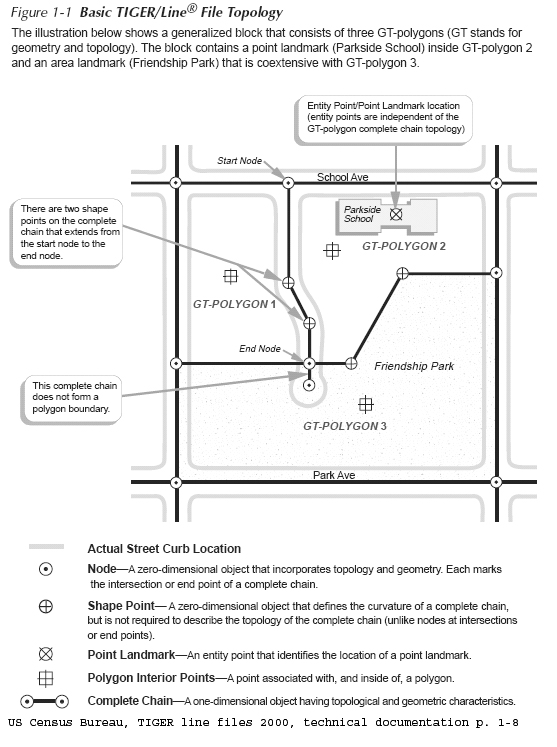
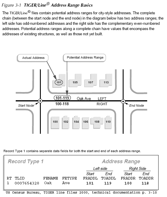
Example: using US Census Bureau, TIGER Line Files
- Geocoding Strategy using TIGER files (from earlier lecture
notes)
- Encode road network as street centerlines links connecting nodes (usually intersections)
- Attach address information to each street segment
- Use 'in reverse' to match street address to street segment to get approximate X,Y location
- TIGER: Topologically Integrated
Geographic Encoding and Referencing
system
- Examine attribute table and note columns for to/from information
- http://www.census.gov/geo/www/tiger/
- US Census Bureau TIGER line file 2000, technical
documentation
- in class locker: http://mit.edu/11.188/www/data/census2k/tiger_tgrrd2k.pdf
- Illustrative Example
|
Street
centerline road segments
|
Attaching address ranges to road
segments
|
 |
 |
How do GIS systems model Networks?
A shortest path is the shortest (or least 'cost' path) from a source node (origin) to a destination node. In practice, pathfinding seeks the shortest or most efficient way to visit a sequence of locations.
A tour is an enclosed path; that is, the first node and the final node on the path are the same node on the network.
A stop is a location visited along a path or a tour.
Events or locations may be viewed as collection points (e.g., 'origins' or 'destinations' ) where certain resources are supplied or consumed.
A turn on a network is the transition from one arc to another arc at a node (there are 16 ways in which two intersecting (one-lane) roads can allow vehicle flow among the 4 links that 'connect' to the one node).
'Location-allocation'
models often use network representation of connected places in
order to determine the optimal locations for a given number of
facilities (e.g., stores, restaurants, banks, factories,
warehouses, libraries, hospitals, post offices, and schools)
based on some criteria for assigning people to the the
'nearest' facility.
- For Lab #6, you use the GoogleWay API to run their shortest path algorithm to compute the walking distance from 'home' to each restaurant (obtained using Yelp points of interest).
- Another
common task is to create a 'service area' that comprises all
places that can be reached within X minutes from a specific
location. For example, how far from 77 Mass Ave can I
get on public transit within 30 minutes. Take a look
at the 'Make Service Area Layer' tool in the 'Analysis'
section of Network Analyst. Here are
links from earlier lectures to maps that display these types
of results:
- RedFin
(real estate marketing) site to find jobs with 30 minutes
without car: (launched in 2016 but no longer updated)
https://labs.redfin.com/opportunity-score?south=42.22947350329647&west=-71.20178445835722&north=42.48874784471439&east=-70.98449334164275&zoom=12 - Transit heat map (of one-hour access): http://www.transitheatmap.com/
Useful tools for
'publishing' project work
- Enable interactive manipulation of maps within browser, PDF document, etc. without 'running' GIS software
- Leaflet: javescript library to facilitate data exchange with backend web server (such as MassGIS server)
- See DUSPviz tutorial:
- Web Mapping workshop tutorials: http://duspviz.mit.edu/tutorials/
- Leaflet tutorial: http://duspviz.mit.edu/web-map-workshop/leaflet-js/
- Carto: additional libraries plus backend PostgreSQL (PostGIS) database access
- See DUSPviz Carto tutorial: http://duspviz.mit.edu/web-map-workshop/databases-leaflet-cartodb/