- Illustrate conversion of lat/lon values in table into shapefile of corresponding points
- Issues:
- Need to pull latitude and longitude out of 'location' field
- Use Excel functions (explained in exercise): =MID(G2, 5, 9) and =MID(G2, 21, 10)
- But, they get extracted as text. Convert to numeric (e.g., =1.0*b2...)
- Add adjusted worksheet from Excel into ArcMap
- Right-click: Display XY data to convert to points
- Remember to specify geographic coordinates (lat/lon, North America, NAD83)
- Results is an 'events' layer
- Still need to "Data / export data' into a shapefile before it is saved as a real shapefile
Network Analysis
Some additional information regarding Network Analysis from previous lectures that can be useful as further reference for Lab 8.
- Encoding proximity
using a network (or graph) model, facilitates
certain types of connectivity
analyses
- Find shortest path along streets from Point A to Point B
- Find shortest path through N cities (Traveling Salesman problem)
- How far can you get in 30 minutes
- Many transportation analyses use network data models
- Many hydrological analyses use network data models (runoff, flow, ...)
- Additional information on Network Analyst below
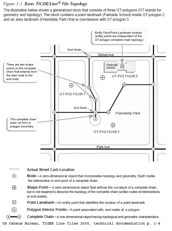
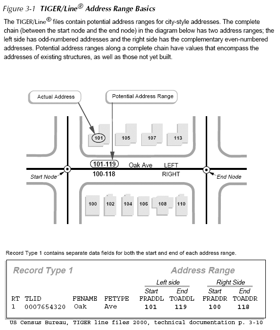
Network Example: using US Census Bureau, TIGER Line Files
- Geocoding Strategy using TIGER
- Encode road network as street centerlines links connecting nodes (usually intersections)
- Attach address information to each street segment
- Use 'in reverse' to match street address to street segment to get approximate X,Y location
- TIGER: Topologically Integrated
Geographic Encoding and Referencing
system
- Examine attribute table and note columns for to/from information
- http://www.census.gov/geo/www/tiger/
- US Census Bureau TIGER line file 2000, technical
documentation
- at Census: http://www.census.gov/geo/www/tiger/rd_2ktiger/tgrrd2k.pdf
- in class locker: http://mit.edu/www/data/census2k/tiger_tgrrd2k.pdf
- Illustrative Example
Street centerline road segmentsAttaching address ranges to road segments
What
is a Network?
Other basic elements of a
network:
A shortest
path is the shortest (or least 'cost' path) from
a source node (origin) to a destination node. In
practice, pathfinding seeks the
shortest or most efficient way to visit a sequence of
locations.
A tour
is an enclosed path, that is, the first node and the final
node on the path are the same node on the network.
A
stop is a location visited in
a path or a tour.
Events
or locations may be viewed as collection points (e.g.,
'origins' or 'destinations' ) where certain resources are
supplied or consumed.
A
turn on a network is the transition from one arc to another
arc at a node (there are 16 ways in which two intersecting
roads can allow vehicle flow among the 4 links that
'connect' to the one node).
'Location-allocation'
models often use network representation of connected places
in order to determine the optimal locations for a given
number of facilities (e.g., stores, restaurants, banks,
factories, warehouses, libraries, hospitals, post offices,
and schools) based on some criteria, assign people to the
the 'nearest' facility.
- For Lab #7, you need to run the shortest path algorithm to connect your observation points (in sequence) for each smartphone that was reporting to Mobile Forms.
- Another
common task is to create a 'service area' that comprises
all places that can be reached within X minutes from a
specific location. For example, how far from 77
Mass Ave can I get on public transit within 30
minutes. Take a look at the 'Make Service Area
Layer' tool in the 'Analysis' section of Network
Analyst.
Introduction to Web
Mapping with Leaflet
- Eric Huntley will illustrate web mapping of your field work data with Leaflet
- The dataset with HTML files and data are here:
- duspviz.mit.edu/resources/leaflet_tutorial.zip
- This (and many other) tutorials are available on
- Here
is today's tutorial (with coffee shops instead of your
field work points)