Massachusetts Institute of Technology - Department of Urban Studies and Planning

11.520: A Workshop on Geographic Information Systems
11.188: Urban Planning and Social Science Laboratory

Internet GIS and GeoSpatial Web Services


October 27, 2010, Joseph Ferreira


Administrative

  • Recitations this week: (review steps in site suitability analyses - such as in homework exercise; plus your questions)
    • Wed. 3:30 - 4:30 pm in Room 1-379 *TODAY* [different room, right after lecture]
    • Thurs. 2-3 pm in Room 9-450A
  • Lab #7 due Monday, Nov. 1, Lab #8 due Nov. 8 (last lab)
  • Homework #2: Part 2, due in one week (Wed., Nov. 3)
  • Homework #3: Raster Analysis and ModelBuilder, Part 1 due Wed., Nov. 10; Part 2 due Mon., Nov. 22
  • Project Proposals: Short (<1 page on topic, intention, and data sources) proposal due Wed., Nov. 17

Today

  • Introduction to Internet GIS and GeoSpatial Web Services
    • What do we mean by 'web mapping' or 'internet GIS'?
    • Distinguish between map publication, single purpose apps, and geoprocessing (interactive spatial analysis)
    • Decompose into server and client components
  • Demonstrate use of web services
    • MassGIS web mapping services (WMS) within ArcMap
    • ESRI web mapping services
    • Google mashups
  • Introduce Internet GIS concepts and strategies
    • Part of one-day URISA Workshop by Profs. Joe Ferreira and Zhong-Rhen Peng with additions by Prof. Mike Flaxman

Internet GIS and GeoSpatial Web Services

  • Introduction to Internet GIS and GeoSpatial Web Services
    • What do we mean by 'web mapping' or 'internet GIS'?
      • Yahoo Maps, Google Earth, Mapquest, etc. - are these GIS applications?
      • What about map 'mashups' on top of Google Maps and Google Earth?
      • What about iPhone maps and navigation tools?
    • Distinguish between map publication, single purpose apps, and geoprocessing (interactive spatial analysis)
  • Decompose into server and client components
    • Recognize pros and cons of client/server workload balancing
    • Recognize utility of open standards for interoperable geospatial web services
      • In this case, the web mapping service (WMS) protocol from the Open Geospatial Consortium
    • Enter these MassGIS URLs in a web browser
http://giswebservices.massgis.state.ma.us/geoserver/wms?dpi=120&request=GetMap&layers=GISDATA.EOTMAJROADS_ARC&srs=EPSG:4326&bbox=-71.1,42.35,-71.0,42.37&width=1000&height=300&format=image/png&service=wms&transparent=true
MassGIS-web-mapping-services-roads1
http://giswebservices.massgis.state.ma.us/geoserver/wms?dpi=120&request=GetMap&layers=GISDATA.NAVTEQRDS_ARC&srs=EPSG:4326&bbox=-71.1,42.35,-71.0,42.37&width=1000&height=300&format=image/png&service=wms&transparent=true
MassGIS-web-mapping-services-roads2
      • Do you recognize the meaning of the parameters? Play with the values...
        • http://giswebservices.massgis.state.ma.us/geoserver/wms?
        • dpi=120&
        • request=GetMap&
        • layers=GISDATA.EOTMAJROADS_ARC&
        • srs=EPSG:4326&
        • bbox=-71.1,42.35,-71.0,42.37&
        • width=1000&
        • height=300&
        • format=image/png&
        • service=wms&
        • transparent=true
      • Note that some services only produce maps at particular scales
        • Otherwise, get xml-tagged error message
      • MassGIS web services homepage: http://lyceum.massgis.state.ma.us/wiki/doku.php

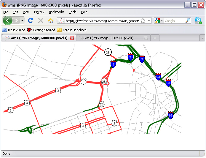
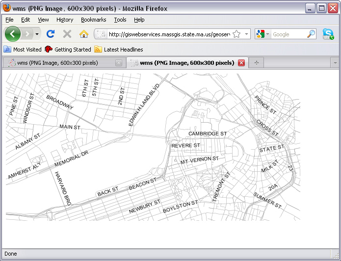
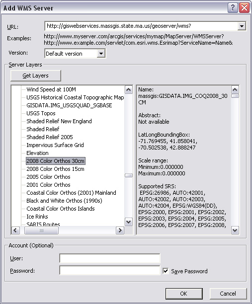
  • Demonstrate use of web services from within ArcMap

    • In ArcMap, add cambbgrp.shp to an empty Data Frame (to set the coordinate system and zoom to Cambridge)
    • Add MassGIS web mapping services (WMS)
      • Add 'GIS Servers' (instead of a shapefile, database connection, etc.)
      • Then choose 'Add WMS Server' (using GeoServer) at MassGIS
        • http://giswebservices.massgis.state.ma.us/geoserver/wms?
        • Click 'Get Layers' (and wait) to see the 100+ available layers
massgis-wms-server2
  • Click OK (then again) to add 'Massachusetts data from MassGIS...' to the ArcMap table of contents
    • It will be easier to select a few key layers after bringing the website into ArcMap
  • Right-click the layer to edit its properties; choose the following layers:
    massgis-web-services3
    • Note: the NavTeq layers are visible only if the scale is less than or equal to 1:50000
    • This next screen shot has the familiar Mass DOT major roads (symbolized) plus NavTeq local roads:

massgis-web-services-in-arcmap

    • ESRI web services
      • In ArcMap, add 'GIS Server' again
      • This time, 'Add ArcGIS Server' and choose:
        • user GIS Services
        • Set Internet Server URL = http://services.arcgisonline.com/arcgis/services
          • A new entry, 'arcgis on services.arcgisonline.com' will be added to the GIS Servers list
          • Choose this entry and click 'Add'
        • Select this service: ESRI_Imagery_World_2D and click 'Add' again
          • Ignore (but understand) the 'geographic coordinate system warning' window
          • This layer is similar to the MassGIS color orthos but is
            • worldwide not just massachusetts
            • uses proprietary protocols not just OGC web mapping service protocols
    • Map mashups

    • Google + Sketchup - Extra: we will explore this later (in lab )
      • Lab #1, we already used 'map to KML' to publish ArcMap maps within Google Earth
      • Explore "GeoModeling" with Google Earth and Sketchup (optional - not on exam or exercises)
        • In Google Earth, zoom in to the MIT campus
        • Overlay WMS services on top of Google Earth
          • Choose Add/.Image-Overly and use the following parameters:
            • Name: MassGIS-street-map
            • Link: use a version of the two MassGIS URLs illustrated above
              • First remove the EPSG and bounding box phrases since Google will fill those in
              • the width/height ratio must match your Google window or the map labels will be distorted
              • Try this URL for the major roads:
              • http://giswebservices.massgis.state.ma.us/geoserver/wms?dpi=120&request=GetMap&layers=GISDATA.EOTMAJROADS_ARC&EPSG:4326&width=600&height=480&format=image/png&service=wms&transparent=true
            • Refresh-tab: set "when" to be "after camera stops"
          • The MassGIS server will send an image overlay of local streets that Google Earth places in the appropriate place
          Place a to-scale model of Eiffel Tower on Briggs Field
          • Choose Add/Network-Link and select this file from the class data locker: M:\data\sketchup\eiffel_08nov06_v1.kmz
        • Keep Google Earth open and start Google Sketchup as well
          • Open the saved Eiffel Tower sketchup file in: M:\data\sketchup\eiffel_mit_08nov.skp
          • Click the "view your model in Google Earth" button (3rd from right side of tool bar)
            • The sketchup model will be placed into Google Earth in the same location as determined by SketchUp from the registered image that came from a Google Earth snapshot.
            • Some machines in the MIT labs will not allow this method of moving 3D models from SketchUp to Google Earth (do to file writing permission issuses). In that case, from Sketchup, choose File/Export/3D-Model and save your model to disk in KMZ format (zipped keyhole markup language, KML). Then open the file in Google Earth via Add/Network-Link.
        • Turn on 3D buildings in Google Earth and examine the scale of the Eiffel Tower compared with the playing fields and MIT buildings
        • Think about how Eiffel Tower model might be encoded for efficient and standard hand-off to Google Earth
          • Introduction to KML: http://code.google.com/apis/kml/documentation/
          • Homepage of Open Geospatial Consortium: http://www.opengeospatial.org
        • For more information about downloading and using Google Earth and Sketchup see:

  • Introduce Internet GIS concepts and strategies
    • Part of one-day URISA Workshop by Profs. Joe Ferreira and Zhong-Rhen Peng with additions by Prof. Mike Flaxman
    • Sample topics from PDF-formatted powerpoint slides
      • Slides 1-18 Intro
      • Skim Urban Planning applications of Internet GIS (slides 19-42, note MIT OrthoServer is now retired)
      • MassGIS web services example: slides 43-48
  • We will utilize various Internet GIS websites in Lab Exercise #8 on Monday


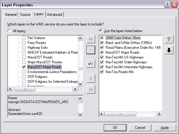
Created by Joseph Ferreira and Michael Flaxman, 2006-2007
Last modified 27 October 2010, Joe Ferreira
Back to the 11.520 Home Page.

Back to the CRON Home Page.