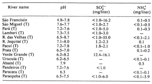
"Major rivers of the southeastern region [of Brazil] show pH values between 6.0 and 7.5. Thus, there is little or no evidence of acidification of either soils or surface waters." (pg. 293) 27.
-Acidification occurs naturally
-In tropical areas with high rainfall,
natural acidification of soils and surface waters is common
-Tropical areas also especially
sensitive to further acidification by increased atmospheric deposition of
sulfate and nitrate ions
-Three conditions for aquatic ecosystem
to be acidified by atmospheric deposition
-Atmospheric deposition of sulfate or nitrate or some other anion must increase
-Data on anion retention capacity?
-Adjacent soils to aquatic ecosystem must not retain the anion that is increased
in deposition
-Aquatic ecosystem must have low alkalinity for acidification to result
in biological damage. Aquatic ecosystems of this type are typically
associated with acid soils 26.
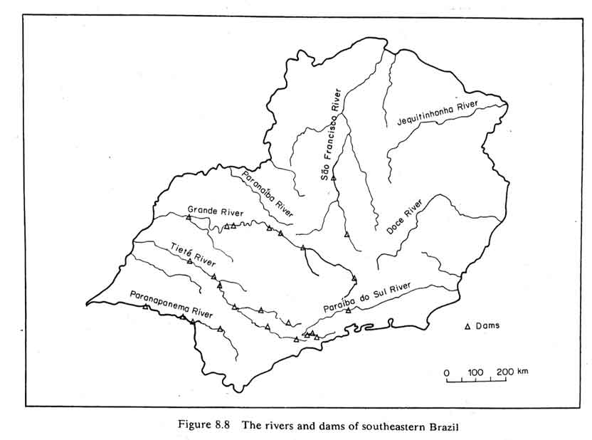
Rivers and Dams of Brazil (click to enlarge)
Characteristics of the major rivers and tributaries of the southeastern
region of Brazil 27
| -São Francisco
River -Runs 3.161 km -Drains 670,000 km2 -Well irrigated by rains in its higher part, semi humid and semiarid in its medium section, and humid again in coastal zone -Highest mean discharge in January -Max precipitation in December |
|
| -Paraíba do Sul
River -Results from confluence of Paraitinga and Paraibuna rivers, which have dams on their high reaches -Supplies water to 27 cities, also bears cities' wastes -Municipal pollution greater than industrial pollution -Draining area about 57,000 km^2 -Length 1,145 km |
|
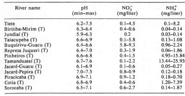
| -Tieté River
-Basin covers 84,170 km^2 draining area -30% is agricultural land, 30% reforested, 1.3% natural vegetation -Provides 28% of Sáo Paulo urban water supply -Receives about 300 tons organic matter daily -After crossing city, receives additional pollutants from agricultural chemicals and fertilizers |
|
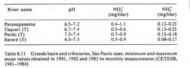
| -Paranapanema River
-Flows into River Paraná -About 900 km long -Basin draining area of 45690 km^2 -Excellent water quality, although some waste discharges from food industries, distilleries, paper mills, and cellulose plants -Mainly agricultural, with 14% reforested areas, 10% natural forests, in basin: 41% of the surface is pasture |
|
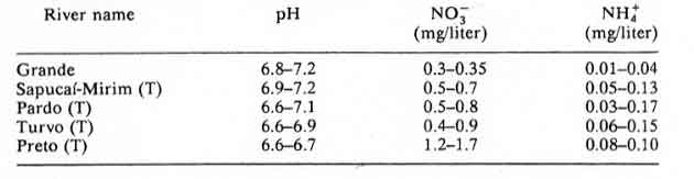
| -Grande River -Drainage area about 122,000 km^2 |
|
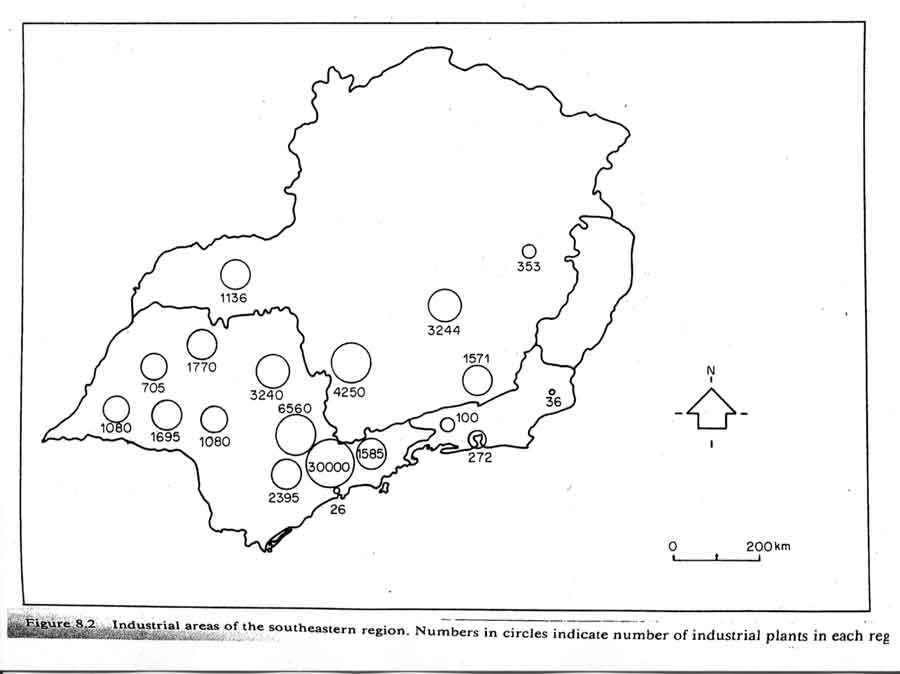
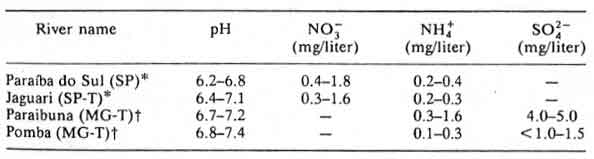
"Differences in nitrogen and sulfur concentrations observed in river waters of the southeastern region of Brazil cannot be explained by geological, pedological, or climatic factors. Higher N0-3, NH+4, and SO 2-4 contents were determined in rivers crossing urban and industrial areas, the same areas that also present a polluted atmosphere." (p.284)27.
City Characteristics:
-Cubatão:
-About
23 industrial sites, including chemical and fertilizer plants, metal works
and an oil refinery
-Natural
orographic barrier:
-Winds blowing from sea toward continent meet the Sierra do Mar
-Prevents pollutants from dispersing
-Rainy
season December 1982 show rainwater pH in downtown Cubatão varied
from 3.7 to 4.7 while values in nearby Vila Parisi ranged from 5.8 to 6.8
-São Paulo City
-pH values
of rainwater from 6.33 to 2.67, with mean value 5.0
-in precipitation,
high Ca 2+ and high K + concentrations
-Likely due to large quantity of cement dust in the air27.
Pollution creation:
3 major metropolitan areas:
Rio de Janeiro, Belo Horizonte, and Sao Paulo
-Cover only 2% of southeastern
region, but emit about 450,000 tons/year of SO2 into atmosphere
-Low wind speeds of southeastern
region allow deposition of pollutants near emission sites
-Principal emission sources:
metal smelting and metal working industries, electric power plants, fertilizer
and heavy chemical industries
-Principal air pollution sources
outside urban areas: Biomass burning and animal waste disposal
27.
Recommendations for Research
Environmental monitoring activities
by states and municipalities of southeastern region
-Facilitate
regional comparisons of results and environmental conditions
-Permanent monitoring networks
in selected rural and urban areas
-Determine spatial and temporal gradients in precipitation chemistry and
concentrations of airborne gases, fine aerosol particles, and coarse particulate
matter
-Main chemical constituents to study: pH, conductivity, amounts of
major cations and anions, amounts of organic acids, sulfur dioxides, nitrogen
dioxide, ozone, ammonia and nitric acid vapors, heavy metals in air and precipitation
-Permanent monitoring networks
to measure seasonal and multiannual trends in flow rates and chemistry of
both headwater streams and major rivers
-Chemical constituents: pH, conductivity, alkalinity, amounts of major
nutrient cations and anions, selected heavy metals
-Permanent monitoring networks
to determine long-term changes in chemistry of soils and groundwater aquifers
27.
![]() The Massachusetts Institute of Technology
Contact: lacooney@mit.edu
The Massachusetts Institute of Technology
Contact: lacooney@mit.edu
_______________________________________________________________________________________________________________________________________________________________
Research Bibliography
***Note: I will update these web-sites as correct bibliographical
entries soon.
1. Palaeoceanography Environmental Change Research Centre
2. Land Surface Hydrology and Water Chemistry The Large Scale Biosphere-Atmosphere Experiment in Amazonia (LBA)
3. The source of the Amazon River was just recently discovered. Why did it take so long? National Geographic Society
4. Tropical Deforestation Fact Sheet NASA Earth Observatory
6. Amazonia - Resiliency and Dynamism of the Land and its People Nigel J.H. Smith, Emanuel Adilson S. Serrão, Paulo T. Alvim, and Italo C. Falesi, United Nations University
7. Solving the Amazon?s climate riddle By Ginger Pinholster, SCIENCE
8. Fish in the Trees by Rachel Hauser, NASA Earth Observatory
9. River Seasons by Laura Cheshire, NASA Earth Observatory
10. http://www.gsfc.nasa.gov/gsfc/educ/science/2001/01-04-01.htm
11. Amazon Deconstruction: Cause and Effect camille, charlie, hsing hsing, maya, pete, University of Washington
12. "Applications of Hillslope Process Hydrology in Forest Land Management Issues: The Tropical North-East Australian Experience", Mike Bonell
13. Dictionary of Geography, Oxford University Press
14. "WATER RESOURCES MANAGEMENT
FOR ENERGY GENERATION PURPOSES IN STREAMS PRESENTING STRONG SEASONAL FLOW
VARIATIONS - PLANNING ASPECTS",
Bela Petry & Doron Grull
15. "Analysis of the
Streamflow Record Extension for the Xingu River at Babaquara Maria
Elvira Pineiro Maceira and Jorge Machado Damazio
16. Seasonal Variations in the evapotranspiration of a transitional tropical forest of Mato Grosso, Brazil George Vourlitis, Nicolau Priante Filho, Mauro Hayashi, Jose de S. Nogueira, Fernando Caseiro, Jose Holanda Campelo
17. Towards improving natural resources use in Eastern Amazonia through a modified sequential agroforestry system Sa, T.D. de A.; Vielhauer, K.; Kanashiro, M.; Denich, M. and Vlek, P.L.G.
18. Cloud condensation nuclei in the Amazon Basin: "Marine" conditions over a continent? Gregory C. Roberts and Meinrat O. Andreae; Jingchuan Zhou; Paulo Artaxo
19.
Rates and Processes
of Amazon Deforestation Michael Glantz, Tandy Brook, Patricia Parisi