| Home
Mission 2007 Team Research Sources Progress Journal |
|
Research Geography
The Arctic National Wildlife Refuge spans 9.6 million acres and lies on the
edge of the Artic Ocean and, bordered by Prudhoe Bay to the West and the
Canada to the East (A_text.htm). The 1002 area, 1.5 million acres
of northeastern ANWR, lies on the Coastal Plain of ANWR and is situated
in the 100 miles (Land Forms) between the Aichilik River to the east
at 142?10' W and the Canning River to the west at 146?15' W. It
is trapped between the Brooks Range Mountains located at 69?35' N and
the Beaufort Sea at 0?10' N, and its close proximity to the two
ecoregions produces a variety of ecological conditions and habitats which
support a wide spectrum of vegetation (Arctic Refuge).
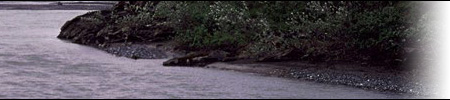
The entirety of ANWR spans many regions, including the Arctic coast, the tundra plain, the
Brooks Range Mountains, and the Yukon basin forests. It contains over 20
rivers, including National Wild Rivers the Sheenjek, Ivishak, and Wind; North
America's largest and most northerly alpine lakes Peters and Schrader; warm
springs; lagoons; and glaciers. In the 1002 area, specifically, there are
also many rivers that run northward and a few large lakes which freeze all
the way to their bottoms by winter. Polygonal patterns on the ground across
the region are formed by the seasonal thawing of the surface which will be
explained in greater detail in the hydrology section. The disturbance of the
surface tundra results in permanent alteration of the terrain, including the
creation of ponds, ice wedges, vegetative cover and erosion (Arctic
Refuge).
|

| Last updated: Nov 19, 2003 | Team 5 - m2007-5@mit.edu |