Anna Jaffe, member Team 2 of Las Tortugas
Abiotic Systems
The information found below has been more difficult to find, and as a result will be updated as regularly as possible. Beyond the many awesome interconnections between the biotic and abiotic components of this world, my interest here is peaked by the tendency of matter to appear more complex, and yet in balance in its complex physical form, than one would guess if all you had to go on was atomic, or electronic structure. The Galàpagos are particularly fascinating in that you have a chance to see the dynamics of many components of our world often considered to be rather static. (Along these lines, the Gaia Hypothesis is a pretty neat piece to look at while trying to understand natural processes on both micro and macroscopic scales).
Art, Henry W. The Dictionary of Ecology and Environmental Science. Henry Holt and Co, NY, NY 1993.
Ecosystem: A functioning unit of nature that combines biotic communities and the abiotic environments with which they interact. (biogeocoenosis)
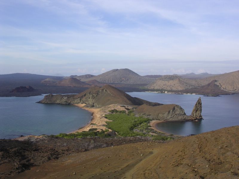
Ecotone: A transition area between two or more distinct habitats or ecosystems, which may have characteristics of both of its own distinct characteristics. (See edge effects)McBirney, A. R. and H. Williams, Geology and Petrology of the Galapagos Islands. The Geological Society of America, Boulder, CO, 1969.
- Albemarle (Isabela Island), page 54
- 70 miles long by 40 miles at its widest point
- composed of 6 coalescing volcanoes, 5 active shield with caldera
- 14 eruptions since 1911 Cerro Azul (5), Sierra Negra (3), Alcedo (1), Wolf (5)
- Cerro Azul, 5540 ft
- lower slopes covered in lava, high slopes pyroclastic ejecta
- solfataric activity within caldera
- Sierra Negra Volcano, 4890 ft
- calder 6 by 4 miles, 350 ft deep
- “large solfatara with conspicuous deposits of sulfur”
- recent lava flows on outer slopes
- Alcedo Volcano (3700 ft)
- fresh lava flows on flanks and saddle w/Darwin
- caldera contains boiling pools releasing hydrogen sulfide
- prolific pumice along base of trachytic composition
- Darwin Volcano (Mt. Williams, 4350 ft)
- radial fissures active
- Tagus and Beagle Cones
- composition rich in sideromelane => palagonite
- none expel lava
- initially, independent islands
- Salt lake in Beagle cone
- contains four nested craters, three with peripheral vents
- North slope of scoria and agglutinate
- Wolf Volcano (Mt. Whiton, 5600)
- caldera measures 3 by 4 miles by 2000 ft
- recorded eruptions 1797, 1800, 1925, 1933, 1935, 1938, 1948, 1963
- Cape Berkeley Volcano (2600 ft)
- Only 1/3 remains above sea level
- composed of basaltic lava
- steepest slopes of any archipelago volcano
- two parallel fault lines along cliffs-2500 parasitic cones (not more than 500 feet) running parallel to the primary chain
- //of all this material, which would make the most advantageous building material? What could easily be harvested without disrupting the ecosystem? Where does the balance between imported goods and using local resources lie, and how does this balance limit the total number of residents?//
- Petrography
- lava samples collected from cape Berkeley
- primary composition: olivine basalts, sodic labradorite, augite
- plagioclase phenocrysts, labradorite laths, clinopyroxene, magnetite, glass
- Fernandina (Narborough) Island
- Measures 18 by 15 miles
- below 1000 ft, slopes mild, 1000-4000 ft 15-34??q
- caldera 2500 and 2750 feet deep
- present state comparable to Mauna Loa and Kilauea => tholeiitic basalt flows
- circumferential fissures around caldera
- 10 eruptions since 1813
- In 1946-1957, caldera contained large lake, disappeared in 1958-neat thought with respect to eruption of 1968, “Inrasonic long-wave shocks resulting from these explosions were recorded throughout the western hemisphere. Their amplitude measured at Boulder, CO, was comparable to that of the largest nuclear explosions.” (80)
- during eruptions, movement within cladera tends to occur along elliptical fault line
- primary composition: phenocrysts and glomerocrysts of sodic bytownite, olivine
- “groundmass has intergranular texture consisting of … calcic laboradite, augite, glass rich in magnetite”
(World Heritage Sites report on the Galapagos)
"There are two seasons due to the shifting of the currents. The dry season, caused by the Humboldt current, is characterised by cool temperatures (17°C-22°C), a fairly persistent fog or 'garua' that envelopes the highlands of the larger islands in mist and drizzle, and south-easterly winds. The variable short, hot season, caused by the warm current, is characterised by warmer temperatures (23°C-27°C), light easterly winds and seasonal rains. Approximately every four years, heavy rainfall occurs during this season. Temperatures generally decline by some 0.9°C for every 100m altitude. At the wettest place at sea level, the mean annual precipitation is 356mm, whilst at 200m above sea level the equivalent figure is 1092mm (UNDP/UNESCO, 1974)."