Corals and Coral
Reefs Galapagos
Islands Glynn, Wellington, Wells Santa Cruz -
coral formations: Academy Bay (southern coast)
Supports 8 hermatypic, 3 ahermatypic
coral species in habitats of rock walls and ceilings of overhangs
The bay is marginal for reef-building
corals (low water visibility, frequent exposure to southern swells from
June-December
Conway Bay (western coast) Santiago - Southeast
of Boquerizo point, offshore 2-10 meters - abundant branching coral
pufferfish and parrot fish are abundant here Bartolome Island -
reef-building corals along South, Southwest shores
upper
reef flattened because of low water levels. back to top www.darwinfoundation.org
Management Plan of the Galapagos Marine Reserve - Approved March 1999
Zoning - used to regulate/manage use of each resource in defined
sub-zones
3 Zones: Multiple use, limited use, and docking use Limited Use - extends
out from coast
considered fragile habitat
where majority of marine diversity and
fishing resources are concentrated
Sub-Zones: fishing (extractive)
tourism (non-extractive)
science (non-extractive)
education (non-extractive)
8% of coastline protected
10% non-extractive
77% "zone of conservation, extractive/non-extractive use"
5% zone for recuperation
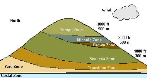
back to top www.galapagos.com Vegetation Zones: Coastal Zone -
evergreen zone
mangrove forests; vines,
grasses, shrubs on beach
few endemic plant species (most
are "immigrants" from the sea) Arid Zone - Most
extensive zone
semi-desert forest dominated by deciduous
trees/shrubs
lichens abundant, sa well as plants adapted to
survive drought
many endemic species Transition Zone -
Deciduous forest
more dense and
diverse than arid zone Scalesia Zone - Lush
cloud forest, predominantly scalesia pedunculata trees
richest in terms of soil
fertility and productivity
extensively cut down for
cattle grazing and agriculture Brown Zone - open
forest with mainly cat's claw and other trees
trees covered in mosses, liverworts,
and ferns (brown in dry season)
zone has virtually disappeared
because of colonizatino by man Miconia Zone - found
on southern slopes of Santa Cruz
dense shrubbery belt
no native trees, but ferns
and liverworts present Pampa Zone - virtually
no trees or shrubs
mainly grasses and sedges
wettest zone (averaging 2500 mm
rain per year) back to top www.library.thinkquest.org Life Zones:
1. Desert Tropical Thicket
(Littoral Zone) -
elevation = 0ft - 35 ft
occupied by ocean at high tide
dominant species = mangrove
Average temperature = 70 degrees F
2. Thorny Tropical Thicket
(Miconia and Arid Zones) -
elevation = 35 ft - 400 ft
vegetation is mostly cacti (like prickly pears), which dominate rocky
areas
Average temperature = 70 degrees F
3. Thorny Pre-Montane
Thicket (Transition Zone) -
elevation = 400 ft - 600ft
trees
are taller and air is more humid
epiphytes, grasses, and ferns are abundant
temperature = 60 - 70 degrees
4. Dry Tropical Forest
(Humid, Pampa, and Brown Zones) -
elevation > 600ft
Mostly
humid, dense forest of epiphytes, vines, ferns, fungi, mosses, and
lichens
temperature = 60 - 70 degrees back to top Galapagos John Krichner Santa Cruz
-
coastal: palo santo trees, matazarno
bushes, tall cacti (barren appearance)
higher elevations: agriculture, fields
of imported elephant grass
plantations of bananas, coffee, papaya, and avocado
reddish soil yieds agriculture similar to Central and
South America
wetter highlands (scalesia zone): 8
taxa of scalesia tree
gray-jbarked
guayabillo, reddish-barked guayabo trees
higher
up - cacaotillo replaces scalesia
guara
mist - supports orchids, bromeliads, ferns, mosses
Twins Craters (10 miles from Puerto
Ayora):
surrounded by we4t habitat similar to high-elevation humid zone
many of Darwin's Finches live here (ground finch, tree finch, warbler
finch, and woodpecker finch)
woodpecker finch - usually uses cactus spines to probe for food, but
here must behave differently
Tortoise Reserve(SE of Santa Rosa)
Wild
populations of Santa Cruz domed shell tortoises (>1000)
overnight camping permits available for visitors
Black Turtle Cove Lagoon (N side of
island)
Animals include Brown pelican, noddies,
blue-footed boobies
Red mangrove trees: roots in water provide
habitat for pufferfish, oysters
golden rays, round stingrays live in water
best place on island for viewing green sea
turtles Santiago -
Sullivan Bay: area completely covered
in cooled lava (pahoehoe and aa)
animals
include doves, Galapagos Hawks
vegetation limited to a few cacti and hardy shrubs
James Bay: abundance of salt sage
(which goats and donkeys strongly avoid)
Pan de Azucan (a volcanic
cone) located here
slopes have palo
santo treess and muyuyo , summit has scalesia
Espumilla Bay: Black volcanic sand
sea turtles lay eggs here
Buccaneer Cove: saltwter lagoons
frequente3d by flamingos, Galapagos hawks, doves, and mockingbirds
7 Vegetation Zones:
1. Coastal - plants:
salt bush (salt-tolerant, near ocean)
salt sage - grows in dense mats
Mangroves - highly tolerant of salt, prop roots dangle
from branches
2. Arid - plants:
indicator species = candelbara cactus
palo santo deciduous tree (dominant), grows widely
spaced, covers hillsides at low elevations
cacti - prickly pear - grows as large as a tree, many animals depend on
them (keystone species)
lava cactus (on Santiago) matlike, grows on lava flows
Manzanillo (poison apple tree)
Galapagos tomato
3. Transition -
indicator species = pega pega (small tree with brown hair-like wool
under leaves) and guayabill (small shrub, leathery leaves)
zone between hot/dry, warm/cool
climates
trees laden with epiphytes
4. Scalesia -
defining plant = scalesia pedunculta (known on island as lechoso)
zone enshrouded in garua mist most of year
characterized by abundance of epiphytes
(non-parasitic, only occupying surface on branches)
best region for agriculture (on Santa Cruz
natural vegetation has been replaced by agroecosystems)
5. Brown - indicator
species = cats claw (shrubby tree with sharp spines)
name derives from accumulation of fallen epiphytes on
ground, which make it look like a brown carpet
6.Miconia -
identifying species = cacaotillo (miconia robinsoniana)
zone is essentially above tree-line
open shrub land with dense carpet of ferns
interspersed with miconia plants
Santa Cruz and San Cristobal are only islands with Miconia
7.Pampas - zone with
greatest exposure to elements and most precipitation
peat bogs common
tallest vegetation = 12-foot tree ferns back to top