LAYOUT/TERRAIN

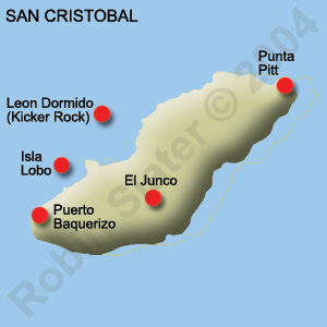
A map of San Cristobal and major cities.
The Islands' Capital, Puerto Baquerizo, is
shown as the southern most city on the map.
- 97% of the islands are preserved national parks.
- 3% is reserved for Ecuadorians to live on the island.
- Only a small part of the Scalesia Zone is left on San Cristobal because much of it has been destroyed for agricultural and cattle ranching purposes.
- The southern slope of San Cristobal is one of the only places where Miconia robinsoniana still exists.
- There is a paved road on this island that runs from the capital, Puerto Baquerizo Moreno to El Progreso and it continues along the eastern slope of the volcano, Cerro San Joaquin and ends at El Junco, the freshwater lake. The paved road offers a scenic drive and takes travelers through coffee plantations and Scalesia and Miconia Zones.
A map of the Galapagos Islands.
A map of San Cristobal and major cities.
The Islands' Capital, Puerto Baquerizo, is
shown as the southern most city on the map.