
| 1. Better production based in
ecologically sustainable agricultural technologies. Activities: • Water issues: Galapagos farmers use water high in salinity, which causes major damages to the soil and the produce cultivated. The CDRS is experimenting with specific chemicals to add to the brackish water currently used by the farmers as a test project. Treated water is provided to farmers, which hopefully will improve the quality of cultivation • Implement model farms in Santa Cruz, San Cristóbal, and Isabela: these three farms have been implemented; growing supplies have been purchased; and demonstrative nurseries have been developed. Farmers can visit these farms to learn more sustainable growing techniques and some have the opportunity to work on the farms. • Complete a campaign and monitoring program for plagues: working with the education department and SICGAL (System of Quarantine), an awareness program has been created. Farmers are motivated to provide samples of invasive insects in their crops to the Station for monitoring and research to find eradication or control methods. Station staff members continuously provide samples to the entomology department for study. Most farmers do not use chemicals in their crops. In certain cases, where plagues are devastating, farmers are encouraged to use chemicals for short periods of time to combat the plagues, and then work to maintain biological control through organic farming. • Providing ongoing technical assistance and training: Monthly courses are held for farmers to learn techniques for better quality crops, rehabilitation of poorly treated land, education in farm and plague management. Themes of courses follow along with the seasons. For example, during watermelon season, the focus is on sustainable cultivation of watermelon, how to use the water and soil efficiently, etc. The Station provides materials, including seeds, to farmers in order to show possible differences and improvements. 2. Functioning systems and channels of collective commercialization. Activities: • Design and implement a market system: staff has monitored the local markets to develop strategies for better marketing by the local farmers. One issue is that the farmers all grow the same crops, often growing too much of one crop and not enough of another. The result is crops that cannot be sold, as the market has already been filled. The Station works to teach marketing strategies to the farmers, and provide suggestions for types of produce that will likely be successful in the market. • Create partnerships between the agricultural sector and tourism sector: if the agricultural sector is able to provide for the needs of the tourism sector (mainly boats that carry passengers), there will be less need for produce to be brought from the continent (lessening the number of possible introductions of species) and it will offer better economic opportunities to the agricultural sector by removing outside competition. Cooperations are currently being developed, and so far a number of the smaller tourist operators are purchasing their produce needs from Galapagos farmers. |
||
| Expected
Results: This project combines agricultural and conservationist sectors that historically have had tensions in Galapagos. It attempts to change the intensity and negativity of human impact upon the ecosystems in order to protect this world heritage site. The expected results during the life of the project are: • Improved production based in ecologically sustainable agricultural technologies • Functioning systems and channels of collective commercialization • Strengthened and efficient farmers’ organizations. The long-term result is to have created sufficient conditions for the farmers of Galapagos to satisfy the local and tourism demand for fresh products (self sufficiency of the islands and decrease in imported produce, plagues, and invasive species). |

Ownership arrangements may
vary too. The core areas of biosphere reserves are mostly public lands,
but may also be privately owned or belong to non-governmental
organizations. In many cases, the buffer zone is in community or
private ownership, and this is generally the case for the transition
area.
| General Description | The Archipiélago de Colón –(Galápagos) Biosphere Reserve (also a National Park and a World Heritage site), is situated in the east Pacific Ocean, 1,000 km from the mainland of Ecuador, with the equator running through the Wolf and Ecuador volcanoes on Isabella Island. Situated on the Galapagos Submarine Platform, the Galapagos Islands consist of 13 islands. These islands were formed 4 million years ago by volcanic processes and most represent the summit of a volcano, some of which rise over 3,000 meters from the Pacific Ocean floor. The larger islands typically comprise one or more gently sloping shield volcanoes, culminating in craters or calderas and the terrain are generally composed of uplifted marine lava flows. More than 250 species are non-native introductions occurring predominantly around human settlements. Coastal vegetation, influenced by the presence of salt, occurs along beaches, salt-water lagoons and low, broken, boulder-strewn shores. The endemic fauna includes invertebrate, reptile and bird species. There are a few indigenous mammals. All the reptiles are endemic, except two marine tortoises, and include giant tortoise (Geochelone elephantopus) , terrestrial iguanas (Conolophus subcristatus and C. pallidus), and marine iguana (Amblyrhynchus cristatus). The 1999 resident population numbered some 15,600 persons. Freshwater is a critically limiting factor, and only San Cristobal has adequate perennial supplies for the local human population. Tourism, cattle grazing and fishing are key components of the islands' economy. Immigration from the mainland is uncontrolled and increasing. Approximately 49,000 foreign and 14,000 national tourists visited the islands in 1997. The Government of Ecuador, IUCN and UNESCO - WCH, support the Charles Darwin Research Station jointly and work in programmes, which assist in the management of the reserve. | ||
| Major ecosystem type | Tropical humid forests / Marine archipelago | ||
| Major habitats & land cover types | Littoral zone; arid habitats; Scalesia forest composed of S. pedunculata, S. microcephala and S. cordata; Miconia communities with M. robinsoniana; Matazarno forest with Piscidia carthagenensis; fern- and sedge communities; marine habitats; agroecosystems with coffee, tomato, pepper, fruit etc.; pasture land. | ||
| Location | North:
Darwin Island: 01°39'N; 92°00'W South: Floreana Island: 01°17'S; 90°26'W East: San Cristóbal Island: 00°48'S; 89°25'W West: Fernandina Island: 00°22'S; 91°31'W |
||
| Area (hectares) | |||
| Total | 14,761,844 | ||
| Core area(s) | 65,040 | ||
| Buffer zone(s) | 696,804 (defined as primitive-, special use- and visitor use zone) | ||
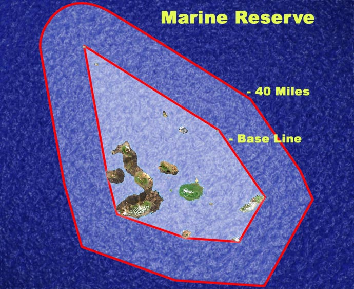
| Transition area(s) when given | 14,000,000 (marine reserve zone) | ||
| Altitude (metres above sea level) | 0 to +1,707 | ||
| Year designated | 1984 | ||
| Administrative authorities | Parque Nacional Galápagos | ||
| Research and
Monitoring |
|||
| Brief description | Geology
and meteorology Galapagos giant tortoise (Geochelone elephantopus) breeding and raising in captivity Galapagos land iguana (Conolophus subcristatus) breeding in captivity Dark-rumped petrel (Pterodroma phaeopygia) conservation Eradication and control of introduced organisms Restoration of plant communities |
||
| Specific variables... | |||
| Abiotic | Geology, meteorology. | ||
| Biodiversity | Birds, breeding/reproduction, community studies/communities, conservation, plants, reintroduction, reptiles, restoration/rehabilitation/redevelopment. | ||
| Related links |
|||
| World Heritage Site: |
Galapagos
Islands Check
this out!! Gives a good summary... Biosphere Reserve in focus (February 2001) |
||
Zoning of the national park and
visitor sites
Zoning of the marine reserve for tourism and visitor sites
Summary of main aspects of management plan:
Main stakeholders involved: