Climate
"Considering that
these islands are placed directly under the equator, the climate is far from
being excessively hot."
"Excepting during that one short season, very little
rain falls, and even then it is irregular, but the clouds general hang low."
--Charles Darwin, The Voyage
of the Beagle
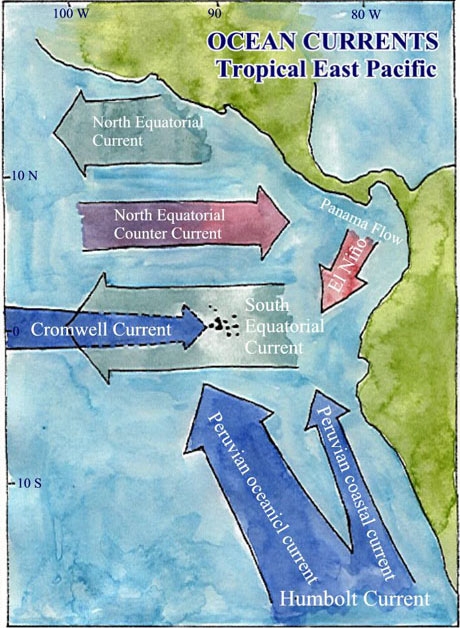
The reason why the Galapagos Islands were not as hot as
Darwin expected is because of the ocean current known as the Humbolt (Peru)
Current. As it passes Peru, the Humbolt current bends to join the Equatorial
Current flowing westward across the Pacific Ocean, hitting the Galapagos
with cool water. The Humbolt itself maintains a mean temperature of
15°C. It is this cool water that keeps the Galapagos climate from
being as warm as other tropical islands. Upwelling also brings cool
water along with nutrients from the ocean depths. The Cromwell Current
(Subequatorial Countercurrent) is the principle reason why the marine environment
surrounding the Galapagos is so interesting. The Cromwell Current is
a deep flow of ocean waters originating in the Western Pacific. It
runs beneath the equator in the opposite direction to the bulk westward movement
of surface waters (Southern Equatorial Current). At its core, the Cromwell
has a temperature of 13°C. When the current encounters the submarine
Galapagos platform, it upwells to the west of Fernandina and Isabela and
dissipates toward the center of the Galapagos. It is the resultant
nutrient-rich water that promotes bioproductivity around the Galapagos.
The windward sides of the islands (toward the southeast) generally receive
more moisture than other sides. An increase in precipitation creates
climatic zones that occur as moist ocean air is forced up over the islands.
Ocean cools the lower part of the atmosphere, creating a temperature
inversion at around 200-300 m.
The Galapagos Islands see only two major seasons a year. The dry, or
garua, season lasts from July to December. The hot, wet season occurs
between January and June with March and April being the wettest months of
the season. Around December, several changes occur in the atmospheric
and oceanic currents. The trade winds slacken and the "International
Convergence Zone" (the climatic equator located just north of the geographic
equator) shifts southward toward the Galapagos. The slacking trade
winds cause the Southern Equatorial Current, a westward current, to slow.
This reduces upwelling, and warm water invades the islands. Ambient
air, in turn, warms, and the inversion layer breaks down. Warm air
then rises to the point where rain clouds form and daily afternoon showers
occur. Even with this added precipitation, however, low elevations
on the islands still receive only limited rain. Interestingly enough,
the highland areas of the islands receive more moisture from the garua (the
mist that develops at upper elevations) than from rain.
Research
Geography
and Geology
Geoindicators
Home