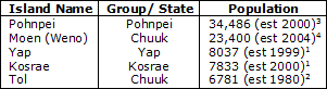
Evacuating the Islands
Because Micronesia is made up of 607 islands, we deemed it unfeasible to focus on a
specific evacuation plan for each and every one of the populated islands. Therefore, our
evacuation plan is specific for the six most populated islands, and we have made general
recommendations for the smaller/less populated islands. We based initial population estimates
off of information from the UN System - Wide EarthWatch Website
(http://islands.unep.ch/ILV.htm) to get a list of the most
populated islands and then updated population estimates from there. Here are the islands we
are evacuating:
1http://www.prel.org/
2http://islands.unep.ch/ILV.htm
3http://lumahai.soest.hawaii.edu/Enso/map/usapi/pohnpei.html
4http://www.tageo.com/index-e-fm-cities-FM.htm
Small Islands
The reason why we aren't concentrating on every populated island is because there are 607 islands, and most of these have people living on them, at least 100 people (source). Therefore, it is not practical to focus on every island. Also, the total population of Micronesia is 107,008, estimated 2000 (source), and the islands we are covering total 80,537, or 75.3% of the population. Tsunami warning will still be provided for these small islands, and at the sound of the siren, it is recommended that everyone evacuate inland at least 2 miles (3.22 kilometers). The tsunami signs will still be placed on these small islands, with the same sign: population ratio as on the larger islands.
Pohnpei (also Ponape)
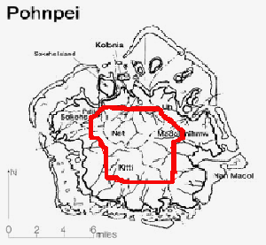
Basic Safety Evaluation
Pohnpei Island was formed, similar to many other islands in the FSM, from a volcano. Therefore, its land is relatively high in elevation, with its highest altitude at 791 meters. There are large barrier reefs around the island and extensive mangrove forest development along the shoreline (source). Because of these characteristics, first of all, people are probably already located at high elevations where the tsunami will not reach, and second of all, there will be a lot of warning time because the barrier reefs and mangrove forest will act as buffers for the island, delaying the waves and dissipating some of the energy in the tsunami (source).
Evacuee Estimate
The major cities on this island are Palikir, with a population of 10,100 (source) and Kolonia, with a population of 4,540 (source). Palikir is at an elevation of 682 feet and Kolonia is at an elevation of 9 feet (source), so excluding the population of Palikir, we estimated that there were 25,000 people living in danger areas along the coast. We cannot assume that anyone else besides the population of Palikir lives far enough away from the coast because the only accurate data available for specific populations on Pohnpei is for large cities. Kolonia's elevation proves that there is a significant number of people living on the coastline where a potential tsunami might wreak havoc. We are taking the maximum run-up of the tsunami to be about 15 meters, or around 45 feet, which will significantly impact most people living on the island. Therefore, the upper evacuation estimate for Pohnpei is 25,000 people.
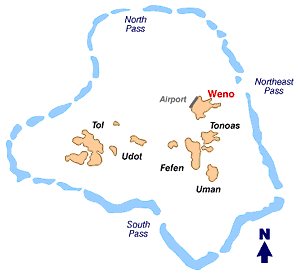
Weno (also Moen)
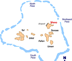
Basic Safety Evaluation
Weno, 18.8 square kilometers in area, has a maximum altitude of 370 meters. There are many mangrove forests along the coastline and extensive barrier reef systems, around both Weno and the state of Chuuk (see diagram) (source). The smaller islands present in the Chuuk island group will also act as buffers between the force of the tsunami and the main island. Again, because of these factors, we are likely to have at least an hour from the warning system.
Evacuee Estimate
Weno is such a small island that it is difficult to find information for locations of population centers. Therefore, we decided to estimate that the entire population of Weno will need to be evacuated. This is probably not an unreasonable estimate because Weno's population increased drastically after its airport was built, and the airport is located on a filled-in reef, which is probably not much higher than sea level. In that case, the number of people needing to be evacuated inland 2 miles is 23,400, the total population of the island.
Yap

Basic Safety Evaluation
Yap the island is actually nearly inseparable from the other islands Gagil Tamil, Map (also Maap), and Rumung, as apparent from the map. This evacuation estimate will cover all four islands, which will collectively be referred to as Yap. Yap has many barrier reefs surrounding the island but the island itself is located on the farthest edge of the FSM island group, so there are few small islands to buffer and dissipate the tsunami force. Yap is likely to be hit the hardest in the event of a tsunami. In fact, a 6.6 magnitude earthquake occurred near Ulithi, another island in the Yap island group, on January 16, 2005 (source). Also, a 1999 earthquake near Taiwan of magnitude 7.6 generated tsunami warnings for Yap specifically, among other countries (source). Therefore, not only the likelihood of a tsunami higher in Yap than any other state in the FSM, warning time may be low because of a lack of a smaller island buffer.
Evacuee Estimate
The main city in Yap is Colonia (different from Kolonia in Pohnpei), which is a port city. While its average elevation is 56 feet (source) and thus above the run-up estimate of 45 feet, most people are likely to live closer to the coast than the average elevation suggests. Also, large tsunamis do have run-ups greater than 45 feet, so Colonia is likely not safe from tsunami damage. Colonia is estimated to have a population of 4500 (source), so considering the overall population of 8037, we can consider the entire population of the island to be in danger of a tsunami and therefore the total population of 8037 must be evacuated at least 2 miles inland to reach a proper elevation and the safety zone of the island.
Kosrae
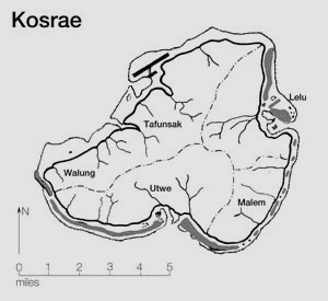
Basic Safety Evaluation
Kosrae, the island group, is unique among the four island groups of FSM in that it consists of one large island with no small islands at all. While it does have barrier reefs and mangrove forests, the lack of island buffers will probably cause Kosrae a great deal of harm during a tsunami. It is also the rightmost island of FSM, and a tsunami could gather a lot of speed crossing the ocean and then hit Kosrae with a lot of force.
Evacuee Estimate
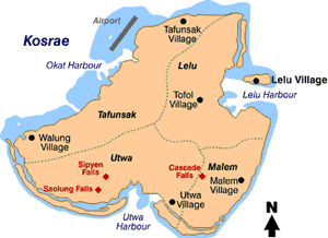
Apparent from the map above, the centers of population are close to the edge on an island that is 110 square kilometers. Lelu Village, which has an elevation very close to sea level (source), has an estimated population of 3100 (source), although this estimate is a little questionable because the village is located on a sub-island that isn't very big. At any rate, out of the estimated population of 7833, most people are likely to live near the coast because of the location of the airport and the tourist center of Lelu Village. Therefore, we estimate the number of people needing to be evacuated at 7000. The reason why the estimate is less than the population of the island is because the island has a fairly large area, so some people must be living inland in a tsunami safety zone.
Tol
Basic Safety Evaluation
Because it is in the same island group Chuuk as Weno, the safety evaluation is pretty similar. There are excellent barrier reefs present all around Tol, and thick mangrove forest development (source). We are likely to have a lot of warning time because in addition to the barrier reefs and mangrove forests, Tol is located in the center of FSM and so is surrounded by many island buffers within the FSM and by island groups nearby, like Papua New Guinea and the Northern Mariana Islands.
Evacuee Estimate Because the heights are very high towards the middle of the island and the lagoons are a source of tourist activity, many people probably live close to the coast of this small island, which is only 34 square kilometers in size (source), less than 5 miles across. Basically everyone on this island would need to evacuate as far inland as possible - a total estimate of 6781 people.