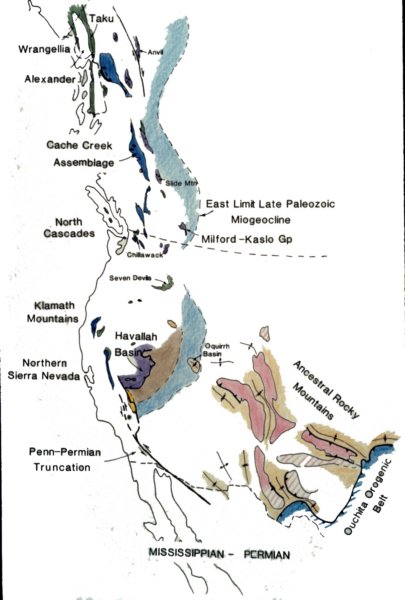

We now leave the Antler behind and consider the Mississippian-Permian time in western North America. We will discuss the Havallah Basin, the Ancestral Rockies and the Truncation fault at the southern end of the Passive Margin. ----------------------------------- The Havallah sediments, deposited in a distal marine basin, were a lot like the Antler sediments before they were thrust over the western edge of North America. In the Permian, these marine sediments were thrust up and over the western edge of North America, overlapping the rocks of the Antler Orogeny. No oceanic crust in found in either the rock of the Antler or the Havallah Orogenies. The sediments could have been scraped off a down-going plate like in Accretionary wedges. The difference between the two events is that the accretion of the Havallah basin sediments was driven by an Island Arc pushing from behind. The island arc emplaced west of the Havallah sediments had an accretionary wedge on its western edge that contains marine sediments that range in age between Cambrian and Permian. These accretionary wedge sediments, called the Cache Creek Assemblage contain a fossil assemblage that is not of North American but rather of Asian affinity. This fossil evidence suggests that the Arc originated close enough to Asia to subduct a large proportion sea floor that had Asian sediments on it. We know that the Havallah basin was close to North America as its fossils are of North American affinity. Some workers debate whether the Havallah basin did not directly collide with North America, but rather was transported laterally into position along large transverse faults like those found on the South Island of New Zealand today. ------------------------------ An onlap sequence of sediments of Triassic age cover the Havallah and Antler rocks, demonstrating that the mountains created by these accretionary events were eroded away and subdued enough to have shallow marine rocks deposited over them. ----------------------------- The sequence of events we have discussed up to this point create a distinctive stratigraphy along the western edge of north America stretching from somewhere south of California all the way to Alaska. This sequence is (1) the passive margin sediments deposited during the period of rapid subsidence, (2) the passive margin sediments deposited during the period of slow margin subsidence, (3) the Antler Orogeny, (4) the accretion of the Havallah Basin sediments and (5) the accretion of the island arc and its associated accretionary wedge. In the late-Pennsylvanian, early-Permian, it is believed that a large transverse (left-lateral strike-slip) fault trending NW-SE truncated this sequence of rocks, shifting the southern part into Sonoran Mexico. This is called the North American Megashear hypothesis and is widely debated among geologists. This feature has a large influence on the resulting tectonic history of the region we will be mapping during winter break. ------------------------------- At the same time that the Megashear may have been active, the Ancestral Rockies were actively being uplifted. These basement-cored uplifts deposited sediments into adjacent basins that now are some of the largest petroleum reserves in North America. These uplifts are called the ĎAncestral Rockiesí because these same rocks and styles of deformation would occur much later in time when the modern Rockies were created. Many debate why the uplifts happened. Some suggest that compression from when Havallah, Antler and Arc materials were accreted from the west, there was also compression from the south east from the Ouchita Orogenic event. The problem with this is that the orientation of all the Ancestral Rockies uplifts are perpendicular to the orientation you would expect from the directions the stress was coming from. Others have suggested that these features were created by large strike-slip faults. We wrote a paper some time ago suggesting that the edge of the continental margin was continuous between the Havallah and the Ouchita and that compression came from the southwest, coincident with the orientation of the deformation in the Ancestral Rockies. The problem is that the evidence for this compression has now been shifted along the truncation fault and is no longer in the appropriate position.
Created with Web Album Generator