STISIM Drive
(SDL) - ROAD - Road Parameters
The ROAD event displays the
simulation roadway allowing the experimenter to specify a variety of different
roadway attributes. The default roadway (if no ROAD event is used) consists of
a single lane of traffic in each direction, a dashed line separating the 2
lanes, and no edge lines. The lanes are 12 feet wide and the center stripes are
10 feet long and .3334 feet wide with a 10 foot spacing between the lines. It
is recommended that if you will be using the ROAD event, it should appear as
the first line in your events file, thus starting the simulation with the
roadway you desire. You can then change the roadway later on in your scenario
by activating another ROAD event.
In older versions of STISIM
(DOS based versions) you could only specify attributes for the roadway lanes.
With STISIM Drive, you can now specify some additional roadway parameters such
as shoulder width, foreslope, and roadway cross-slope. These along with the VC
(Vertical Curvature) event allow you to generate
three dimensional roadways. The new parameters are numbers 11 through 21 and
are optional. If you do not specify parameters 11 through 21 they will be
ignored and the roadway will look similar to roadways generated by STISIM.
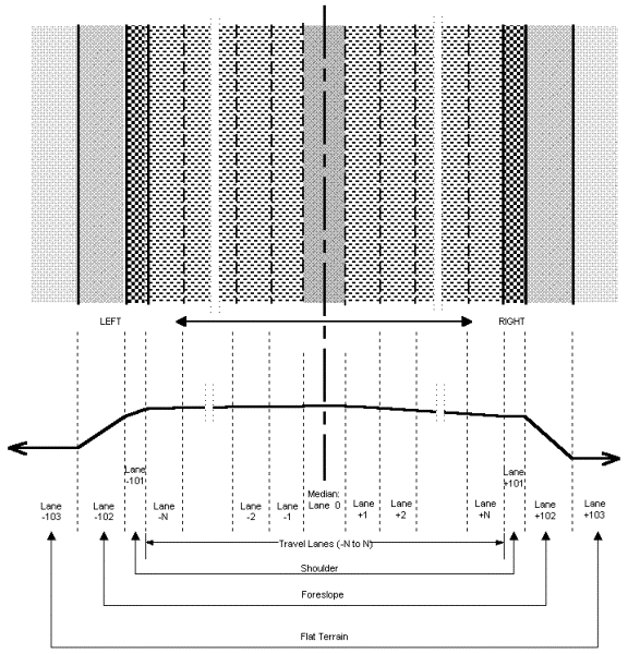
One other caveat of the roadway that you should know about deals with the roadway center line. The roadway that you display can have traffic flowing in both directions separated by some roadway striping (total # of lanes does not equal # of right hand lanes), or you can have roadways with traffic heading in only 1 direction (total # of lanes equals # of right hand lanes). Add to this that the number of lanes on the left and right do not have to be equal, and there are numerous roadway possibilities. Because of all these possibilities, the lateral position of most events is defined with respect to the roadway’s dividing line. The roadway dividing line is defined as the lateral position on the road where the right hand lanes and left hand lanes meet. For roadways with traffic in both directions, the roadway dividing line is the center stripe. For roadways where the traffic is only heading forward, the roadway dividing line is defined as the left edge of the roadway.
Some important facts to remember when designing your roads:
Always include some cross
slope in the roadway lanes, shoulders and foreslopes. This will make the
roadway display better. If you do not include some cross slope, the graphics
engine has trouble distinguishing between the ground and the roadway elements
and this can cause the roadway display to breakup and look funny.
Changing roadways attributes too close together is not a good idea. Since the roadway is essentially generated on the fly, the program sometimes has trouble distinguishing between roadway attributes when they are changed too quickly. There is no magical distance that should be used, you will have to use visual verification.
EVENT PARAMETERS:
|
PARAMETER 1: |
Width, in feet, of each roadway lane. All of the lanes no matter what direction the traffic is heading will have the same widths. |
|
PARAMETER 2: |
Total number of lanes that will be displayed for the desired roadway. This total includes all lanes traveling in both directions. |
|
PARAMETER 3: |
Total number of right hand side lanes. This total only includes lanes that will appear to the right of the roadway’s dividing line. |
|
PARAMETER 4: |
Roadway’s dividing line
striping option (the color for these lines is specified with the "Set
Simulation Colors" and "Assign Simulation Colors" options,
found in the "Options" menu. 0 - No dividing line is
displayed |
|
PARAMETER 5: |
Edge line flag. If this parameter is 0, then no edge lines will be displayed, otherwise the value that is used specifies the distance, in feet, from the edge of the roadway to the inside edge of the edge line. |
|
PARAMETER 6: |
For cases when the lane markers are stripes, this parameter specifies the length, in feet, of the stripes that will be displayed. |
|
PARAMETER 7: |
For cases when the lane markers are stripes, this parameter specifies the longitudinal distance, in feet, between the end of one stripe and the beginning of the next stripe. |
|
PARAMETER 8: |
Width, in feet, of the lane division markers. This parameter effects the widths of the dividing line markings and any lane marking between lanes headed in the same direction. |
|
PARAMETER 9: |
Width, in feet, of the edge lines, if they will be displayed on the roadway. |
|
PARAMETER 10: |
Transition length, in feet, to change from previous ROAD event. The ROAD width will linearly change over the transition length. |
|
PARAMETER 11: |
Cross-slope for the right hand side travel lanes, in percent grade (100 * feet/feet). All of the lanes on the right hand side of the road will have this cross-slope. Negative values for the cross-slope mean that the road is sloping down as you go from the centerline to the roadway's outer edge. |
|
PARAMETER 12: |
Cross-slope for the left hand side travel lanes, in percent grade (100 * feet/feet). All of the lanes on the left hand side of the road will have this cross-slope. Negative values for the cross-slope mean that the road is sloping down as you go from the centerline to the roadway's outer edge. |
|
PARAMETER 13: |
Cross-slope of the right hand side shoulder, in percent grade (100 * feet/feet). Negative values for the cross-slope mean that the road is sloping down as you go from the centerline to the roadway's outer edge. |
|
PARAMETER 14: |
Width, in feet, of the right hand side shoulder. |
|
PARAMETER 15: |
Cross-slope of the left hand side shoulder, in percent grade (100 * feet/feet). Negative values for the cross-slope mean that the road is sloping down as you go from the centerline to the roadway's outer edge. |
|
PARAMETER 16: |
Width, in feet, of the left hand side shoulder. |
|
PARAMETER 17: |
Slope of the right hand side foreslope, in percent grade (100 * feet/feet). Negative values for the slope mean that the road is sloping down as you go from the centerline to the roadway's outer edge. |
|
PARAMETER 18: |
Width, in feet, of the right hand side foreslope. |
|
PARAMETER 19: |
Slope of the left hand side foreslope, in percent grade (100 * feet/feet). Negative values for the slope mean that the road is sloping down as you go from the centerline to the roadway's outer edge. |
|
PARAMETER 20: |
Width, in feet, of the left hand side foreslope. |
|
PARAMETER 21: |
Width, in feet, of the center median. The center median will always be flat and symmetric about the roadway center line as shown in the roadway figure. |
EXAMPLE:
0,ROAD,12,2,1,3,.5,10,10,.333,.333,0,-1,-1,0,6,0,6,-5,10,-5,10,0
In the ROAD example shown,
the roadway that is described will be shown as soon as the simulation run
starts, this is because the ON DISTANCE parameter is set to 0. The
roadway will consist of 2 12 foot lanes, one on the right and one on the left
(12,2,1). Since there will be traffic flowing in both directions, a center
stripe is needed. In this example the center stripe is a solid line on the left
and a broken or dashed line on the right (3). Since parameter 5 is set to
.5, edge line striping will occur .5 feet in from the edge of the roadway. The
length of the lane markings and the distance between them are specified with
parameters 6 and 7 respectively. For this example the lane markings are 10 feet
long and are separated by 10 feet. Since this roadway has both lane markings
and edge lines, the width of these lines must be specified. In this example the
line widths are set to .333 feet each using parameters 8 and 9. Parameter 10
specifies the transition distance if one roadway definition is being replaced
by a newer definition. Since this roadway event is established at the start of
the run, no transition distance is necessary and parameter 10 is set to 0.
Hopefully we haven't lost
just yet. So far we have just explained the normal roadway parameters, however
in our example there are also some vertical parameters that we are interested
in setting. The cross-slopes for the both the left and right hand lanes will
slope down 1 percent from the center line to the roadway edge lines because
they are both specified as -1. This means that the roadway edgeline will be .12
feet lower than the roadway center line (.12/12=.01 x 100 = 1 percent and
negative values mean it slopes down). There will be no right or left shoulder
cross-slopes because these parameters are set to 0, and the shoulders are 6 feet
wide (0,6,0,6). Just past the shoulders there will be 10 foot wide foreslopes
that have 5 percent grades sloping downward (-5,10,-5,10). Finally, since the
final parameter shown is set to 0, no median will be displayed in the roadway.