Two if by Sea
ArticlesProfileTreasure ChestArchivesHome


Archives: Spring 2002 Table of Contents
Listening for Hurricanes from the Sea Floor

by Andrea Cohen, MIT Sea Grant

Interested 
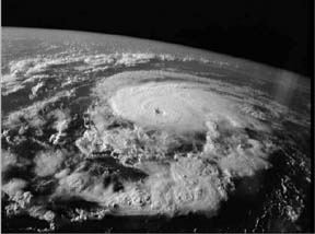
in figuring out just how dangerous a hurricane might be? All you need is a sense of adventure, a bit of expertise, and a P3 Orion plane to pilot directly into the eye of the storm. Well, it's not for everybody, but this dramatic method is in fact currently the best way to measure the maximum wind speed of a hurricane, and thus its potential risk to humans. It's also an expensive maneuver that developing countries—often the hardest hit by hurricanes and tropical cyclones—can ill afford.
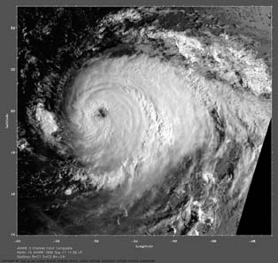
Nicholas Makris, an associate professor in MIT's Department of Ocean Engineering, thinks there may be another, cheaper, less harrowing method–one that takes advantage of the fact that sound waves can propagate useful information for hundreds of miles beneath the ocean's surface. "This capacity of the ocean as a sonic information channel has been exploited by scientists for decades and by fish and marine mammals for millennia," he says.

So it's not surprising that in a conversation about ambient noise in the ocean with world hurricane expert Kerry Emanuel, professor of meteorology in MIT's Department of Earth, Atmospheric, and Planetary Sciences, the two discussed the possibility of detecting hurricanes by measuring sound. That conversation led to their current project, exploring how hydrophones deployed in the ocean might gather acoustic data and provide critical information about hurricanes. The project is supported by MIT Sea Grant and the Office of Naval Research.

Hurricane Gert
Hurricane Gert attained a category 4 status in its September 1999 travel from the coast of Africa to Newfoundland. Photo credit: Ocean Remote Sensing Group, John Hopkins University Applied Physics Lab.

Satellite imaging technology is a reliable means of detecting and locating hurricanes. However, even with satellite images, says Makris, assessments of a hurricane's destructive power are off by at least an order of magnitude, with scientists crudely estimating wind speeds. Those estimates lead to critical decisions about evacuating coastal communities. An unnecessary evacuation can mean millions of dollars in lost revenue; and the lack of evacuation when a deadly storm strikes means the loss of lives, in addition to the destruction of property.

However, single hydrophones or acoustic arrays placed strategically could record the sound associated with high winds and provide accurate information about a hurricane's power. Makris likens acoustic arrays to an acoustic eye or radar dish. "It's like a lens or a telescope that allows you to see in one direction and to discriminate other directions," he says. "A typical hydrophone array might be comprised of a line of roughly 128 acoustic sensors separated at 1/2 the acoustic wavelength. In the 300-Hz range, where wind-wave noise starts to become dominant in the ocean, the wavelength of sound is roughly five meters, so acoustic arrays typically span a couple of hundred meters for this frequency," he explains.

When the aperture is in a horizontal mode, it discriminates the location horizontally; the same can be done for a vertical orientation. Makris explains: "When you pluck a guitar string in the middle it's got a mellower tone than if you pluck it at the ends. It has to do with the modes of vibration of the guitar string. The ocean's like a guitar, and depending on where you pluck it, you get different kinds of modes."

To prepare for recording actual hurricanes, Makris and graduate student Josh Wilson have developed a model that they’ve applied to areas of the world where hurricanes are a problem, such as in the Bay of Bengal. The researchers have also begun collecting existing underwater acoustic data from the U.S. Navy’s SOSUS underwater listening stations. These bottom-mounted acoustic arrays were originally used during the Cold War to find Russian submarines and provide a record of all the natural and unnatural sounds in the ocean. "We can track humpback whales vocalizing in Greenland with SOSUS stations in Bermuda–from one end of the ocean to the other," notes Makris. "A humpback whale has far less source power than a hurricane, so if you can track a humpback whale, you should be able to track a hurricane. We plan to use the data collected from SOSUS stations to see if we can acoustically track and classify these hurricanes."

Satellite Imaging of a hurricane
Satellite imaging technology provides a robust means of detecting and locating hurricanes but is less successful at assessing destructive forces.

The researchers also plan to make measurements of their own by deploying an autonomous underwater vehicle (AUV) during a hurricane in, say, waters off the west coast of Florida, or in the Yucatan. The AUV would be sent to the ocean floor—out of the hurricane's way—to make one single-point measurement at various frequencies with the storm arriving overhead. "No one has ever measured the ambient noise level versus wind speed beyond about 30 knots in the ocean," notes Makris. "It just gets too rough and people stop taking data or the equipment breaks." He also explains that the intensity of underwater noise increases with the cube of the wind speed, at speeds below 30 miles. This suggests that a similar relationship would exist in hurricane conditions. By separating the hurricane noise from the general bubbly noise of the ocean, and by discriminating the direction of the hurricane, Makris hopes to discern the storm’s power.

Before heading too far afield, the researchers look forward to testing an ambient noise acquisition system in local waters. And those tests suggest other benefits to the technology. "Getting all these ambient noise measures as a function of location in the Charles River and in Boston Harbor will be very valuable," says Makris. The tests, for instance, could help establish definite correlations between marine mammal populations and noise pollution in coastal waters—a topic that has been its own maelstrom in recent years.


Return to Top