| |
Archives:
Spring 2002 Table
of Contents
The Challenges of Managing an Evolving Shoreline
by Tracey Crago, WHOI Sea Grant
The Massachusetts
shoreline spans 1,500 miles, with beaches covering nearly two-thirds
of that distance. The changing nature of that coastline poses a
challenge to all who enjoy it: recreational users, waterfront property
owners, regulators, lawmakers, and those who derive their livelihoods
from the sea. In a perfect world, the entire shoreline would be
managed as one. In reality, the shoreline is segmented by many boundaries—property
lines, town lines, state lines, coastal landform features—all
presenting management challenges and inconsistencies.
Given those challenges, how are we doing when it comes to managing
the Massachusetts shoreline? WHOI Sea Grant, through its coastal
processes program, decided to investigate. Graham Giese, coastal
geologist, and former Sea Grant extension agent, began by looking
at outer or open ocean shorelines, sheltered shorelines (bays and
estuaries), and developed shores. He considered the techniques used
for managing each type of shoreline—and their effectiveness—
to get a sense of our progress.
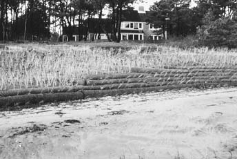 |
Non-structural
erosion control alternatives range from simple plantings to
complex scenarios like that pictured here, involving the re-grading
of a coastal bank, addition of fill material, a covering of
biodegradable netting and coir logs—all blanketed with
coastal plants.
Photo credit: Jim O'Connell, WHOI Sea Grant. |
Giese found
that the management techniques used for different types of shorelines
were not necessarily the same. Jim O’Connell, now coastal processes
specialist for WHOI Sea Grant, picked up the project after Giese
retired. During a 1997 workshop titled "Coastal Landform Management
in Massachusetts," participants were asked to consider the
state’s successes and failures in sustaining the beneficial
functions of coastal landforms. The result? "Qualitatively,
we are doing a decent job of trying to maintain a delicate balance
of preserving landforms for future generations while allowing property
owners ‘reasonable uses’ of their private property,"
explains O’Connell.
That workshop, he says, led to the coastal landform sustainability
project, which set out to quantify opinions of the ‘how are
we doing’ question by analyzing actual orders of conditions
(permits) granted at the town level. The study documented permitted
activities that took place on and adjacent to coastal landforms,
and their potential effects on coastal landform function. All 15
towns on Cape Cod were involved in the one-year project, in which
319 projects involving 56 separate activities were reviewed and
‘rated’ in a sustainability rubric developed by Giese
and carried out by personnel from the parti-cipating towns, with
assistance from WHOI Sea Grant.
"Based on that 1999 exercise, we concluded that we are not
maintaining the beneficial functions of coastal landforms,"
says O’Connell. "While science should be the underpinning
of all coastal management, tradeoffs and balances are often necessary
when applying performance standard-based regulations that govern
activities on coastal landforms." Thus the second WHOI Sea
Grant workshop, held in 2001: "Can Humans and Coastal Landforms
Co-exist?"
Aimed at individuals actively engaged in planning, managing, regulating,
engineering, education, and scientifically investigating coastal
landforms and their beneficial functions, the workshop had a very
applied focus. Attendees looked at case studies documenting the
interactions between coastal landform functions and human activities.
Analyses of the effects of activities and comparisons of alternative
construction practices were also provided through an interactive
dialogue.
"What became obvious," says O’Connell, "is that
we possess a reasonably thorough qualitative understanding of the
critical characteristics and beneficial functions of coastal landforms;
however, our quantitative understanding and predictive capability
to determine the effects of human activities on coastal landform
function on a lot-by-lot basis is still evolving."
A third workshop, held in March 2002, began from the reality that
management involves both science and human values. Titled "Stabilizing
Dunes and Coastal Banks Using Vegetation and Bioengineering,"
the workshop had a practical focus, posing the following questions
to speakers and participants: are there ways to improve coastal
landform management in Massachusetts? Is there a middle ground?
Do bioengineering and the use of coastal plants, as erosion control
measures, work? What are the economics of bioengineering and plant
control? By the end of the day, participants had learned about bio-
and photodegradable materials, their aesthetic and functional values,
and the use of native plants for coastal stabilization in a variety
of scenarios. The general conclusion, says O’Connell, is that
these measures "won’t stop erosion, but they can slow
it in certain areas. The caution," says O’Connell, "is
that in slowing erosion, adverse impacts will continue—loss
of material for beaches and saltmarshes, for example—but such
measures represent a good compromise."
O’Connell believes that such non-structural alternatives are
becoming the accepted norm for planning and regulatory purposes.
From a cost standpoint, bioengineering and vegetative alternatives,
or a combination of both, are less expensive or comparable to ‘hard’
alternatives (groins, jetties, armoring techniques). What remains
to be seen is the long-term viability of bioengineering projects,
and the amount, frequency, and associated cost of maintenance for
each scenario.
WHOI Sea Grant and the U.S. Geological Survey recently completed
a study for Massachusetts Coastal Zone Management to update, map,
and analyze historical shoreline changes in Massachusetts using
GIS, aerial photographs, and historic shoreline data. The maps,
along with a user guide, will soon be released by MCZM to assist
towns in planning purposes. "All shorelines exhibit trend reversals—an
erosion phase followed by an accretion phase and vice versa—because
no shoreline is truly stable," explains O’Connell. "These
maps are based on four to five snapshots over a 150-year period.
A lot can happen in between that may not be captured by the maps."
That is where the user’s guide will be of greatest value, says
O’Connell. "Extreme caution should be used when using
long-term shoreline change data." The maps and accompanying
data, he says, "have the potential to improve decisions about
coastal management, residential and commercial development, and
coastal research, by making the shoreline data comprehensible."
For more information about the shoreline change maps, user’s
guides, or any of the WHOI Sea Grant workshops described here, contact
Jim O’Connell at joconnell@whoi.edu or by calling (508) 289-2993.
Return
to Top
|