|
Archives:
Summer 2000
Table of Contents New England fishermen accustomed to hauling in cod and flounder may soon find themselves with a new, valuable–if non-edible–catch: scientific data. Both fishermen and researchers rely on oceanographic and meteorological reporting to perform their jobs, and both agree that the Northeast waters suffer from a dearth of data needed for such forecasting. So, in a project funded by the National Oceanographic Partnership Program (NOPP), several fishermen are now having their boats outfitted with instruments to gather information and transmit it back to shore in real-time fashion. The project, called FleetLink, is a collaborative effort involving researchers from MIT Sea Grant, New Hampshire Sea Grant, WHOI, and Clearwater Instrumentation, Inc. of Watertown, Mass.
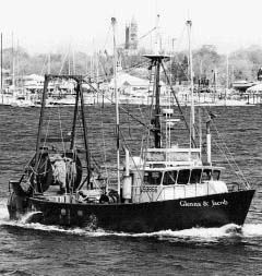
"There is a need for much better information on weather, sea-state, oceanographic conditions, commercial harvest data, and fishing conditions in the coastal waters of the United States," says Ann Bucklin, director of New Hampshire Sea Grant and the principal investigator for the project. Fishermen, resource managers and regulators, and the oceanographic research community all rely on such information, which is currently collected during oceanographic research efforts, National Marine Fisheries Service (NMFS) assessment surveys, operational Navy activities, and National Weather Service coverage. However, she explains, these kinds of activities cannot provide synoptic coverage of large regions and rarely use near-real-time telemetry. Conversely, the widespread temporal/spatial distribution of commercial fishing vessels makes them ideal platforms from which to gather basic information for coastal monitoring, modeling, and prediction. And, notes Bucklin, compared with other coastal ocean observing systems, fishing vessels have the advantage of mobility, flexibility, and concentration in regions of highest human usage, where weather data are most needed. Up until now, with limited cooperation between the fishing community, government agencies, and the ocean research community, fishing vessels have been little used in gathering data. This project aims to change that, says Cliff Goudey, director of MIT Sea Grant's Center for Fisheries Engineering Research(CFER), which has led the hardware integration and software development for the project. "It's really a win-win situation," states Goudey. "The National Weather Service and other forecasters need better data, and fishermen need better weather forecasting." The challenge, he says, was figuring out how to turn fishing boats into reliable scientific reporting platforms. A key component, says Goudey, was designing a system that would operate independently of fishermen, allowing them to concentrate on their fishing. "You're not going to turn fishermen into a fully functional weather station," he concedes, "but there are things that can be measured with sensors. By putting a suite of highly accurate sensors on a boat and transmitting that information back to shore, they can be working as fully functional observatories without the fishermen even having to get involved." These meteorological sensors are of the same type that would be found on a NOAA weather buoy and measure sea-surface temperature, wind direction and speed, temperature, humidity, and barometric pressure. One particularly unique sensor is attached to fishing gear and moves up and down with the nets, recording temperature vs. depth much like the sensors that a research vessel would use when trying to get deep water temperatures. When the gear and sensor return to the surface, the data is immediately transferred by a radio link to the onboard FleetLink hardware for processing and transmittal to shore. Thus far, the researchers have outfitted Craig Pendelton's boat, the Susan and Caitlin, out of Portland Maine. While at sea, the vessel continuously collects meteorological data, which is relayed hourly, via satellite, to COMSAT, a global satellite communication system. COMSAT, in turn, sends the information, via email, to Bob Groman, an information systems specialist at the U.S. GLOBEC Georges Bank Program at WHOI. Groman can then send weather information to the National Weather Service. FleetLink also allows captains to record their catch data by species and pounds. For now, this data is turned into a Hail Report that Groman forwards to the Portland Fish Exchange, where Pendleton's dragger normally sells his fish. "Such detailed Hail Reports really help the exchange and the boat owner get top dollar for their fish", says Goudey. "Ultimately, all of us involved in the project hope that the real-time catch data available through FleetLink will also allow better, more responsive fisheries management." Though the system is still under development, a second boat, the Glenna and Jacob, of Fairhaven, Mass., is about to join FleetLink. Owner Bob Kohl trawls for groundfish and will broaden FleetLink's coverage. A third vessel will complete the initial pilot installations. "Once we get all three boats up and running," explains Goudey, "there's a fair chance that we'll have a continuous presence out there." For the fishermen, who are keen on getting better forecasting, the opportunity to outfit their boats with better instrumentation and communication tools also positions them to get involved with further fisheries research. And the project has also demonstrated other ways that improved communication can help fishemen. For instance, with FleetLink, in addition to a fisherman being able to report catches to shore, a vessel’s broker can keep the boat up to date on fish price fluctuations. In this way, a boat can avoid targeting a species for which the demand has suddenly dropped. Both Goudey and Bucklin are optimistic that FleetLink will result in a better, largely automatic, and near real-time method of reporting offshore weather, climate, ocean, and fisheries data for use by a wide variety of communities. And in doing so, it should also bring together oceanographers, private entrepreneurs, fishermen, and federal agency representatives in a new spirit of cooperation.
|