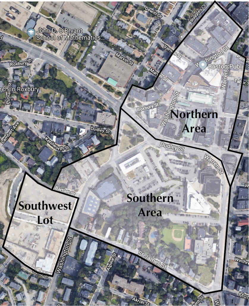
 Figure 1: Site Boundaries Map. Base map from Google Maps. Map. 2018. Accessed April 18, 2018. https://www.google.com/maps/@42.3286406,-71.0864285,828m/data=!3m1!1e3.
The Dudley Square site has undergone significant changes over the course of the 19th and 20th centuries which have not only completely redefined its landscape, but also reveal broader regional and national processes. In some ways, the site serves as a microcosm of the United States' major changes in transportation modes, the effects of the Great Depression on urban life, and urban renewal projects of postwar years. However, in other ways, Dudley Square serves as an exception to these processes: it held on to elevated rail and streetcars longer than most cities and its urban renewal was community-led. Although Dudley Square has always been and today remains a transportation hub, the modes of transportation that serve it have followed the national shifts from horses to urban rail transportation to automobiles. The changes in physical landscape and land uses on the site have corresponded to these broader shifts. Each period of prevalence of a particular mode of transportation has imparted on the site a specific set of physical infrastructures along with land uses. Thus, the site demonstrates the ability of transportation to radically transform urban form and land use, as well as the powerful influence of socioeconomic and political processes on cities.
1885: Horse Transportation and Commercial Center
 Figure 2: Annotated Site Map 1885. Base map from "Roxbury, West Roxbury, and Parts of Brighton and Brookline." Map. In Sanborn Fire Insurance Maps: Greenwich, Fairfield Co. Vol. 3. Teaneck, NJ: Sanborn Map, 1885.
The earliest detailed maps of the site establish the Dudley Square site as a center for horse transportation. Figure 2 shows a cluster of stables in the northern part of the site. The cluster suggests that Dudley Square was a transportation center, likely serving the adjacent commercial buildings. The southwest lot, containing streetcar houses and horse stables, reveals the presence of a horse-drawn system. In Crabgrass Frontier, Kenneth Jackson describes the gradual adoption of public transportation in North America, first in the form of the horse-drawn omnibus—operating in Boston as early as 1835—followed by horse-drawn cars on rails—replacing the omnibus in Boston by 1860 . This horsecar system is likely the reason for the quantity of development the site already had at the end of the 19th century despite it not being in the center of Boston. As Jackson points out, the creation of horsecar lines led to increased property values on adjacent lots and new construction, thus extending the built-up area of cities . Although it is impossible to tell from Figure 2 if horsecar lines were created to serve Dudley Square or if Dudley Square was densified as a result of new transit, it is certain that the two processes went hand in hand. The prevalence of horse transportation in 1885 is further revealed by the "carriage manufactory"—likely producing carriages for horsecar lines or for private use—located just north of the stable cluster as well as the many stables located next to homes or other commercial lots, especially in the southern part. Dudley Square's importance as a transportation and commercial center is also shown by the six hotels present all over the site. As described in Crabgrass Frontier, hotels in the 19th century were centers for business and informal meetings. They were also usually found at the heart of business districts , leading to believe that Dudley Square was one of the commercial cores at the scale of the city of Boston. The prevalence of horse transportation left a distinct mark on the form and land uses of the site.
1885-1899: The Shift from Horses to Streetcars and Densification
 Figure 3: Annotated Site Map 1899. Base map from Bromley, George W., and Walter S. Bromley. "Roxbury." Map. In Atlas of the City of Boston. Philadelphia, PA: G.W. Bromley and Company, 1899.
Despite a strong initial presence, horse transportation on the site quickly declined after the creation of an elevated rail and electric streetcar station at Dudley Square following the widespread adoption of electrified rail transit in cities across North America and the world. This rail transfer station first appears in Figure 3, a map from 1899. The stable cluster, residences, and carriage manufactory have been cleared for a multi-level, double-looped transfer station between the elevated rail line continuing north to central Boston along Washington Street and the "surface cars" or electric streetcars extending south of the station. This radical shift in transportation modes, from slow, costly, and inconvenient horses to fast, inexpensive, and efficient electric transportation occurred in the context of major technological advancements brought about by the Industrial Revolution. The electric streetcar was also a product of an American culture prioritizing outward settlement with less density over staying close to the core of a city. The greatly increased traffic and property values around the station were certainly the drivers of the densification and changes of land use on the site in conjunction with the installation of the rail station. Figure 3 shows new multi-family residential development on previously single-family lots along Washington Street in the southern part. Industrial uses have also disappeared from the site, likely owing to the demand for commercial space stemming from profitability of businesses so close to major transit stations. The notable decrease in stables marks the permanent transition away from horse-drawn transportation modes, thus demonstrating the dependency of land use changes on changes in transportation modes.
1899-1931: Department Stores and the Great Depression
 Figure 4: Annotated Site Map 1931. Base map from Bromley, George W., and Walter S. Bromley. "Roxbury." Map. In Atlas of the City of Boston. Philadelphia, PA: G.W. Bromley and Company, 1931.
A larger jump into the future reveals an ever-shifting transportation landscape as automobile infrastructure starts to appear bit by bit as well as the stimulating effect of transportation centers on businesses. In Figure 4, a map from 1931, a close look at the businesses surrounding the station reveals that many are department stores. In fact, according to Jackson, department stores were developed in conjunction with the expansion of streetcars and rail transit. Their locations at the intersections of the busiest transit lines ensured ample foot traffic and visibility . However, this affirmation of rail transit is threatened: as seen in Figure 4, a few garages are appearing within the site and just outside it, signaling the coming rise of automobiles. Though transportation has had a long-lasting impact on the site, some changes are best explained by the broader social and economic context of the 1930s: the Great Depression. The effect of the Great Depression on the site is best observed in the increase in multi-family residences. While in another context, this could seem like new construction and densification, a closer look reveals that these residences are simply single-family residences that have been converted to house more people. This process follows the trend that Jackson describes in which multiple families shared a previously single-family home during the Great Depression in the midst of a severe housing shortage and income decrease . The action of socioeconomic processes is another one of many processes shaping cities.
1931-1974: Buses, Automobiles, and Urban Renewal
 Figure 5: Annotated Site Map 1974. Base map from "Boston, Massachusetts" Map. In Sanborn Fire Insurance Maps: Greenwich, Fairfield Co. Vol. 3. Teaneck, NJ: Sanborn Map, 1974.
Although the rise of automobile use starts to affect the site in 1931, postwar years mark more important automobile-related changes as well as the adoption of buses. The increased adoption of automobiles is reflected by an increased presence of parking lots. There is even one located adjacent to the elevated rail station, a lot which, due to its proximity to transit, would likely be valuable. This juxtaposition points to the growing prevalence of automobiles and decline of public transportation. Nonetheless, the site retains its elevated rail station, a sign that rail transportation persisted for longer here than many cities. A look at Figure 5, a map from 1974, reveals that while the transfer station remains, one of the two streetcar turnaround tracks has been converted for bus use. Although buses were used to replace streetcars on the outskirts of Boston as early as 1925 , this map shows the first evidence of a bus system serving Dudley Square. The southwest lot on the site also reflects the shift to buses as it now serves as a bus garage. As described in Crabgrass Frontier, the conversion of electric streetcars to buses in the United States was often a result of (fraudulent) action from automobile manufacturers, such as General Motors, which also supplied buses . The fact that one of the two original streetcar tracks and the elevated rail station remain speaks to Dudley Square's lasting importance as a transportation center resisting the total conversion to buses as seen in cities such as Los Angeles. While the northern part of the site is most affected by these changes in transportation, the southern part of the site is a target of postwar urban renewal and is almost entirely demolished to make way for public buildings. This striking change is apparent in Figure 5, especially when compared with Figure 4. The former street network comprised of Cliff Street, Dana Street, Glenwood Street, and a few cul-de-sacs is replaced by a single large block. What was once a mix of residences and businesses is now a Boy's Club, a courthouse, and a police station. The only buildings that remain from before the demolition is the row of single-family homes along St. James Street. The reconstruction of the southern part of the site was part of the broader Washington Park urban renewal plan led by the Boston Redevelopment Authority. Although urban renewal in 1960s America was often top-down and destructive for communities, urban renewal in Roxbury actually involved the community to develop a plan as is shown in a short book from 1963 detailing the Boston Redevelopment Authority's proposal . This establishes Dudley Square and Roxbury as a striking counter-example to Boston's previous brutal urban renewal projects.
1974-1992, 2016: The End of the Elevated Railway and the Total Adoption of Automobiles and Buses
 Figure 6: Annotated Site Map 1992. Base map from "Boston, Massachusetts" Map. In Sanborn Fire Insurance Maps: Greenwich, Fairfield Co. Vol. 3. Teaneck, NJ: Sanborn Map, 1992.
By the end of the 20th century, the elevated rail and streetcar systems, once the key characteristics of Dudley Square, have disappeared to make way for a bus system. A look at Figure 6, a map from 1992, shows that the elevated rail and streetcar transfer station has been demolished and has been replaced by a bus station. By 1992, the elevated rail system no longer exists, thus marking a complete transition from transportation modes popularized during the turn of the 19th century to automobiles and buses, modes very much belonging to the 20th century. In this regard, the site is unusual in the context of the United States in that its urban rail transportation existed for so long. The further increased presence of parking lots indicates an even more prevalent use of automobiles, thus confirming the total shift in transportation modes.
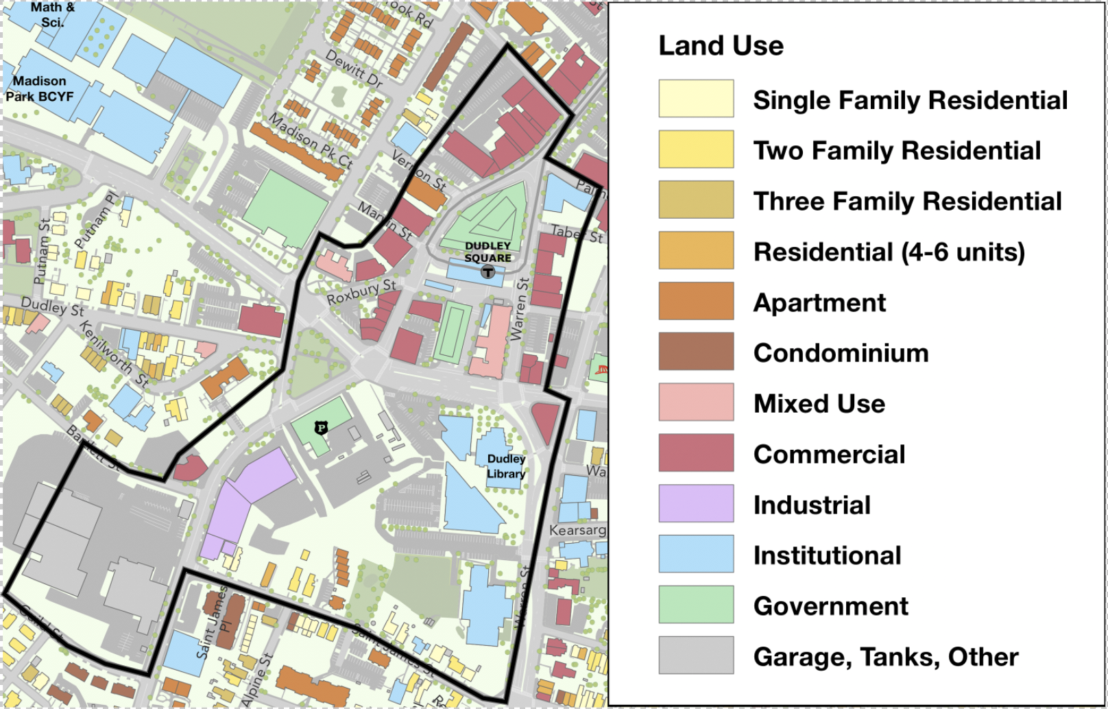 Figure 7: Site Land Use Map 2016. Base map from "Map of Roxbury Neighborhood." Map. Boston Planning and Development Agency. November 2016. Accessed April 18, 2018. http://www.bostonplans.org/3d-data-maps/maps/neighborhood-maps?page=2.
A present-day map (Figure 7) differs little from the 1992 map, except for the creation of a new road, Malcolm X Boulevard. This new wide boulevard is built over the former western part of Roxbury Street and feeds directly into Dudley Street, creating a triangular park between itself, Washington Street, and Shawmut Ave. Although the reason for its creation is unclear, the boulevard is an addition to the site's automobile infrastructure, thus re-emphasizing the dominance of automobiles in urban transportation today.
Conclusion
Cities are complex systems and their change through time depends on the layering of seemingly independent processes. Urban form is precisely the manifestation of the simultaneous interaction between all of these processes. Often times, these processes occur on a scale broader than a single neighborhood or city, but rather, a region or country. In the case of the Dudley Square, the site exemplifies some national processes, such as the shift from horse transportation to rail transportation to automobiles or the conversion of single-family homes to multi-family homes during the Great Depression. Other times, the site serves to contradict more general trends, such as the persistence of the elevated rail station well past the widespread adoption of automobiles or the site's community-driven urban renewal. When studying and planning cities, it is imperative to consider a broad cross-section of social, economic, political, and technological processes in order to fully grasp both historical changes and future plans.
Bibliography
Text: Collins, John F. Your New Washington Park: A Bold Program in Urban Renewal. Boston, MA: Boston Redevelopment Authority, 1963. Jackson, Kenneth T. Crabgrass Frontier: The Suburbanization of America. New York: Oxford University Press, 1985: 33-35, 39 Images: Google Maps. Map. 2018. Accessed April 18, 2018. https://www.google.com/maps/@42.3286406,-71.0864285,828m/data=!3m1!1e3. "Roxbury, West Roxbury, and Parts of Brighton and Brookline." Map. In Sanborn Fire Insurance Maps: Greenwich, Fairfield Co. Vol. 3. Teaneck, NJ: Sanborn Map, 1885. Bromley, George W., and Walter S. Bromley. "Roxbury." Map. In Atlas of the City of Boston. Philadelphia, PA: G.W. Bromley and Company, 1899. Bromley, George W., and Walter S. Bromley. "Roxbury." Map. In Atlas of the City of Boston. Philadelphia, PA: G.W. Bromley and Company, 1931. "Boston, Massachusetts" Map. In Sanborn Fire Insurance Maps: Greenwich, Fairfield Co. Vol. 3. Teaneck, NJ: Sanborn Map, 1974. "Boston, Massachusetts" Map. In Sanborn Fire Insurance Maps: Greenwich, Fairfield Co. Vol. 3. Teaneck, NJ: Sanborn Map, 1992. "Map of Roxbury Neighborhood." Map. Boston Planning and Development Agency. November 2016. Accessed April 18, 2018. http://www.bostonplans.org/3d-data-maps/maps/neighborhood-maps?page=2. All photographs were taken by the author. All diagrams were made by the author.