
Journal Entries
JOURNAL 02/12/10
From what I know about the development of Boston, the North End and Beacon Hill were the first areas that were settled. The North End became home to oncoming waves of immigrants, being closest to the harbor, while the more affluent moved up the hill (following, I suppose, the European model they were accustomed to with nobles on hilltop castles with the working class farming the land below). The West End developed on the land in between these two neighborhoods. Before visiting the site, I guessed that the West End, as the land in between, was encroached on both sides by strong communities with no homogenous identity of its own, which is why it made for an easy target for urban renewal. I pictured a mix of immigrants pouring out of a densely developed North End clashing with rich families trying carve an estate out of the leftover land at the base of Beacon Hill. The well-to-do population was eager to move to the more fashionable Back Bay, and the largely uneducated immigrant community struggled with a language barrier and no means to fight back, so the land was reclaimed by the city through eminent domain.
This is the scenario I had in my mind when I approached the old West End from the Charles Street T stop, which delivers you right to the Mass General campus. I noticed that there is current construction happening to the left of the main entrance, meaning the hospital is continuing to expand. I tried to find the original MGH building, designed by Charles Bulfinch in the early 1800s. It has since been swallowed by the newer buildings, but with its classical temple center, symmetrical wings on each side, copper dome (now well petinated) and monumental staircase, at one point it must have been quite a vista looking down from Beacon Hill to Cambridge Street. It has still retained a modest patch of grass, which was most likely once a full quad.
The old Bulfinch wing faces some brick buildings that seemed to be the right age and style to be original to the West End. The closest one was tangled with fire escapes, similar to the buildings in the North End, but had some ornamental brick work and cornice lines that made the building seem nonresidential. It was designed as a freestanding structure on a corner site will all four facades, so it clearly wasn’t a row house. On its far side, I found an engraving in the brickwork that identified the building as “the Winchell School,” followed by a newer plaque that designated its reuse as part of Mass General. The case was the same for the building next to it, “The West End House” now “Mass General Real Estate & Facilities.” The West End House was designed with a formal Greek-style entryway and had a balustrade detail along the roof deck, so this was likely a very wealthy family home at one point. Everything else in the area was of new construction, like the 13 story Holiday Inn these original buildings now faced. Without the hospital’s interest in expanding into these two more formal buildings, they would likely have been demolished with the rest of the tenements.
I found my way back out to Cambridge Street to find the Otis House, another Bulfinch design. While I’ve seen it in passing before, I never really noticed how far set back it is from the street and how its front door is at least a full story up from street level. A stone block wall maintains the frontage along the street, and it’s meant to look like the stone foundation of the house in material and the scale of the blocks. But it cuts back sort of awkwardly and there’s a clear line where the foundation ends and the wall begins, so it was definitely an afterthought to the house. The Otis House is right next door to the Old West Church, another original building, which reminds me of the Old North Church in the North End. This church has a more elaborate façade, though, and appears to be in better upkeep and larger in size so it makes sense that this was a more Beacon Hill related church, given the demographics that built it.
Next along Cambridge Street is the West End Branch of the Boston Public Library, a tiny, one story brick building saddled by a modernist expansion. I went in to ask if they had any sort of archive of primary West End sources, but unfortunately they got rid of the majority of it a few years ago. The librarian was very interested in the project, though, and asked me what I was thinking of using for my site. I told her I was going to the Bulfinch Triangle next to try to get a sense of what the neighborhoods might have looked and felt like, at least since the 1830s when that area was developed. She immediately corrected me, saying, “No, that’s not the West End. That was never the real West End anyway,” and suggested I try the new West End Museum if I really want to understand the true West End experience. For over 100 years, the Bulfinch Triangle became part of the neighborhood fabric, so this didn’t make much sense to me that the area could be so divorced from the “real” West End. But then I remembered Clay’s writing about the importance of memory and emotion to our perceptions of the city, rather than just vision and form alone, and I think it’s very likely that all the nostalgia for the West End that was destroyed has probably redefined its boundaries strictly to what is gone and most intensely remembered. I decided to head for this West End Museum next.
The directions she gave me sent me well away from Cambridge Street, back towards North Station. This part of the West End is radically remodeled, and given its proximity to Beacon Hill and the North End, the scale feels almost bizarre. The building footprints aren’t much larger than the Mass General area, but they become 20 to 30 story towers of apartments interspersed with parking lots, tennis courts, and winding grassy landscapes, which ruins the density that makes the surrounding areas so walkable.
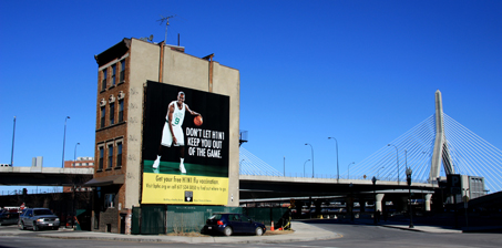
As I turn the last corner towards the museum, I see one of the most pitiful urban landscapes I have ever laid eyes on, and it takes me by surprise. One lone tenement house, the last of its kind, stripped from the row to which it belongs. Adding insult to injury, it bears the indignity of two enormous billboards plastered on its bare walls. Cars swoop by on their way to the Zakim Bridge, the tenement’s only company. Why is this poor tenement still here? Who lived here before? Did someone stand in front of the wrecking ball in a last ditch effort to save their home? Was it going to be repurposed in some way? Is it being actively used now or is it vacant, or even condemned? I think this might be my anomaly, to be further investigated on a warmer day.
JOURNAL 02/12/10
I’ve been having some second thoughts about my approach to the first assignment. I might have been a little too specific about the questions I posed, since I talked about mostly individual instances that I find intriguing rather than looking at the site as a whole. I think the problem is that with so much of the original neighborhood gone, I’ve been looking at the modern West End as scattered pieces/artifacts of the old West End that I managed to bind into a site. But if I change my focus to some broader patterns, I think my analysis of the site will become a lot more cohesive.
The development of the waterfront, for example, I didn’t discuss at all. Currently, it is completely isolated from the new West End by Route 28 and Route 3A. There’s only one pedestrian bridge to cross over with, and once you do, you’re met by a six or seven foot tall fence running the length of the park. How was this land used before the highways came through, and how is it used now? I’m sure the waterfront made this property desirable for urban renewal (besides the proximity to downtown).
Also, the entire area has been rebranded to attract the upper middle class. There are billboards all over the sides of these new apartment buildings for luxury apartment living, with the slogan “Live Boston’s West End.” The irony of that just kills me. But if there’s so many of these advertisements for apartments, are there a lot of vacancies? Who really lives here? The goal of most redevelopment projects was to bring back the spending power of the upper class from suburban living to the vicinity of downtown businesses, which is probably why the new West End is landscaped so similarly to the suburbs. But did that demographic actually come back? Either it was a slow process, requiring lots of propaganda, or maybe the area has taken a hit with the economy and those billboards have only been put up recently.
On a related note, the few people I’ve seen in the area were generally walking their dogs, and I’ve made it a point to try to meet them (since I love dogs, and that tends to be a great opening with people). None of them have been residents, but they cross the bridge from Charlestown or Cambridge for their walks. I can see the appeal, given the open landscape and the pedestrian-only streets. So in addition to who lives here, who visits here and why? Was this intentional or a side effect of the development?
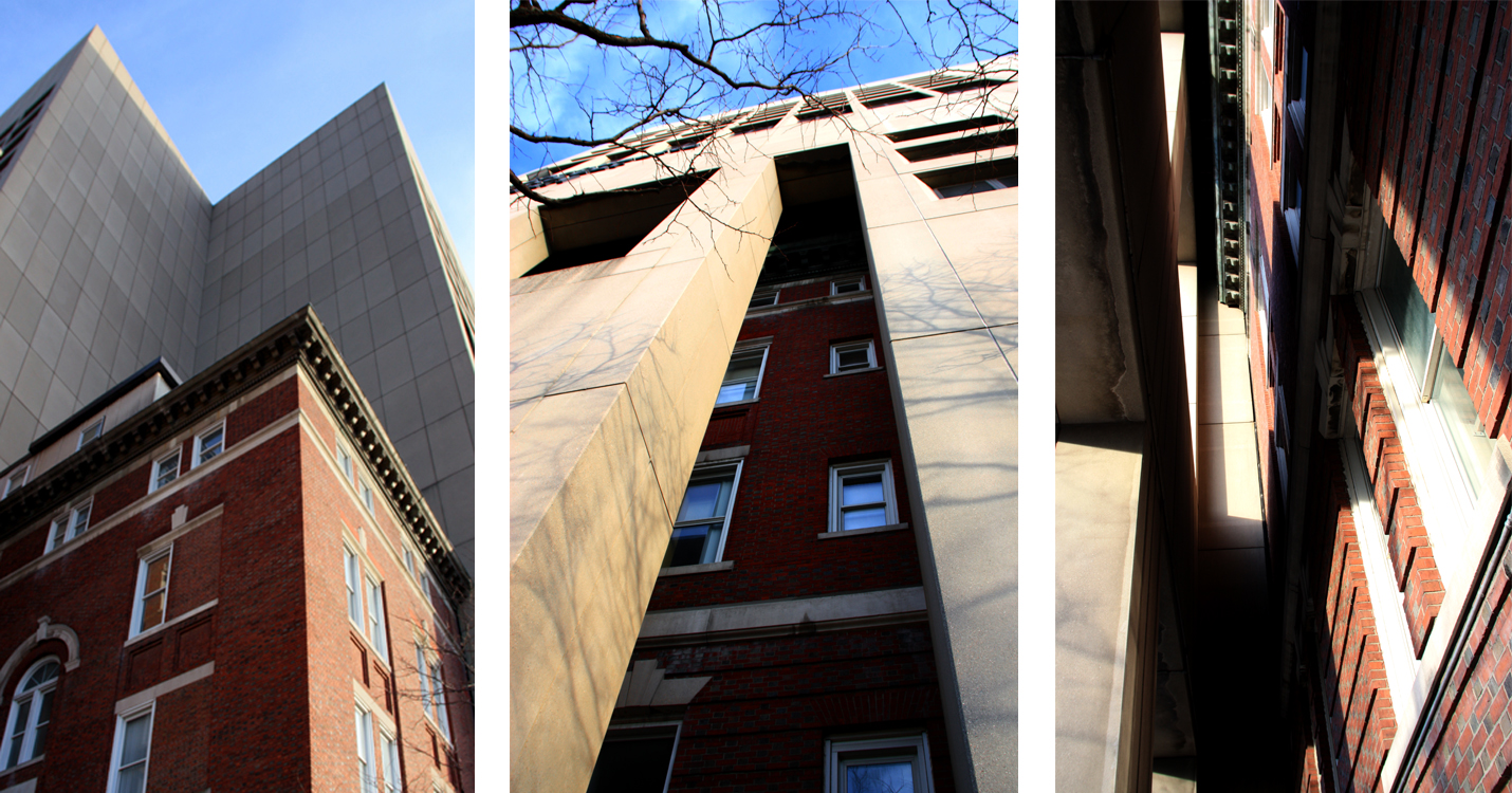
On an unrelated note, I have added a new favorite building on my last site visit. It’s a fairly ornate, brick building dated from 1827, and Mass Eye and Ear literally just absorbs it. From one side, the building stands apparently adjacent to Mass Eye and Ear, and the hospital’s footprint is the negative of the brownstone. But looking a little closer, the brick building then gets swallowed into the concrete façade and is hidden behind it. Maybe it was the Chief of Medicine’s mansion or something and it was just too beautiful to knock down when the hospital was updated. I attached some photos below. I love how you can see such a dramatic difference in scale between the old and the new, the idea that pieces of the West End can be hidden or embedded in plain sight.
JOURNAL 02/26/10
I’ve been thinking it might be a good idea to change the site I picked in the West End to basically its inverse. Instead of the superblock, I think it would be really interesting to look at the West End closer to Cambridge Street. I didn’t notice this until I started looking at the Sanborne maps, but it’s really interesting to look at the land surrounding the Charles Street Jail versus the land around MGH. Both are strong institutional presences, the original buildings and campuses are about the same scale, and they stand out compared to the rest of the neighborhood because of their massive size. Whereas MGH keeps encroaching and building on and nearby land, the jail maintains a strict boundary and remains a cruciform island (odd shape for a secular building…) on its land, with a periphery of small municipal buildings (the city morgue, stables, etc) to isolate it from the residential areas. I’m not sure when the jail actually closes, but eventually MGH sort of blasts through the few blocks separating them and builds right up to the back of the jail. Why were these institutions situated in the West End in the first place? I’m guessing that since their original sites are on the newer, filled land in the West End, they intentionally distanced themselves from the older residential areas near the shipyards on the peninsula.
And then what effect does this have on the commercial and residential areas along Cambridge Street? I think I would cross Cambridge Street just enough to get the street frontage on the Beacon Hill side, just for a baseline comparison. But as of 1890, it’s a very lively area with a mixed-use street front, including several hotels, as well as schools and churches. Today, I know that this area is now mostly associate medical facilities like Mass Eye and Ear (or parking lots for them). Did the commercial area begin to die off, which made the land an easy target for institutions to move in? The street grid is far more closely intact than the superblock, which probably suggests that the change was more incremental accumulation of lots than the upheaval that came with urban renewal. If so, there’s probably also a better cause and effect chain that would leave more of a trace in historical maps than the northern side of the West End, which basically goes from low-rise to high-rise residential in a blink.
And while that last tenement did elicit an emotional response from me when I first happened to find it, I think, being such a small-scaled exception, it doesn’t give rise to as much complexity as the growth patterns occurring on the other side of the West End. I’m most likely going to develop it as the subject for my term paper in one of my other classes this semester (Downtown with Professor Fogelson), so I’ll still end up delving into the story behind it. And I’m sure the research will add to my perspective on my new site, assuming I change. Also, the Otis House, the Winchell School, the West End House, an upper-class townhouse that I can’t identify yet, and the Old West Church are all original buildings on the Cambridge Street side. Because of their close proximity to each other, they create a remnant of the previous urban fabric, which might be more interesting to study just an isolated structure.
Maybe it will become clear which site has the advantage when I start looking more closely at this next assignment (looks like it will generally be peninsula versus infill). But I would appreciate some quick feedback, if you have a chance, before I head back to the West End this weekend.
JOURNAL 03/19/10
Spring break is coming up and there are a few long car rides in store for me where I can get a lot of class reading done, so I spent most of my time this week researching the West End instead. I downloaded some of the Bromley and Sanborn maps to play around with, and I also pulled the 3D CAD model of the West End off the BRA website so I can make some new drawings of what I find. Haven’t quite sat down to do the major analysis yet.
The most interesting thing that I found, though, is the original 1953 redevelopment study for the West End from the Boston Housing Authority (The BRA wasn’t founded until 1957). Their first pass at the project is way better than what actually was developed. They actual retain 357 residential buildings as well as many of the schools while adding a new elementary school. Also, they recommend supporting a large parcel of light industry on the North Station side of the site, which makes so much sense given that it has access to so many types of transportation between the Central Artery, the harbor, and the railroad lines. The rest of the plan seems similar, with high-density 13 storey buildings and a lot of suburban-like landscaping and plenty of parking. But 30% of it is supposed to be public housing, with the remaining 70% middle and upper income apartments. The size of the project was far less ambitious as well. It left all of the blocks along Cambridge Street fully intact, and the southern boundary was parallel with Mass General’s campus along Fruit Street instead. I wonder why the public housing, light industry and retained/rehabilitated housing were all dropped from the program. I bet it has something to do with the federal money they were able to get, and that it was contingent on close to strictly residential new development, instead of mixed use.
Even though this draft plan is surprising less invasive than what was eventually realized, their rationale for the need to redevelop the West End in the first place is still pretty scummy. They have all sorts of graphs and drawings to show where the substandard buildings are, which ends up being a full 80% of the plan, but they never state their criteria for what makes substandard housing. And to prove their point, they relate the population decline seen in the West End and the decreasing family size to mean that the quality of the housing is causing people to leave. But their logic is arguable at best, even their language is absolute. The population drops from 22,000 to about 12,000 overall but almost completely levels out in the three most recent decades prior to the study, and all sorts of phenomena go totally unmentioned that might account for the sudden drop from 1910 to 1930 like new rail lines, the proliferation of the car, the Great Depression, etc. I’m confident that those numbers would be falling similarly to the rest of Boston as people move to the suburbs. You can definitely tell that the Housing Authority went into this study with an outcome in mind, and then found only the data that proved their points.
I listened to a pod cast recently of a walking tour of the West End given by previous residents who were 18 or so at the time of the redevelopment. One of the men says that the entire area from the backside of Beacon Hill to the North End were essentially a uniform city fabric in terms of demographics, scale, age, building quality, etc. And he wonders how they could have possibly put a boundary on the West End as a slum when really that would make the entire area a slum as well. Fogelson calls this “inventing blight” and I think I’m going to be writing a paper about it for his class, especially given how fun it was to look through this redevelopment plan. I know from Urban Villagers that the North End and the South End were also slated for renewal in the General Plan of 1950, and the BRA ultimately decided on the West End to move forward with. I’m going to try to find more government documents from just before the West End’s redevelopment to see exactly what factors “sealed its fate” so to speak.
Other than that, this redevelopment plan came with a few extra diagrams and drawings that I’m sure will come in handy. One is this awesome topo map overlaid on the 1953 plan and you can see exactly where the old peninsula falls compared to the flat filled land I was talking about in my last paper. The harbor-side peak they flattened out a bit as a part of the new construction, but the Old West Church is still exactly on top of that second peak. Also, the figure ground they include is amazing in terms of how dense this neighborhood actually was. And lastly, the 1953 zoning map is interesting to take a look at. It looks like Chambers Street was sort of the main drag in terms of local retail, which makes sense now that I think about it since its one of the older streets. Leverett Street still was running light industry even in 1953. In 1775 that’s where the shipyards were located. I guess that makes a lot of sense that a commercial district along Chambers Street would run parallel to Leverett, back behind its industry, and a buffer and interface for the residential district that fills in on the other side of Chambers St.
JOURNAL 04/16/10
I’m a little bit concerned about this assignment, given that my site is so polarized into basically just two time periods. All of the surviving pre-renewal buildings are on the map as of 1900, with the exception of the MGH additions. And generally, they stay because they’re either considered a landmark, or in the case of the Otis House an actual museum. That or MGH has the property rights in order to pre-empt other new construction where they might like to expand one day.
In addition, the post-renewal buildings were all built at the same time, so that doesn’t offer much diversity in terms of layers either. I definitely haven’t focused much of my attention on them, though, thus far (maybe as some sort of mental protest to their existence) so given how much of this assignment is based on future trends, I should probably get around to taking a look at them more closely.
On the other hand, maybe this paper will go really well because I’ll have to rely on smaller details as clues for analysis. I love the example that Jane Jacobs uses with the bookstore sign in Brooklyn as a far more sensitive indicator of downtown activity than any calculable statistic (442). I hadn’t even thought of looking at signage, but she’s completely right. I’m realizing that I walk by the Holiday Inn almost every site visit that I make, and it’s actually called “Holiday Inn Boston at Beacon Hill.” There’s no way that Beacon Hill has any room for a hotel of that size, but they still need the service so it pops up on adjacent land in the West End instead. And that’s just the sign that I’ve noticed. I’m sure there are several other ones that I haven’t done more than glance at.
Also, I’ve never been on the site at night before, and I’ve really yet to see any pedestrian activity besides on Cambridge Street, Staniford Street, and the MGH entrance. So the plan for today is to go take some photographs and hopefully salvage a bit of light on this overcast day, head indoors to the West End Library to get some of my thoughts down, and then go to dinner on Cambridge Street somewhere with a window seat. I’m curious whether the more residential parts become more active at night once people are home from work and maybe going to dinner in the area themselves.