
Site Selection
February 16, 2010
In 1958, over 7,000 people were displaced from their homes in the West End to make way for the city’s redevelopment of the valuable downtown, waterfront real estate. While Boston authorities painted the area as a dirty, hazardous slum to advance the redevelopment cause, The West End in reality was a working class neighborhood of 2,300 first generation families and a close-knit, culturally vibrant community. The fact that 1,500 individuals still subscribe to The West Ender, an independently produced newspaper that keeps former residents in contact, some 50 years after the neighborhood was destroyed is a testament to how connected the West End was as a community. I was drawn to the old West End for this class precisely because of this intense connection that West Enders hold for their ghost neighborhood, which is shown in the image below. It gives the project a layer of anthropologic and archeological exploration because the remnants of the West End that did survive the redevelopment must be particularly telling of the community that rallied to save them.
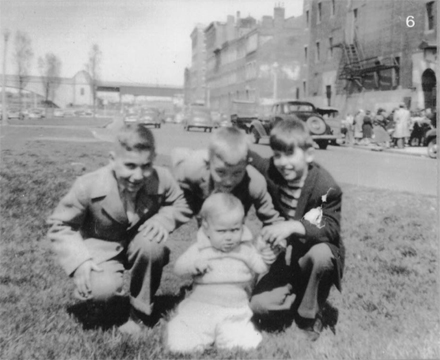
[Image courtesy of the West End Museum]
There are three specific anomalies that I’m most interested in uncovering. The first is a building that has become known as “The Last Tenement.” Not only is it the only tenement that survived the urban renewal process, it also appears to be one of the only original West End structures that has not been repurposed. Its four floors and basement level are likely still arranged in the original tenement layout, since a closer look at the ground floor buzzer shows that five occupants still live there. Their names, listed as “Mitchel, Reardon, Majid Bensellam, Kazonis, Procopio,” show that the tenement might even continue to house first generation immigrants, from the Greek and Italian populations that were once very predominant in the West End to one of the newest waves of immigration from Southeast Asia. Of the 30 blocks of housing in the West End, why was this the only tenement spared? Why this particular building out of its row? Was it the effort of its residents? A political compromise? Given the major roadways that intersect around its small lot, was this building simply lucky enough to fit within the turning radius of a car?
A second anomaly occurs in the center of the megablock that contains most of the new development, which is generally luxury apartment towers. Several parking structures occupy the periphery of the block allowing the majority of the internal streets to be pedestrian paths. Any street designed for cars penetrates only as far as the width of a parking lot, and terminates in a cul-de-sac with a landscaped building entry. Blossom Court’s cul-de-sac, however, ends with a older building’s service entrance along with signage pointing visitors to “J. Pace & Son Front Entrance” on the building’s opposite side. After following a small footpath circling the building, I found J. Pace, one of a string of ground floor retail shops along a wide, unlevel pedestrian passage. The shops face an entrance to the Boston Synagogue, which was built to serve the Jewish population of the West End as a counterpart to the Old West Church. This area could easily be a remnant of the old street grid, given the proximity to a landmark, the condition of the path, the backwards orientation of the shops, and the abnormality of pedestrian-only retail. Were these shops first placed to attract customers after services? Who were the original retailers? Was this a Jewish neighborhood? Are any other blocks intact?
The third anomaly is an overall pattern rather than a specific location. I noticed at least three different varieties of streetlights along the roads of the West End. Interesting patterns began to emerge which may be helpful in determining which streets are original to the West End. In cases like Blossom Street, ornamental streetlights line the north-south and east-west straight-aways and the most modern looking lights are positioned around its bend. This might suggest that Blossom Street is actually composed of two former West End streets connected by a newer bend in the road to eliminate their intersection in favor of a continuous street, which neatly binds the entire Mass General Campus into one large block.
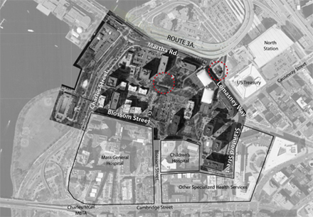
[base map from Google Earth]
The above image is my site map, which incorporates all the areas and anomalies of the West End that I would like to study further. The Mass General campus and its associate medical centers, the elevated infrastructure of route 3A, and the Charles River waterfront bound the site. Red circles indicate incidents of anomaly.