
The West End’s Story
From Farmland to Subway Suburb
Today’s West End is an extremely polarized environment, and the conflicting forces have been building for over a century of development on the site. The neighborhood’s beginnings as a “stable, low rent” residential area were eroded away over time by adjacent healthcare institutions and the social agendas of nearby Beacon Hill (Jacobs, 272). These layers of development would compete until urban renewal swept away the vast majority of the low rent residential areas in the early 1960s, leaving the healthcare institutions and upper-class development free to expand.
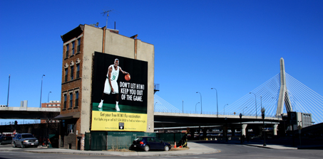
Image 1 – This four-story walk up is one of the few surviving buildings from the pre-renewal layer, devoid from its previous residential block. The land it occupied was considered better used for other purposes, then razed and redeveloped by the city.
The surviving buildings are now artifacts of the original neighborhood, and the traces they contain tell the story of site’s past and indications for its future. This story of the West End is captured by a six-block study site that embodies all of the key characteristics of the area, including reclaimed land from the Charles River, the Massachusetts General Hospital campus, the pre-renewal residential character, and the major thoroughfare of Cambridge Street. Refer to the following map for the site’s boundaries and important features.
Site is bounded approximately by Cambridge Street, Charles Street, Staniford Street, and Blossom Street. This map is also a legend for the location of each photograph.
Early History
The West End was once a small landmass extending from the base of the Tri-Mountain peaks in Beacon Hill until its gentle slope reached the shore of the Charles River. The earliest structures were almost exclusively residential and built on the higher contours of land, with the flat, coastal areas reserved for farmland. As the city’s population grew, Boston implemented an ambitious plan for land reclamation from the Charles River. The West End’s farmland was built up from the marshes along the coastline to become docks, and through continued land filling efforts, the site eventually doubled in size from the 1800s to the 1950s.
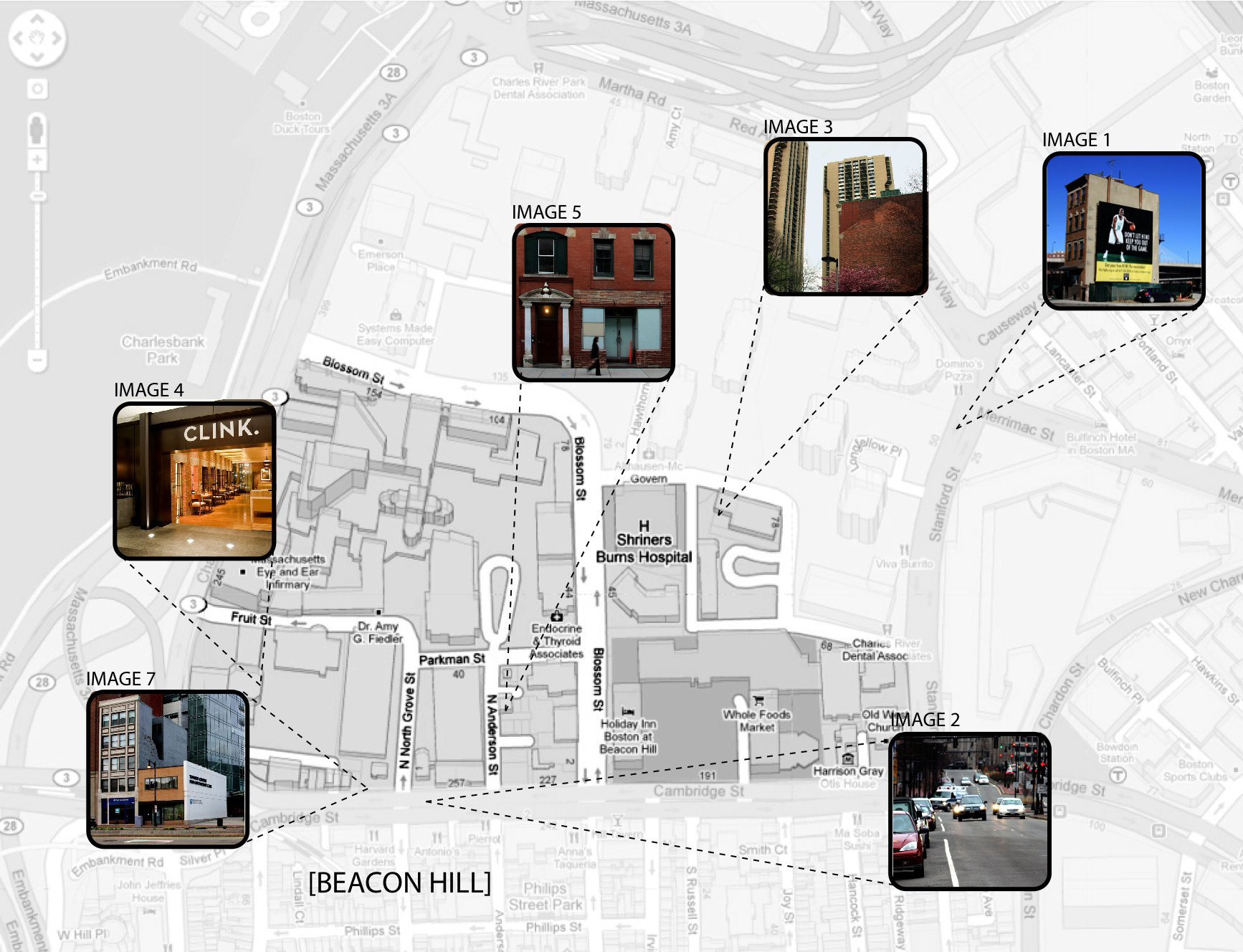
The manmade land reclaimed from the harbor was built to be flat and therefore inexpensive to construct and construct upon. While this construction plan made sense economically, it dismissed the natural topographical logic that influenced the original settlement pattern on the site, which placed the housing on the high land, safe from the ocean and the elements, and only farmland on the coastal floodplain. Consequences of this decision can still be seen today. The new land interrupts the water’s path to the river because of it was filled to be as level as possible. As a result, the new land collects considerably more standing water than the original, sloped land, the effects of which are recorded in the low-lying areas of the site where excessive water damage has cracked the pavement and building foundations. One of the only other indications of the original West End topography is the discernable slope of Cambridge Street as it descends from Government Center to the waterfront, shown below.
Though seemingly inconsequential to the site’s modern development, the original topography of the West End played a large role in its early development, both in its physical built form and its socioeconomic foundation. Herbert Gans describes the settlement of this time period in his book, The Urban Villagers, as a meeting ground between the “Back of the Hill,” where the servants to the aristocracy of Beacon Hill lived, and the lower-middle class families who had worked their way up from “the bottom of the slope,” meaning the dense, low-income waterfront areas (Gans, 5). Because large estates were difficult to establish on the backside of Beacon Hill, due to its steep slope, a socioeconomic gradient was physically manifested from the rich hilltop residents to the poor, immigrant communities on the shoreline.
The Cambridge Street portion of the West End was centered around the middle of this gradient, and it generally attracted working-class residents with work opportunities within the local lumber-based economy. Skilled laborers and tradesmen found work as carpenters and furniture makers, while unskilled laborers had job opportunities at the docks, lumber yard, or organ factories present on the site. Simultaneously, the upper class of Beacon Hill made the jump across Cambridge Street in the form of specific buildings, like the Harrison Gray Otis House in 1795 and an elaborate renovation the Old West Church in stone in 1806. Both buildings were sited on the highest point of the landscape, which traditionally symbolized affluence.
Conflicted Development
However, the relative balance between the upper and working class residents within the site would be short-lived. The lumberyard relocated inland from the wharf after the Charles River Embankment is filled in along the lumberyard’s old site on the river. It went out of business entirely by 1938, and with it the entire local economy. No new manufacturing industry took its place because while the former factories were in a prime location for transportation, including the steam railroad hub further north of the site which would eventually become North Station, trucking was now the preferred method of shipping for industrial America. This allowed for industries to move to cheaper suburban land with more space to expand while maintaining their access to the markets. Instead, Mass General Hospital, established on the site in 1818, bought up the abandoned industrial land to expand its medical facilities, which replaced former laborer positions with primarily an educated workforce. As waves of new immigrants moved into the West End as an “overspill” from the crowded housing in the nearby North End, fewer and fewer of them were qualified for work opportunities in the area (Gans, 6).
The number of single-family homes plummeted during this time period. At the turn of the century, about one-fifth of the housing on the site was considered multi-family, and in many cases it was new tenement construction concentrated on the inner-block alleyways. Within 50 years, only 27 single-family units remained, all of which were clustered on the oldest blocks laid out in 1776 in conjunction with Beacon Hill. Once associated with the prestige of the Otis House and the Old West Church, the families living on these two blocks likely remained slightly more affluent than the average residents and most resistant to the multi-family reuse of buildings sweeping through the rest of the West End. Those who could afford to move evacuated the West End, which by this time was labeled a slum, to the suburbs, a predominant trend in most cities at this time. This flight for the suburbs is embedded in the historical maps of the site. The Sanborn maps document that many social institutions, like the Salvation Army and settlement houses, opened to offer services to the low-income neighborhood, while former buildings like the Old West Church no longer served enough affluent patrons to remain a Congregationalist Church. It is converted to a branch of the Boston Public Library by 1938 before reopening in 1964 as a Methodist church for the new, working-class West End population.
Change and Upheaval
It is right around this time period that the West End is first slated for urban renewal. Given the trends observed on the site since as early as the mid-nineteenth century, it is understandable why, on paper, the West End was viewed by the city’s politicians as a slum in need of clearance though drastic urban renewal. A hugely successful institution, Mass General Hospital, dominated the site with constant growth while the surrounding industries failed. Mass General had solidified is position as an asset not only as a resource for the public health, but also as an economic driver for the city. It’s in the city’s best interest to encourage its progress. Conversely, lower-middle class, single-family farmland had dissolved into a tenement neighborhood of some of Boston’s poorest residents who were heavily reliant on public services. The flight of industry to the suburbs disrupted the local economy, creating fewer jobs for skilled laborers and an overall decrease in income levels. The cheap rents available only attracted even poorer residents to the area.
By 1961, almost the entirety of the West End was demolished and reconstructed by the Boston Redevelopment Authority under the Federal Housing Act of 1949. In order to attract the upper-middle class back to the inner city business districts from their suburban homes, the BRA resolved to develop the area as a subway suburb called Charles River Park, with all the convenience of urban life within a typical of a suburban environment. Tall residential towers took the place of apartment rows, underground parking became available for every resident, and generous amounts of outdoor recreation space served as communal front lawns.
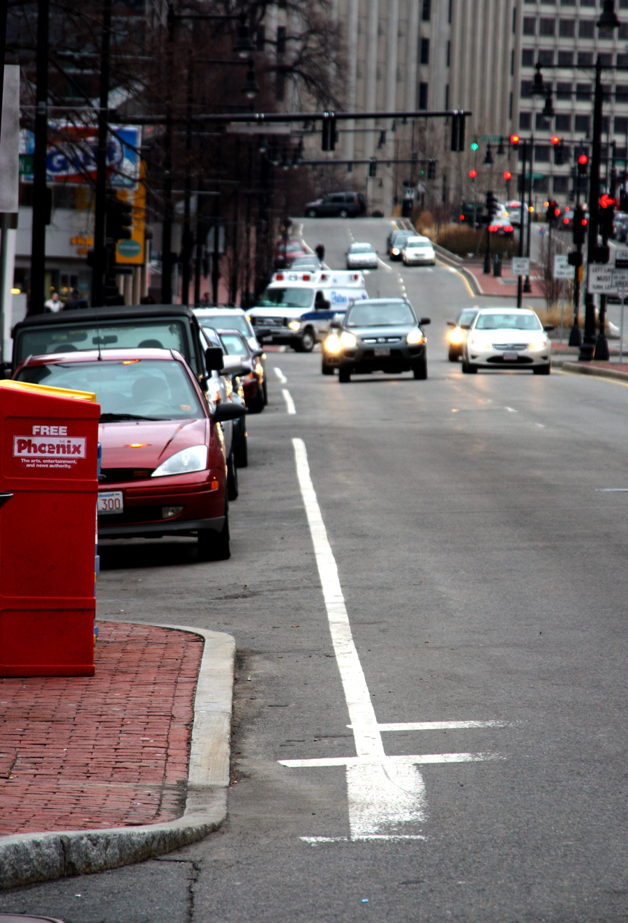
Image 3 – Preserved on the now exposed façade of St. Joseph’s Church, the scale of the previous low rent, walk-up style residences is enormously outweighed by the massive housing towers of Charles River Park.
Because all of this development was all constructed around the same time, the area has been relatively unchanged since its implementation in 1962. The Old West Church, the Otis House, the Charles Street Jail and St. Joseph’s Church were among the few buildings that survived the redevelopment through to today, except of course the Mass General campus and the few buildings it incorporated before the demolition.
Resolution
The dozen or so of these archaic structures make up the pre-renewal layer that was nearly eradicated entirely from the site in the early 1960s. The general attitude planning-wise towards these older buildings falls into the following two categories: celebrated artifacts or placeholders. Celebrated artifacts are the few fashionable buildings of the former neighborhood that ideologically were worth saving as status symbols for the elite, new Charles River Park. Often these structures are dutifully demarcated with plaques, which declare their historical importance. Placeholder artifacts, on the other hand, are never given such distinction. They have usually been bought by one of the many medical institutions, which use the presence of these old buildings to ward away new investors from building on land they are eyeing for expansion. In either case, both types of artifacts transition smoothly into the site’s homogenous post-renewal layer, full of tall, modernized healthcare institutions and luxury housing towers. These artifacts are either assimilated as symbols of the forced gentrification of the area or are slated for removal to allow the gentrification process to continue.
A key example of a celebrated artifact is the Charles Street Jail. Noted architect Charles Bulfinch, whose body of work contained many of the most illustrious buildings in Boston, designed the jail in 1843. It actively detained Boston’s criminals until it was shut down in the 1990s. Mass General bought up the property, and the condemned jail stood inoperable on the land for fifteen years until it was leased and redesigned as the posh Liberty Hotel.
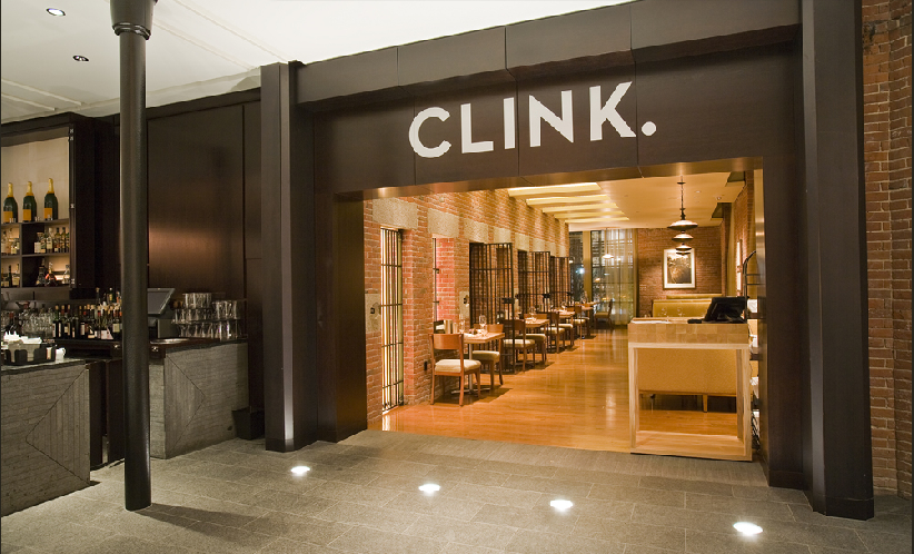
Not only was the original structure rehabilitated, the history of the jail was also rejuvenated as a unique selling point for the refined, luxury hotel despite the obvious clash with its harsh past. In fact, the 12 out of 300 rooms that were rebuilt within the walls of original cells are ironically the most expensive rooms in the entire hotel, boasting “floor to ceiling windows . . . which peer out through ornate ironwork” as advertised by the hotel website. Its history is certainly unforgettable while sitting in the hotel lobby’s two bars, named Clink and Alibi, pictured above.
The converse is true for 48 North Anderson Street, a row house, which though owned by Mass General now, is completely dismissed by passersby. The photos below capture exactly how little interest MGH has in maintaining this building.
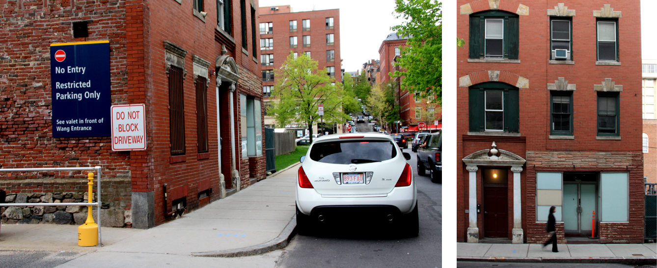
Image 5 - Notice the detailed entryway and window cornices as well as the ripped out ground floor in favor of a storefront from the building’s former uses. The signage on its side identifies it as a MGH structure with the hospital’s colors.
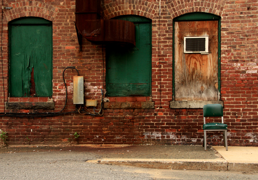
It has been clumsily retrofitted with what looks like an air conditioner protruding right through a boarded up window for the office workers, though their access to natural light is clearly not a priority. The entire block it sits on is used primarily as a parking lot, so the former streets were paved over with no concern for the existing sidewalk. It has been paved into the ground for the sake of additional parking spaces. Like many other placeholder buildings on the site, it will be demolished within the next few years for new construction by the surrounding hospitals.
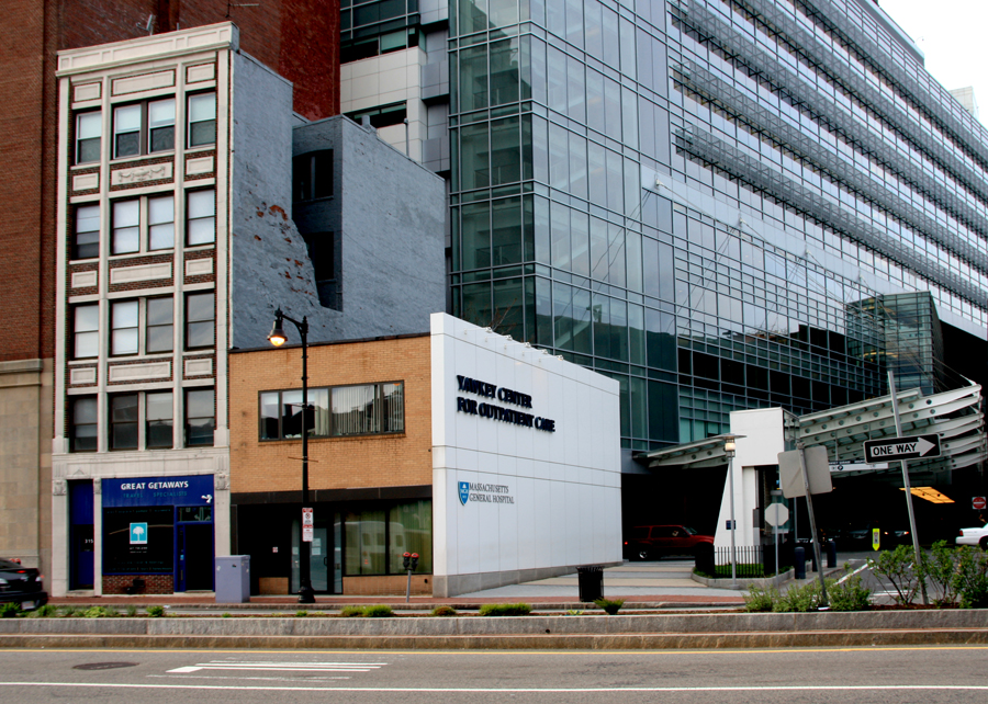
Image 7 - Clearly considered an eyesore compared to the new construction, Mass General constructed a wall to cap off remnants of old row houses along Cambridge Street to keep these placeholder buildings from appearing obsolete to patients entering its parking garage. The neighboring buildings were demolished recently to make room for the garage’s driveway.
Epilogue
The destruction of the old West End is generally viewed as one of the worst mistakes in the history of urban renewal. The homogenous, idealized development that took its place lacks the dynamism and complexity of the original settlement, and many people began to criticize the project within a few years of its completion in 1962 including renowned author Jane Jacobs in her book, The Death and Life of Great American Cities. She writes, "Cities happen to be problems in organized complexity . . . in which a half- dozen or even several dozen quantities are all varying simultaneously and in subtly interconnected ways. . . . The messes we create [with urban renewal] become despised by their own inhabitants tomorrow. These thin dispersions lack any reasonable degree of innate vitality . . . [and] few of them . . . hold their attraction much longer than a generation" (433 – 445).
Jane Jacob’s insightful prediction, made 50 years ago regarding the future of developments like Charles River Park, has certainly materialized on the site in recent years. In an effort to foster more of a community, the new residents are beginning to embrace the image of the old West End as a legacy that brings them together. Instead of referring to the area as Charles River Park, many signs refer to residents as West Enders. In addition, there has been a movement to rename the green line MBTA stop “Science Park/West End” to revive interest in the neighborhood’s history. A vibrant, if low-income, community is a trademark of the old West End. Although it no longer exists in physical urban form, the West End’s culture and legacy are beginning to take root on the site once again.
Works Cited:
Gans, Herbert J., The Urban Villagers: Group and Class in the Life of Italian-Americans. New York: Free Press, 1962.
Jacobs, Jane. The Death and Life of Great American Cities. New York: Vintage Books, 1961.