Massachusetts Institute of Technology –
Department of Civil and Environmental Engineering
Prof. H.H. Einstein, Prof. S. Slaughter
1.012 – Introduction to Civil Engineering Design
Scope
and Background
The
industriplex Project is the third design project in 1.012.
It is, similarly to the Charles River Project, a large scale
planning project. However, there are some important differences:
-
Rather than hypothetical development in a real setting as was the
Charles River Project, this is real development in a real
setting.
-
You will go through two stages and end up selecting an
alternative.
-
The project will be revisited in some of the
follow-up design projects. In particular, you will do detailed
planning and design in the capping subject 1.013.
Design
Exercise
Industriplex
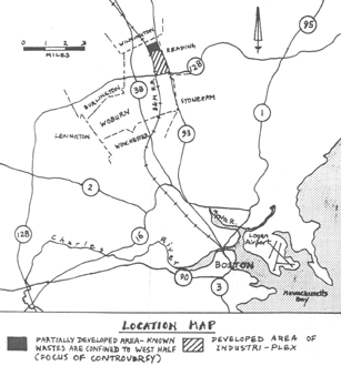
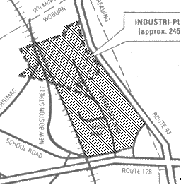
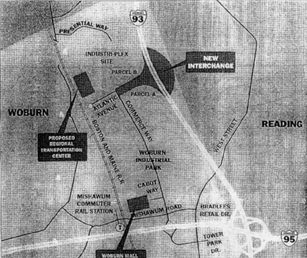
is a 244 acres ( 987,430 m2) site located near the intersection
of Interstates I-93 and I-95 (Route 128) in Woburn, MA (Figures 1
and 2a). Woburn is a city of 35000 inhabitants in the
middle and lower middle income range with significant industrial
and commercial facilities. The Aberjona river, which runs
North to South through Woburn and eventually flows into the
Mystic Lakes also runs through Industriplex site.
Figure
1:
Figure
2a:

Figure
2b:
The
Industriplex site and the Wells G + H site located just south of
Rt. 128 (Figure 1 or 2a) are federal Superfund sites. Woburn drew
national attention in the late 1970s when Wells G + H, two of the
city wells, were discovered to be contaminated and in the 1980s
with the subsequent court cases. In the Fall of 1995 there was
the book called, “A Civil Action” on which last
years movie was based, detailing the landmark trial involving
numerous Woburn families who filed suit against several firms
claiming the incidence of childhood leukemia was much higher
locally because of the contaminated wells.
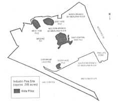
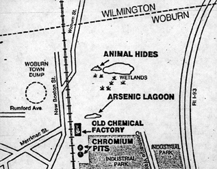
Figure
3: Hide Pile locations:
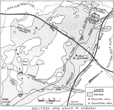
Figure
4: Topographic Map

These wells were closed in 1979. The Industriplex site was
the location of leather and chemical industry for a century from
the 1850’s till 1963., Contamination ranged from
discharges of arsenic and chromium, and volatile organic
compounds to the burying of large amounts of animal hides. However,
due to joint efforts of the EPA, the Massachusetts Department for
Environmental Protection and the Industriplex Residential Trust,
which represents the property owners, the contaminated parts of
the site have been concentrated in four places. They are
covered and are monitored (Figure 3). The site is ready for
development which has already started and as such will serve as a
national and possibly worldwide example.
The
Industriplex site provides the context for the 1-C Theme Project.
You will do some initial design work in subject 1.012. Subjects
1.031, 1.041 and 1.051 will have small design exercises
addressing some aspects of the Industriplex site. Finally
in 1.013, you will develop a or several major projects on the
site.
In
1.012 your task is to develop an initial Master Plan for the
region including the Industri-plex site and the contiguous
streets (shaded in Figure 2b). The constraints are: the
site boundaries, the waste storage sites, wetlands and levels
(figure 4). Details on the history of the site and on the
constraints are given in the attached background material. You
will note that wetlands can be replaced in kind on site and that
contaminants may still flow from the waste sites into the
underlying terrain and the groundwater and also into the Aberjona
river. Land use in certain areas (specifically those regions with
hide piles) is, therefore, limited to commercial, office, retail,
etc, but residential buildings are not allowed. Clearly, land use
could be extended if higher levels of contamination control
and/or active remediation can be applied. Present plans
foresee hotels, stores and offices but you should seriously
consider other options. Also, the location of the
intersection of two major highways makes the site very well
suited as a transportation node. Right now there is a
parking facility with a direct bus to Logan airport; the official
plan includes a major transportation facility incorporating this
Logan transport link, and a train and subway station. Again,
other options are possible and you may look at the entire Boston
area transportation network in this regard.
At
this point in your civil engineering education, you do not have
the knowledge to develop a sophisticated Master Plan. What
you can and should do is to consider as many options as possible
regarding what to do with the site to produce optimum benefits
for people using it, the developers, the city of Woburn and the
Boston Metropolitan area. Considerations should be
technical, environmental (natural and social), economic and
aesthetic. You may also think of “making a
statement” given that this site can serve as an example of a
redeveloped Superfund site.
In 1.012, you will do the project in two phases. In the first phase, you will develop an initial Master Plan. This has to include the proposed use of the site and the reasoning leading you to this. You should devise a rough street and zoning map possibly going into further details as to what you would like to have in the different zones. Your arguments leading to your decision need to accompany the plan. If you need further information in addition to the one provided to you, you need to let us know. As in the other projects in subject 1.012, you should use the discussion site on the class web page (http://command.mit.edu/1.012).
The
result of the first phase will be critiqued by the faculty and TA
teaching the subject.
In
the second phase, you will use the critique as well as additional
information on the actual development which we are going to give
you. On this basis, you will refine your Master Plan.
This information should not necessarily lead you to an adaptation
of the actual development. Also, and this is the most important
part of the second phase, you have to identify the critical
and/or unresolved problems.
In
the presentation at the end of 1.012, you will describe your
refined plan and the critical/unresolved problem.
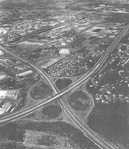
Figure
5: Aerial View of the Route 128 and I 93 Interchange,
Industri-Plex and environs.
Industry fills the area to the left of I-93 and above Route 128
(I-95). The area below Route 128 belongs to another industrial
park. The residential west end of Reading, Massachusetts is to
the right of I-93. The chromium lagoons and arsenic pits were
located mostly in the upper third of the site, as well as the
hide piles (relocated after excavations when buildings were
constructed).
1.
Context
Woburn,
Massachusetts is located approximately 10 miles north of Boston
(figure 6).
Figure
6 Location Map:

Figure
7 Wells G + H:
The
city has two federal Superfund sites, the Industriplex, Wells G
& H (figure 7), and forty state Superfund sites. In 1979 the
Massachusetts Department of Environmental Protection (DEP) closed
the two municipal water supply wells because the water contained
high levels of volatile organic contamination. During the same
year the Environmental Protection Agency identified the
Industriplex hazardous waste site as one of the largest hazardous
waste sites in the country. It was ranked number 5 on the
National Priorities List of Superfund sites.
The
Industri-Plex site is a classic example of the estimated 10,000
plus sites around the country known to contain hazardous wastes,
which are suspected of polluting the air and jeopardizing
drinking water. Of these, the EPA estimates that about 2,000 pose
“significant problems” for public health and has named
418 of the worst sites as eligible for Superfund money.
Industriplex can serve as a case study to focus on a national
environmental problem of how these sites are developed and how
they are being handled today.
2.
Background
The
Industriplex property contains two branches of the Aberjona River
(figure 8), streams, ponds and several wetland areas. Residences
are located within 1000 feet, and more than 34,000 people live
within 3 miles of the site. It was the site of the former
Merrimac Chemical Company, one of the largest chemicals
manufacturers in New England. For over 100 years the property was
used for chemical manufacturing and glue making. Waste material
was disposed of on the property, as was the common practice at
the time. There were 55 acres contaminated with high levels of
chemicals from the manufacture of arsenic based pesticides,
sulfuric acid, chromium and lead. Approximately 20 acres contain
buried animal hides used in past manufacturing processes.
Groundwater was contaminated with benzine, toluene, and dissolved
metals from reduced oxygen conditions created by the hide wastes.
Figure
8: Aberjona River Watershed

Figure
9: Chemical Disposal
3.
Site Setting
During
the 1970s the site included some occupied office buildings and
industries, railroad tracks, power line right-of-ways, and old
abandoned manufacturing facilities. Adjacent to the site is
Woburn’s sanitary landfill (figure 9).
During
this time, the property was purchased for the development of a
shopping mall and industrial park. Excavation uncovered the
buried animal wastes, creating a hydrogen sulfide gas odor that
invaded residential areas and mobilized the public. Efforts
to stop development took years. The developer had permission from
the Massachusetts Department of Public Health, the agency
responsible for hazardous waste at the time, to excavate and
consolidate waste material on the property. In doing so four
piles of hide wastes, commingled with soils containing arsenic,
chromium and lead were built. Figure 9 shows the approximate
location of a 35,000-square-foot lagoon containing 6,500
cubic yards of toxic chemicals, chief among them arsenic and
lead. Nearby, three pits containing high levels of lead and
chromium were discovered. Area residents, familiar with waste
deposits on the property, took their complaints to the local
government agencies, the DEP, EPA and Army Corps of Engineers who
filed an injunction against further development of the property.
4.
Pre-remedial conditions
The
following summarizes the findings that form the basis for the
selection of the remedial actions:
1.
The groundwater flow is north to south in a buried valley
running under the Aberjona River.
2.
The groundwater flow rate in the buried valley is about 0.2-1
foot per day.
3.
Levels of arsenic (100 – 420 ppb) and lead (120 ppb)
above drinking water standards (50 ppb) were detected
sporadically.
4.
Zinc was found onsite and downgradient wells above the
secondary drinking water standards (5000 ppm).
5.
Localized high ppm levels (32 ppm) of benzene and toluene
were found onsite. At wells immediately downgradient of the site
boundary, 747 ppb benzene and 177 ppb toluene were found, but no
benzene or toluene was found at wells further downgradient.
6.
No potable water supply wells are operating downgradient of
the site within about 1-mile. However, the groundwater from the
site flows towards Woburn municipal drinking water wells (G &
H) currently not operating (Figure 7).
7.
Generally, heavy metals were below drinking water standards
even though higher levels were found occasionally and organics
were higher upstream than downstream.
5.
Containment Activities
The
site was “remediated” (in fact it was only contained)
by the Industri-Plex Remedial Trust, comprised by 22 current and
former owners of the land, under the direction of the EPA. The
groundwater has been studied over the past years, although the
groundwater remedy design is not yet final. However, the soil,
wetlands and odor remedies have been implemented. The actions
taken are to contain the toxic material within a defined area and
to reduce their spread to contiguous areas and the water table.
The wastes have not been removed or neutralized. The EPA-approved
final remedy as outlined in the 1986 Record of Decision include:
Figure
10: Section of the caps
Figure
11:
1.
The design and construction of permeable caps to cover nearly 110
acres of soils and sediments contaminated with lead , arsenic and
chromium above federal action levels shown in Figure 10;
2.
The design and construction of an impermeable cap over
approximately 5 acres of the East Hide Pile, the remaining active
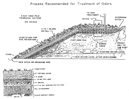
odor source, and a gas collection and treatment system to capture
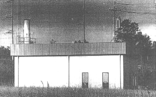
the release of hydrogen sulfide gas shown in Figure 14.
3.
The design and implementation of Institutional Controls.
Institutional Controls are required by the Consent Decree to
maintain the integrity of the remedy while permitting the
greatest possible use of the site (figure 15).
4.
Soil containing high concentrations of heavy metals had be
covered with clean soil. Permanently covering the contaminants
will prevent future physical contact and coverage was only
applied to those areas already contaminated (figure 11).
A
few more details on these remedies are given below:
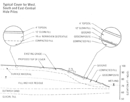
1.
After clearing the area, the four hide piles (South Hide Pile,
West hide Pile, East-Central Hide Pile and the East Hide Pile,
shown in figure 12 which comprised roughly 40% of the surface
area were covered. The materials used to cover the South, West
and East-Central hide piles were a layer of compacted fill, a
layer of nonwoven geotextile membrane that will prevent washout
of soil, 14 inches of clean fill and 4 inches of topsoil (figure
10). This permeable soil cap will enable liquids and gases to
flow through. The permeable cap is complete but awaiting final
EPA inspection.
Figure
12: Location of hide piles

2.
In addition to the aforementioned layers, the East hide pile was
covered with an impermeable cap of soil over a drainage layer, a
layer of impermeable synthetic membrane instead of the permeable
membrane and a 12-inch layer of gravel to absorb the gases that
caused the odor. Unlike the permeable layer, this cap will
provide a barrier, restricting the flow-through of liquids and
gases. A gas collection system was built under the impermeable
layer to collect and treat hydrogen sulfide gas and other gases
produced by the decomposition of organic hide wastes (source of
odors). Currently, the impermeable cap and the gas collection and
treatment system are complete (figure 14).
Figure
13: Groundwater treatment system

Figure
14: Gas collection and treatment system
3.
The design of the interim groundwater treatment system (figure
13) was initially completed in 1992, however the system was
altered to reflect changes from a pilot air sparging design in
1993. The air sparging system was operational for a short time in
1994 until it was discovered that the system failed to meet
design standards. The system is currently undergoing alterations
for an oxygen injection design and may be operational in 1998.
Figure
15: Institutional Controls

4.
A draft Institutional Controls document was prepared by the
potentially responsible parties in 1996 and is expected to be
finalized by the EPA/DEP by year-end 1997. The draft
Institutional Controls document divides the property within the
site into four categories or “classes” of land shown in
figure 15, in order to establish a clear method of regulating
land use and minimizing the risks of exposure. The most stringent
controls exist for Class D land (the hide piles) with
progressively less stringent controls on Class C, Class B, and
Class A. Class A land has been found to comply with the S-1
category of soil under the Massachusetts Contingency Plan, and
has unlimited uses, except for a prohibition on groundwater use
until such time as the EPA/DEP determine otherwise.
6.
Development Activities
Twenty
years after it was placed on the federal Superfund priority list
as the fifth most polluted hazardous waste site in the country,
the property will finally be at hand as a development known as
MetroNorth Development. The site is viewed as a success and
possibly a national model for similar jobs. It is believed an
example in two ways: it is the only Superfund site that has been
rehabilitated for public use as well as being the only case where
the remedy contemplates not only cleaning the site but returning
it to productive use.
Although
22 previous and current property owners were identified as
“potentially responsible parties,” most of the cost of
the cleanup was born by Monsanto Company and Stauffer Management
Company. These two chemical companies which were found to have
contributed to the pollution, are hoping to be partially
reimbursed with revenues from future land sales. Those sales will
also compensate Woburn for back taxes and state and federal
environmental agencies for their expenditures on the site.
More
typically toxic sites are cleaned up, fenced and abandoned. In
this case, portions of the site that were home to chemical
manufacturers will be reclaimed for commercial and industrial
use. In addition, a Regional Transportation Center will link
Woburn to Boston and to Logan International Airport. A new
interchange with Interstate 93, a mile to the north of Route 128,
is also under construction. Environmental planners and regulators
say cleaning up hazardous sites and putting them back to
productive use will start to become more common.
However,
there are still problems though, that prevent this system to
become widespread. Questions about new owners inheriting legal
liabilities for subsequently discovered pollution, uncertainty
about appropriate clean-up technology and fluctuations in real
estate prices. For the Industriplex case, future owners cannot be
held liable for past activities and contaminants on the site.
The
benefits from this approach are threefold. For the taxpayer, it
means a private company will shoulder at least part of the
cleanup cost. For the developer, it offers a chance to reuse
otherwise unusable land in often choice locations with services
and highway access not available at other sites. For society at
large it means steering industry to urban locations where jobs
are most needed while limiting the urban sprawl.
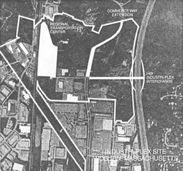
At
this point, the redevelopment is comprised of several mayor
projects: the interchange off I-93, the Regional
Transportation Center and private development on two parcels
known as parcels A and B (figure 16a). On parcel B the developers
will build an office park and hotel while on parcel A a retail
center is foreseen. The public projects have already been
discussed in the first design project and additional information
is given here. The private development projects are introduced
below.
Figure
16a: Redevelopment projects

Figure
16b: New exit off I-93
In
order to implement the cleanup, the EPA designated a custodial
trust in the consent decree to overlook the remediation process.
As part of the settlement, in exchange for giving the land to the
Custodial Trust, the previous owner did not have to pay for the
cleanup. Money from the sale of the land would go to pay the City
of Woburn for back taxes, the EPA, MA DEP and the Remedial Trust.
Therefore
the Remedial Trust was charged with determining the extent of
contamination and performing the necessary measures to make the
land useful again. The Custodial Trust was in charge of marketing
and selling the land once the remediation has been completed to
pay for the cleanup costs.
The
Industriplex site was rezoned from industrial park to business by
petition of the Custudial Trust. With the current condition of
the office park market, the business zone allowed for a more
diverse range of uses such as retail, in order to expedite the
sale of the land.
7.
Infrastructure and Public Transportation
The
planned infrastructure improvements will significantly increase
the value and potential for high-end development of the site. As
a result, the capability to generate commercial development will
create new employment centers and job opportunities.
a.
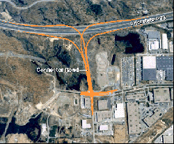
I-93 Interchange project
b.
Regional transportation center
c.
Extension of Commerce Way to Presidential Way
a.
The Massachusetts Highway Department of the Federal Highway
Department will create a new exit off Interstate 93 for the site
(figure 16b). The off-ramp will cost $15 million, and
construction started mid-August 1997. The I-93 project is listed
as one of Massachusetts Highway Department’s (MHD) highest
priority projects. The project has been designated a “fast
track” MHD project, where state and federal highway
transportation funds will cover 95% of the costs for the
interchange. In order to build the new highway interchange and
connector road, 1.2 acres of waterways and wetlands needed to be
filled at different locations. Creation of 1.35 acres of
compensatory wetlands has been proposed as mitigation to the U.S
Army Corps of Engineers.
b.
In fall 1996, several Massachusetts transportation agencies
announced that they would build a major Regional Transportation
Center (RTC) on the site (figure 17).The redevelopment work for
the regional transportation system will be incorporated into the
coverage phase of the site remediation. In other words, the
development of the site itself becomes part of the remedy. The
parking lot that will be situated adjacent to the regional
transportation center qualifies as a permanent covering remedy,
saving on coverage materials.
Figure
17: RTC, interchange and wetlands

Figure
18: Extension of Commerce Way
Figure
19: Quarry Pond

This center is
being funded by the State of Massachusetts. Located on a parcel
of land adjacent to the MBTA Lowell Line, the transportation
center will provide a 2,500-car park-and-ride and links to
subway, commuter rail and Logan Airport shuttlebus connection.
This center will be operated by the MBTA and the Massachusetts
Port Authority. The Transportation Center will be of particular
importance to the region, as it will help meet critical regional
transportation needs. It also will help with traffic problems
associated with the central artery. Construction started on the
Center during spring of 1997, after the owner of the 20 acre
property, Janpet Associates, declared bankrupcy.
c.
The extension of Commerce Way will provide currently nonexistent
access to north Woburn (figure 18).
8.
Redevelopment considerations
Some
parts of the site that might need to be developed are vegetated
areas with wetlands and rare species such as the Mystic Valley
Amphipod, a state-listed species of special concern believed to
live on the site. Though their presence could not be verified
through samples of juvenile crustaceans, a biologist has
confirmed that they live in wetlands on Parcel B shown in Figure
17, and the report adds “the tiny critters prefer
cool, shaded places” as their habitats. Parcels A and
B are shown in figure 20.
A
quarry pond shown in figure 19 adjacent to the Phillips pond will
be filled in to make the area more attractive to retailers. Under
current regulations the quarry is technically defined as a
wetland, these regulations prohibit building within 100 ft of
wetlands and state environmental laws require that any modified
wetland will have to be replicated with a new wetland of the same
dimensions elsewhere on the site. Therefore, in conjunction with
the project, the trust that governs the Industri-Plex will
construct a new body of water with similar surface areas to
compensate for the loss of the quarry. Wetland replacement and
construction in general will temporarily displace the animals.
But because the species currently inhabiting the area are
particularly tolerant to human activities, after the work is
completed the potential habitat for the local species can be
restored to its previous conditions.
9.
MetroNorth Development
A
development company, National Development of New England (NDNE),
has purchased parcels A and B which account for almost half the
Industri-Plex site and some adjacent properties for $100 million.
NDNE
has assembled approximately 103 acres of land on both sides of
the proposed interchange. A master development agreement
negotiated by NDNE with the City of Woburn and the Commonwealth
of Massachusetts serves as the framework and legal agreement to
develop infrastructure and improvements serving this area.
Construction of office, retail, and hotel facilities has begun.
The mixed-use development plan includes:
MetroNorth Corporate Center Parcel B shown in figure 20)
a.
1,000,000 square foot office development
b.
150-room hotel on 75 acres.
MetroNorth Retail Center(Parcel A shown in figure 20)
a.
60,000 square foot retail center
b.
135,000 square foot Target Department Store development.
Figure
20: Parcels A & B and Mishawum Rail Station
Figure
21: Proposal showing maximum building area for parcel B

MetroNorth Corporate Center
(Parcel B)
A
75-acre project will be developed with up to 1,000,000 S.F. of
office space and a hotel. Twenty-three acres of the land (Parcels
C1 and C2 in figure 21) are fully permitted with drainage design
and MEPA approval in place. Eleven acres will be permitted to
accommodate ArQule, a 260,000 square foot campus to be developed
in two phases of 130,000 square feet each. Parcel C2 is a fully
permitted 10-acre parcel which can be developed with up to a
three story, 150,000 square foot building slated for completion
in the spring/summer of 1999.
NDNE
is in the process of securing final state permits for parcel B.
Based on the current schedule, permitting should be completed by
the fall of 1998. Site plans can then be permitted on a parcel by
parcel basis. Delivery of new space could be accomplished on
Parcel B in the next 2 years.
MetroNorth Retail Center
(Parcel A)
Target
Stores has bought parcel A, the 27-acre tract off Commerce Way.
The city of Woburn received $227,000 in partial payment of back
taxes on the land as part of the $11.5 million agreement between
Target and the land's trustee. The store will take up about
135,000 square feet, also two smaller retail stores totalling
64,5000 square feet and up to 1,000 parking spaces will
eventually be built there.
The
sale has put the land, and eventually the new building itself,
back on Woburn's tax rolls. The completion of the store is
depending on the the completion of the interchange which will
drop traffic off nearly in front of the parcel at the
intersection of Commerce Way and Atlantic Avenue.
Current Use of Parcels A
& B:
· Commercial,
light industrial use and access: 60 acres
· Undeveloped
land: 185 acres
Future Use of Land:
· Commercial
development: 110 acres
·
Infrastructure/public transportation 25 acres
· Wetland and
open land (environmental enhancement programs): 100 acres
The
developer will also incorporate existing buildings and
facilities, including:
a. 510,000 square
foot Commerce Way Business Center, which will be renovated;
b. Commuter rail
lines;
c. Subway lines;
d. Local roads.
10.
Technical Containment Problems
After
nearly a decade, the containment is nearly completed and
development has begun, but there are several concerns. Concerns
were raised during the containment activities over the quality of
the soil used to cover the contaminated land and the soil-testing
procedures. Over half of the fill came from Deer Island, where
some sites had proven to be contaminated. Once the coverage is
complete it will be subject to random EPA tests. The final cover
has not received final certification from the EPA.
Woburn’s
Citizen Advisory Committee raised questions over the alternate
design cover proposed by the Remedial Trust. The EPA initially
recommended a 30-inch RD/AP cover. It consisted of 24 inches of
fill topped by 6 inches of loam and vegetation (figure 22). This
design would have cost twice as much as a geo-textile fabric
textile. So an alternate cover design was implemented. This cover
replaces 12 inches of soil with a geo-textile filter fabric, a
bottom barrier to the cover and there would be 12 inches of soil
minimum (figure 23). The most important issues for the alternate
cover were the safety factors for freeze-thaw effects, durability
as well as quality control.
Figure
22: EPA recommended design
Figure
23: Actual design implemented
Allegations
of improper conduct during the construction of the remedial cap
were under investigation by several government agencies. A former
site worker had filed suit alleging improper conduct during the
construction activities. Charges have been brought against the
firms in charge of implementing the cleanup for discharge from
the Industri-Plex site into streams and drainways. In one case,
during the day shift, when EPA supervisors were on site, water
from the site was pumped into tanker trucks so that it could be
transported for treatment at an off-site plant. But during the
night a witness claimed to have seen workers pumping water
into the drainway that empties into the Aberjona River.
Groundwater
contamination beneath, and migrating, from the site has not yet
been addressed by the EPA, MA DEP or responsible parties. Reduced
oxygen conditions in groundwater, caused by the presence of the
animal hides beneath the cap, cause arsenic and chromium to
become soluble in groundwater. Estimates point that 200 kilograms
of arsenic are released from the site and transported along the
Aberjona River to the Mystic Lakes, a mechanism which could
continue for centuries, an issue the firms in charge of the
cleanup are still studying.
The
Record of Decision for the Industri-Plex site, and the Consent
Decree between the EPA and the responsible parties requires that
Institutional Controls be developed to define construction and
reuse activities on the property. These may place restrictions on
construction and development. The Institutional Controls have not
been reviewed and approved yet, even though the sale of the
lots has already started.
Soil
contamination inside the Industri-Plex site property boundary has
been well documented in numerous reports since the early 1980s.
However, to date no attempt has been made by the EPA, MA DEP, or
the responsible parties to characterize the extent of
contamination outside the property boundary, which could pose a
health risk. Some residual contamination has been found off site,
south of the Boston Edison right-of-way but it hasn't been
determined yet if it is a health or environmental hazard.
Questions
were raised over the waiver of the of an impact study relative to
the proposed new ramp from I-93. To speed up the construction of
the interchange due to development pressures, submission of
the environmental impact studies was waived.
11.
Other redevelopment examples
1.
Iron Horse Park in Billerica, a onetime rail maintenance yard.
One owner, Guilford Transportation Industries, is cleaning up its
portion and plans to use it as an industrial park.
2.
Arsenal Mall in Watertown, which the developers opened in 1983
after reclaiming from an abandoned World War II weapons factory.
3.
Pesticide repackaging plant in Caribou, Maine, which is being
cleaned and will likely reopen as retail space.
Appendix A: Chronology of events
Mid-1800s-1934
– Developed as industrial site by companies who produced
chemicals for local textile, leather, and paper manufacturing
industries. Also used to manufacture munitions during WWI.
1934-1969
– Glue manufactured at site utilizing tanned animal hides.
Solid wastes disposed in pits, waste water discharged to streams,
later to sewers.
1968
– Mark Phillip Trust purchased site for development of
Industri-Plex 128 industrial park.
1970s
– Construction activity for the industrial park uncovered
the industrial by-products and wastes that had accumulated on the
site. The exposure and movement of decaying hides buried during
past site activities caused the release of noxious odors, similar
to a rotten egg smell. Many of the chemical and hide wastes in
the soil were relocated and mixed into piles near and in wetland
areas on the property.
1975
– Citizens complained to state agencies about odors. Dept.
of Environmental Quality Engineering (now the Dept. of
Environmental Protection, or DEP) issued numerous notices
violation to the developer.
1977
– Lawsuit by the Town of Reading and the Massachusetts
Attorney General resulted in a court order prohibiting the
developer from excavating two untouched parcels thought to
contain most of the remaining glue wastes.
1979
– U.S. Army Corps of Engineers stops further development on
site for wetlands issues.
1980
– DEP sprayed latex cover over part of the site where
inorganic wastes were found.
1982
– EPA adds Industri-Plex Site to its list of priority
hazardous waste sites that are eligible to receive federal
funding for investigation and clean up.
1982
– Study conducted on nature and extent of contamination on
site.
1985
– Remedial Investigation/Feasibility Study completed,
analyzing nature and extent of contamination and outlining
alternatives for remediation.
1986
– EPA issued record of Decision (ROD), which outlined
remedial alternatives and EPA’s preferred remedy for the
site.
1989
– Consent decree issued by EPA which included outcome of
negotiations with past and present site owners to determine cost
sharing of remediation. The Industri-Plex Site Remedial Trust and
the Industri-Plex Site Interim Custodial Trust are established as
part of the decree. The Remedial trust is made up of 22 past and
present owners and operators.
1990
– EPA approved Pre-Design Investigation, outlining what
information the Industri-Plex Site Remedial Trust had to collect
to proceed with design of remediation process. Additional testing
carried out. City rezoned the site from office to industrial use.
1991
– Final plans for the remediation filed with EPA and DEP.
1992
– design of the final soil remedy completed.
1993
– EPA and DEP approve soil remedy. Physical work on
remediation process begins.
1996
– Remediation of the site completed. Remediation cost: $70
million. Duration: 7 years.
Appendix B: DATA for the project
Data for the Case
Study on the Industri-plex site is in two forms:
1) Hardcopy plans and reports; and
2) CAD files on the Department of Civil and Environmental
Engineering server.
Access to the hardcopy plans and reports will be available at Barker Library Reserve desk.
Reports include:
1. Environmental Notification Form (June 1995)
2. Feasibility Study (August 1995)
Drawings include:
1. Location of work
2. Existing conditions
3. Details of soil cap
4. Location of utilities
5. Existing buildings and site layout.
Access to the CAD files will be through read-only access (although it can be copied into your account). All the figures along the text plus, additional images and the Cad files can be downloaded from the class web page (http://command.mit.edu/1.012).
List of material on reserve at Barker Library
Drawings:
REGIONAL TRANSPORTATION CENTER ALTERNATE COVER DESIGN
C-1A - Industri-Plex site location ofwork
and 1996 work areas.
C-2 - Existing conditions plan
C-2A - Compilation of historical utilities
C-2B - Compilation of existing utilities (1/2)
C-2C - Compilation of existing utilities (2/2)
C-2D – Pre-remediation extent of arsenic lead and chromium
at or above action levels
C-3 - Demolition plan
C-4 - Excavation plan
C-5 - EPA/DEP approval
C-5A – Layout plan
C-6 - Erosion control plan
C-7 - Erosion and sediment control details
C-8 - RTC site final grading and drainage plan
C-9 - Alternate cover transition plan
C-10 – Alternate cover transition details (1/3)
C-11 - Alternate cover transition details (2/3)
C-12 - RTC site transition details (1/2)
C-13 - RTC site transition details (2/2)
C-14 - Alternate cover details (1/2)
C-15 - Alternate cover details (2/2)
C-16 – Site details (1/3)
C-17 – Site details (2/3)
C-17A– Site details (3/3)
C-18 - Site sections (1/3)
C-19 - Site sections (2/3)
C-20 - Site sections (3/3)
Reports:
REGIONAL TRANSPORTATION CENTER
Feasibility Study
Environmental Notification Form
Summary of Proposed Institutional Controls
1. Geological
studies
1.1. Plan showing sections
1.2. Section A-A
1.3. Section B-B
1.4. Section C-C
1.5. Section D-D
1.6. Section E-E
2. Topographic map
3. Orthographic map