 In August of 1959 a magnitude 7.5 earthquake caused changes to the surface topography at Hebgen Lake and the Madison River valley. Movement on a normal fault inundated the north side of Hebgen Lake and exposed lake bottom on the south side. Evidence of this displacement is seen in the 20 foot high fault scarp north of Rt 287 at Cabin Creek.
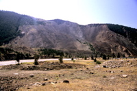
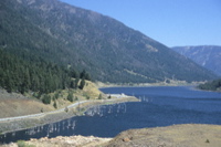
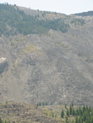
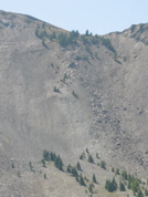
The Madison River flows west out of Hebgen Lake, and the earthquake caused a landslide on the southern slope of its canyon. The large amount of debris filled the canyon, ran 450 feet up the north side, damned the river, and created a new lake. The landslide scar is still barren and easily visible today at the Earthquake Lake Visitor Center. The current level of Earthquake Lake is determined by the continuing erosion in the man-made spillway, created immediately after the quake to control the rising water and safeguard the damn at Hebgen Lake.