Dayton, OH
General Description (1919 report):
"Dayton, Ohio, is located in the southwestern part of the State on moderately level land backed up by broken hills, at the confluence of the Mad and Stillwater Rivers with the Miami. Its population in 1910 was 132,000 and in 1918 was estimated at 175,000. Of this number 160,000 was considered permanent.
"There were over 200 industries in the city, 50 of which were on war work. The manufacturies were making tractors, small tanks, airplanes, gas shells and fuses for the Army, gun mounts and sights for the Navy, and engine parts for the Shipping Board. In 47 industries it was gound that there were 38,000 employees, and the increase needed for these factories was over 7,000. One of the principal industries for which housing was required was the Dayton-Wright Airplane Co., Where the number of employees was at that time 2,800, and it was proposed to increase that number to 4,000.
"Two housing sides were selected, one known as the Edgemont tract, located in the southern part of the city, and the other, known as the Leo Street tract, in the northern part, near the Maxwell plant and McCook Aviation Field."
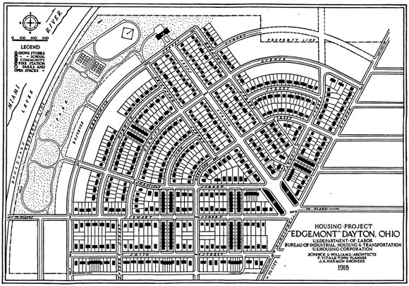
1919 excerpt describing the design of the Dayton Edgemont project:
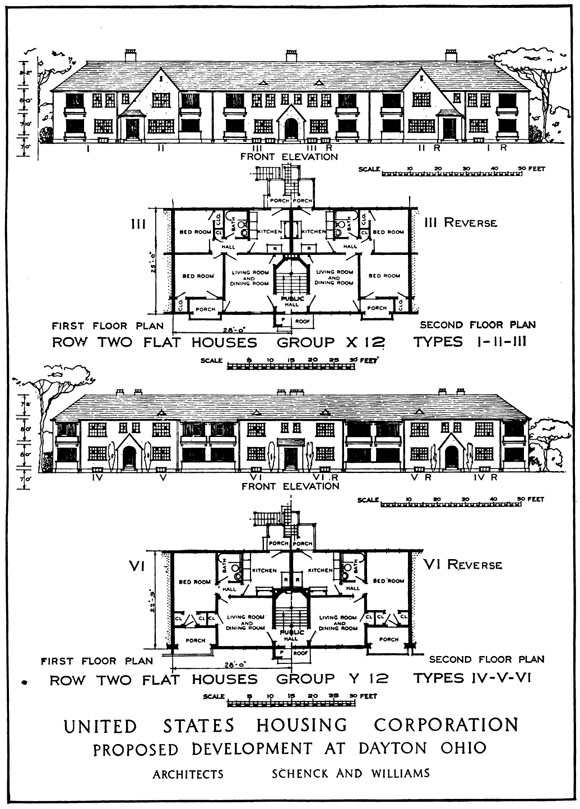
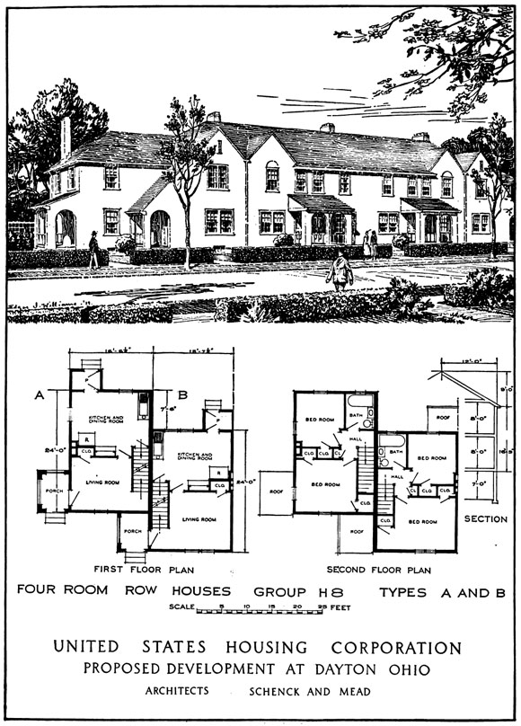
Area Planned: 107.95 acres. Housing planned: Detached houses, 175 families; semidetached houses, 296 families; row houses, 34 families; detached two-flat houses, 122 families; row two-flat houses, 160 families. Total, 787 families.
"The Edgemont site was chosen as the most convenient and economical tract suitable to a consistent development or the required size. It is within walking distance of two of the Ohmer plans and that of the National Cash Register Co., while a car passing the Cash Register plant runs to the Wright Airplane factory. Another car goes to the plants in North Dayton in 35 minutes, while tranfers will take one to the east and west in the same time. The site lies between Cincinnati Avenue, Stewart Street, and the new Miami levee...The land is mixed river deposit, generally sloping down toward the levee, but irregular as the water currents of former floods have left it. A considerable portion is high enough to offer no particular development difficulties. The part next to to the levee, however, is low, and most of the site was inundated in the flood of 1913. It was expected, however, that if the housing were first built on the higher ground, by the time that the lowest land was developed the levee in Dayton and the dams in the Miami River would have been far enough completed to protect the houses from damage by high water. Some of this low area was planned to be used, without much regrading, as a playground; the rest could be developed for housing at the cost of additional sewer construction..."
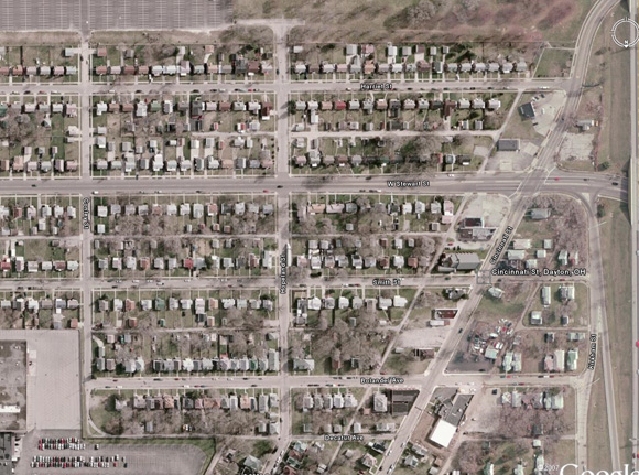
The Dayton Edgemont Site Today
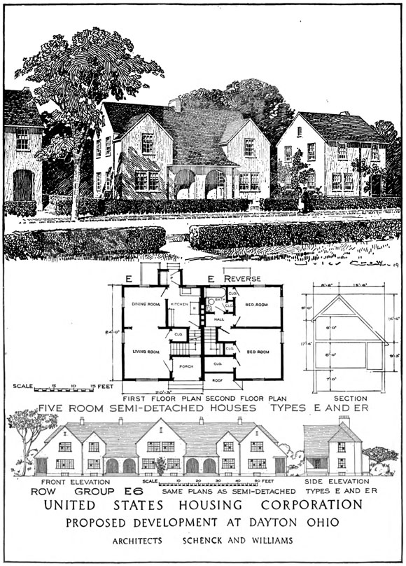
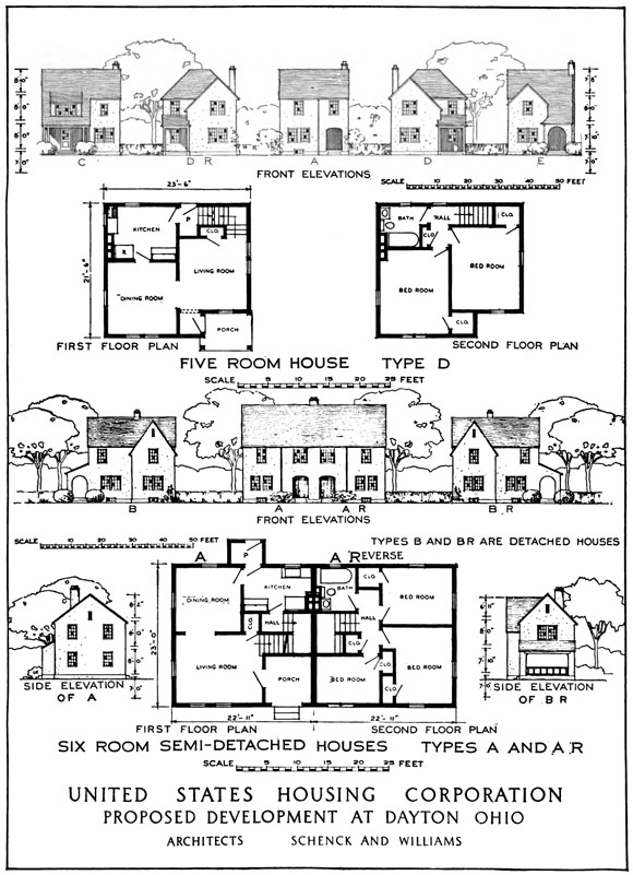
Renderings, 1919

1919 excerpt describing the design of the Dayton Leo Street project:
Area planned:3.34 acres. Housing planned: Semidetached two-flat houses, 40 families.
"The smaller Leo Street site was on land already plotted and to some extent sold in private lots though not much built upon. A new lotting scheme was made for that part of the site which was to be immediately developed, and a simple layout scheme for a larger area was planned, by the armistice pu an end to all activity on both sides."