![]()
May 1997
2Joint Program on the Science and Policy of Global Change, MIT,
Cambridge, MA 02139
3Institute of Arctic Biology, University of Alaska, Fairbanks, AK
99775
4Institute for the Study of Earth, Ocean and Space, Univ. of New
Hampshire, Durham, NH 03824
View Report as PDF file (warning: large file size: 5.7 MB!)
Contents:
The United Nations Food and Agriculture Organization (FAO) has developed the Agro-Ecological Zone approach to assess land suitability for croplands at local and national scales, which is based on climate, soil and crop characteristics. [7-9] The approach has been further applied at the global scale. [10, 11] By modeling the global distribution of potential croplands under contemporary climate and under doubled CO2 equilibrium climates generated by four atmospheric general circulation models (GCMs), Cramer and Soloman [11] found that climate change significantly affects the area and spatial distribution of land that can potentially be used for crop production. However, topographical constraints on cropland distribution were not included in the above studies, and consequently the area of potential croplands is likely to be substantially overestimated.
In this study, we develop a cropland distribution model that includes climate,
soil and topography constraints on the distribution of potential croplands. We
apply the model to estimate the area and spatial distribution of potential
croplands of the world under contemporary climate. To assess the effect of
transient climate change on potential croplands, we use three transient climate
change predictions over the period of 1977-2100 from the MIT Global System
Model for integrated assessment of climate change.
[12]
The MIT framework (Fig. 1)
includes the Anthropogenic Emission Prediction and Policy
Analysis (EPPA) model,
[13]
an atmospheric chemistry model,
[14]
a two-dimensional climate model (MIT 2-D L-O climate model
[15-19])
, a terrestrial biogeochemistry model (the Terrestrial Ecosystems Model
[19-22])
and natural emission models of
N2O and CH4 from soils.
[23]
The EPPA model
projects anthropogenic emissions of CO2 and other greenhouse gases
(e.g., N2O and CH4) in the twelve economic regions
of the world. We examine the spatial and temporal dynamics of potential
croplands at the scales of the globe, economic regions and grid cells.
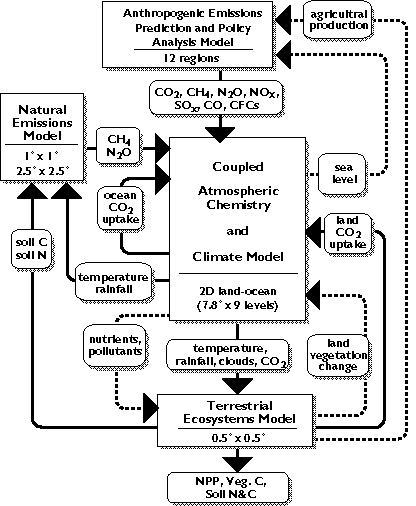
Figure 1. A schematic diagram illustrating the framework and components
of the MIT Global System Model for integrated assessment of climate change. The
linkages and feedbacks between the component models that are currently included
or under development for future inclusion are shown as solid and dashed lines,
respectively.2. Cropland Distribution Model
2.1 Climate constraints| Contents |
Heat and water requirements of crops determine the spatial distribution
of potential croplands. In a correlation analysis between the map of
croplands
[24]
and maps of climate variables generated from the IIASA
database of contemporary climate,
[25]
Cramer and
Soloman[11] defined a climate envelope of potential croplands: equal
or greater than 2000 growing degree days (0 degrees C base), a ratio of actual
evapotranspiration over potential evapotranspiration (AET/PET) greater than
0.45; excluding those areas that have a temperature of greater than 15.5
degrees C in the coldest month and a AET/PET ratio of greater than 0.70, where
potential severe soil erosion in croplands would limit crop production. The
climate envelope has been used in a few global studies.
[10, 11]
We also use the climate envelope of Cramer and Soloman[11] to define climate-based potential croplands in our study, although our procedures to calculate growing degree days and AET/PET ratios are slightly different from Cramer and Soloman. In our study, monthly mean temperature data are linearly interpolated to daily mean temperature, which are then used for calculating growing degree days. We use the water balance model of Vorosmarty et al., [26] which has been incorporated into our Terrestrial Ecosystem Model (TEM [12, 19-22] ) to estimate PET and AET. The water balance model runs at monthly time step. The input variables of the water balance model include elevation, soil texture (proportion of sand, clay and silt), monthly climate (temperature, precipitation and cloudiness) and vegetation types. Elevation is used to determine snowmelt dynamics of a grid cell (snowmelt occurs in one month if elevation is below 500 m; snowmelt occurs in two months if elevation is above 500 m). Soil texture affects the field water-holding capacity and wilting point of soils. The monthly flux PET is calculated as a function of monthly mean air temperature and solar radiation. [27] The flux of AET is equal to PET in wet months but is modeled as a function of rainfall, snowmelt recharge and a change of soil moisture in dry months.[26] The ratio of AET/PET for each of twelve months is calculated. For moist tropical regions where temperature in the coldest month is greater than 15.5 degrees C, we assume that a grid cell will not be suitable for croplands if there are more than eight months in a year that have a AET/PET ratio greater than 0.70.
For defining mountains from elevation data, we designed a pattern search algorithm within a window that has 3 x 3 grid cells. We calculate elevation differences between the center grid cell and each of its eight neighboring grid cells. We first recognize or stratify three topographical features of the world: plains with low elevation (approximately lower than 500 m in elevation); low mountains and low plateau (approximately lower than 1000 m in elevation); high mountains and high plateau (e.g., Rocky mountains in north America, Andes in south America, Himalayas mountains, Qinghai-Tibet plateau in China). Then, we apply the following criteria to decide whether the center grid cell is mountain: (1) elevation difference is greater than 400 m, when elevation of the center grid cell is less than 500 m; (2) elevation difference is greater than 600 m, when elevation of the center grid cell is within 500-1000 m; and (3) elevation difference is greater than 1200 m, when elevation of the center grid cell is more than 1000 m. If any of the eight elevation differences within a 3 x 3 window meets one of the criteria, then the center grid cell is assigned to be mountain. If a grid cell is assigned to be mountain, it will not be used for cropland, even if it meets climate constraints for croplands. We used this 3 x 3 window pattern search for all the grid cells in our global elevation database, [29] which has a resolution of 0.5 degrees longitude x 0.5 degrees latitude grid. The resulting global map of mountain (Fig. 2) clearly shows large mountain ranges, e.g., Rocky, Andes and Qinghai-Tibet plateau. In a visual qualitative comparison, the geographical distribution of mountains in our global map of mountains mimics well with a shaded relief image of global topography, [30] which was generated from an elevation data set (NOAA's ETOPO5) with a spatial resolution of 5 minutes latitude by 5 minutes longitude.
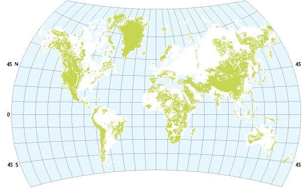
Figure 2. Spatial distribution of mountains in the world. Note that
Greenland is mostly covered with ice. 2.3 Data for global extrapolation | Contents |
The spatial data sets used for a global extrapolation of the cropland
distribution model are organized at a resolution of 0.5 degree longitude x
0.5 degree latitude grid, including elevation,[29] soil
texture,
[31]
vegetation types
[21]
and long-term average
contemporary climate from the Cramer and Leemans CLIMATE database (Wolfgang
Cramer, person communication), which is a major update of the IIASA Climate
database.
[25]
Of the 62,483 land grid cells in these spatial data
sets, there are 3,059 ice grid cells and 1,525 wetland grid cells (e.g.,
mangrove, swamp, salt marsh and flood plains). Thus, the global land area used
in this study is 133.56 x 10⁶ km2, i.e., 130.31 x
106 km2 upland and 3.25 x 10⁶ km2
wetlands. In calculating potential croplands, we exclude those grid cells that
are wetland in the vegetation data set.[21] We run the cropland
distribution model using the above global data sets to estimate spatial
distribution of potential cropland under the contemporary climate.
The MIT 2-D L-O climate model simulates the zonally averaged climate
separately over land and ocean as a function of latitude and height. It has 23
latitudinal bands, corresponding to a resolution of 7.826 degrees , and nine
vertical layers. The climate outputs in the 23 latitudinal bands from the MIT
2-D L-O climate model were first linearly interpolated to 0.5 degrees
resolution, and the interpolated values were then applied to all the grid cells
within a 0.5 degree latitudinal band. In generating "future climate" we
calculated absolute differences in monthly mean temperature and ratios in
monthly precipitation and monthly mean cloudiness, using the simulated climate
data in 1977 from the MIT 2-D L-O climate model as the control values. Then, we
added the absolute differences in monthly mean temperature over the period of
1978-2100 to the contemporary monthly mean temperature data, and multiplied the
ratios in monthly precipitation and monthly mean cloudiness over the period of
1978-2100 by the contemporary monthly precipitation and monthly mean cloudiness
data, respectively.
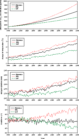
Figure 3. Projected changes in global annual mean atmospheric
CO2 concentration (ppmv), global annual mean temperature (degrees C),
global mean daily precipitation (mm) and global annual mean cloudiness (%) over
the period of 1977-2100 for the Reference, HHL and LLH scenarios by the MIT 2-D
L-O climate model (see reference [12] for details). 3. Results and Discussion
3.1 Potential croplands under contemporary climate | Contents |
The cropland distribution model estimates that the area of global
potential croplands under contemporary climate is about 32.91 x 10⁶
km2, approximately 25.3% of the global land area (130.31 x
106 km2). This estimate is significantly lower than the
global estimate of 41.53 x 10⁶ km2 potential croplands by
Cramer and Soloman,
[11]
who modeled the potential cropland
distribution using contemporary climate data.
[25]
This difference is
primarily attributed to the fact that topographical constraint is taken into
account in our cropland distribution model, and indicates that topography is
important in determining potential croplands. Our estimate is about 36.4%
higher than the estimate of croplands (about 24.12 x 10⁶ km2
) of Olson et al.
[24]
and is close to the estimate of
croplands (about 32.05 x 10⁶ km2 ) of
Matthews.
[33]
Olson et al. and Matthews estimated global
croplands by compiling map data from various data sources and available maps.
For global distribution of croplands, Olson et al. uses a 0.5 degree x
0.5 degree resolution grid and Matthews uses a 1.0 degree x 1.0 degree
resolution grid. Note that the above four estimates of potential cropland area
are obtained with an assumption that a grid cell is 100% used for croplands if
it is suitable for cultivation. In reality, the percent area used for croplands
within a grid cell (i.e., cultivation density) varies among grid cells
and is most likely much lower than 100%, because of human settlement
(e.g., urban, villages), infrastructure and other types of land use.
According to the FAO country statistics of cultivation,
[34]
approximately 15 x 106 km2 area was actually growing crops
in 1984.
Potential cropland area varies substantially among the twelve economic regions of the world used in the EPPA model (Fig. 4). The ratio of potential cropland area over total land area for each of the economic regions indicates the potential of land for cultivation. The ratio varies from 11.1% in the Energy Exporting Countries (EEX) economic region to 77.7% in the Eastern European Countries (EET) economic region (Fig. 4). The EEX and the Rest of the World (ROW) economic regions have large areas of desert and semi-arid land, where there is not enough precipitation to support rain-fed agriculture. The Former Soviet Union (FSU) and the Other OECD Countries (OOE) economic regions have large areas of land in high latitudes where the temperature is too low for crops to grow. China has the largest population in the world but a low ratio of potential cropland area over total land area, because China has large areas of mountains (Fig. 2), dry land (e.g., Mongolia plateau, Gobi desert in northwestern China) and the cold Qinghai-Tibet plateau.
Actual cropland areas among the twelve economic regions in 1980, which are
derived from the FAO country statistics data of crop cultivation and
production,
[35]
vary considerably (Fig. 4), partly because of the
differences in population and agricultural practices. The ratio of actual
cropland area over potential cropland area indicates the realized potential of
land used for cultivation (Fig. 4). The ratio ranges from 25.0% in Brazil to
109.7% in India. Only five economic regions (Brazil, Japan, OOE, FSU, and USA)
have a ratio lower than 50%. The low ratio in Brazil indicates that Brazil has
a large amount of potential croplands for future use. The highest ratio in
India indicates that people in India have already practiced crop cultivation in
a fair amount of mountainous regions and other marginal lands. However, crop
cultivation in mountains is generally very vulnerable to severe soil erosion
and low slope stability in mountains, especially on long-term temporal scales.
As shown in Fig. 5, our cropland distribution model represents reasonably well
the spatial distribution of global croplands as described in the map of
croplands of Olson et al.
[24]
The agreement between Olson
et al. and our model occurs in 6266 grid cells, about 14.35 x
106 km2, which accounts for 59.5% of the global cropland
area estimated by Olson et al. Olson et al. includes irrigated
croplands, thus, a fair amount of croplands described by Olson et al. is
located in semi-arid and arid regions. We have not included global river
networks in this study and thus we can not project those croplands that are
completely dependent upon irrigation from river water, e.g., the Nile
River (Fig. 5). A large area of croplands in the western United States is also
dependent on irrigation water from aquifers.
The geographical distribution of potential croplands (Fig. 5) is closely
correlated with the geographical distribution of human population (Fig. 6).
Potential croplands occur mostly in those areas that have population densities
of five or more people per square kilometer. Among the twelve economic regions,
India and China have the highest population densities, indicating the highest
pressure on potential croplands to be converted for crop cultivation. The
cropland model estimates that large portions of moist tropical forests in
Brazil, tropical Asian countries (e.g., Philippine, Indonesia and
Malaysia) and Africa are not good for croplands due to the potential of severe
soil erosion in croplands (Fig. 5). In the map of Olson et
al.,[24] there are only small areas of croplands in the moist
tropical forests in Brazil but fair amounts of croplands in the tropical Asian
countries where irrigated rice paddy dominates (Fig. 5). The difference between
Brazil and the tropical Asian countries may be attributed primarily to much
higher population pressure for crop production in the tropical Asian countries
from higher population density (more than 50 people per km2; see
Fig. 6) and secondarily to monsoon climate in Asia. Our cropland distribution
model estimates that a large portion of eastern Amazon is suitable for
croplands (Fig. 5), where extensive deforestation has been observed during the
1980s, with a fair portion of forest conversion to croplands and pasture. Skole
and Tucker
[36]
estimated that deforested area in Amazon is 78,000
km2 in 1978 but 230,000 km2 in 1988, using high
resolution LANDSAT imagery. Deforestation in tropical regions is closely driven
by increases in human population and other social-economic factors across
local, regional, national and international levels.
[37-39]
In this study, our cropland distribution model has not included the spatial
distribution of human population. The comparison in geographical distributions
between potential croplands and human population indicates that further studies
are needed to quantify the relationship between cropland distribution and
spatial distribution of human population. Thus, future work needs to
incorporate the spatial-temporal dynamics of human population into our cropland
distribution model for estimating distributions of actual croplands. Further
studies are also needed to investigate the relationship between croplands and
monsoon climate, especially in the above tropical Asian countries.
The increase in global potential croplands is mostly attributable to
increases in potential croplands of the Former Soviet Union and the Other OECD
Countries economic regions (Fig. 8). The other ten economic regions have little
change in the area of potential croplands. China may even have a small decrease
in the area of potential croplands by the end of 21st century. The relative
contributions among the 12 economic regions to the increase of global potential
croplands are similar for these three climate change predictions (Fig. 8).
Human population is likely to increase substantially in developing countries,
e.g., China, India, and the ROW economic regions, while developed
countries (e.g., USA, EEC, OOE and FSU economic regions) have a small
increase in population (Fig. 9). Human populations in the Dynamic Asian
Economics, the Energy Exporting Countries and Brazil economic regions (Fig. 9)
also increase faster than the increase in potential croplands (Fig. 8). For
developing countries, the opposite trends in population and potential cropland
area indicate an increasing pressure to raise agricultural production per unit
area. These developing countries, however, are under the largest constraints in
energy and resources, which are essential for intensive agricultural
production. Future climate change and an increase of atmospheric CO2
concentration are also likely to affect crop production
significantly.
[40-42]
In a recent study that uses comparable crop
yield models with doubled CO2 equilibrium climate changes from three
GCMs (GISS, GFDL, UKMO) to assess the potential impacts of climate change on
world food supply, the results suggest that doubling of atmospheric
CO2 concentration will lead to a small decrease in global crop
production.
[42]
Climate change increases cereal production per
hectare in the developed countries but reduces cereal production per hectare in
developing countries.[42] One important implication from the
comparison among population dynamics, potential cropland area dynamics and crop
production per hectare is that international trade in agricultural products
will have to be substantially increased between developed countries and
developing countries, in order to avoid food shortage in some countries in the
21st century.
Figure 10. Changes in the spatial distribution of global potential
croplands over the period of 1977-2100 under the Reference transient climate
change prediction. Percentages in the color legend represent the number of
years a grid cell is suitable for cropland over the 124-year simulation in the
study.
The potential expansion of croplands into high latitudes in the northern
hemisphere in the 21st century may have a significant impact on the global
carbon budget. Total carbon storage (vegetation carbon plus reactive soil
organic carbon) under contemporary climate at 315 ppmv CO2 has a
bimodal distribution along 0.5 degree latitudinal bands (Fig. 13). Of 1658.6
PgC (1015 g C) total carbon storage of the terrestrial
biosphere,
[19]
423.6 Pg (25.5%) is stored within the tropical
latitudes (10 degrees S to 10 degrees N) where tropical forests dominate, and
420.8 PgC (25.4%) is stored within the 45 degrees N to 65 degrees N latitude
band, where boreal forests and tundra dominate. In tropical forest ecosystems,
vegetation carbon is substantially higher than reactive soil organic carbon,
while a large portion of carbon in boreal forests and tundra is stored in
soils. In calculating the effects of land cover and land use changes on the
historical and present global carbon budget,
[45, 46]
tropical deforestation plays a dominant role in CO2 emissions from land use
and land cover changes. Conversion of boreal forests and tundra into croplands
may also result in a large loss of carbon in vegetation and soils, and will
affect carbon flux and storage in the terrestrial biosphere. Our study implies
that the effort to stabilize atmospheric CO2 concentration in the
next centuries may also need to take into consideration the constraints of land
use and land cover changes at the mid- to high- latitudes of the northern
hemisphere.
The incorporation of a global large river network and spatial distribution of
human population into the cropland distribution model may improve our estimate
of croplands under contemporary climate and provide a basis to assess the
effects of water supply (particularly in semi-arid and arid regions) and
population dynamics on agriculture in the future. Further work is also needed
to model or delineate spatial distributions of various crops on the
globe
[10]
and to estimate yields of crops. A land use model, which
uses potential croplands and social-economic constraints, needs to be developed
to define the area and spatial distribution of actual croplands on the globe.
The linkage of a land cover and land use change model, a global terrestrial
biogeochemistry model (e.g., TEM) and a climate model will allow us to
assess the impacts of land cover and land use changes on global carbon and
nitrogen cycling as well as the feedbacks of land cover and land use changes to
atmosphere and climate over time (e.g., net CO2 fluxes,
albedo and roughness).
Acknowledgments
We thank B.L. Turner II, R.G. Prinn, J.D. Henry and R. Eckaus for
invaluable discussion and comments on the work and earlier versions of the
manuscript. G. Esser provided actual cropland data at country level in 1980
from FAO. This study was supported by the Joint Program on the Science and
Policy of Global Change at the Massachusetts Institute of Technology
(CE-S-462041), the National Institute of Global Environmental Changes of the
Department of Energy (No:901214-HAR), and the Earth Observing Systems Program
of NASA (NAGW-2669).
2. Naylor, R.L., 1996, Energy and resource constraints on intensive
agricultural production, Annual Review of Energy and Environment,
21, 99-123.
3. Bullock, P. and H. Le Houerou, 1996, Land degradation and desertification,
In: Climate Change 1995--Impacts, Adaptations and Mitigation of Climate
Change: Scientific-Technical Analyses, Contribution of Working Group II to
the Second Assessment Report of the Intergovernmental Panel on Climate Change,
R.T. Watson, M.C. Zinyowera, R.H. Moss and D.J. Dokken, (eds.), Cambridge
University Press, p. 171-189.
4. World Resource Institute, 1992, World Resources 1992-1993, Oxford
University Press, Oxford, UK, 385 p.
5. Bradbury, I., R. Kirkby G. and Shen, 1996, Development and Environment: the
case of rural industrialization and small-town growth in China, Ambio,
25, 204-209.
6. Douglas, I., 1994, Human settlements, In: Changes in Land Use and Land
Cover: A Global Perspective, W.B. Meyer and B.L. Turner II (eds.),
Cambridge University Press, New York, p. 149-169.
7. FAO, 1978, Report on the Agro-Ecological Zone project, Vol. 3,
Methodology and Results for South and Central America, World Soil
Resources Report, 48/3, FAO, Rome.
8. Brinkman, R., 1987, Agro-ecological characterization, classification and
mapping: Different approaches by the International Agricultural Centers, In:
Agricultural Environments. Characterization, Classification and Mapping,
A.H. Bunting (ed.), C.A.B. International, Wallingford, UK, p. 31-42.
9. FAO/IIASA, 1993, Agro-ecological assessments for national planning: the
examples of Kenya, FAO Soils Bulletin, 67, FAO, Rome.
10. Leemans, R. and A.M. Soloman, 1993, Modeling the potential change in yield
and distribution of the earth's crops under a warmed climate, Climate
Research, 3, 79-96.
11. Cramer, W.P. and A.M. Soloman, 1993, Climatic classification and future
global redistribution of agricultural land, Climate Research, 3,
97-110.
12. Prinn, R., H. Jacoby, A. Sokolov, C. Wang, X. Xiao, Z. Yang, R. Eckaus, P.
Stone, D. Ellerman, J. Melillo, J. Fitzmaurice, D. Kicklighter, Y. Liu and G.
Holian, 1996, Integrated global system model for climate policy analysis: I.
Model framework and sensitivity studies, Joint Program on the Science and
Policy of Global Change, Report No. 7, MIT, Cambridge, Mass., June, 76 p.
13. Yang, Z., R. Eckaus, D. Ellerman, J. Fitzmaurice and H. Jacoby, 1996,
The MIT Emission Prediction and Policy Analysis (EPPA) model, Joint
Program on the Science and Policy of Global Change, Report No. 6, MIT,
Cambridge, Mass., June, 49 p.
14. Wang, C., R. Prinn, A. Sokolov, P. Stone, Y. Liu and X. Xiao, 1995, A
coupled atmospheric chemistry and climate model for chemically and radiatively
important trace species, WMO-IGAC Conference on the Measurement and Assessment
of Atmospheric Composition Change, October, Beijing, WMO GAW No. 107,
182-184.
15. Yao, M.S. and P.H. Stone, 1987, Development of a two-dimensional zonally
averaged statistical-dynamical model. Part I: The parameterization of moist
convection and its role in the general circulation, Journal of the
Atmospheric Sciences, 44(1), 65-82.
16. Stone, P.H. and M.S. Yao, 1987, Development of a two-dimensional zonally
averaged statistical-dynamical model. Part II. The role of eddy momentum
fluxes in the general circulation and their parameterization. Journal of the
Atmospheric Science, 44(24), 3769-3786.
17. Stone, P.H. and M.S. Yao, 1990, Development of a two-dimensional zonally
averaged statistical-dynamical model. Part III. The parameterization of the
eddy fluxes of heat and moisture, Journal of Climate, 3(7),
726-740.
18. Sokolov, A.P. and P.H. Stone, 1995, Description and validation of the
MIT version of the GISS 2-D Model, Joint Program on the Science and Policy
of Global Change, Report No. 2, MIT, Cambridge, Mass., June, 46 p.
19. Xiao, X., D. Kicklighter, J. Melillo, A. McGuire, P. Stone and A. Sokolov,
1997, Linking a global terrestrial biogeochemical model and a 2-dimensional
climate model: Implications for the global carbon budget, Tellus,
49B, 18-37.
20. Raich, J.W., E.B. Rastetter, J.M. Melillo, D.W. Kicklighter, P.A. Steudler,
B.J. Peterson, A.L. Grace, B. Moore III and C.J. Vorosmarty, 1991, Potential
net primary productivity in South America: application of a global model,
Ecological Applications, 1, 399-429.
21. Melillo, J.M., A.D. McGuire, D.W. Kicklighter, B. Moore III, C.J.
Vorosmarty and A.L. Schloss, 1993, Global climate change and terrestrial net
primary production, Nature, 363, 234-240.
22. McGuire, A.D., J.M. Melillo, D.W. Kicklighter, Y. Pan, X. Xiao, J.
Helfrich, B. Moore III, C.J. Vorosmarty and A.L. Schloss, 1997, Equilibrium
responses of global net primary production and carbon storage to doubled
atmospheric carbon dioxide: sensitivity to changes in vegetation nitrogen
concentration, Global Biogeochemical Cycles, in press.
23. Liu, Y., 1996, Modeling the emission of nitrous oxide (N2O)
and methane (CH4) from the terrestrial biosphere to the
atmosphere, Joint Program on the Science and Policy of Global Change,
Report No. 10, MIT, Cambridge, Mass., August, 219 p. (Ph.D.
Dissertation)
24. Olson, J.S., J.A. Watts and L.J. Allison, 1983, Carbon in live
vegetation of major world ecosystems, ORNL 5862, Oak Ridge National
Laboratory, Oak Ridge, Tenn.
25. Leemans, R. and W.P. Cramer, 1991, The IIASA climate database for land
areas on a grid with 0.5 degrees resolution, Research Report RR-91-18,
International Institute for Applied Systems Analysis (IIASA), Laxenburg,
Austria, 60 p.
26. Vorosmarty, C.J., B. Moore III, A.L. Grace, M.P. Gildea, J.M. Melillo, B.J.
Peterson, E.B. Rastetter and P.A. Steudler, 1989, Continental scale models of
water balance and fluvial transport: an application to South America, Global
Biogeochemical Cycles, 3(3), 241-265.
27. Jensen, M.E. and H.E. Haise, 1963, Estimating evapotranspiration from solar
radiation, Journal of the Irrigation and Drainage Division, 4,
15-41.
28. Beniston, M. and D.G. Fox, 1996, Impacts of climate change on mountain
regions. In: Climate Change 1995--Impacts, Adaptations and Mitigation of
Climate Change: Scientific-Technical Analyses, Contribution of Working
Group II to the Second Assessment Report of the Intergovernmental Panel on
Climate Change, R.T. Watson, M.C. Zinyowera, R.H. Moss and D.J. Dokken (eds.),
Cambridge University Press, p. 191-213.
29. NCAR/NAVY, 1984, Global 10-minute elevation data, Digital tape
available through National Oceanic and Atmospheric Administration, National
Geophysical Data Center, Boulder, Col.
30. Sloss, P.W., 1996, Enhancing NOAA's image: imagery in print, on walls and
on the World Wide Web, Earth System Monitor, 7(1), 1-2,
September.
31. FAO-UNESCO, 1971, Soil map of the world, 1:5,000,000, UNESCO, Paris,
France. Digitization (0.5 degrees resolution) by Complex Systems Research
Center, U. of New Hampshire, Durham, and modifications by Marine Biological
Laboratory, Woods Hole of the IPCC IS92 Emission Scenarios, Intergovernmental
Panel on Climate Change, Cambridge, UK.
32. IPCC, 1994, Climate Change 1994: Radiative Forcing of Climate Change and
an Evaluation of the IPCC IS92 Emission Scenarios, Intergovernmental Panel
on Climate Change, Cambridge University Press, Cambridge, UK, p. 233-304.
33. Matthews, E., 1983, Global vegetation and land use: new high resolution
databases for climate studies, Journal of Climatology and Applied
Meteorololgy, 22, 474-487.
34. FAO, 1986, 1985 FAO Production Yearbook, Vol. 39, Food and
Agricultural Organization of the United Nations, Rome.
35. FAO, 1980, Production Yearbooks, Vol. 33, FAO Statistics Series No.
28, Food and Agricultural Organization of the United Nations, Rome.
36. Skole, D.L. and C.J. Tucker, 1993, Tropical deforestation and habitat
fragmentation in the Amazon: Satellite data from 1978 to 1988, Science,
260, 1905-1910.
37. Fearnside, P.M., 1993, Deforestation in Brazilian Amazonia: the effect of
population and land tenure, Ambio, 22, 537-545.
38. Kummer, D.M. and B.L. Turner II, 1994, The human causes of deforestation in
southeast Asia, Bioscience, 44, 323-328.
39. Skole, D.L., W.H. Chomentowski, W.A. Salas and A.D. Nobre, 1994, Physical
and human dimensions of deforestation in Amazonia, Bioscience,
44, 314-322.
40. Reilly, J., 1996, Agriculture in a changing climate: Impacts and
adaptation. In: Climate Change 1995--Impacts, Adaptations and Mitigation of
Climate Change: Scientific-Technical Analyses, Contribution of
Working Group II to the Second Assessment Report of the Intergovernmental Panel
on Climate Change, R.T. Watson, et al. (eds.), Cambridge University Press, p.
427-467.
41. Wittwer, S.H., 1995, Food, Climate and Carbon Dioxide: The Global
Environment and World Food Production, Lewis Publishers, New York, 236 p.
42. Rosenzweig, C. and M.L. Parry, 1994, Potential impact of climate change on
world food supply, Nature, 367, 133-138.
43. Mitchell, J.F.B., S. Manabe, T. Tokioka and V. Meleshko, 1990, Equilibrium
climate change and its implications for the future, In: Climate Change: The
IPCC Scientific Assessment, J.T. Houghton, G.J. Jenkins and J.J. Ephraums
(eds.), Cambridge University Press, New York, p. 131-164.
44. Kattenberg, A., F. Giorgi, H. Grassl, G.A. Meehl, J.F.B. Mitchell, R.J.
Stouffer, T. Tokioka, A.J. Weaver and T.M.L. Wigley, 1996, Climate models -
Projections of future climate, In: Climate Change 1995: The Science of
Climate Change, J.T. Houghton, L.G. Meira Filho, B.A. Callander, N. Harris,
A. Kattenberg and K. Maskell (eds.), Intergovernmental Panel on Climate Change,
Cambridge University Press, p. 284-357.
45. Esser, G., 1987, Sensitivity of global carbon pools and fluxes to human and
potential climatic impacts, Tellus, 39B, 245-260.
46. Houghton, R.A., 1996, Terrestrial sources and sinks of carbon inferred from
terrestrial data, Tellus, 48B, 420-432.
47. Tobler, W., U. Deichmann, J. Gottsegen and K. Maloy, 1995, The Global
Demography Project, National Center for Geographical Information and
Analysis, Technical Report
48. Bulatao, R.A., E. Bos, P.W.S. Stephens and M.T. Vu, 1990, World Bank
Population Projections, 1989-1990 Edition, John Hopkins
University Press, Baltimore, Maryland.
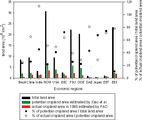
Figure 4. Total land area, potential cropland area under contemporary
climate, and actual cropland area in 1980 in the twelve economic regions of the
world. These 12 economic regions are defined in the Anthropogenic Emission
Prediction and Policy Analysis model (EPPA): DAE - Dynamics Asian Economics,
EEC - European Economic Community, EET - Eastern European Countries, EEX -
Energy Exporting Countries, FSU - Former Soviet Union, OOE - the Other OECD
Countries, ROW - the Rest of the World, USA - United States of America. Data of
actual cropland area in 1980 are aggregated from the FAO country statistics
data of agricultural production, which were provided by Dr. G. Esser. Note that
for Brazil, the ratio of potential cropland area over total land area is
overlapped with the ratio of actual cropland area over potential cropland area.
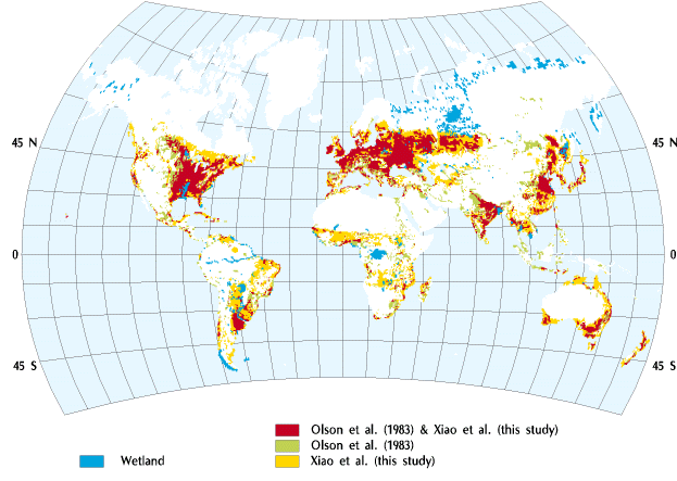
Figure 5. The comparison between the map of croplands of Olson et
al.[24] and the map of global potential croplands under
contemporary climate estimated by our cropland distribution model. In the map
of croplands of Olson et al., both cultivation and secondary vegetation
areas are included. Both maps have a spatial resolution of 0.5 degrees latitude x
0.5 degrees longitude.
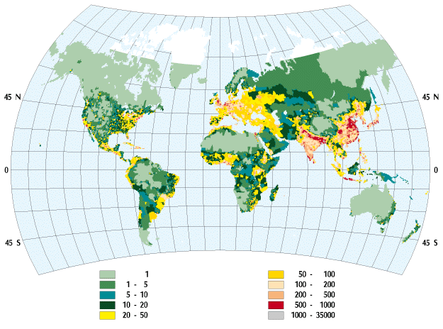
Figure 6. Geographical distribution of population density (number of
people per km2) of the world in 1994 at 0.5 degrees latitude by
0.5 degrees longitude resolution. It is aggregated from the Gridded Population
of the World at 5 minutes (latitude) by 5 minutes (longitude) resolution, which
is released by the Consortium for International Earth Science Information
Network (CIESIN) and the U.S. National Center for Geographical Information and
Analysis (NCGIA) in 1995 (see reference
[47]
and the web site http://www.ciesin.org). The unsmoothed population density data from the CIESIN
and NCGIA were used, which geographically cover areas from 57 degrees S to 72
degrees N.3.2 The effects of transient climate change on potential croplands | Contents |
The area of global potential croplands increases under the three
transient climate change predictions over the period of 1977-2100 (Fig. 7). The
large interannual variation in the area of global potential croplands shows the
effect of interannual variation of climate (Fig. 7). In 2100, the area of
global potential croplands increases about 11.5% (3.78 x 10⁶
km2) for the `Reference', 12.5% (4.12 x 10⁶
km2) for the `HHL', and 6.7% (2.20 x 10⁶ km2)
for the `LLH' transient climate change predictions. The projected area of
global potential croplands is slightly higher under the `HHL' climate change
prediction than under the `Reference' climate change prediction, although
temperature changes are much larger in the `HHL' scenario than in the
`Reference' scenario (Fig. 3). In a modeling study using doubled CO2
equilibrium climates from four GCMs (OSU, GISS, GFDL and UKMO), Cramer and
Soloman[11] estimated that the area of global potential croplands
increases from about 18% under the OSU climate to about 38% under the UKMO
climate. The difference in areal changes of global potential croplands between
our study and Cramer and Soloman[11] is partly due to the fact that
our model has taken into account topographical constraints on cropland
distribution.
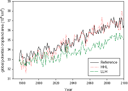
Figure 7. Temporal changes in the area of global potential croplands
over the period of 1977-2100 under the three transient climate change
predictions projected by the MIT 2-D L-O climate model.

Figure 8.Temporal changes in the areas of potential croplands in the
twelve economic regions over the period of 1977-2100 under the three transient
climate change predictions. The acronyms for the economic regions are the same
as given in Figure 4.
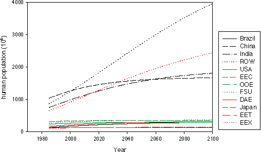
Figure 9. Temporal changes of human population in the twelve economic
regions over the period of 1985-2100. These projections by the Anthropogenic
Emission Prediction and Policy Analysis model (EPPA) are based on the estimates
of United Nations (see reference
[48]).
The acronyms for the economic regionsare the same as in Figure 4.
Geographically, potential croplands expand gradually into high latitudes of
the northern hemisphere over the period of 1977-2100 (Fig. 10, 11, 12). The
northward expansion of potential croplands is the largest in the `HHL' but the
lowest in the `LLH' climate change predictions. Russia and Canada have the
largest increases in potential cropland area, which is mostly attributed to
temperature increases in high latitudes. The MIT 2-D L-O climate projected a
larger temperature increase in high latitudes than in low
latitudes,[12] which is consistent with the results of 3-D GCMs.
[43]
In high latitudes where tundra and boreal forests
dominate, large portions of soils are spodosols and histosols. Physical
properties (e.g., water-saturation in histosols) and chemical properties
(e.g., pH, cation exchange capacity) of these soils may also constrain
distribution of croplands, therefore, large amounts of additional resources and
inputs (e.g., drainage, lime application) are needed to make the soils
suitable for crop cultivation. Kazakhstan, Uzbekistan and Turkmenistan in the
Former Soviet Union economic region have large increases in potential cropland
area. In the southern hemisphere, Brazil and Australia have small increases in
potential cropland area. Cramer and Soloman
[11]
also projected a northward expansion of potential croplands into high latitudes under the
doubled CO2 equilibrium climates projected by the four GCMs (OSU,
GISS, GFDL and UKMO). The MIT 2-D L-O climate model projects less spatial
variation in climate than the 3-D GCMs because it has no variation among the
grid cells along longitudes. A number of 3-D coupled atmospheric-ocean GCMs
have simulated transient climate changes over time,[44] thus it
would be useful to use them to drive the cropland distribution model to examine
the effects of longitude and latitude variations in climate change on potential
croplands. If driven by transient climate change predictions of 3-D GCMs, our
cropland distribution model may give larger spatial and temporal variations in
global potential croplands. However, one limitation of these coupled
atmospheric-ocean GCMs experiments
[44]
to our study here is that
they provide only one transient scenario of CO2 change over time,
and most of them use 1% CO2 increase per year over time.

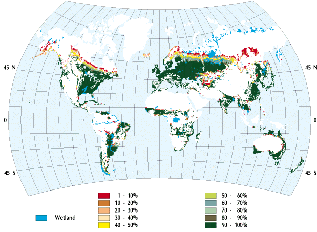
Figure 11. Changes in the spatial distribution of global potential
croplands over the period of 1977-2100 under the HHL transient climate change
prediction. Percentages in the color legend represent the number of years a
grid cell is suitable for cropland over the 124-year simulation in the study.
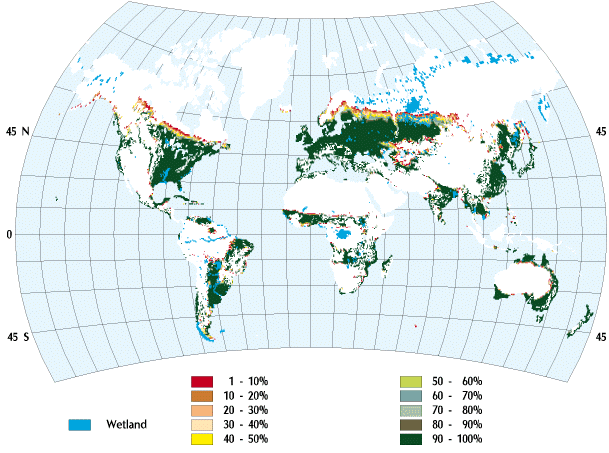
Figure 12. Changes in the spatial distribution of global potential
croplands over the period of 1977-2100 under the LLH transient climate change
prediction. Percentages in the color legend represent the number of years a
grid cell is suitable for cropland over the 124-year simulation in the study.
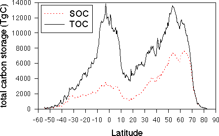
Figure 13. Latitudinal distribution of total carbon storage (TOC) and
reactive soil organic carbon (SOC) for contemporary climate with 315 ppmv
CO2 along 0.5 degree resolution latitudinal bands, as estimated by
the Terrestrial Ecosystem Model (see reference [19]). Total carbon storage
estimated by TEM is the sum of vegetation carbon and reactive soil organic
carbon. Estimates of reactive soil organic carbon in a grid cell exclude inert
soil organic carbon. Vegetation carbon is the difference between total carbon
storage (TOC) and reactive soil organic carbon (SOC).4. Conclusion | Contents |
The cropland distribution model, which is currently based on climate,
soil and topography, represents reasonably well the spatial distribution of
croplands in the world under contemporary climate. This study has shown that
transient climate change can significantly affect the area and spatial
distribution of potential croplands of the world over the period of 1977-2100.
Developed countries account for most of the increase in global potential
croplands, while developing countries have little change in the area of
potential croplands. The modeling in this study has a spatial resolution of
0.5 degrees (longitude) x 0.5 degrees (latitude), which can not account for large
subgrid variations of land cover and land use, especially in mountainous
regions. It will be necessary to conduct similar studies at much finer spatial
resolutions (e.g., 5 minutes longitude by 5 minutes latitude or even 1
km by 1 km) when global data of climate, vegetation, soil and elevation at
finer spatial resolutions are available in the near future.References | Contents |
1. Grubler, A., 1994, Technology, In: Changes in Land Use and Land
Cover: A Global Perspective, W.B. Meyer and B.L. Turner II (eds.),
Cambridge University Press, New York, p. 287-328.
TR-96-6, Department of Geography, University of
California, Santa Barbara, CA 93106.
![]()
--> Home Page | top of page |