WxChallenge Forecast Preparation

Forecasts are due by 8pm (0z)


Email Address: (to keep a copy)
Name:

Time Forecast Prepared (YYMMDD/HHz):
Forecast Period (YYMMDD/HHz): to (YYMMDD/HHz):

Data Collection

Station Weather

Station Observations (opens in a new window)

Category Current Conditions Past Tendencies / Trends
Temperature (F) Max
Min
Dew Point (F)
Pressure (mb) Steady
Rising
Falling
Wind Direction
N
E
S
W
NW
NE
SW
SE
Wind Speed (knots) Steady
Increasing
Decreasing
Cloud Cover
Precipitation


US Weather

Satellite/Surface/Radar(Unisys) (opens in a new window)


Examine the satellite maps. Locate regions of clouds and fronts:


MIT maps loop (opens in a new window)

Examine the US surface and satellite maps over the previous few days. Note movement of the highs and lows, fronts and clouds (satellite)):


Upper Air (opens in a new window)

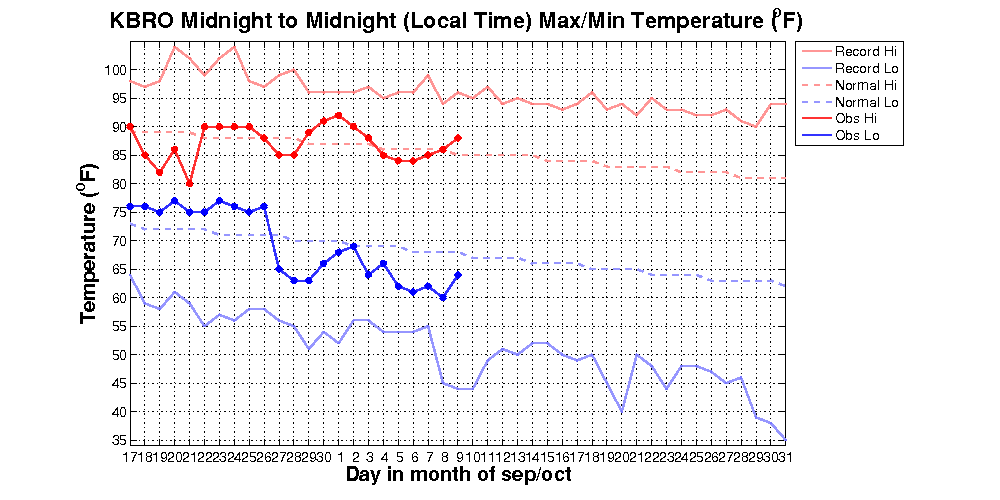
Describe the direction and strength of the upper air flow (the "jet") over the US.


Synoptic Weather Discussion:
Write a brief statement that describes your interpretation of the present synoptic situation. Speculate if there are any significant systems approaching the forecast station area.


CLIMO

Max/min T daily and climo (opens in a new window)
Compare current weather to the climate records.


Forecast Models

Graphical Output

NCEP 'map' view (opens in a new window)

Look at the graphical model outputs of the following models: GFS and ETA (Note: start with the GFS only). Inspect the loop of 850mb Temp, MSLP, 6hr Pcpn.

Model Discussion:
1. Describe what you expect to happen over the forecast area: explain where the models predict the highs and lows to move and check for precip.
2. Briefly describe any major differences between the models (in terms of precip, pressure, etc.) (Advanced)


Model Numerical Output at station location

Time-height cross section (B. Tang) " (opens in a new window): Inspect graphs from (NEAR) SURFACE TIME-SERIES:

Model Run Time 2mTmax 2mTmin MOSTmax MOSTmin
NAM
GFS
Model Run Time windmax(stochastic)(knts)
NAM
GFS
Model Run Time precip (24hrs accumulated) in (in)
NAM
GFS


NWS Forecaster Guidance

Weather Service Forecast


Time
Temp
Precip Prob
Tonight (low)
Tomorrow (high)
Tomorrow night (low)


Your Forecast

The variables you are supposed to forecast are the max, min temperatures, wind max and the precipitation amount in a 24-hour period (06Z - 06Z)

Max T (F):
Min T (F):
Wind max (knts):
Precip (inch):

To submit your forecast go to: WxChallenge Entry page


Your IP address will be recorded.

Back to Synoptic


home | paoc | education | courses | links | search | contact us
Please report suggestions, comments and problems to Scott Stransky.
Copyright © 2005 Massachusetts Institute of Technology