To the critical eye, every technology harbors meaning and purpose unimagined by its initial creators. Human ingenuity can transform a blade of grass into a rope, a basket, or a musical instrument.
What is GIS?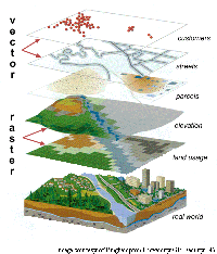
Geographic Information Systems (GIS) is a collection of computer hardware, software, and geographic data used for capturing, managing, analyzing, and displaying all forms of geographically referenced information. GIS is a broad field which provides tools to compare and visualize the spatial relationships between multiple layers of information. For example; the ratio of street trees vs. home forclosures, the number and location of crimes in a political district, or the distribution of Starbucks across Manhattan. Each diverse layer of information is linked to others by virtue of a shared and identifiable existence in the world.
"Geographic Information Systems (GIS) are computerized systems for the storage, retrieval, manipulation, analysis, and display of geographically referenced data. Since they can include physical, biological, cultural, demographic, or economic information, they are valuable tools in the natural, social, medical, and engineering sciences, as well as in business and planning. GIS also is a $2 billion per year high technology industry, and the National Spatial Data Infrastructure (NSDI), base data for GIS, is a key element in the National Information Infrastructure. At the same time, GIS is a young field.
Although its antecedents go back hundreds of years in the fields of cartography and mapping, GIS as such began in the 1960s, and thus many of the individuals involved in the earliest stages of the invention and definition of GIS are alive today. With the maturing of the GIS industry and the development of a "geographic information science" surrounding the technology (Goodchild, 1992), the time is right for a study of the history of GIS based primarily on in-depth interviews with the innovators and founders themselves." - (Mark, Chrisman, Frank, McHaffie, Pickles)
-GIS History Project
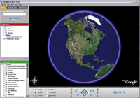
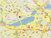
Online spatial applications
Recently, the technology and processes behind contemporary GIS has experienced dramatic, even evolutionary changes. Steadily increasing computing power makes cumbersome software operations almost-universally possible and many types of information can be placed, distributed, or extracted from the far corners of the internet. GIS is no longer a tool reserved for universities, regional governments, and nation-states. It is also no longer specifically about the process of mapping representation or garnering quantifiable results - hence the term "spatial application".
This opens the door for Urban planners use it as a tool for their own designresearch as well as a means to communicate a vision to their constituancies. Scientists can use online maps to organize data and track research developments. Biologists can use them to track the movements of animals. Newlyweds can use GIS to easily print maps to a church their guests have never seen. Real estate developers can use it to find new locations with businesses or infrastructure conducive to new projects.
Nature in GIS
Spatial technologies implicitly document our changing views of nature. Are rivers simply blue lines or do they warrant representation of flood zones, fish populations, or containament levels? If maps had the ability to turn these kinds of details on or off would it matter for the average user? Would homebuyers consider the quality of a nearby stream or simply its existance?
Maps are extremely powerful. What they show has merit and quality. What they omit is unimportant and ill-considered. Just think of the furor over political re-districting maps to understand how easily people, let alone plants and animals can be swept from being a valuable resource to a marginalized community. For an excellent introduction to the power of maps, see John Pickles A History of Spaces: Cartographic Reason, Mapping, and the Geo-Coded World
For more in depth information on GIS, its history, and a variety of current projects, please explore the Links & Resources section.
Otherwise... continue on to the CASES!
(and Spatial Analysis)