Into the House of the Sun - Dayhike on the Halemauu Trail, Haleakala National Park
December 1997
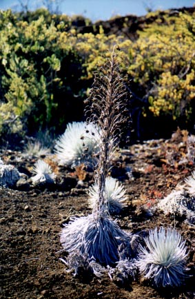
Haleakala is a dormant volcano which forms the eastern part of the island of Maui. Haleakala National Park includes the crater area near the summit and extends down the eastern side of the mountain to the seashore. In all it encompasses everything from the rocky seashore of east Maui up the slopes through rain forest and bogs, subalpine shrubland, into the desert area of the crater floor, and finally the alpine rocky peak of the 10,023 foot summit. In the subalpine shrubland area of the park lives the state bird of Hawaii, the endangered Nene. The nene is believed to have descended from the Canadian Goose and can only be found in Haleakala National Park and in some parts of the Big Island of Hawaii. Also found in the park is the strikingly beautiful silversword (ahinahina). The crater area of Haleakala is the only place in the world where the silversword can be seen. This amazing plant shoots up through the dry volcanic sand in a clump of long thin silvery "leaves". These leaves contain water, much the same way that a cactus stores water. The silversword reaches maturity after about 25 years at which time it flowers once and dies. The daisy like flowers are arranged in an elongated clump along a single vertical stalk, and bloom during the summer months between June and August.
Right: Silverswords in various stages of life: The tall one in the center has already bloomed and is dying. You can see the dead flowers hanging from its long stalk, and its leaves withering. A small young plant is thriving just to the right, as well as just behind it. And further back is a larger plant.
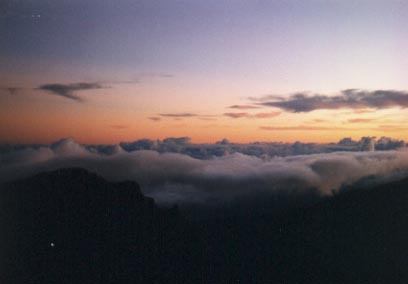
In the dark predawn hours of Christmas Day, I drove the many switchbacks of the Haleakala Highway en route to the summit. Since the temperature drops about 3 Farenheit degrees for every 1000 feet of elevation gained, the summit temperature was probably hovering near freezing as I stepped out of the car. I walked up the set of steps leading to the true summit and the warming hut, and I noticed ice on the sidewalk. From the glass enclosed warming hut I watched as daylight dawned on the peak of Haleakala and the island of Maui. I stood at what seemed like the top of the world, looking down on the clouds and the cinder cones of the crater, as the rising sun painted the rocks and the sand of the mountain bright shades of red and orange. I understood why the Hawaiians named this mountain Haleakala, the "House of the Sun".
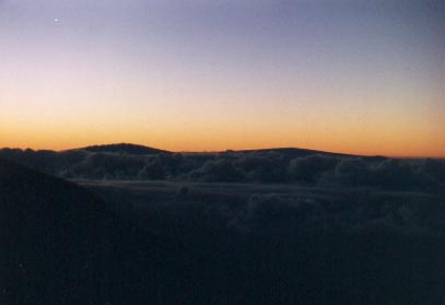
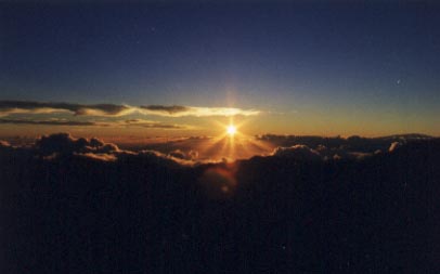
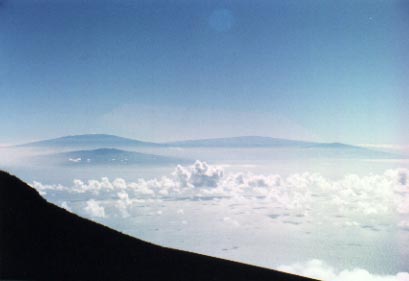
Left The peaks of Mauna Kea (left) and Mauna Loa (right) on the Big Island of Hawaii poke above the clouds. Right The sun finally rises above the clouds, bringing a new day to Maui.
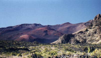
I drove down to the Halemauu Trailhead located at 8000 feet elevation. The trail starts in subalpine shrubland, dotted with bright yellow wildflowers. Three times, I flushed solitary pheasants from the bushes, breaking the complete silence with the flutter of wings, and scaring the heck out of me. After about a mile, I reached the crater ridge and took in an amazing view. About 2000 feet below, and almost straight down as the ridge is very steep, and extending for miles is the valley floor. Directly below is a dry grassland which is a favorite area for the nene. In the distance there are numerous cinder cones, the largest one almost 1000 feet high, painted in many shades of red and brown. I started on my way down the switchbacked trail, descending gradually to the valley floor. The trail is very well maintained, and the walking is fairly easy. After about two miles, I reach the valley floor and enter the grassland. I follow the trail for about a mile, climbing onto a plateau formed from volcanic rock, until I reach the Holua campsite. I encountered two pairs of nene, who were very friendly and curious. I was able to approach them to about 6 feet, and when I walked away and sat down for a rest, they came over to me, making their unusual call which sounds more like a moo of a cow, rather than the honk of a goose. I continued on the trail to the silversword loop, where there are an amazing number of silverswords from seedlings to larger adults to plants that have already flowered and are dying. This volcanic landscape which looks entirely barren from afar is actually full of life!
I retraced my steps back up the switchbacks of the Halemauu Trail to the trailhead parking lot and an end to an exhilarating, although exhausting day of hiking.
Sliding Sands Trail - Haleakala National Park, Maui, Hawaii
December 1999
The weather on the summit of Haleakala was very pleasant - clear skies, temperatures in the 60's, and only a light wind. The panoramic view from the top was amazing. Looking southeast, I could clearly see the peaks of the Big Island of Hawaii. Mauna Kea, the tallest at almost 14,000 feet, was wearing a white snowcap. The fertile isthmus connecting the two lobes of Maui stretched far below us to the northwest. Beyond that were the West Maui mountains, their peaks shrouded by clouds as they so often are.

The Sliding Sands Trail begins just below the summit, 10,000 feet above the bright blue waters of the Pacific Ocean. As the name suggests, the trail is on loose sand which slides with every step. I began my descent to the crater floor, 3000 feet below. As I descended deeper and deeper, I felt as though I had entered another world. Everywhere I looked, there were rocks and cinder cones in many shades of red and brown. It was as if I had left the earth and was on another planet, exploring a foreign landscape. I began to understand why NASA chose this to be one of the training sites for Apollo astronauts in preparation for the lunar landing missions.
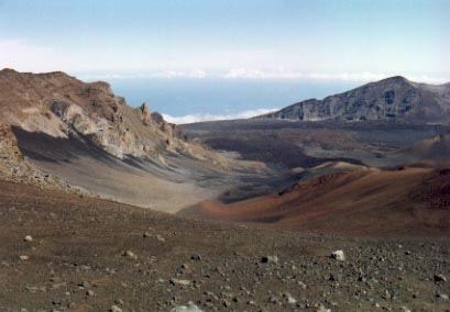
I eventually found myself on the crater floor, looking around at the rock wall rising up thousands of feet all around me. The cinder cones seemed to be even taller, their red and orange slopes shining in the bright sunlight. I wandered the trails, stopping now and again to examine the shiny white silversword plants, in various stages of their lives. As I walked, I noticed how quiet it was. So quiet that it was unnerving. The only sounds were from the crunching of the sand and black volcanic rocks underfoot. When I stopped, I could almost hear myself think.
The time came to make my way back up to the summit, so I began climbing back up the Sliding Sands Trail. The loose sand of the trail, although pleasant for the knees and back on the descent, made the ascent a little more difficult as it caused my foot to slide back slightly with every step. As I neared the top, I looked back down into the crater one last time to admire the surreal landscape before reaching the trailhead.
Kuliouou Ridge Trail, Oahu
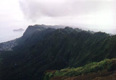
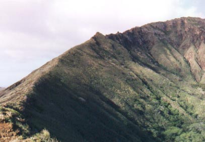
The Kuliouou Ridge Trail climbs to the top of the Koolau Ridge to an elevation of 2025 feet. It is located in the southeastern part of Oahu in the town of Hawaii Kai. The hike starts in a valley between two ridges and climbs fairly steeply via a series of switchbacks. It soon reaches the ridge and you get magnificent views of the ocean and the peaks of Diamond Head near Waikiki and Puu o Kona on the Koolau Ridge. The final push to the top of the ridge is steep and some assistance is given by stairs, but it is still tough. Especially since the recent rains had made the trail muddy. The views from the top are simply marvelous. You can walk up to the edge of the cliff and look straight down as it drops almost vertically down the windward side to the eastern shore of Oahu. The blue waters of the Pacific Ocean stretched out to the horizon broken only by Rabbit Island several hundred yards offshore. Also visible are Koko Crater, Diamond Head, and the town of Hawaii Kai.
The photo shows the ridge with the steep dropoff to the windward side.
Koko Crater, Oahu
Koko Crater is the cone of an extinct volcano located at the eastern tip of Oahu near Hanauma Bay. The trail starts by the stables and the entrance to the botanical garden. The initial climb to gain the ridge of the crater is steep and rocky and I do not recommend it be done when it is wet. Once on the ridge, the trail levels out and is fairly easy for a while. The views continue to get better as you gain more altitude, with vistas of Sandy Beach and Hanauma Bay. Past the halfway point to the peak, the trail becomes more rugged as you need to negotiate a couple of rocky protrusions on the ridge. Sometimes you need to climb over substantial boulders with a very steep dropoff on both sides!
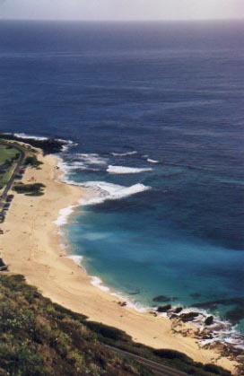
At left is a view of Sandy Beach as seen from the Koko Crater ridge.