July 1997 with Gary, Sherwin, and Taka
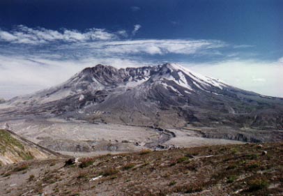
On the morning of May 18, 1980, Mt. St. Helens was hit by an earthquake measuring 5.1 on the Richter scale. The resulting landslide sent a large portion of its north face hurtling down the slope with such great force that it climbed up and over 1300 foot Johnston Ridge. The landslide rapidly released pressurized gases inside the mountain leading to a massive lateral blast that leveled vegetation for 13 miles in a 180 degree arc to the north. Almost simultaneously, a tremendous vertical eruption sent ash thousands of feet into the air and turned day into night. The ash was carried by the prevailing westerly winds and visibly fell in the Great Plains and was even detected in northeastern cities.
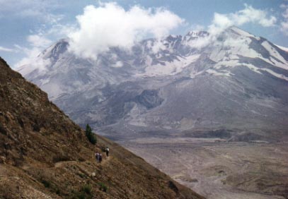 More than seventeen years after that initial eruption, we stood at Johnston Ridge and looked across at Mt. St. Helens. The landscape was surreal. We were surrounded by ash, mud, and pumice. We were standing on what used to be a lush forest. But now, the sun was beating down on us, with no shade in sight. The trees have all been felled by the blast, and now are neatly layed out with their roots pointing toward the mountain. The fallen trees on a nearby ridge reminded me of the quills on the back of a porcupine. However, amidst all of this devastation, there were signs of rebirth. Patches of blue lupine and small green shrubs have started to grow back and add color to the landscape.
We began our hike from the Johnston Ridge Observatory and headed downhill towards the mountain. The trail was on soft, loose ash, and as we walked, our boots began to turn white. We descended down to the base of Johnston Ridge and onto the plain created by the mudflow. Green shrubs and the occasional wildflower dotted the landscape, and in a particularly verdant area, we came across a patch of bright Red Indian Paintbrushes. We looked up at the mountain and the gaping hole which used to be the summit. A lava dome is building there now, steam rising from it like a smoking chimney. I stood there and tried to imagine the mountain as it looked before the eruption. The symmetrical snow capped cone, more than a thousand feet above the current summit, surrounded by a forest of evergreens. Nearby Spirit Lake, boaters and fishermen enjoying the beauty of the crystal clear blue waters. But now, looking around at the uniformly light brown landscape of mud and ash, with the bare shores and waters of Spirit Lake littered with logs, it was difficult to imagine that we were in the same place. It was quite a powerful experience to see firsthand the destructive forces of nature.
September 1999 with Rad, Leslie, Rob, Ed, Nate, and Andy
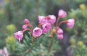
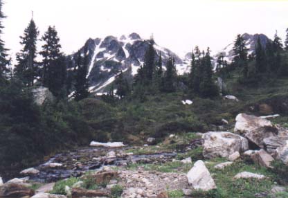
I was invited by my friend Rad to go on a 3 day backpacking trip in the Glacier Peak Wilderness Area, about 2 hours north of Seattle. So with 40 pound packs on our shoulders, we headed off into the wilderness for the 10 mile hike up to our destination, Mica Lake. The day was relatively cool and cloudy - good conditions for a long hike. Our hike was initially flat, with the trail paralleling the Milk River. Eventually, the trail left the river and began to climb steeply along switchbacks to a clearing just below Mica Lake. We briefly considered setting up camp here, as it was a beautiful area with a creek emptying into a small pool fringed by pink mountain heather. However, we decided to climb the last half mile up to the lake. We found a small clearing on a knoll overlooking Mica Lake and set up camp there. I was amazed to see that the lake was still frozen even though it was September. Clearly, it was not going to melt this year. That night, as darkness fell upon us, the skies cleared to reveal a million stars. We lied down on the ground and watched the heavens as satellites ambled slowly amongst the stars and shooting stars streaked across the sky. There is nothing like a night in the wilderness.
The next morning, we awoke to the sound of rain on our tents and a sinking feeling hit us. Opening the tent flap, we saw that we were enveloped in a heavy fog, with no signs of it clearing anytime soon. Eventually, four of us mustered up enough courage to climb out of the tent and go exploring. Our destination was a string of lakes about four miles away. Since visibility was less than a hundred feet, and there were no trails where we were going, we had to rely heavily on map and compass. Ice axes in hand, we set off on the snow in the direction which we thought was correct. 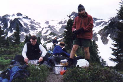 After a couple hundred yards, we came to a pass with several possible options in which to proceed. None of them seemed correct according to the map. We debated for a while, rechecked the map and compass, and debated some more. We did not want to blindly go down a hill for fear of getting stuck and not being able to climb back up the slippery snowy hill. We clearly did not know which way to go. Standing still on an exposed pass in a cold drenching rain with the wind whipping through, I was getting pretty miserable, pretty fast. Just when I was beginning to think that I should go back to camp and get into dry clothes, the fog magically parted and revealed the ridge we were to follow. Although we were disgusted by our lack of map and compass skills, we happily went on our way. We had to descend and traverse some pretty steep snowbanks and I quickly learned how to "ski" down a snowbank on my boots. Traversing across snowbanks also took a bit of getting used to, and I would have felt very uncomfortable if I hadn't had an ice axe. One slip and I could have ended up sliding down several hundred yards. We made it to the lakes with no casualties, although I did slip and fall once and had to use the ice axe to stop a slide. We explored the area for a bit and climbed up to a high point overlooking the lakes. We stopped to rest on the leeward side of the ridge to get out of the wind and throw down some food before heading back to camp. Back in camp, the rain let up enough to allow us to cook under a tarp. Dehydrated camp food never tasted so good.
Following the trend of worsening weather, we awoke on our third day to bitterly cold temperatures and a sagging tent. Not quite sure what was on our tent, we reached up and shook it from the inside, which knocked off the half inch of snow from the rainfly. Rad checked his thermometer. 34 degrees. It was not a difficult decision to pack up our stuff as quickly as possible and get the heck down the mountain. As we descended back down into the valley, the snow turned to rain and eventually stopped. By the time we reached the trailhead, the sun was out and it was downright warm. Although it was somewhat unpleasant at times, trips like these are sometimes the best ones.
September 1999
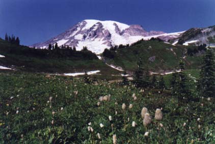
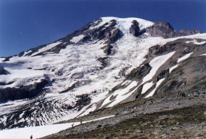
It was a clear mid-September day with not even a trace of a cloud in the deep blue sky. As I started up the trail from the Paradise Inn, I looked up at the Mountain, rising majestically to 14,411 feet above sea level - the second highest peak in the lower 48. There is an extensive network of trails in the Paradise area and the wildflower display during the height of summer is said to be unrivaled. By now they have bloomed and gone, but it is still a beautiful area befitting its name. I hiked up the Skyline trail stopping every now and again to look across at the neighboring volcanoes of the Cascade Range - Mt. St. Helens, Mt. Adams, and Mt. Hood. Two miles into the hike, I reached the foot of the Muir snowfield. I looked up at the line of climbers descending the snowfield, returning from a summit expedition. This is a popular route for summit attempts, with Camp Muir at the top of the snowfield acting as the overnight point. Intrigued, I stepped onto the snowfield and began climbing. I didn't intend on getting all the way to Camp Muir since I didn't leave Paradise until mid-afternoon, and I feared getting caught on the mountain after nightfall. Besides, it was difficult to keep up a good pace because it was so steep and the snow caused my boots to slip back a few inches with every step. However, as I continued to climb, I became intent on getting there. As I met other hikers descending, I asked them how much farther it was to Camp Muir. I got a puzzling array of answers ranging from "it's over two hours away, there's no way you'll make it there and back today", to "it's only an hour or so, just over that rise". Not having gained any useful information, I just kept climbing. I told myself that I would have to turn back at 5pm regardless of whether I had made it to Camp Muir or not. Glancing at my watch occasionally, I gritted my teeth and kept putting one foot in front of the other. My legs started to burn and my lungs cried for oxygen in the thinning air as I approached 10,000 feet above sea level. I had to stop every couple of hundred feet to catch my breath. Five o'clock came and went, but I decided to push on just a bit more and was soon rewarded by the sight of Camp Muir, a collection of huts on a rocky outcrop in the shadow of the icy summit. The camp was bustling with climbers who would make an attempt on the summit the next morning. I sat down and took in the view of the surrounding hills, reveling in my accomplishment. Although the climb from Paradise to Camp Muir is not very long, it is extremely steep as it climbs 4600 vertical feet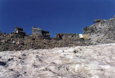 in just five miles. The descent was considerably easier as I alternately "boot skied" and walked down. There were even some sections where there were tracks left by previous hikers who had slid down on their butts. I, of course, took advantage and enjoyed the ride down. As I approached Paradise, the sun set over the Cascade Range, and the sky was lit up in a bright orange fire. The alpenglow on Mt. Adams made the rocky volcano glow in many soft shades of pink and orange. Blacktail deer were out foraging on the grass, ignoring me as I ambled past. This truly was paradise.
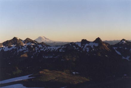
Alpenglow on Mt. Adams.