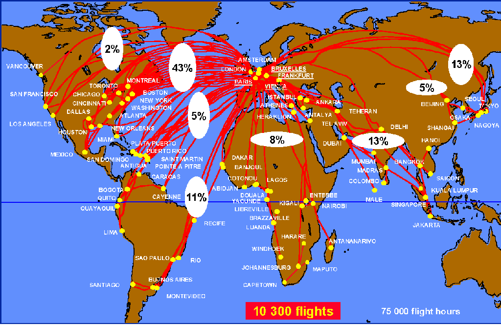
Figure 1. Coverage map of MOZAIC flights. Schematic flight routes are shown as red lines. The percentages of flights to and from the various global sectors are also displayed.
The number of flights has been steadily growing, and the long-term outlook for continued "funding" looks excellent given the penchant for humans to travel around the world. And yet, to date, there have been few attempts to tap this resource for atmospheric chemistry studies. One study, however, has chalked up 40 million miles over the past five years.
Using commercial airliners to measure trace gases in the atmosphere is a well-justified self-monitoring activity, since engine exhaust is constantly injecting material into the flight corridors. Although the total amount is not great (2 to 3% of all anthropogenic atmospheric pollution), the UT/LS region is sensitive to aircraft emission in several ways. Nitrogen oxides, CO, and hydrocarbons through photochemical reactions may increase the amount of tropospheric ozone, which is a greenhouse gas; and water vapor, soot, and sulfur oxides can increase contrail clouds and aerosols that may modify UT/LS radiative forcing and the global temperature.
With air traffic expected to double in the next 10 to 15 years, aviation effects on the atmosphere can only be expected to increase as well. To take advantage of this existing atmospheric sampling infrastructure, a program to measure ozone and water vapor by Airbus in-service aircraft (MOZAIC) was launched in January 1993 [Marenco et al., 1998]. So far MOZAIC has recorded over 10,300 flights totaling 74,000 hours and 40 million miles. Initial scientific results were published in a special section of the Journal of Geophysical Research in 1998 (vol. 103, no. D19) as well as in other journals, including two papers in Nature.
Also, under the tropospheric ozone (TROZ) campaign, the meridional distribution of ozone was studied using 37 commercial flights between northern Europe and South Africa during 1970-1974. That study concluded that upper tropospheric ozone distribution was determined primarily by input from the stratosphere [Fabian and Pruchniewicz, 1977].
NASA's global atmospheric sampling program (GASP) was the first continuous, long-term effort to piggyback trace gas measuring instruments on commercial jetliners. Four B-747s (two Pan American, one United, and one Qantas) were equipped with instruments to routinely measure ozone, carbon monoxide, water vapor, aerosols, temperature, and horizontal winds [see, e.g., Nastrom, 1979].
The program lasted from 1975 to 1979 with over 6900 flights (80% between 30 deg N and 55 deg N) recorded. Highlights included estimates of the vertical and horizontal flux of ozone near the tropopause, interhemispheric transport deduced from CO results, the discovery of upper tropospheric low-ozone regions caused by Walker circulation transport from the western Pacific boundary layer, the refutation of the mesoscale kinetic energy gap, and demonstration of terrain effects on flight-level mesoscale wind variability.
Now, after nearly 2 decades, commercial airliners are again being used for collecting trace gas data. Carbon monoxide, carbon dioxide, and methane were measured routinely between April 1993 and July 1996 on a Japan Airlines B-747 flying between Japan and Australia [Matsueda et al., 1998]. Twelve air samples were taken during each flight and analyzed later in a laboratory. Results showed that the seasonal cycles of these trace gases differ significantly between the Northern and Southern Hemispheres and that southern African or South American biomass burning signatures appear in the upper troposphere over Australia in the spring.
Another study, the nitrogen oxides and ozone measurements along air routes (NOXAR) investigation, was conducted from May 1995 to May 1996. Instruments were operated on 540 Swissair B-747 flights in the Northern Hemisphere, with data recorded every 3 s for a horizontal resolution of about 750 m at cruise altitude. One of the initial major findings of NOXAR was the detection of large-scale (100-1300 km) nitrogen oxide plumes in the upper troposphere that were produced by continental pollution or lightning [Brunner et al., 1998]. The elevated levels of ozone within the plumes, particularly in the summer, suggested an enhancement in photochemical ozone production because of the high nitrogen oxide concentration.
Although GASP generated a formidable amount of data on the UT/LS region, data quality and resolution issues hindered their full use for scientific purposes, especially for the trace gases. For most flights the data were collected only at 5-min intervals, there were instrumental problems with the CO instrument due to water condensation, and there were uncertainties about the water vapor data quality. Moreover, these experiments were performed during a time when theories on photochemical formation of ozone were just developing and their significance was not yet universally recognized.
MOZAIC's modus operandi was to keep the instrument package small and light to minimize the cost load for the carriers. For the first phase, ozone, water vapor, and temperature probes were integrated into a rack that was roughly equivalent to the space and weight of one passenger plus baggage (full weight 117 kg). The package was installed in the avionic compartment below the cockpit, with the intake tubes mounted on the fuselage 7 m back from the aircraft's nose. The system operates automatically without help from the flight crew. However, the airline maintenance crew does check for malfunctions during routine stopovers. Time, position, pressure, airplane speed, and horizontal wind data are obtained from the aircraft's air data computer. All the data are recorded at 4-s intervals from takeoff to landing.
The processed and validated data are stored in a database at Centre National de Recherche Météorologique, Toulouse, operated by Météo-France. To aid in data interpretation, daily maps of meteorological and satellite data are also archived. Potential vorticity and tropopause characteristics interpolated every minute along each aircraft trajectory also are available. Booklets containing data plots from each flight and daily meteorological fields are available free of charge to MOZAIC coinvestigators (see end of article on how to become a coinvestigator).
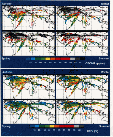
This climatology is important for understanding dynamic and chemical processes involved in the upper tropospheric ozone distribution, for 3D model validations (only MOZAIC data are available at these altitudes with such wide spatial coverage), for comparisons with other ozone measurements (ozone soundings, other airborne programs, satellite data), and for estimation of flight times within the stratosphere. The horizontal wind and temperature fluctuation data can also be used to study gravity waves and 2D turbulence and the atmospheric kinetic energy spectrum in general.
The comparison between the 2-year MOZAIC ozone climatology (1994-1996) and the long series of some stations from the ozone sounding network has shown that they were in rather good agreement, despite the different natures of the programs. Mean concentrations derived from ozonesonde series are about 3 to 13% higher that those obtained by MOZAIC in the free troposphere; these differences are within the range of uncertainties of the two techniques.
Recent modeling studies have demonstrated that aircraft contrails have the potential for climate forcing. However, a quantitative assessment has been difficult because contrail parameterization has been problematic. The MOZAIC humidity and temperature fluctuation data have helped in this regard. The fluctuation distributions together with local criteria for the formation and persistence of contrails have allowed calculation of the maximum fractional coverage of contrails within a model grid [Gierens et al., 1997].
The study also showed that large-scale distributions of relative humidity and temperature fluctuations could not be modeled as Gaussians. Instead, they manifested long tails that were closer to Lorentzian in form.
Ozone measurements during cross-equatorial MOZAIC flights have confirmed the dynamical barrier effect of the subtropical tropopause to exchanges between the subtropical stratosphere and the tropical troposphere. However, it seems that the barrier could be leaky at small scales (<100 km) as ozone transients are observed south of the subtropical jet in the upper equatorial troposphere [Suhre et al., 1997].
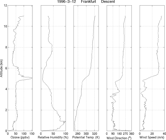
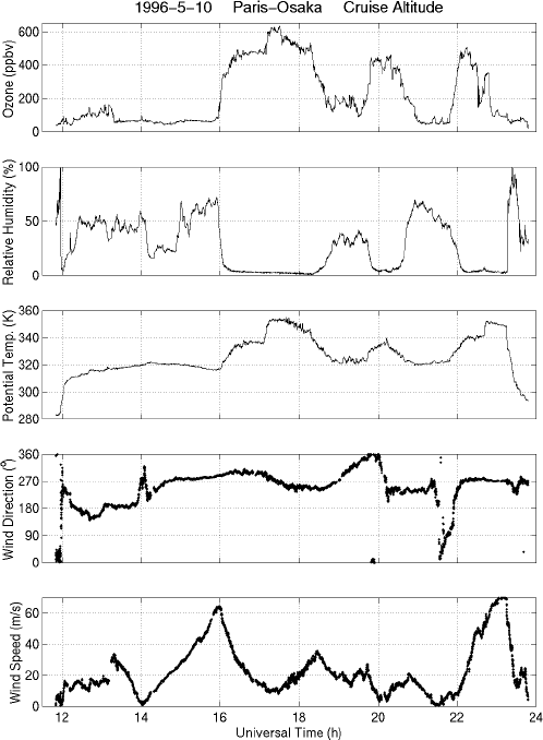
The high quality and fine time resolution of the MOZAIC ozone data allow the study of small-scale features. For example, an important characteristic of the layers is that they are sometimes as thin as a few hundred meters. Chemical reaction rates can be highly nonlinear, so the output of an averaged input quantity is not necessarily equal to the averaged output of multiple inputs at finer resolution. Such resolution dependency has shown up quite strongly in model calculations of chemical ozone loss. Current models are unable to resolve these thin layers, which places a fundamental limit on their accuracy. Thin humidity layers can also have local radiative forcing effects. Dry layers are self-stabilizing; wet layers are destabilizing. Patches of clear-air turbulence may be generated by such unstable layers.
These new measurements will considerably enhance the possibilities of interpretations in the UT/LS. Possible will be evaluation of convective transport of pollutants from the continental boundary layer into the upper troposphere; climatology of nitrogen species; discrimination between stratospheric and tropospheric air (combined with ozone, water vapor, and potential vorticity criteria); better identification of tropospheric layer characteristics based on criteria similar to those used for PEM data; better validation of 3D chemical and transport models; and large-scale distributions of aerosols and turbulent structure of the atmosphere. The extension of ozone and water vapor time series also will offer the possibility to study trends and interannual variabilities in the UT/LS.
Besides meeting its own programmatic scientific goals, it is MOZAIC's philosophy to maximize the scientific use of its database. A huge reservoir of high quality observations, the database is indeed of valuable interest for the international scientific community. Powerful tools have been developed to allow easy access and fast recovery of the data by authorized users via ftp and the Web.
Interested scientists are encouraged to become coinvestigators in the program by developing collaborations with MOZAIC participants under rather flexible conditions -- submission of a scientific project and signing of the MOZAIC Data Protocol. Information on the program and on the procedure to follow are available on the Web (http://www.aero.obs-mip.fr/mozaic/) and from Alain Marenco, Laboratoire d'Aérologie, Observatoire Midi-Pyrénées, 14 Avenue Edouard Belin, 31400 Toulouse, France; E-mail: mara@aero.obs-mip.fr.
Fabian, P., and P. G. Pruchniewicz, Meridional distribution of ozone in the troposphere and its seasonal variations, J. Geophys. Res., 82, 2063-2073, 1977.
Gierens, K. M., U. Schumann, H. G. J. Smit, M. Helten, and G. Zängl, Determination of humidity and temperature fluctuations based on MOZAIC data and parametrization of persistent contrail coverage for general circulation models, Ann. Geophys., 15, 1057-1066, 1997.
Marenco, A., et al., Measurement of ozone and water vapor by Airbus in-service aircraft: The MOZAIC airborne program, An overview, J. Geophys. Res., 103, 25,631-25,642, 1998.
Matsueda, H., H. Y. Inoue, Y. Sawa, Y. Tsutsumi, and M. Ishii, Carbon monoxide in the upper troposphere over the western Pacific between 1993 and 1996, J. Geophys. Res., 103, 19,093-19,110, 1998.
Nastrom, G. D., Ozone in the upper troposphere from GASP measurements, J. Geophys. Res., 84, 3683-3688, 1979.
Newell, R. E., V. Thouret, J. Y. N. Cho, P. Stoller, A. Marenco, and H. G. Smit, Ubiquity of quasi-horizontal layers in the troposphere, Nature, 398, 316-319, 1999.
Seiler, W., and C. Junge, Carbon monoxide in the atmosphere, J. Geophys. Res., 75, 2217-2226, 1970.
Suhre, K., J.-P. Cammas, P. Nédélec, R. Rosset, A. Marenco, and H. G. J. Smit, Ozone-rich transients in the upper equatorial Atlantic troposphere, Nature, 388, 661-663, 1997.
Thouret, V., A. Marenco, P. Nédélec, and C. Grouhel, Ozone climatologies at 9-12 km altitude as seen by the MOZAIC airborne program between September 1994 and August 1996, J. Geophys. Res., 103, 25,653-25,679, 1998.
Copyright 1999, American Geophysical Union
Originally published in Eos Trans. AGU, 80, 377-384, 1999.
Back to my publications list.
Back to my home page.
Last modified: Wed Oct 13 17:56:05 EDT 1999