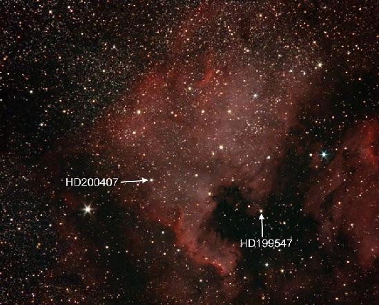
The image is of a well-known nebula called the North America Nebula,
thanks to the strong resemblance between the nebula shape and the shape of
the North American continent. Whether or not the solver sees this
resemblance, they should be able to learn the nebula’s name through any of
the following:
- a Google image search
-
checking on “NGC 7000” in the flavor text (this is the commonly used
catalogue number for the nebula) with Google or a star chart
-
the information labeled “Vegas and Orlando.” This small table below the
image shows the catalog numbers for two stars which are positioned in
the Nebula, information which can be gleaned from a Google search or
star chart software. It may take someone with no astronomy background a
bit of reading to ascertain that the numbers flanking the star catalog
numbers are celestial coordinates for these stars, the Right Ascension
(RA) and Declination (Dec), which play the same roles on a star chart as
longitude and latitude on a terrestrial map.
While a solver familiar with astronomy and planetarium software may sort
this out quicker, the pivotal “aha” can be found in the top Google hits
for HD200407. The Simbad database shows the coordinates and has a small
image of the star in an interactive “AladinLite view.” Clicking on this
and zooming out will reveal the same thing that could be found in
planetarium/star chart software – this star is found within the NA Nebula,
and in fact is in a position that could correspond to Las Vegas if the
Nebula were indeed a map of North America. Similar information can be
found for the second star HD199547 and the solver will see that this is in
the nebula region which approximates the Florida peninsula. The two
labeled stars are indicated below for reference.
The solver will need to grasp that the table showing 12 sets of
coordinates, which also lie in space within the nebula, are meant to
indicate a series of cities on the North American continent. The
alternating blue and pink colors will be related in some way to the text
which says:
My World in blue
Stars Dance in pink
Note that the coincidental resemblance between the nebula and the
continent means that there is no “correct” or “perfect” alignment of the
two. The solver might want to go through the exercise of lining up the
nebula image with a map. This step is not necessary, but it may help them
get a good handle on the transformation they will need to do with the set
of celestial coordinates to find specific locations in North America. If
they’re skilled with Photoshop and make some good choices on maps, they
may be able to solve the puzzle graphically by plotting the 12 sets of
coordinates on the nebula image and then seeing how these points overlay
with a map. There are a number of ways that this can go wrong, however, so
solvers will almost certainly need to do an arithmetic transformation of
the celestial RA and Dec into longitude and latitude to find the North
American cities which are clued in the colored table. Either way, they
will need to use the relationships between the two alignment stars and Las
Vegas and Orlando.
The calculations used to set up the puzzle use the coordinates provided by
a google search for Las Vegas and Orlando and are very likely to be the
obvious starting point for solvers. These are:
| Las Vegas | 36.1699412 | -115.1398296 |
| Orlando | 28.5383312 | -81.3792396 |
The solver will also need to make the “aha” connection to Justin Bieber’s
2010 My World Tour, and his one-time girlfriend Selena Gomez’s 2013 Stars
Dance Tour. Google search of the phrases “My World” and “Stars Dance”
should turn up links to these tours, as they were the debut tours for each
artist and were named after their debut solo albums. The puzzle title
“Star Tours” should lead solvers to the tour information (rather than the
albums); the Wikipedia entry for each tour includes the full sequence of
cities and dates. The solver will need to look up the date from the
appropriate tour in each of the clued cities to complete the grid labeled
“Star Date” (“Star Date” has no real meaning but here refers to the month
and date, e.g., 11/19). The puzzle cannot be solved without these dates.
To identify the cities, the solver will convert RA to Longitude and Dec to
Latitude using the fixed ratios between Orlando and Las Vegas. In excel or
Google Sheets they will do the following steps or similar:
-
Coordinates are best manipulated when in digital format, so they will
need to convert RA and Dec to digital from Hours, Minutes, Seconds and
Degrees, Minutes and Seconds using formulas along these lines:
- RA (digital) = (Hours)+(Minutes/60)+(Seconds/3600)
- Dec (digital) = (Degrees)+(Minutes/60)+(Seconds/3600)
-
Calculate these ratios:
- ∆ for RA between the stars ⁄ ∆ for Longitude between the cities
- ∆ for Dec between the stars ⁄ ∆ for Latitude between the cities
-
Use the ratios to add the right ∆’s for Longitude and Latitude to the
actual coordinates for Vegas (or Orlando depending on how you set up the
arithmetic).
-
This will generate a series of terrestrial coordinates for cities in
digital form.
-
The complete data table showing digital terrestrial coordinates and
corresponding cities is shown below. Note that the cities can be
efficiently identified by importing the latitude and longitude columns
into Google’s My Maps. Simply pasting each set into Google Search one at
a time will also work. The tour dates are also shown here and would be
found from the Wikipedia data table for each of the two tours, but only
after identifying the cities. Note that the tour lists also enable
solvers to confirm cities like Broomfield (near Denver) for the answer
grid.
| Celestial RA |
Celestial Dec |
RA |
Dec |
Lat |
Long |
City |
Tour Date |
| 20 | 58 | 59 | 44 | 9 | 38 | 20.9830555556 | 44.1605555556 | 35.4667375628 | -97.5256087304 | Oklahoma City | 11/03/10 |
| 21 | 1 | 25 | 44 | 41 | 40 | 21.0236111111 | 44.6944444444 | 49.6936574658 | -112.8332054385 | Lethbridge | 08/16/13 |
| 20 | 55 | 19 | 44 | 18 | 25 | 20.9219444444 | 44.3069444444 | 39.3676672136 | -74.4593671155 | Atlantic City | 11/20/10 |
| 20 | 55 | 14 | 44 | 21 | 27 | 20.9205555556 | 44.3575 | 40.7148573397 | -73.9351343516 | New York City | 10/16/13 |
| 20 | 59 | 8.2 | 43 | 56 | 2 | 20.9856111111 | 43.9338888889 | 29.426588426 | -98.4901970161 | San Antonio | 11/05/10 |
| 20 | 58 | 55 | 44 | 42 | 8 | 20.9819444444 | 44.7022222222 | 49.9009174852 | -97.1062225193 | Winnipeg | 08/19/13 |
| 21 | 0 | 11 | 44 | 19 | 40 | 21.0030555556 | 44.3277777778 | 39.9228279798 | -105.0745605317 | Broomfield | 07/08/10 |
| 20 | 57 | 11 | 44 | 19 | 19 | 20.9530555556 | 44.3219444444 | 39.7673829653 | -86.2021810286 | Indianapolis | 11/19/13 |
| 20 | 58 | 6.5 | 43 | 57 | 50 | 20.9684722222 | 43.9638888889 | 30.2260199294 | -92.0211647087 | LaFayette | 08/01/10 |
| 20 | 56 | 54 | 44 | 5 | 46 | 20.9483333333 | 44.0961111111 | 33.7494402592 | -84.4197896311 | Atlanta | 10/26/13 |
| 20 | 59 | 26 | 43 | 47 | 37 | 20.9905555556 | 43.7936111111 | 25.6885059333 | -100.3564656559 | Monterrey | 09/30/11 |
| 21 | 1 | 18 | 44 | 5 | 5 | 21.0216666667 | 44.0847222222 | 33.4459523736 | -112.0992795689 | Phoenix | 11/05/13 |
Complete the two indicated grids:
| | | O | K | L | A | H | O | M | A | C | I | T | Y | | | | | | | 1 | 1 | 0 | 3 |
| | | | | L | E | T | H | B | R | I | D | G | E | | | | | | | 0 | 8 | 1 | 6 |
| | | | | | A | T | L | A | N | T | I | C | C | I | T | Y | | | | 1 | 1 | 2 | 0 |
| | | | | | | | N | E | W | Y | O | R | K | C | I | T | Y | | | 1 | 0 | 1 | 6 |
| | | | | | | | S | A | N | A | N | T | O | N | I | O | | | | 1 | 1 | 0 | 5 |
| | | | | | | | W | I | N | N | I | P | E | G | | | | | | 0 | 8 | 1 | 9 |
| | B | R | O | O | M | F | I | E | L | D | | | | | | | | | | 0 | 7 | 0 | 8 |
| I | N | D | I | A | N | A | P | O | L | I | S | | | | | | | | | | 1 | 1 | 1 | 9 |
| | | | | L | A | F | A | Y | E | T | T | E | | | | | | | | 0 | 8 | 0 | 1 |
| | | | | | | | A | T | L | A | N | T | A | | | | | | | 1 | 0 | 2 | 6 |
| | | | | | | | M | O | N | T | E | R | R | E | Y | | | | | 0 | 9 | 3 | 0 |
| | | | | | | | P | H | O | E | N | I | X | | | | | | | 1 | 1 | 0 | 5 |
The last step of the extraction requires using the 12 digits of the answer
as coordinates in degrees, minutes and seconds format (just as the
original celestial coordinates are in minute and second format). “City and
State” is a clear indication that we are looking for a location in the
US. Placing any of the following into Google will bring a pointer to a
location in Tennessee:
- 36 06 59 -89 16 05
- 36 06 59N 89 16 05W
- 36°06’59” -89°16’05”
- 36°06’59”N 89°16’05”W
Zooming in will show that the City and State are NEWBERN TENNESSEE.