Massachusetts Institute of Technology • Program in Science, Technology and Society
Science, Technology and Global Security Working Group
Home
People
Research
Workshops
Contact Us
Analyzing the Capabilities and Development of Foreign Space Programs
Principal Researchers: Geoff Forden, Ted Postol, Subrata Ghoshroy
As a group, we have a common interest in the development of space programs in different countries. While our different research interests have taken us in different directions, we have, as a group, developed contacts in the space agencies in Europe, Russia, China, and India. Some of our research topics are listed below.
Iran’s
Space Launcher Development Program

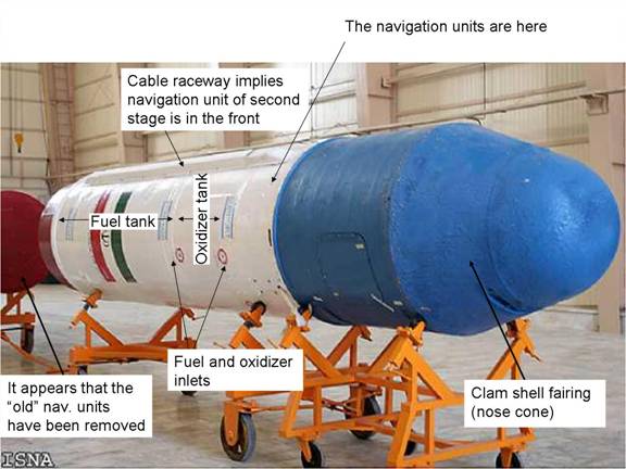
Iran has in recent years announced that it is developing a capability to put a satellite into orbit. This of course has created considerable concern in Western capitals that this same technology could be used to launch nuclear warheads. (See our discussion of how to solve the Iranian nuclear crisis here.) The launch of a Safir rocket on 17 August 2008, together with photographs of Iranian President Ahmadinejad’s visit to the Iranian Space Center, allows us to evaluate the technological path Iran is following in this development program. It is clear that Iran has jumped off the path of enlarging or “improving” SCUD technology. In particular, there are a number of important innovations Iran has made:
1) using cluster of engines for second stage using a SINGLE TURBOPUMP—both are significant advances in technology all by themselves. The static test version shows two engines but it makes more sense for them to use 4 during the actual flight. It also looks like the turbopump can be used to facilitate staging by providing a small amount of acceleration during the second stage ignition.
2) looks like it uses gimbaled engines (see hydraulic jack) for thrust vector control—another significant advance in technology, and the thing that probably failed during the test flight.
3) uses “new” engines (not SCUD or SA-2)—speculation: why develop a new engine for SCUD fuel? It makes more sense to develop engines for a more powerful fuel such as UDMH.
A preliminary analysis of the two stage Safir rocket can be found here: Safir—Iran Jumps Off the SCUD Bandwagon.
Analysis of the Chinese Anti-Satellite Weapon Test
Geoff Forden

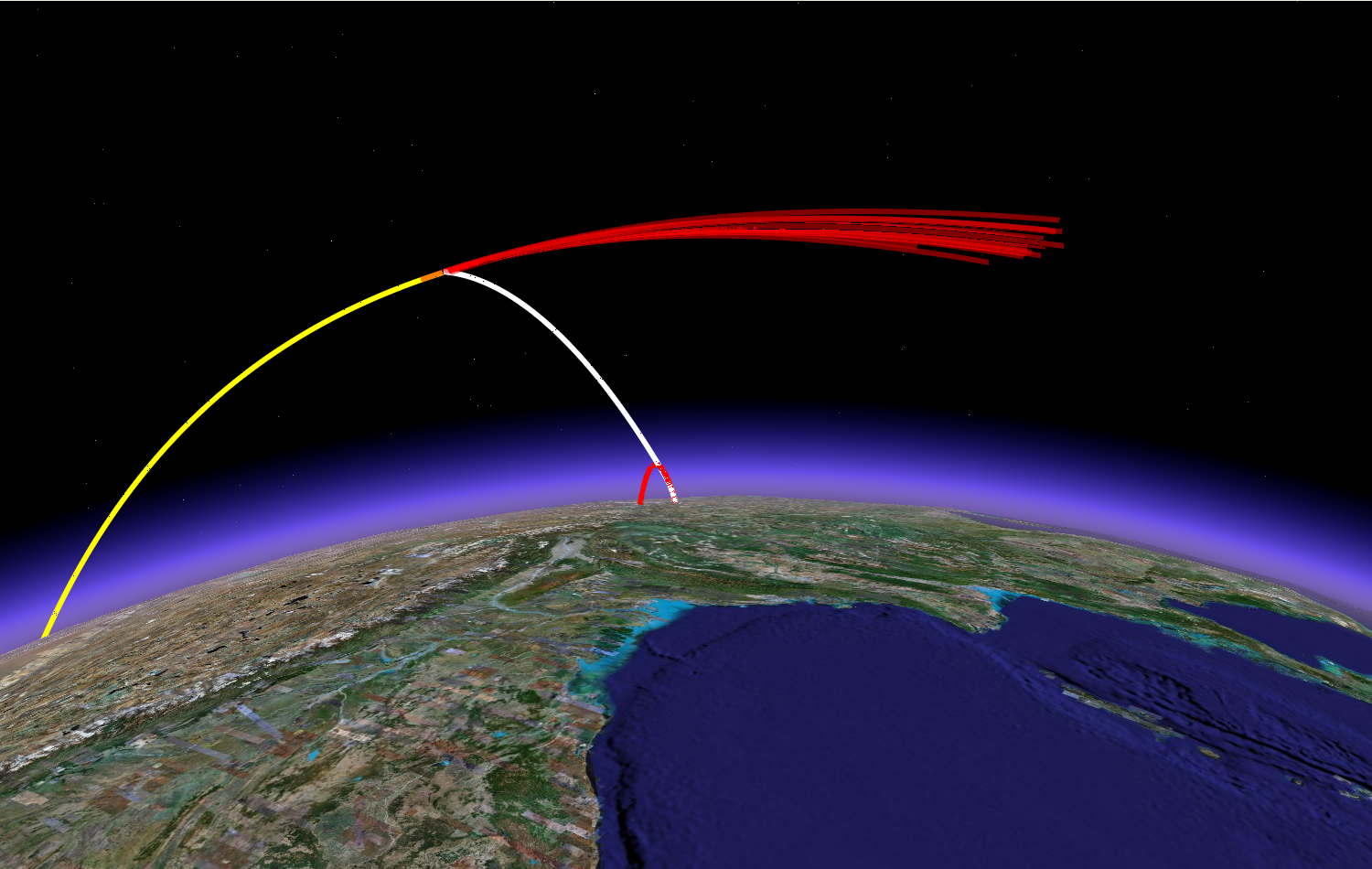
At 22:26 GMT, 11 January 2007, China slammed a kill vehicle into one
of its dead metrological satellites, proving to the world that they were
part of the small but unfortunately growing club of countries that can
accomplish the difficult task of hypervelocity interceptions in space. As
a signal to the world, this test highlighted both China’s technological
prowess and the fact that China will not quietly stand by while the United
States tries to expand its influence in the region with new measures
such as the US-India nuclear deal. We have analyzed the orbits
of the debris from this interception and from that put limits on the
properties of the interceptor. We find that not only can China
threaten low Earth orbit satellites, but, by mounting the same interceptor
on one of its rockets capable of lofting a satellite into geostationary
orbit, all of the US communications satellites.
Click here to download a copy of a technical analysis of the recent test.
Click here to link to Google Earth Chinese ASAT test.
Click here to listen to Geoff Forden on CBC's "The Current" discuss the Chinese ASAT test
China's ASAT: No Space Age Perl Harbor
Geoff Forden
China's nascent space
weapons capability presents a challenge to the US dominance of space. But how should we respond? Should we develop
space defenses? Or should we try to diplomatically limit the development
of these weapons? These question are addressed in an analysis by
Geoffrey Forden posted on Wired’s defense blog, DANGER ROOM on
the one year anniversary of China’s ASAT test.
Part 1
Part 2
Part 3
Strategic Capabilities and Implications of China’s Navigation Satellites
Geoff Forden

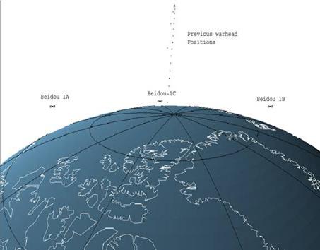
CAPTION A warhead, launched from China and on route to Washington, D.C.,
remains in contact with all three Chinese navigation satellites (Beidou
1A, Beidou 1B, and Beidou 1C) for most of its trajectory. This
image shows the view looking back from the warhead
ABSTRACT
On the 27th of October, 2005, the first Iranian satellite (the Sinah-1,
in a sun-synchronous orbit with an altitude of approximately 700 km)
was launched aboard a Russian rocket. Clearly, more and more countries
are attempting to join the Space-faring club. Our group uses publicly
available information (such as the satellite’s orbital parameters)
to estimate the technical capabilities of these foreign satellites and
from that infer their security implications. Previous studies have
resulted in an understanding of the strategic implications of China’s
indigenous navigation satellites and estimates for the current state
of Russia’s space-based early-warning satellites.
With the launch of the Bei Dou 1C satellite on 24 May 2003, China claims
to have completed its constellation of three navigational satellites. This
system is very different from the US navigation satellite system (GPS/NAVSTAR),
the Russian GLONAS constellation and the planned European Galileo system.
With only three satellites, and in geostationary orbit, the Chinese system
can only be used on a regional basis as opposed to the global functionality
of the others. Furthermore, assuming it uses the same operational principles
as the other navigational systems - inferring the position of an operator
by measuring the distance from a set of satellites - it appears to have
only limited utility for navigation of terrestrial users.
Since 1995, the constellation of Russian early-warning satellites has
deteriorated significantly. Russia had a full complement of those satellites
during the 1995 Norwegian rocket incident. Since then, Russia has not
replaced satellites often enough to maintain complete 24-hour coverage.
In fact, assuming every satellite—even those that have drifted
far from their optimal orbits—is still working, Russian coverage
has dropped to less than 17 hours per day. In reality, the coverage is
probably considerably less. After all, Russia, and the Soviet Union before
it, went to considerable effort to almost daily realign their early-warning
satellites into a very precise formation to maintain the best surveillance
of U.S. nuclear forces. Today, the satellites have been allowed to drift
far from those optimal orbits, presumably because they no longer function.
Orbital Debris: Drafting, Negotiating, Implementing a Convention
Thierry Senechal
It is time to recognize that while space may be infinite, Earth orbital space is a finite natural resource that must be managed properly. The problem we face with space pollution is complex and serious. The space treaties and conventions are not sufficient. They were drafted at the time of space exploration in the 1960s and 1970s. Today, they fail to account for rapid changes in the field, especially the increasing commercial activity. Moreover, the existing mitigation guidelines remain voluntary and are not legally binding under international law. As a result, space debris tends to accumulate and remains in orbit for a long period of time.
A space debris convention is thus warranted. The proposed international
convention would have the following objectives: 1) Implement an international
and independent tracking and cataloguing system for space debris; 2)
Adopt enforceable space debris mitigation and disposal guidelines; 3)
Enforce a space preservation provision for protecting the most vulnerable
outer space regions and; 4) Define a space debris compensation and dispute
settlement mechanism. The convention must bring all together policy-makers
and the civil society for addressing this problem; it is also time for
the space industry to play its corporate social responsibility and to
actively seek to participate to the drafting and implementing of the
convention.
More than ever, the space debris problem is hindering space commerce, space tourism, the scientific exploration of space, the use of raw materials from space, and even distant plans for the future settlement of space. The possibility of great harm posed by debris should bring all nations and stakeholders together to find the most appropriate solutions.
Publications
The Military
Capabilities and Implications of China’s Indigenous
Satellite-based Navigation System, Geoff Forden, Science and Global Security,
Vol. 12, no. 3, 2004, pp. 219-250.
China’s Satellite-Based Navigation System: Implications for Conventional
and Strategic Forces, Geoff Forden, Breakthroughs, Vol. XIII, no. 1,
Spring 2004, pp. 8-13.
Strategic Uses for China’s Bei Dou Satellite System, Geoff Forden,
Jane’s Intelligence Review, October 2003, pp. 26-31.
Russia’s Early Warning System: Which Came First, Technology or
Doctrine?, Geoff Forden, Breakthroughs, Vol. X, no. 1, Spring 2001, pp.
9-16.
Reducing a Common Danger:
Improving Russia’s Early-Warning System,
Geoff Forden, CATO Policy Analysis Paper # 399, 3 May 2001
Presentations
Strategic Implications of China’s Space-Based Navigation System,
Geoff Forden, Technical Working Group Seminar Series, MIT, 25 September
2003
See our work on anti-satellite weapons here.
![]() Massachusetts
Institute of Technology • Science, Technology and Global Security
Working Group
Massachusetts
Institute of Technology • Science, Technology and Global Security
Working Group
Building
E51-163 •70
Memorial Drive • Cambridge, MA 02142
Copyright © 2009
Last modified: 30 April 2009