Massachusetts
Avenue and Main Street
|
The row of city blocks just north of Main Street and just east of Massachusetts
Avenue in Cambridge, Massachusetts, defines two communities –
one distinctly urban, the other almost suburban. Their struggle to coexist
has obviously been uneasy, and if the occasional deserted lot or boarded
window is any indicated, not particularly successful. But why would
a neighborhood try to separate itself so completely from its adjacent
industrial and commercial blocks, especially when the result may be
hurting both? The answer lies in the originally suburban development
of the site. This dichotomy, representative from the beginning of the
difficult struggle between individuals’ homes and their workplaces,
is the result of America’s suburbanization. Since the nineteenth
century, the neighborhood formed by this intersection has survived the
onslaught of commuter transportation and industry while struggling to
maintain its sense of community. The result is a fairly static site
that, once built-out, managed to maintain its two established, albeit
conflicting, identities.
The original development of this community on the outskirts of Cambridge
Port coincided with American suburbanization in the nineteenth century.
In general, the attraction of the suburbs was their “easy access,
pleasant surroundings, cheap land, or low taxes” (Jackson p. 29).
Cambridge Port, however, was on the other side of the Charles River
from Boston and was only easily accessible from what is now Harvard
Square. Unlike much of present-day Boston, what would become the intersection
of Main Street and Massachusetts Avenue was not underwater but situated
on the bank of Little Cove (Boston, and its Environs). Although
the name “Little Cove” sounds pleasant, the area was probably
swampy and anything but. This leaves few plausible reasons for the development
of this particular site, namely, cost and necessity. The land on this
side of the Charles River was indubitably less expensive to purchase
and maintain than property in the city. In the same way -- short of
creating more land, which eventually happened -- Boston’s size
limited the amount readily available. Cambridge Port also brought West
Cambridge closer to Boston, following a path not interrupted by the
large hill or plateau that would have hampered a connection between
East and West Cambridge (Boston, and its Environs). By the
time Boston and West Cambridge began straining their boundaries, Cambridge
Port was, if not readily accessible, available.
|
|
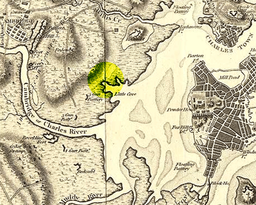
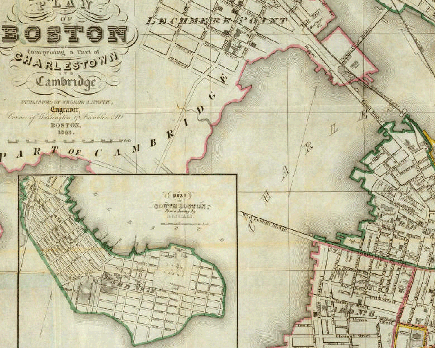
Boston, and its Environs [map]. Circa
1800. Scale not given. Archiving Early America. <http://earlyamerica.com/earlyamerica/maps/bostonmap/bostonmap.jpeg>
(March 2004).
|
| Cambridge
Port’s accessibility for suburbanization arrived in the form of
the West Boston Bridge. What is now the Longfellow Bridge and the original
layout for Main Street first appeared in an 1846 “Plan of Boston”
(Smith). While the bridge may have already been constructed, the roads
leading away from the river were still paper streets and did not always
rest on existing land. However, this plan provided the basis for a grid
of streets between Main Street, Harvard and Broadway after they diverged
at the end of the West Boston Bridge (G. M. Hopkins and Co.). The cross
streets were straight but created less-than-rectangular blocks because
Main Street and School Street never ran parallel to Harvard and Broadway.
The triangles created when this imperfect grid intersected Front Street
and its parallel at Lafayette Square is anything but square. At the
time, however, the streets where small enough that the unusually plots
were not also insignificant. Nor were these roads intended to be used
as frequently as Broadway and Harvard which provided more direct access
to West Cambridge. Cambridge Port had not intended to become an important
crossroads. As Jackson points out in Crabgrass Frontier: The Suburbanization
of the United States:
|
|
|
|
“According
to Henry Binford, [the unannexed villages of Cambridge and Somerville]
developed three important suburban characteristics between 1800 and 1850:
a set of clear municipal priorities, a preference for residential over
commercial expansion, and a stubbornness to remain politically independent
from Boston. [… The] early suburban residents differed from later
commuters because they did not use public transportation and because their
original residences were located on the periphery, not in Boston”
(Jackson p. 21). |
|
Smith, George
G. Plan of Boston Comprising a Part of Charlestown and Cambridge
[map]. 1846. Scale not given. David Rumsey Collection. (March 2004).
|
| |
| The only
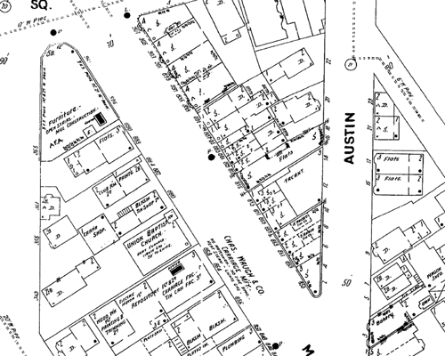
buildings noted on an 1874 map, for instance, are a school and church.
These support Binford’s claim and identify the few blocks just north
of Little Cove as a suburban community (G. M. Hopkins and Co.). Thus,
the area just north and south and at the westernmost end of Main Street,
although still adjacent to the marshy Charles River in the mid-nineteenth
century, developed into a wealthy residential suburb of Boston. |
|
 |
| |
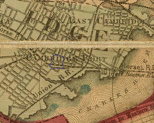
| With
the advent of public transportation, Cambridge Port developed a commercial
front to present to Main Street’s increasing crowds. By 1860, not
only were the Union Railroad and commuter lines in place, but a new horse
railroad also brought people from West Cambridge and Brighton into what
is now Central Square, down Main Street, and into Boston (Walling). Catering
to its new traffic, “Peripheral towns [like Cambridge] patterned
themselves after urban models and sought to project an image of dynamic
growth” (Jackson p. 46). By 1900, the blocks on Main Street boast
tightly packed shops – a furniture store, metal polishing shop,
a printing studio, a bakery, and some offices, for example. At least initially,
while Cambridge Port was still considered part of the periphery of Boston,
it continued to exist as a suburb. |
|
| |
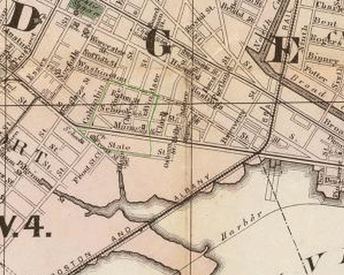
G. M. Hopkins and Co. Boston,
and its Environs [map]. 1874. Scale not given. David Rumsey Collection.
(March 2004). |
| |
 |
|
|
 |
| Walling, H. F. Map of Boston
and the Country Adjacent, from Actual Studies [map]. 1860. Scale not given.
David Rumsey Collection. (March 2004). |
|
Cambridge, MA [map]. 1900. Scale not given.
“Sanborn Fire Insurance Maps, 1900-1940 vol. 1, 1900, Sheet 75”.
<http://sanborn.umi.com/ma/3701/dateid-000001.htm>. (March 2004). |
| |
|
 |
|
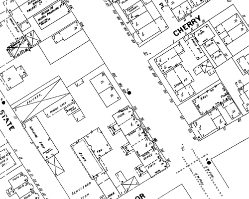
However, as improved transportation brought the community
into closer contact with the city and surrounding suburbs, a new industrial
culture began developing as well. In general, for “the nineteenth-century
metropolis, industrial location was largely determined by steamships and
railroads. Where they met, and only there could factories […] fuel
industrial enterprise” (Jackson p. 113). While Cambridge Port itself
was not a center of industrial growth, it developed near these hubs and
supported its own share of factories. The Home Spring Bed Co. and Blacker
and Shepard’s furniture manufacturing buildings on State Street
and the Hayward Confectionary Co. on Main each took up large sections
of land that indicate large-scale manufacturing. Perhaps the most telling
evidence of industry and the most disruptive to the residential community
would even be recognized today: a machine shop and junk yard (Sanborn
1900). Hand in hand with these factories were the homes of lower class
workers who could not afford to commute to work in Boston. For instance,
a “Chine Laundry” indicates the presence of immigrants, and
crowded rows of flats near the junk yard and tenements just farther east
hint toward a population of increasingly higher density and lower income.
|
Cambridge, MA [map]. 1900. Scale not given.
“Sanborn Fire Insurance Maps, 1900-1940 vol. 1, 1900, Sheet 75”.
<http://sanborn.umi.com/ma/3701/dateid-000001.htm>. (March 2004).
|
|
|
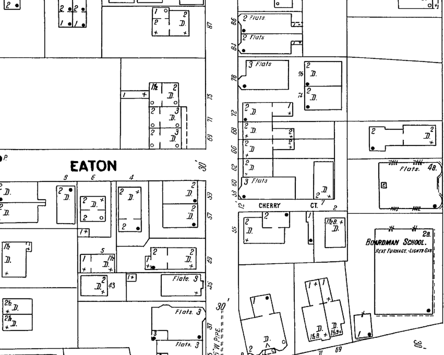 |
However damning this evidence may appear, the blocks within
the site continued to foster a suburban culture. Just outside of the city
and the railroad ring with its industrial and immigrant workers “lay
the new streetcar suburbs, the essence of the American achievement at
the turn of the century. The residential structures that filled them were
not elegant, but they were spacious and affordable” (Jackson p.
137). In general, “by 1870 detached housing had clearly emerged
as the suburban style […]. […] Occasionally, a double house
appeared, but it provided separate entrances and thick party walls, and
designers emphasized that it was only a transitional structure for families
on the way up” (56-7). These homes were exactly the sort that appeared
on 1900 maps -- single or double homes, complete with yards and porches.
Some residents, especially those behind the shops along Main Street, lived
in flats, but by the 1870s, even apartment had become acceptable (90).
The houses that exist on the site today represent the balloon frame construction
that had just gained popularity in American culture, and many of the buildings
have not moved from their original locations. As further evidence of a
residential community, within these few blocks stood a Union Baptist Church,
a Russian Zion Church, a Hall (perhaps a town hall), and the school that
named School Street – Boardman’s School. By 1900, the area
had reached its built-out point. While the buildings’ functions
continued to change, the two cultures they had taken so long to define
did not. |
| Cambridge, MA [map]. 1900. Scale not given.
“Sanborn Fire Insurance Maps, 1900-1940 vol. 1, 1900, Sheet 50”.
<http://sanborn.umi.com/ma/3701/dateid-000001.htm>. (March 2004). |
|
| |
|
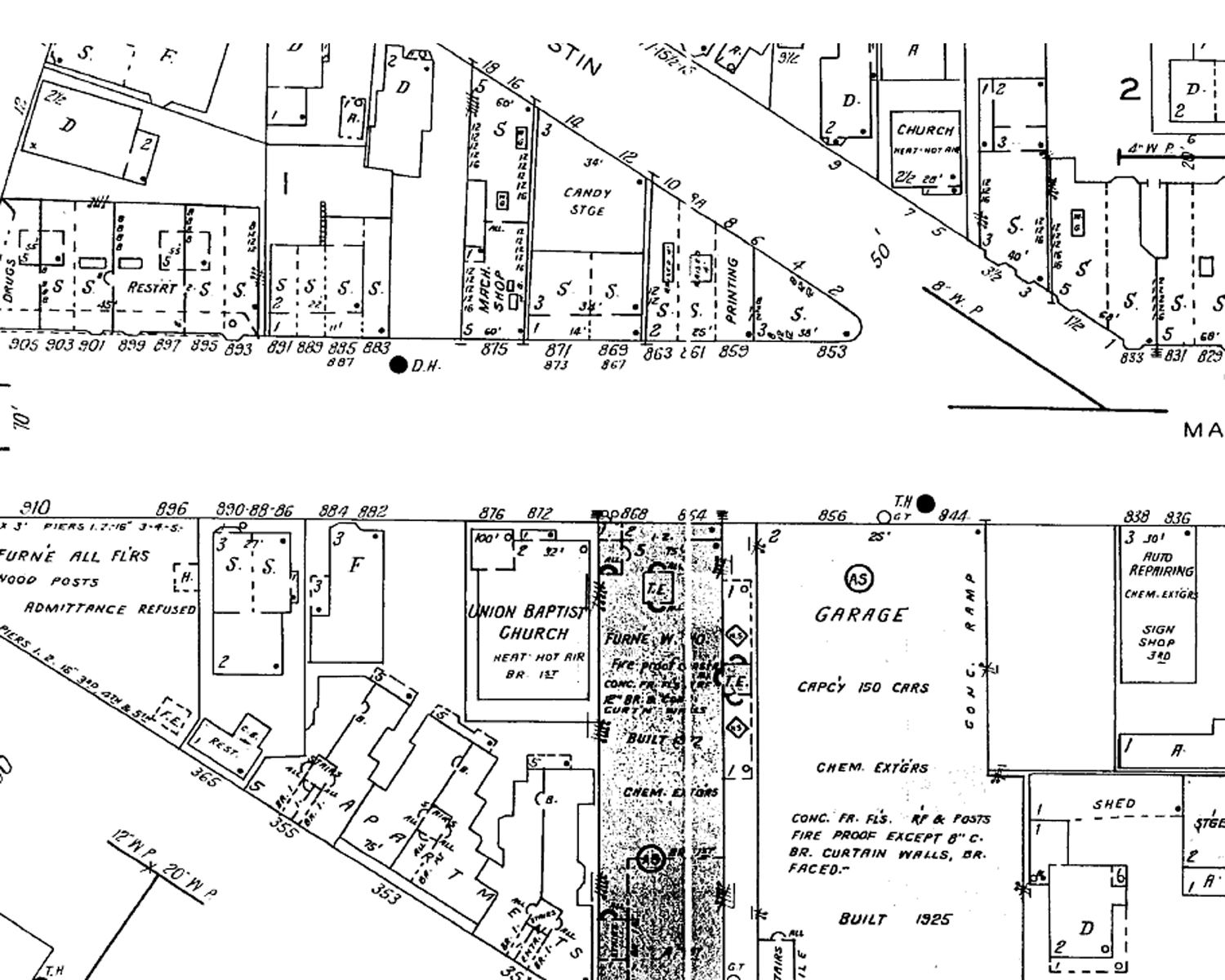
| If anything, the Great Depression separated these two parts
of the community even more. Industrially, the automobile had taken over.
Even during the Great Depression, “the automobile never retreated.
In all but the three deepest depression years, motor-vehicle registrations
continued to rise” (Jackson p. 187). And so by 1934, a gas station
appeared on Columbia Street, and the block just south of Main Street boasted
two garages to house 150 and 40 cars apiece, benefiting the small shops
along the two main streets and the candy factory that moved to the southern
side of Main Street. Only one prominent section seemed to have declined
so far that it had to be razed – leaving a tall brick wall to act
as a billboard for an oatmeal advertisement that can still be seen today.
The residential community suffered, but showed some strength in the structures
it chose to erect. Some of the small homes became flats or were divided
into smaller homes. Two additional churches appeared, one occupying the
Hall. But perhaps the most telling change was the construction of a Community
House in the place of a cluster of smaller sheds. And perhaps the most
tragic was the school’s abandonment and subsequent vacancy. Overall,
this intersection’s record during the Depression was impressive.
Only a few lots were vacated; only a few were destroyed; and even the
buildings proclaimed that the earlier sense of community had improved.
|
 |
| |
Cambridge, MA [map]. 1934. Scale not given.
“Sanborn Fire Insurance Maps, 1900-1940 vol. 1, 1934, Sheet 47”.
<http://sanborn.umi.com/ma/3701/dateid-000001.htm>. (March 2004). |
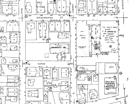
| The structure of the communities have changed
even less since then, following the trends of society but not reaching
much farther than that. By 1950, the largest parking garage had become
an auto body shop and today still houses vehicles in the guise of a U-Haul.
The filling station on Columbia Street branched out into a motorcycle
dealership and another took the place of the furniture shop at the acute
intersection of Massachusetts Avenue and Main Street. However, both joined
the “More than one hundred thousand gasoline stations [that …]
have been eliminated in the last decade” (Jackson p. 271). The James
O. Welsh candy facility developed the commercial section by establishing
stores along Main Street that are now restaurants and offices. The residential
community has not remained completely static either, converting the vacated
school into a recreation center and later into some sort of continuing
education facility. And in order to rectify the encroachment of one industrial
block into residential domain, a new recreation center was just completed
in place of the J. W. Greer Co. buildings. Individual facilities may have
changed, but in the last half century, the overall culture of this intersection
has not. |
|
 |
 |
|
Cambridge, MA [map]. 1950. Scale not given.
“Sanborn Fire Insurance Maps, Cambridge 1934-Mar.1950vol.1,1934-Feb.1950,
Sheet 42 ”. <http://sanborn.umi.com/ma/3701/dateid-000001.htm>.
(March 2004). |
| |
Changes in land use and ownership of these few blocks in Cambridge
only provide slight clues as to the overall health of the site. And while
most of the buildings are in use and have been recently painted, the site
appears slightly rough around the edges. This could be the influence of
the somewhat overbearing industrial and commercial section, of an unconcerned
residential community (which is difficult to believe from the evidence
provided in the Sanborn maps), or of the continued pressure between the
two. Whether the section would appear more stable if the two parts had
been integrated at some point is questionable. And if further development
continues in the same direction as that experienced in the last fifty
years, such integration will remain untested.
|
| Jackson, Kenneth T. Crabgrass Frontier:
The Suburbanization of the United States. New York, New York: Oxford
University Press, 1985. |
| |
| |
| |
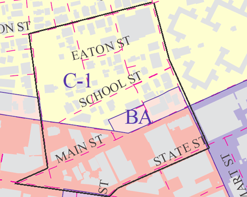
City of Cambridge Zoning
Map [map]. 2001. Scale not given. <http://gis.cambridgema.gov/maplibrary/zoning.html>.
(March 2004).
|
|
| |
| |
| |
| |
|
| |