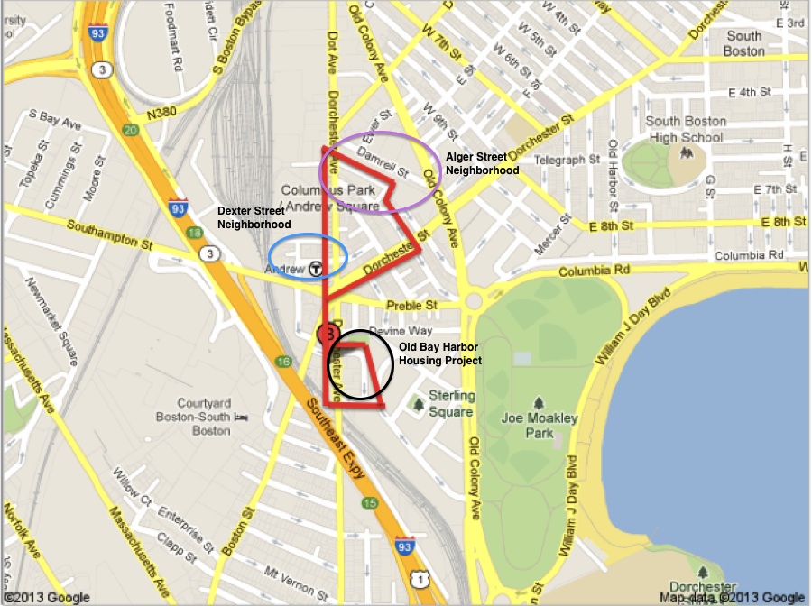
Andrew Square has stark juxtapositions. How can dirt-covered lots littered with garbage and glass neighbor finely preserved late 19th century dwellings? Choice sections of the site, such as Middle Street, are well maintained while others, such as Dexter Street, wear their age poorly. There is common agreement amongst the different neighborhoods to preserve the history of Andrew Square. Reviewing maps of the site revealed how little has changed in the past 120 years. With most buildings intact and streets unchanged, the land is bountiful with artifacts and traces from the past. How neighborhoods have chosen to celebrate their community and grander history reveals much about how the land might be developed and which stakeholders have the most control.
Andrew Square. Google Maps.
Dexter Street Neighborhood
The combination of historic charm and modern clutter along Dexter Street is striking. At the corner of Dexter Street and Dorchester Avenue is a commercial unit. Sanborn Maps show that it was originally a residential property (Sanborn Map Company). The curly-Q wooden accents on the doorway are a plain observer’s way to gauge that the dwelling was built during the late 19th century. Almost all of the late 19th century homes on the site share this decorative detail. In contrast to the entryway of the commercial unit, the door has a colorful poster advertising in English and Spanish for income tax filing. The rest of the street has remained residential. Many of the dwellings are still multi-family homes. The few number of cars suggests that some of the original units were combined to form larger living spaces. While Sanborn maps reveal that all the dwellings are brick, they have all been covered with siding. On one house, the peeling siding exposes layers underneath (Figure 1). The house has been covered multiple times, and each time new siding is added on top instead of replacing the old siding. The shoddy workmanship is an example of the haphazard upkeep of Dexter Street. The paint on the decorative woodwork on all the homes is chipped. The tiny lawns afforded by the small lots are littered with faded plastic lawn decorations and miscellaneous goods. While the neighborhood nods to its historic past, its vibe is really dominated by the T stop next door.
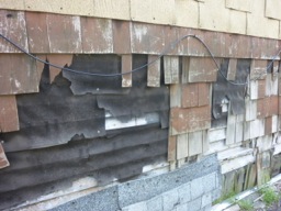
Figure 1. Layers of siding on a house in the Dexter Street neighborhood.
The Dorchester Underground Tunnel has seen many changes since it was created in the early 20th century. Flats were cleared to make way for its construction. I did not find any evidence of the pre-existing homes. There is constant bustle as people come and go from the subway and public buses. A partially enclosed structure covers bus lanes that are, at the earliest, a mid-century addition. The use of huge panes of glass in the structure suggests that it is a modern addition, sometime during the past few decades. There is a mysterious art piece inside the station (Figure 2). A placard nearby names it the “Andrew Station Time Capsule,” and is dated to 1993. While the figure clearly displays the art, in real life the glass is so dirty that you cannot clearly see inside. The piece’s existence demonstrates that the historic and locally cultural significance of the station is recognized. Its poor maintenance is in line with the rest of the neighborhood. By Dexter Street, the nods to the past are just that; there is no effort towards a longer conversation.
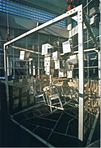
Figure 2. “Andrew Station Time Capsule.” Ross Miller.
Alger Street and Northwards
The area by Alger Street has been zoned for commercial and industrial use since at least 1889- the earliest Sanborn map found with the neighborhood (Sanborn Map Company). It has much more of a mix of old and new than the Dexter Street neighborhood. Next to an early 20th century factory building is an auto shop. New streetlights line what was home to the Howard Iron Foundry (Sanborn Map Company). The more frequent turnover of building ownership reflects global changes in technology and the short life of some industries.
The filling of South Bay during the late 19th century was the first of many changes in transportation that affected how a viable location Andrew Square was for manufacturing companies. In Power of Place, Hayden details how spaces shape economic production (Hayden 20). All the industrial sites are located between what was South Bay and the Old Colony Railroad. South Bay provided a connection to Boston Harbor by travelling up the Fort Point Channel. The Old Colony Railroad connected Boston to other northeast cities and suburbs. While both disappeared at the turn of the century, the land and buildings that existed were already primed for manufacturing businesses. The New York New Haven Railroad opened as an alternative transportation means. It is still in operation and runs parallel to Dorchester Avenue. The wood machines manufacturing company, S. A. Woods Machine Company, highlights the relationship between manufacturing and transportation. The S. A. Woods Machine Company existed on site pre-1889 and through the mid 20th century (Sanborn Map Company). It slowly occupied more land along Damrell Street and even gobbled a street to create more space for its manufacturing plant. Along Alger Street there is a trace of the railroad that used to connect the New York New Haven Railroad to the plant (Figure 3). The railroad has since been covered with asphalt. The emergence of mega-highways during the mid 20th century changed how industrial companies could construct their operations. The Southeast Expressway opened in the late 1950s beside Andrew Square. More expansive highway networks offered companies another option for transporting their goods. In addition to changes in transportation, changes in other technologies have affected the turnover rate of businesses.
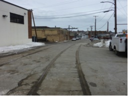
Figure 3. Remnants of railroad tracks on Alger Street.
Changes in technology partially explain why few of the buildings have maintained their original use. The B. Davis Company building happened to be open during my latest visit. It was stuffed floor to ceiling with boxes of supplies and there was no metal working equipment in sight. Metal industrial companies have consistently disappeared from the Boston Harbor since their prime in the early and mid 20th century during World War I and II. What once housed a saw and tooling manufacturing company has since been home to a number of commercial enterprises. Two large signs label different businesses: G F Importing Company, Inc. and Home Video Entertainment. The food company is most likely more recent because “Greek Imported ---- Foods” is written on top of “Home Video Entertainment” and has since faded. Few video rental stores exist nationally after the advent of Netflix and other online movie streaming websites. The diversity of companies that can utilize the space means an unpredictable future for the site.
Detailed brickwork distinguishes buildings constructed in the early 20th century from later architecture. Sometime between the 1899 and 1923, a stretch of tenements was cleared along Alger Street and a long brick building was erected. The Babcock Davis Company used it until the 1980s to produce steel and iron works (Sanborn Map Company). The building hugs its trapezoid-shaped property line to maximize the interior space. On one corner that can be seen from Dorchester Avenue, the brick is laid crisscrossed (Figure 4). Fine architectural details are absent from the modern commercial buildings on site. Some other buildings from the same period are present on parallel Damrell Street. The street name was changed from Dorr to Damrell some time near the turn on the century. There is beautiful brickwork around the windows of two manufacturing companies: a saw and tooling manufacturing company, and to its right, a wood machines manufacturing company.
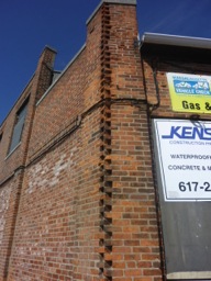
Figure 4. Intricate brickwork on early 20th century manufacturing building.
Enterprises today appreciate the functionality and aesthetics of their historical properties. Many turn of the century buildings north of Alger Street have large loading windows. There are remnants of lifts, which would have risen and lowered goods from the plant to a cart (Figure 5). In the figure, the well-used rusted outer door hides a newer metal door. It was unclear what type of company is currently using the building, but it found use for the large loading doors which are the perfect height for unloading onto 18-wheelers. Some property owners have chosen to restore the buildings highlight the beauty of the period brickwork. One of the S. A. Wood Machine Company buildings has been converted into multiple office units. For example, one unit is now home to a real estate development firm. Andrew Square’s location at the neck between Boston central and Dorchester makes it a prime location for urban and suburban commuters. There is a national trend of converting industrial buildings to smaller commercial or residential units. It is unclear whether the area can become a hub for other white-collar service businesses or will continue to be populated mostly by blue-collar service businesses, such as auto shops.
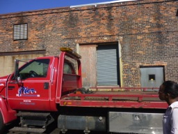
Figure 5. Old loading station and more modern 18 wheeler.
The longstanding history of industrial and commercial businesses on and north of Alger Street is imprinted into the local landscape. Some streets are named for industrial giants. For example, Alger Street is named for Cyrus Alger, a major played in Boston in the metal industry during the 19th century (Good Old Boston). Many of the late 19th and early 20th century industrial buildings have been preserved and are largely used by commercial companies. Cross Fit Southie cleared a warehouse off of Dorchester Avenue and converted it to a large gym space. One of the few historical placards in Andrew Square commemorates a veteran whose family owns a longstanding industrial companies. The sign shown in the figure is at the corner of Dorchester Avenue and D Street near Marr Companies headquarters (Figure 6). Most of the land by that intersection is owned by Marr, including the headquarter building, a warehouse, and a large lot that houses its cranes and lifts. Just as the S. A. Woods Machine Company was able to have a rail line built from its factory to the New York New Haven Railroad, one can expect local businesses to have a hand in the future of the site’s development.
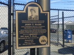
Figure 6. Placard for John T. Marr.
Old Bay Harbor Housing Project
The Old Bay Harbor Housing Project redefined the area of Andrew Square south of Hyde Street. Street names were changed, lots were reorganized, and the population of Andrew Square dramatically increased. Before the project was constructed, parallel running streets connected Dorchester Avenue to the Old Colony Railroad, later Old Colony Avenue. Historical maps showed that the lots between them were unoccupied for at least 40 years prior (Sanborn Map Company). It is unclear if there were ever plans to build residences or commercial businesses. Instead, the housing project exists as an artifact of post-Great Depression federal initiatives to how the country cared for its poorest citizens.
The newly minted streets in the housing project were named to celebrate the cultural heritage of South Boston’s Irish residents (Vale 177). The grid change disrupted the existing organized layout but permitted easier access to the thirty buildings in the project. Interestingly, many of the streets are named after military leaders: General Lawrence J Logan Way, Major Michael J O’Conner Way, and General WMH Devine Way. General Logan and Major O’Conner were commanding officers who died during the Spanish-American War (Boston (Mass.) City Council 595, Sixtyninth.net). One street is named for a religious figure, Monsignor Dennis F O’Callaghan Way. O’Callaghan was a longstanding reverend at St. Augustine’s Chapel north of the site (Toomey 39). While a large Polish community existed at the time of construction, and continues to, in the area, none of their heritage was reflected in the street names. The naming choice is exemplary of the general lack of care for the inhabitants of Andrew Square. Previous papers have cited city development plans to improve the quality of life to residents and travellers through Andrew Square. Nearly ten years later, there are still almost no trash receptacles on the streets while litter clutters storm drains. The lack of community appreciation and involvement in government efforts is concerning when considering future development projects.
Conclusion
With urban renewal in vogue, the fate of Andrew Square is in limbo. While its location is not suitable for high-end residences, for reasons detailed in previous discussions, it may be appealing for swaths of commercial businesses. The dominating forces are existing manufacturing companies, such as Marr, and the local government, whose actions, sometimes inaction, have demonstrated its lack of concern for local constituents. At the intersection of the main roads, Dorchester Avenue, Dorchester Street, Boston Street, and Southampton Street, is a mural commissioned by the Andrew Square Civic Association. While it is impossible to gauge their efforts so far, there is a mountain of work ahead. A civic association can preserve the voice of the community and ensure that Andrew Square’s neighborhoods continue to preserve their diverse history.
Works cited:
“69th Regiment.” Sixtyninth.net. Web. 30 April 2013.
“Alger’s Gun Works.” Good Old Boston. 31 January 2013. Web. 30 April 2013.
Boston (Mass.) City Council. Reports of Proceedings...Municipal Printing Office, 1899.
Google Maps. Columbus Park/Andrew Square. Map. 2013. Web. 30 April 2013.
Hayden, Delores. The Power of Place. MIT Press, 1995.
Miller, Ross. Andrew Square Time Capsule. 1993. rossmiller.com. JPEG file.
Sanborn Map Company. Cartographer. Boston Volume 4 Sheet 129. Map. 1889. Web. 30 April 2013.
Sanborn Map Company. Cartographer. Boston Volume 4 Sheet 68. Map. 1899. Web. 30 April 2013.
Sanborn Map Company. Cartographer. Boston Volume 4 Sheet 481. Map. 1923. Web. 30 April 2013.
Toomey, John J. History of South Boston (its past and present) and prospects for the future : with sketches of prominent men. Boston: The Authors, 1901.
Vale, Lawrence J. From the Puritans to the Projects: Public Housing and Public Neighbors. Harvard University Press, 2009.