Today, the Back Bay area holds many signs of its historical changes. The site I have chosen was built upon the major landfills in the 1850s. It is bordered by Massachusetts Avenue, Newbury Street, Public Alley 429 and 428, and Gloucester Street. The earliest Sanborn map of this site shows the layout of the land in 1887 (Figure 2).

Figure 2
Its distinct characteristics consist of single-family houses along Commonwealth Avenue and house-stable duplexes along Newbury Street. Comparing the 1887 Sanborn map to the present day map of the site (Figure 3), the most significant change is of land usage. Presently, Commonwealth Avenue is a residential street featuring apartments, Public Alleys are used for parking, and Newbury Street is used for commercial businesses. These changes were mainly brought about by the switch of horses to automobiles, the Great Depression in the 1930s, and economical status. Although these changes were major, traces of what the site once was can still be seen today.
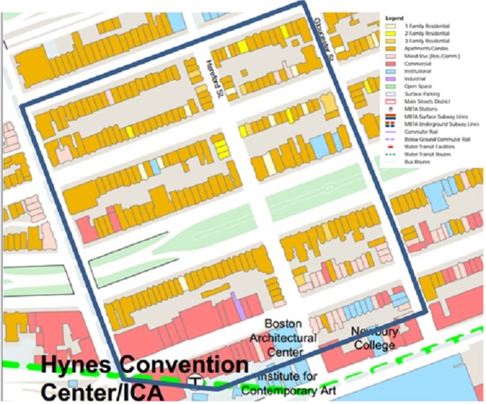
Figure 3
Commonwealth
Avenue
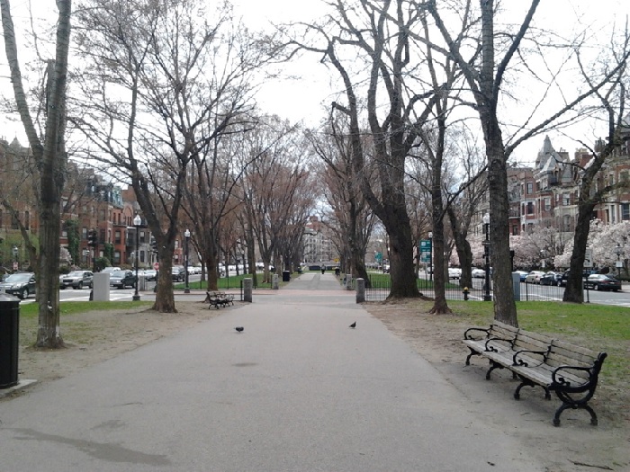
Figure 4
Commonwealth Avenue illustrates the influence of money and
the transportation revolution. Figure 4 shows a picture of Commonwealth Avenue
facing Massachusetts Avenue. This picture features Commonwealth’s grand
apartments, an underpass across Massachusetts Avenue, and a park in the middle.
In 1887, Commonwealth Avenue in particular offered a view on the park in the
middle, shelter for horses on Newbury Street, and fairly large houses. These
characteristics attracted the wealthy to move into Commonwealth Avenue homes or
build their own. But due to the Great Depression in 1930, many of the wealthy
had to move to the affordable suburbs in the Boston area. As a result, the
houses primarily turned into apartments. Today, these apartments still exist
and it seems that Commonwealth Avenue has again attracted the wealthy.
Changes from Houses to Apartments:
The Sanborn map of 1887 (Figure 2) shows a majority of
single-family homes on the site, as indicated by the yellow, with a few spots
still vacant. These were later to be filled in by more buildings. The houses on
Commonwealth Avenue really show the wealth of the owner. In Figure 5, the buildings
labeled 1, 3, 4, and 5 were all constructed around the same time by 1887.
Looking at these four buildings summarizes one type of housing style that can
be seen on Commonwealth Avenue today. These four buildings are very tall row
houses, but that is all they have in common. The architectural style of each of
these buildings is unique. For instance, in Figure 5, building 1 looks to be made
of stone and has a castle-like structure while Building 3 is less detailed and
is made out of brick. This is a clear indication that the land owners of each
lot were wealthy enough to hire their own architecture to design their homes.
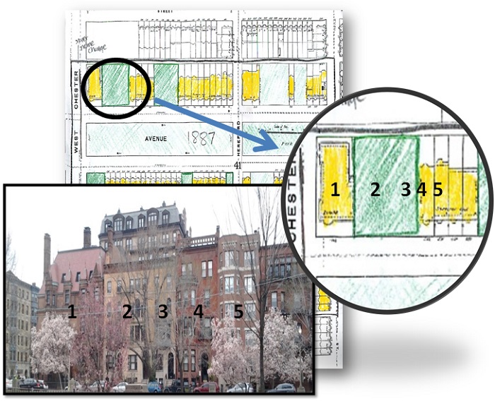
Figure 5
It wasn’t until The Great Depression of 1930 that the use of the buildings on Commonwealth Avenue changed dramatically. According to Jackson, “Between 1928 and 1933…the expenditures on home repairs fell by 90 percent,” (193). This describes the ‘fall’ of Commonwealth Avenue. No longer could the upper-class afford to stay in their large homes. It was much cheaper to sell their homes and move to the suburbs where houses were affordable. The house values dropped and those who still had substantial money found the opportunity to buy these vacant properties. To profit from them, one can assume that these owners would rent sections to the middle or lower class. This is how the single family homes turned to apartments. Today, it is apparent that the majority of buildings on Commonwealth Avenue are apartments or flats. One way to tell if a building in a residential area is an apartment, is to look for signs of multiple mailboxes or multiple entrances. The human perception of what the size a single-family row house has changed over the century. As a result, people are more willing to live in smaller homes as long as it is convenient for them.
Transportation:
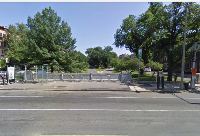
Figure 6
Figure 6 is
a picture of Massachusetts Avenue facing Hereford Street featuring the
Commonwealth underpass. The Sanborn maps up until 1974 show that Commonwealth
and Massachusetts Avenue once intersected. Figure 2 at the intersection of West
Chester Park and Commonwealth Avenue show the original lay of the land. But the
Sanborn map of 1974 (Figure 7) shows what exists today and is shown in the
picture. Since the ‘fall’ of Commonwealth Avenue during the Great Depression,
the transportation revolution (as later described) changed Commonwealth Avenue.
Commonwealth Avenue, that once featured single-family homes, turned into a
street that provided apartments. Not only did this lower the economic status of
the once famous street, but it also increased the number of car traffic due to
an increase in population. Sometime between 1937 and 1974 as the Sanborn maps show
(Figure 7), an underpass was dug out to, what one can assume, facilitate
traffic across the already busy Massachusetts Avenue. In Crabgrass Frontier, Jackson shows the exponential increase in
automobile registrations in the United States. Specifically related to the
creation of the underpass on Commonwealth Avenue, about 22.5 million cars were
registered in 1935. By 1974, more than 100 million cars were registered in 1975
in the United States (162). Therefore, the underpass helped ease traffic due to
the increase of cars in the Boston area.
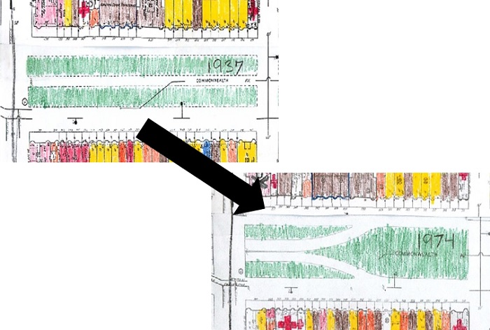
Figure 7
What the Future Holds:
With the
continue increase of population in the city, the trend of living in apartments
on Commonwealth Avenue will continue. Apartments are generally cheaper than
houses and the location of them on Commonwealth Avenue is even more convenient.
Just one block south of Commonwealth Avenue is the T stop Hynes Convention
Center. Two blocks northwest is Massachusetts Turnpike (I-90). A bus stop is on
Massachusetts Avenue (Figure 6) that hosts many popular buses. In addition to
the convenient transportation opportunities, the shops on Newbury Street
provide many clothing and food options. Commonwealth Avenue will remain a
residential street that will continue to attract the wealthy.
Newbury Street
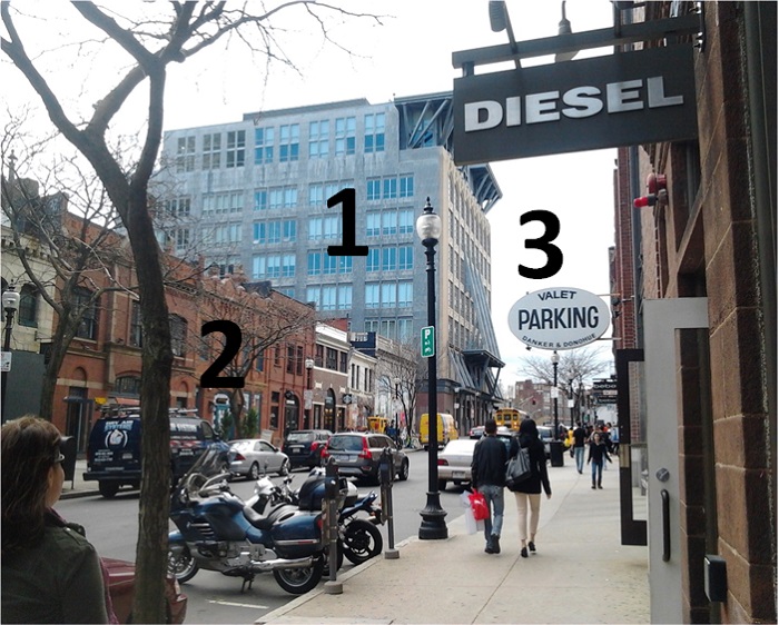
Figure 8
Newbury
Street illustrates the influence of the transportation revolution. Before the
Back Bay area was established by the 1850s, the Boston and Albany Railroad ran
through the south section of present day Back Bay. This affected the price and
size of the homes originally built there. Figure 8 displays traces of the
transportation revolution, as described in detail later. There are three layers shown in this picture
that have developed over time. Those three layers include the original
buildings on Newbury Street, parking garages, and new buildings. Signs that the
three-story buildings were once stables are seen in this picture. In addition
to the stables, garages that hold cars still remain.
But on the
next block of Newbury Street, there are no stables. One can assume that since
this block was further away from the noise and pollution of the Boston &
Albany Railroad, the homes were more expensive.
As a result, these residents could probably afford to store their horses
in the next block over. Today if one visits Newbury Street, one would see major
differences in the styles of the buildings between the two blocks.
Newbury Street between Massachusetts
Avenue and Hereford Street
1st Layer- Replacements of
Stables
The Sanborn
map of 1887 (Figure 2) shows the establishments of stables on the first block
east of Massachusetts Avenue as indicated by the gray. On the corner of Massachusetts
Avenue and Newbury Street is a Boston Cab Company powered by horses. On the
other corner of Newbury Street and Hereford Street is a livery where some
residents on Commonwealth Avenue probably stored their horses. Traces of these buildings no longer exist and
this is due to the transportation revolution.
The transportation revolution was jumpstarted with the
invention of the automobile. Jackson writes, “twenty- four American companies
where producing simply constructed automobiles at low prices…by 1913, there was
one motor vehicle every eight people…” (160). This is heavily due to the
success of Henry Ford’s ‘Model T’ automobile- an automobile that dropped from
$950 in 1910 to $290 in 1924. As a result, many people could afford cars.
Now that cars were affordable and more convenient, stables
were no longer needed. The livery on the corner of Hereford and Newbury Street
was turned into a garage. Traces that these stables once existed cannot be
found. In Figure 9, the picture on the left is what is now in the place of The
Boston Cab Company. The building on the right took the place of the livery. Looking at the succession of the Sanborn map
shows that the original buildings were torn down between 1914 and 1974. It is
evident that these buildings were built later because of the building material
types. The building in the left picture looks to be made out of stone. The
building on the right is made out of cement. The material types of these
buildings are very different from the original brick buildings found on Newbury
Street.
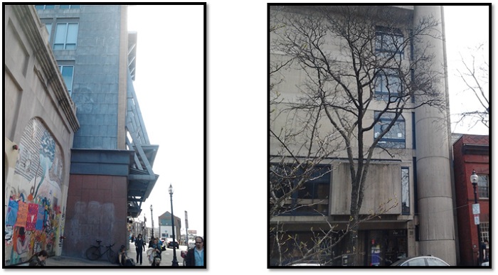
Figure 9
2nd Layer- Traces of
Stables
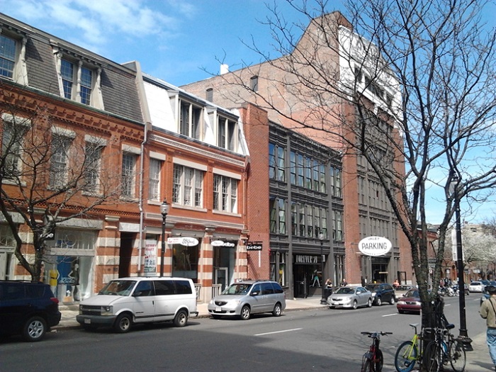
Figure 10
The smaller buildings on the first block of Newbury Street
that existed on the Sanborn Map of 1887 (Figure 2) shows signs that stables
were once there. The 1887 map shows that the stables occupied the first floor
and the living areas were upstairs. Because the buildings on Newbury Street
were built around the same time of the buildings on Commonwealth Avenue,
comparing them shows something very important about Newbury Street. On
Commonwealth Avenue, there are stairs leading up to the door. However, on
either side of Newbury Street, the entrance of these three story buildings
meets the sidewalk (Figure 10). Figure 11 below shows this difference.
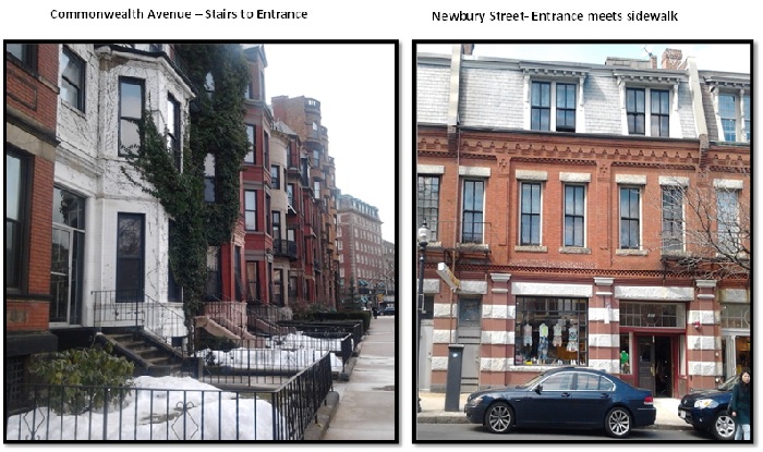
Figure 11
The
significance of this characteristic on Newbury Street is that it is a trace of
stables. The buildings on Newbury Street were probably designed this way to
easily accommodate the horses and carriages. Another important characteristic
about the entrances on Newbury Street is they are wide enough to fit horses and
carriages on the first floor (Figure 11). One can assume that the buildings
were built this way to accommodate poorer residents and their horses.
3rd Layer- Garages
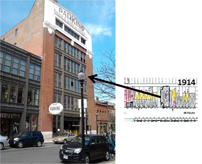
Figure 12
Because of
the transportation revolution in the early 1900s, residents of Newbury Street or
shoppers needed a place to store their cars. Figure 12 shows a picture of a
garage on Newbury Street. This building can be traced back to the 1914 Sanborn
map. The fact that this building is still standing is important. The original
use of this probably was to store the cars of Newbury Street residents. But as
the popularity of Newbury Street grew over the latter half of the 1900s,
shoppers probably parked their cars here. A good indication of why this is true
is the presence of the pay station shown in Figure 12. Neighboring residents
would be crazy to park their cars here today as parking is pricey.
Newbury Street between Hereford
Street and Gloucester Street
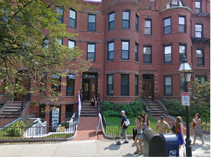
Figure 13
Figure 13
shows a row of houses on Newbury Street between Hereford Street and Gloucester
Street. As mentioned above, these buildings are very different from the
buildings between Massachusetts Avenue and Hereford Street. But what puts these
buildings in another category is they are taller (four stories compared to
three), grander, and the buildings are set back from the street with stairs to
the entrances. The size of these buildings, which were originally single-family
homes, show that the residents on this block of Newbury Street were better off
than those living west and closer to the B & A Railroad. The stairs leading
to the entrance show that these buildings were built to only house people and
that the residence were wealthy enough to house their horses a block over.
But
comparing these buildings to the ones on Commonwealth Avenue shows that these
residents were not as wealthy as the Commonwealth residents in the early 1900s.
The buildings shown in Figure 13 have the same architectural style and building
materials. Going back to Figure 5, the buildings there are varied in
architectural styling because residents hired their own architectures to design
their homes. One can assume that although the residents on this block of
Newbury Street were better off than the residents to the west, Commonwealth
Avenue by far housed the wealthiest residents in the area.
What the future holds:
Today, the
block of Newbury Street closest to Massachusetts Avenue holds many trendy
stores such as Urban Outfitters, Forever 21, and Patagonia. The next block of
Newbury Street holds small shops and boutiques. But the popular stores on the
first block of Newbury Street seem to attract more shoppers than the stores on
the second block; there is less foot traffic shown in Figure 13 compared to Figure
8. In the future, one can assume that the buildings on the second block will
accommodate popular clothing chain stores.
Public Alleys
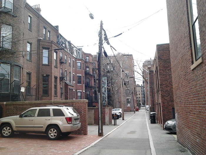
Figure 14
Details of
the Public Alleys are not shown on the Sanborn maps. However, Figure 14
provides many clues as to what the Public Alleys were once used for and how it
changed to what it is today.
The first
obvious use of the public alleys is for parking. Because of the transportation
revolution and the increase of car owners, both Commonwealth Avenue and Newbury
Street residents used the alleys for their own private parking space. But
before cars were invented, these alleys did not have any use and were vacant. Jackson
gives some indication of what they might have been used for: “…small rear yards
were apt to be covered with back-alley dwellings… Rear areas were usually less
than typically rancid, disreputable, and overrun by rodents,” (56). This leads
to another use of the alleys. Alleys were once used to store garbage. The trend
is kept up today, as seen by the presence of garbage cans, except collecting
garbage today is more civilized.
Overall, Public
Alleys are mainly used for parking. In the next couple of years, cars will continue
to be a necessity. Therefore, the use of the Public Alleys shows no sign of
changes in the immediate future.
Conclusion
Boston, Massachusetts
has gone through many changes since its establishment in the 1630s. But these
changes can be traced back to its early days. Referencing an early map of
Boston in the 18th century (Figure 1), the present-day shoreline
along the Charles River did not exist. What was once a body of water is now
land as a result of major landfills in the 18th century. The site I
have chosen was built upon the major landfills in the 1850s. It is bordered by
Massachusetts Avenue, Newbury Street, Public Alley 429 and 428, and Gloucester
Street. On the site lay three differently used streets: Commonwealth Avenue,
Newbury Street, and the Public Alleys.
Commonwealth Avenue
started out as a street where wealthy residents hired architecture to design
their homes. But the Great Depression of 1930s caused the outflow of these
residents and their houses were turned into flats or apartments. The
combination of the apartments and the transportation revolution brought about
car traffic through the street. As a result, an underpass was built to
facilitate traffic across the busy Massachusetts Avenue. Today, Commonwealth
Avenue is made up of mostly apartments. Since these apartment are in good shape
and in a convenient location (transportation and nearby stores), the cost of
living here will continue to rise and bring in the more wealthy.
The first block of
Newbury Street shows a few layers that occurred in the last century. The wide
building entrances at street level prove that past owners of these buildings
once stored horses. But with the influence of the transportation revolution, these
stables were turned into shops and the bigger stables were torn down to build
other buildings. Garages were also built to provide parking to the shoppers and
residents. Today and in the future, popular shops will continue to grow and
attract many shoppers.
The Public Alleys were affected the most by the automobile revolution. What started out as an unkempt place turned into parking spaces for those residents and employers. Today, it is mainly used for parking.
All of these experiences, as illustrated by the Sanborn maps, changed the site into what it is today. The photos holds the evidence of a past life and give us some indication of why Commonwealth Avenue is a residential street, why the Public Alleys are used for parking, and why Newbury Street is home to many shops today.
Works Cited:
Jackson, Kenneth. Crabgrass Frontier- The Suburbanization of the United States. Oxford: Oxford University Press, 1985. Print.
Maps:
Map 1974: Map from Digital Sanborn Maps (The Sanborn Map Company, Sanborn Library 1867-1970), showing Back Bay circa 1950,
Figure 2,7,12: Map from Digital Sanborn Maps (The Sanborn Map Company, Sanborn Library 1867-1970), showing Back Bay circa 1900, Date Accessed: March 2013, http://sanborn.umi.com/cgi-bin/auth.cgi?command=AccessOK&CCSI=254n
Figure 3: Map from Boston Redevelopment Authority , showing Back Bay circa 200, Date Accessed: March 2013, http://www.bostonredevelopmentauthority.org/pdf/maps/backbay.pdf
Figure 6: © 2013 Google Image Date: August 2009. Date Accessed: April 2013, https://www.google.com/maps?q=Massachusetts+avenue+and+commonwealth+avenue&hl=en&ll=42.34908,-71.088617&spn=0.002252,0.011523&sll=42.349272,-71.088702&layer=c&cbp=11,71.84,,0,5.13&cbll=42.34908,-71.088617&hnear=Commonwealth+Ave+%26+Massachusetts+Ave,+Boston,+Suffolk,+Massachusetts+02115&t=m&z=17&panoid=kh3EcHi-q6NZqfrg-pLn8g
Figure 13: © 2013 Google Image Date: August 2009. Date Accessed: April 2013, https://www.google.com/maps?q=Massachusetts+avenue+and+commonwealth+avenue&hl=en&ll=42.348919,-71.08503&spn=0.002252,0.011523&sll=42.349272,-71.088702&layer=c&cbp=12,169.58,,0,-5.18&cbll=42.348955,-71.084896&hnear=Commonwealth+Ave+%26+Massachusetts+Ave,+Boston,+Suffolk,+Massachusetts+02115&t=m&z=17&panoid=XgEUMa1HtzVlaTDj-H8IJg