Assignment 3: Changes Over Time
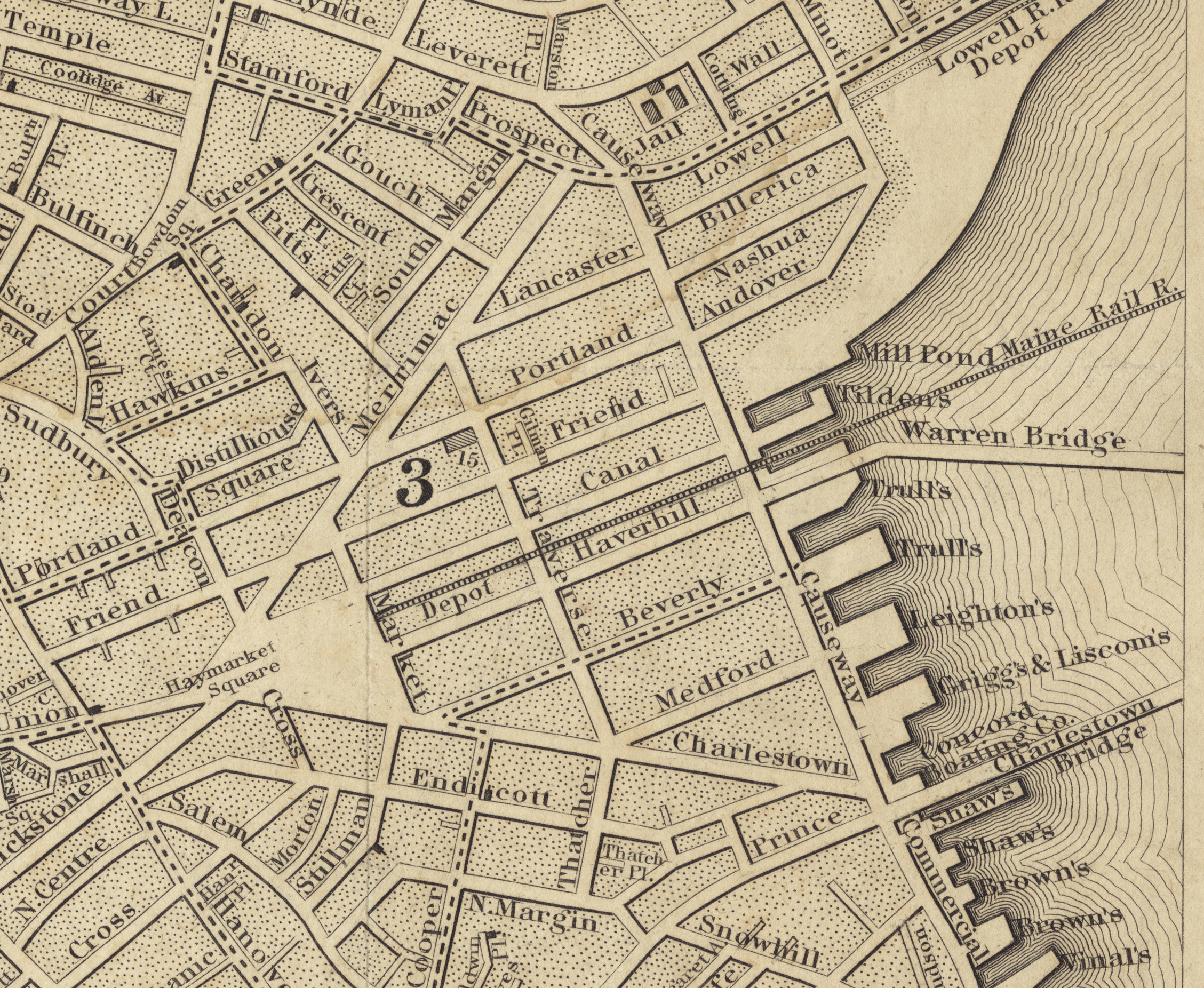
1844 Map of Boston that shows a rail line through the Triangle. Transportation would play a key role in the site’s development. Map reproduction courtesy of the Norman B. Leventhal Map Center at the Boston Public Library.1
While many neighborhoods in the North End have been completely demolished and rebuilt, Bulfinch Triangle has managed to keep the same street geometry since the day it was planned. However, the lack of obvious road discrepancies in the maps does not mean this site has not changed over time. In fact, it has undergone a subtle transformation as its land use changed in response to the nearby transportation infrastructure. The Bulfinch Triangle had a period of housing and outfitting horses for transportation to and from a nearby railroad and continued to grow as an industrial community for another period. It modernized and survived the Great Depression, and subsequently switched gears to providing parking and drinks to a nearby sports stadium as the decades passed.

1867 Map of the Bulfinch Triangle. Stables are abundant in the relatively large, loosely-packed lots, with this fire insurance map highlighting many of the highly flammable workshops in the area. Empty upper-right corner is due to an incomplete map, not an actual empty section. Composite map of Plates 5 and 6 of the collection, annotations by author.2
The Crossroad of Mechanical and Animal Transportation (1844-1867)
The post-Civil War Sanborn fire insurance map illustrates the loose layout and the transportation based land use of the site in 1867. The Bulfinch Triangle seems to have been a hub of horse-borne traffic to and from the adjacent railroads, with the many stables, blacksmiths, wheel wrights, and carpenters spread throughout the site indicating that horse carts were manufactured and serviced here. There were also a fair number of hotels and shops, suggesting that this area was travelled by foot, at the very least between getting off a horse cart and onto a train. Many of the stables are not marked as sale stables, however, so they may be the personal horses of the residents living there, or rented out like parking space. It is interesting to note that despite a few factories and machine shops, much of the industrial land use is by very traditional crafts like coppersmiths and coffin makers, which stand in contrast to the railroad nearby. While this is partly a product of the times, it also hints that the triangle was not prosperous enough to be outfitted with heavy industrial machinery at this time. Although they are not labeled as such, it is a fair assumption to think that the uncolored areas are living areas, as they would otherwise be labelled as a store or with their respective craft. It is likely that the site was originally intended for housing since it was built on the seaside in the middle of the city away from a port, with a railroad built later. The site was likely been in the process of transforming from a purely residential area to an industrial one to exploit the train station nearby. Regardless of how much land was being used for housing, the site clearly has strong economic ties to equine and rail-based modes of transport.

1895-1900 Map of Boston. Compared to the previous map, the Triangle is more densely packed with industry and stables. Composite map of Plates 23 and 27 of the collection. Annotations by author.3
Increasing Density and Manufacturing (1867-1900)
At the turn of the century, Bulfinch Triangle seemed to have grown to be much more modern, with fewer craftsmen and more factory manufacturing, especially furniture. The architecture is generally more crowded and consolidated than before, with more utility being made of the available land and smaller buildings fusing into larger ones. Concerning the furniture factory, there were many nearby factories that seem to supply it, like lumber, glass, and bedding warehouses nearby. There are also more stables, and more people manufacturing and selling horses and carriages. The replacement of the craftsmen industries was likely a combination of increasing volume of traffic and the industrial revolution stamping out smaller, more individual operations. There were also now a few dwellings and a tenement explicitly mentioned in the insurance map, though it is hard to determine for sure if their inclusion indicates that they were particularly affluent or the maps were simply becoming more detailed and thorough. It is quite likely that many of the stores and shops had housing in floors above. In contrast to the previous map, almost every small property is a store, with the larger ones being stables or factories, and every square foot of the site being put to use. While the Boston and Maine railroad from the previous time period has gone vacant, Union Station was now labeled, most likely the only railroad that this site fed to at the time. The increasing density of buildings, stores, and industries suggests that this site grew in prosperity during this period, likely as a result of traffic brought from Union Station.
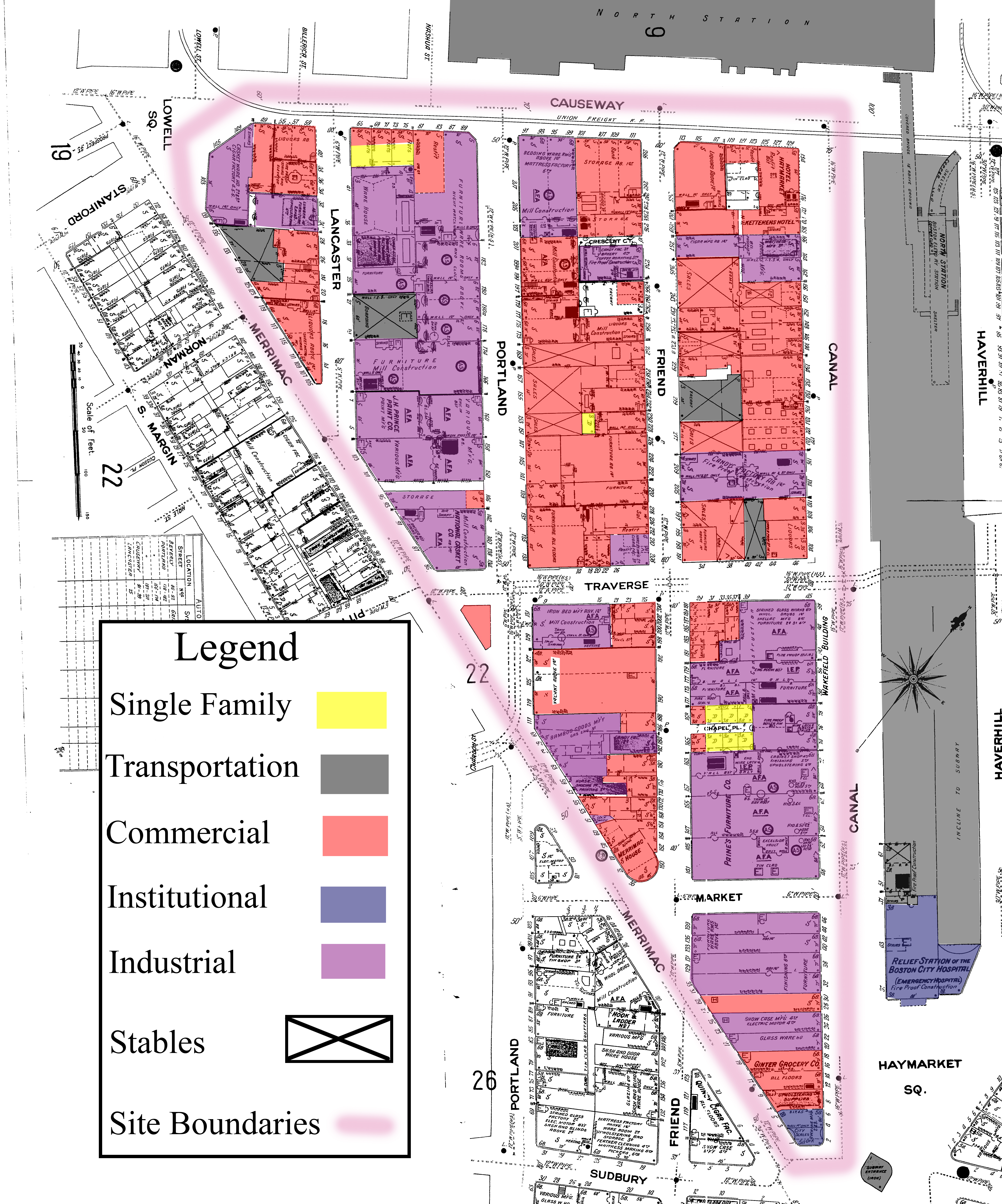
1908-1938 Map of the Bulfinch Triangle, with several vacant lots, though very similar to the previous period. Composite of Plates 23 and 27 of the collection. Annotations by author.4
Modernization into the 20th Century (1900-1938)
This period marked the Bulfinch Triangle’s development into the next century, marked by subtle changes due to transportation technology and economic factors. By 1938, this half of the Bulfinch Triangle had fewer stables, which was reasonable given the advent of the automobile. However, there were still a few stables remaining and no parking lots yet, suggesting that the transition to automobiles was not instantaneous and that horse-borne transportation must have still been very important. There were also a few vacant lots, perhaps marks of bankrupt businesses due to the Great Depression. The Union Station had been renamed North Station, having absorbed the vacant track of the Boston and Maine Corporation, an indication that the Bulfinch Triangle likely continued to grow in importance as a transportation hub. What was previously the Boston and Maine Corporation track has been labeled “Incline to Subway,” meaning that the commuter train had likely been moved underground. The land was still heavily used for industrial purposes, though with candy and printing industries in addition furniture and casket-making. Diversification of the industries could mean that as the needs of the nearby citizens grew more complicated, the industries in the city retooled to keep in pace. This period reflects the least amount of change compared to other periods, likely because of the Great Depression and World War II stifling any major building changes. The most telling change of the time period however is the reduction in the number of stables, due to the inception of automobiles, an indication of the importance of transportation technologies to the Bulfinch Triangle.

1929-February 1951 Map of the Bulfinch Triangle, with much of the area dedicated to parking space. The site remains like this to this day. Map composite of Plates 15 and 16 of the collection. Annotations by author.5
Parking and Housing (1939-1951)
Bulfinch Triangle in the middle of the 20th century represented the transition from a manufacturing and industrial region into a commercial and housing area. This map also shows the completed transition from horse power to gasoline power, with many parking spaces created and the total disappearance of stables. As can be seen on the next map of the present-day Bulfinch Triangle, many of the parking spaces allotted by 1951 remain even today. It seems unlikely that urban renewal was the cause of the buildings being torn down because only a few, scattered buildings were taken down instead of the whole block. More likely than not, those buildings were simply falling apart and taken down instead of being left condemned. While the Triangle always had substantial space dedicated to stables, the transition to parking lots indicates more than just the change in the mode of transportation of the day. Horse-drawn vehicles were serviced and produced at the site in the 19th century, while automobiles were not, relegating this site to a much smaller importance than before since it would no longer be industrially productive due to its proximity to the train station. Much of the manufacturing seems to have moved away and been replaced by housing, with there being more group housing labelled than before. However, it is still much more housing than the map shows, since every single upper floor of those buildings would then have to be empty or dedicated to commercial or manufacturing needs as well. The Boston Garden was built in 1928 and would likely have contributed greatly to the transition of the Bulfinch Triangle into a commercial center. Given that the stadium was most likely built on where the train station was to take advantage of the space and preexisting infrastructure, the Bulfinch Triangle was almost handed over from the transportation to the sports industry with that change. This period lays the foundation for what the Bulfinch Triangle is now, with stables and buildings turned into parking lots, and manufacturing turned into stores, saloons, and restaurants to serve sports fans of the Boston Garden.
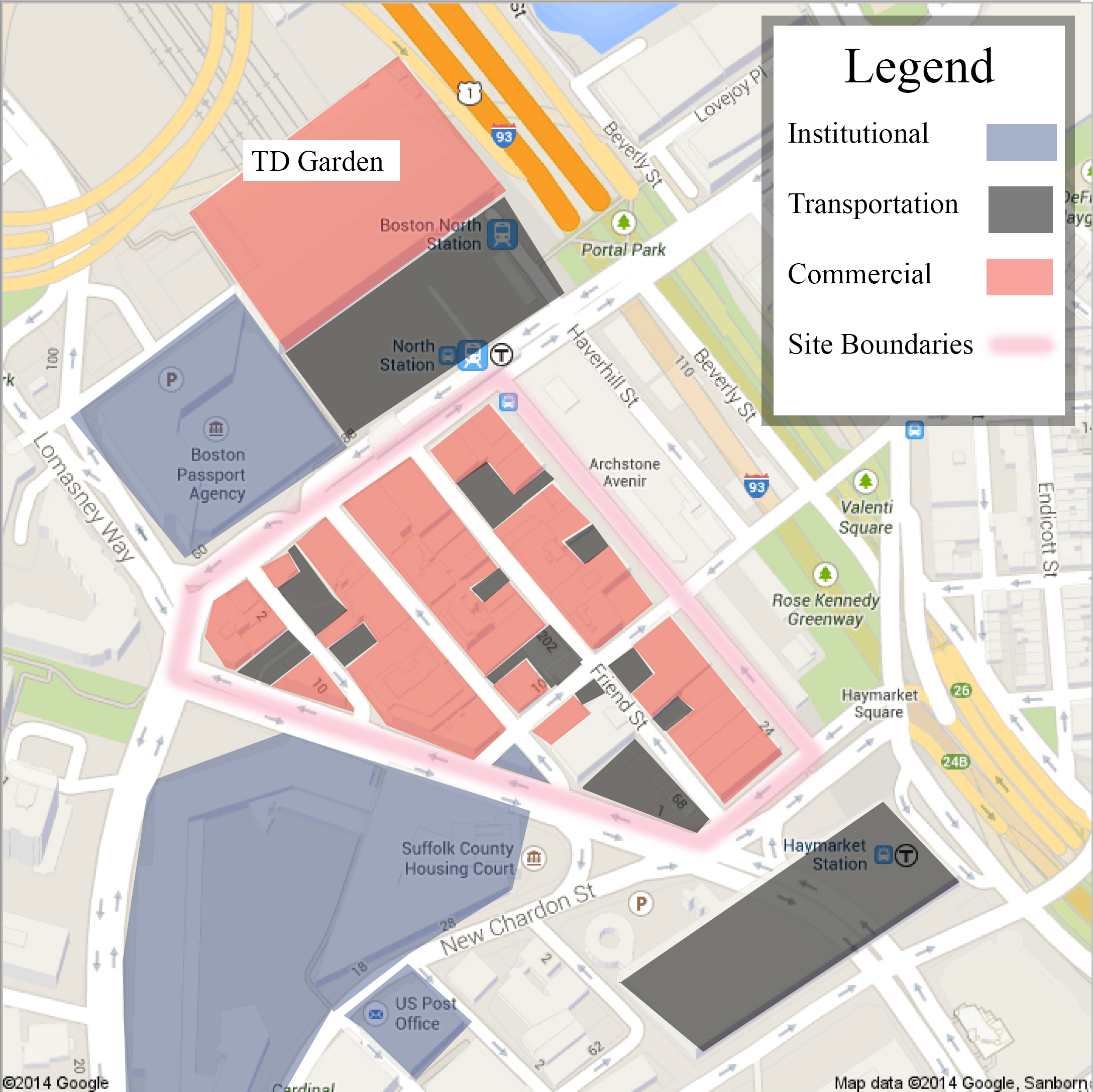
2014 Map of the Bulfinch Triangle. TD Garden is one of the biggest influences on the site today, and its position between two T stops ensures that there is always foot traffic. Annotations by author.7
A Neighborhood Dependent on Sports
The Bulfinch Triangle today very much reflects its mid-20th century counterpart, both in geometry and land use. While the Boston Garden was replaced with TD Garden in 1995 , the change would only be a subtle one in the scope of these maps, as both were sports arenas for the city of Boston. Exploring the Triangle on foot makes the effect of the TD Garden sports stadium immediately apparent, with paid parking space and sports bars and pubs lining the streets. The neighborhood’s juxtaposition of historic architecture with and modern dining and drinking venues represents a compromise that attempts to juggle preserving a piece of architectural history and maintaining profitability in the modern world. Much like how it has been difficult to determine from the fire insurance maps how many people were using the upper floors of their industrial or commercial spaces as a residential space, it is difficult to determine today how much housing there is in the Bulfinch Triangle today. While almost every building certainly has second, third, and even fourth floors, it is not immediately obvious if they are used for storage for the store on the ground floor, office space, or simply vacant. These upper floors retain their old flavor, as most owners don’t seem to bother making the upper floors look as modern and new as the ground level stores. One interesting, very modern change is the consolidation of buildings outside the boundaries of the site. While there had previously been many smaller buildings, the area across Merrimac was consolidated into a courthouse, the northwest plot across Causeway transformed into a passport agency, and much of the Haymarket Square to the southeast along with the tip of the Triangle was consumed by a multi-story parking complex for the TD Garden. The site is a literal slice of “old Boston” among very large and modern buildings built for today’s needs, demonstrating a neighborhood’s attempt to keep pace with changing needs and resources without being rebuilt from the ground up.
This half of the Bulfinch Triangle has survived two hundred years with much of its geometry and footprint remaining very similar. From 1867 to 2014, the Bulfinch Triangle has gone from supporting a transportation hub with stables and blacksmiths, to supporting a sports arena with pubs and parking lots. While it may seem that the Triangle is subject to the whim of the infrastructure in its proximity, its changes can be more fundamentally traced back to the much larger force of technological advances in transportation. While the individual scenarios of this site has definitely affected how it has changed, overarching national and global forces have played a very pivotal role in the site’s development, such as railroads, automobiles, and subway systems. Even though it was probably through pure chance and coincidence that the Bulfinch Triangle avoided being torn down for one reason or another, the fact that it is defined as a historic site today means that it will continue to wear its old worn bricks proudly. Preserved like an ancient insect in Amber, Bulfinch Triangle shows very clear growth rings marking its changes throughout two centuries.
1 Boynton, George W. Plan of the city of Boston. Dickinson, Samuel N., 1774. Map. maps.bpl.org/id/10941
2 Sanborn Company. Insurance Maps of Boston, Massachusetts. New York. Map. 1867. http://sanborn.umi.com.libproxy.mit.edu/ma/3693/dateid-000001.htm?CCSI=254n
3 Sanborn Company. Insurance Maps of Boston, Massachusetts. New York. Map. 1900. http://sanborn.umi.com.libproxy.mit.edu/ma/3693/dateid-000001.htm?CCSI=254n
4 Sanborn Company. Insurance Maps of Boston, Massachusetts. New York. Map. 1938. http://sanborn.umi.com.libproxy.mit.edu/ma/3693/dateid-000001.htm?CCSI=254n
5 Sanborn Company. Insurance Maps of Boston, Massachusetts. New York. Map. 1951. http://sanborn.umi.com.libproxy.mit.edu/ma/3693/dateid-000001.htm?CCSI=254n
6 Munsey, Paul and Suppes, Cory. “The Boston Garden.” Ballparks. http://basketball.ballparks.com/NBA/BostonCeltics/oldindex.html
7 Map data: Google, Sanborn. Google Maps. Map. maps.google.com
8 TD Garden. "The Garden." TD Garden. www.tdgarden.com/the-garden/
Bibliography
Boynton, George W. Plan of the city of Boston. Dickinson, Samuel N., 1774. Map. maps.bpl.
Map data: Google, Sanborn. Google Maps. Map. maps.google.com
Jackson, Kenneth T. Crabgrass Fronteir: The Suburbanization of the United States. New York: Oxford University Press, 1985
Munsey, Paul and Suppes, Cory. “The Boston Garden.” Ballparks. http://basketball.ballparks.com/NBA/BostonCeltics/oldindex.html
Sanborn Company. Insurance Maps of Boston, Massachusetts. New York. Map. 1867. http://sanborn.umi.com.libproxy.mit.edu/ma/3693/dateid-000001.htm?CCSI=254n
Sanborn Company. Insurance Maps of Boston, Massachusetts. New York. Map. 1900. http://sanborn.umi.com.libproxy.mit.edu/ma/3693/dateid-000001.htm?CCSI=254n
Sanborn Company. Insurance Maps of Boston, Massachusetts. New York. Map. 1938. http://sanborn.umi.com.libproxy.mit.edu/ma/3693/dateid-000001.htm?CCSI=254n
Sanborn Company. Insurance Maps of Boston, Massachusetts. New York. Map. 1951. http://sanborn.umi.com.libproxy.mit.edu/ma/3693/dateid-000001.htm?CCSI=254n
TD Garden. "The Garden." TD Garden. www.tdgarden.com/the-garden/