May 3, 2014 - Entry 12
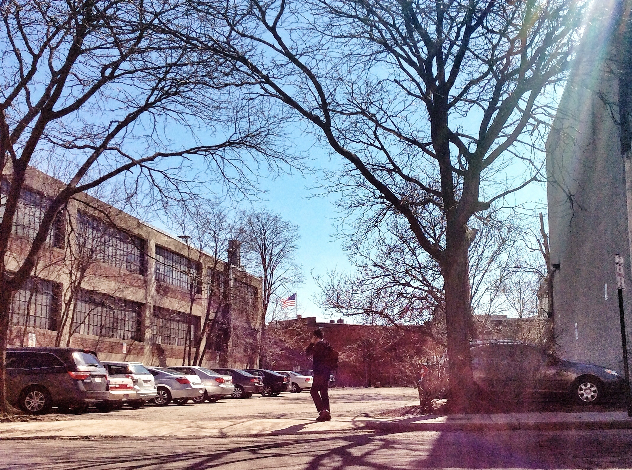
The first round of presentations focused on the importance of transportation and accessibility in developing urban environments. Connections into and out of the city and to and from the suburbs have changed over the past centuries, dating back to Boston's settlement in the 1600s. Transportation has been closely tied to technology, something that wasn't explicitly touched upon in the class discussion. The consolidation of the subway and trolley lines in the Greater Boston area transformed the ability to easily move, live, and work in various parts of the region. The timing and reasoning behind the development of Davis Square and Coolidge Corner are parallel; public transportation sparked an increase in commercialization in these areas and swayed these zones from the typical residential suburban identity. However, movements around the Greater Boston area have also been indicative of nationwide trends and the varying American mindsets. Jackson's Crabgrass Frontier captured many of the reasonings for moving out of the city like how wealthier people wanted to escape the troubles of the city (shown in the affluent town of Brookline, MA) or how the desire of owning a single-family dwelling became more affordable in cheaper areas far away enough from the city center (shown in Somerville, MA). Transportation has proven extremely vital around areas in the immediate vicinity of major T stops, but the importance stretches past into surrounding areas because of the mass amount of area that can be covered in such an expansive system as the MBTA. The city of Boston, especially when contrasted to where I'm from in Texas, is really defined by the public transportation available. It affects not only the amount of development prone to areas of land, but also the ways of life of the citizens.
April 26, 2014 - Entry 11
One interesting artifact that did not make it into my paper was a mural painted on the side of an office building dated 2001. The mural is titled Unity through Diversity: Brookline Community Mural and was designed and painted by Olga Yulikova. Various African and Asian cultures are depicted in the forms of people, writings, instruments, patterns and symbols. An Israeli Flag is nested between a sun and a hand. When revisiting my site, the Star of David, present on the flag, became a recurring image. A building that had appeared on Charles Stearns’ property as early as 1913, originally occupied by the Second Unitarian Society Church, is now home to the Temple Sinai, which operates as a reform Jewish synagogue.
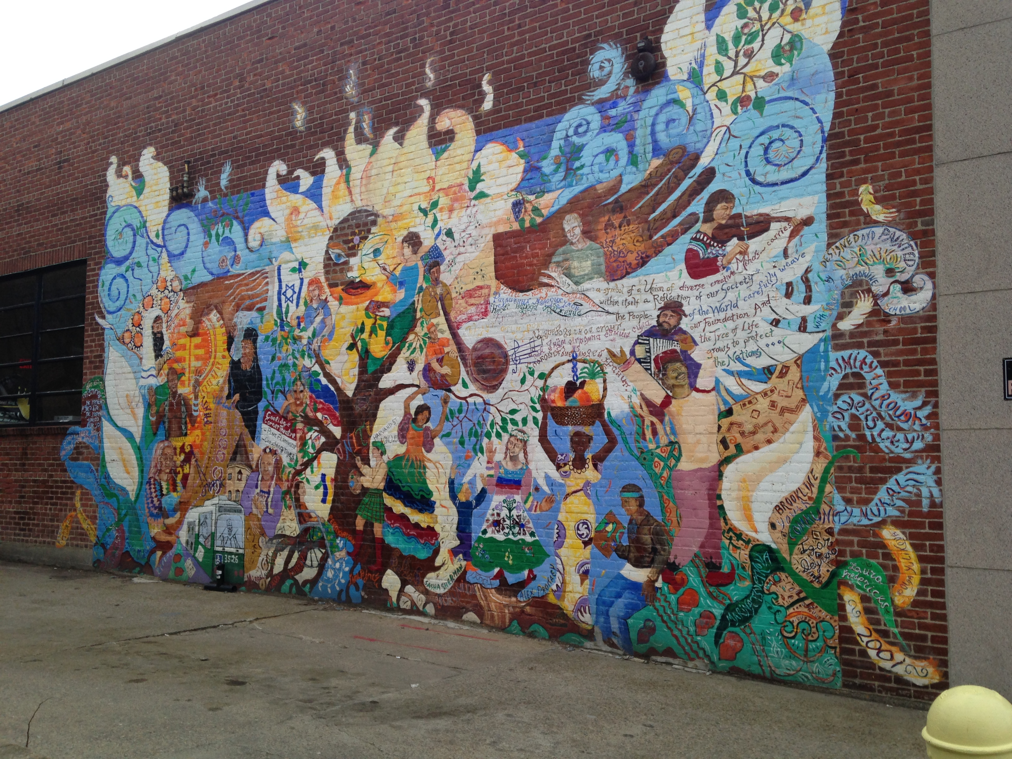
The synagogue in itself is enough to warrant the strong existence of a Jewish community in the region as Hayden’s The Power of Place states that “Eastern European Jewish neighborhoods, distinctive ethnic building types include synagogues.” Still it was cool to find other aspects that hint at this demographic. The Jewish presence in Coolidge Corner became even more apparent when I noticed a Star of David charm on a young girl’s bracelet while eating at a local restaurant in my site. After looking up the Temple Sinai’s website, I found out that the building took over the Second Unitarian Church in 1944. Similarly in 1933, the Coolidge Corner Theatre took over the Beacon Universalist Church, another unitarian-esque church. The movement away from universalist unitarianism beliefs is strange, and I don’t know if it ties into a larger national trend. However, it is evident that as the streetcar brought more business and a diverse mix of socioeconomic classes and ethnic groups to the area, a Jewish community developed in Brookline.
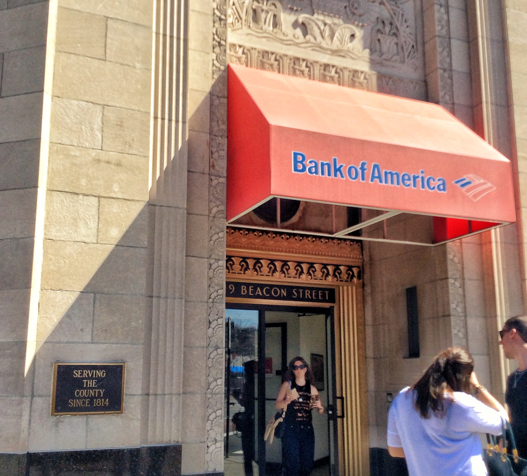
While researching for the trends paper, I found one incongruous artifact that still remains a point of confusion. The plaque next to the Bank of America that sits on the intersection of Coolidge Corner states “Serving the county since 1814.” The building that the Bank of America now occupies used to be the Boulevard Trust Company. This building’s footprint appears on a G.W. Bromley and Co. atlas map as early as 1907, but not on the map from 1900. The plaque is clearly not referring to the building itself, and instead can only be referring to a small branch of the bank’s extensive merger history. The sign very much implies a longstanding relationship of reliability and trust, but is actually a somewhat misleading appeal.
April 19, 2014 - Entry 10
When I revisited my site I saw that the last songle family dwelling that had been in the 1969 map had been paved into a parking lot. Hayden's The Power of Place says that a place should be considered a place even "if only to register the importance of loss and explain it has been damaged by careless development." The parking lot has remnants of the dwelling that used to occupy the space in the form of trees. These trees are the only tangible memory left of Coolidge Corner's rural residential identity. Hayden's idea of place reminded me of Pierra Nora's term lieux de mémoire, places of memory. In a similar stance to Hayden, Nora places emphasis and worth into personal accounts (memory) as opposed to historical criticisms and retellings (history). Just as Hayden believes first hand accounts can help enlighten the territorial history and the racial/ethnic/age/gender boundaries in a city, Nora believes that the memories of individuals are more accurate than historical ones. The second visit to Coolidge Corner also revealed a less glamorous side to a major commercial area of Brookline. A tall brick wall separates the apartments from the alley behind the storefronts on Harvard Street. On the other side of this wall now lies a run down, boarded up building which used to be (appearing on maps as early as 1913) a garage. Adjacent is an auto repair shop that occupies a warehouse with some bashed-in windows and a general abandoned appearance. An auto repair facility has occupied this spot since 1927, but at first glance, one would guess the building was no longer in use. This occupies the area behind the standard commercial thread of Coolidge Corner and the inherent residential nature of the site. It's interesting how things like the S. S. Price store, the bank, and the auto repair store remain the sites of their respective 21st century counterparts.
April 12, 2014 - Entry 9
One obvious artifact that is often mentioned in writings about Coolidge Corner is the S. S. Pierce Building. This building has a cylindrical tower that comes to a point and patterns that in a previous journal I have described as a barn. I originally questioned what this building could have been in the past because it is currently occupied by a Walgreens. The building's footprint shows up on maps as early as 1897. The building faces the intersection that lies at the heart of Coolidge Corner, and its white, smooth material in addition to the large clock face on the tower make the building stand apart as important. The S. S. Price Building is in the location of the original Coolidge Brothers Store and has always had a commercial purpose. In a similar way, the opposite corner currently houses a Bank of America. The building greatly differs in material and style, but it still exudes an air of importance, towering over the intersection with an American flag on its roof. This structure was originally the Boulevard Trust Company of Brookline and first shows up on a map from 1913. These two buildings are found in the same place as they were a hundred years ago and are under the same uses, one a bank, the other a store. However, these buildings and their original occupants represent the site's roots of a small town with small businesses. Instead of the local companies and owners of the early 20th century, the current occupants are mega chain franchises. Following this trend along Harvard and Beacon Street's stores are the presence of a Starbucks, Verizon Wireless, The Body Shop, and Dunkin Donuts--each stores that can be found across the country. The last single family dwelling that had remained in my site in the 1969 map has been torn down and paved into a parking lot. In the parking lot there are three trees that are very large in diameter and stand apart from other trees in the space. The placement of these trees is indicative of the presence of the house forty years ago. While I was photographing the site, a woman said that it had happened recently and is the result of a single company buying up three lots nearby. According to her, the company is planning to develop and build on the land, and there will be more change to come.
April 5, 2014 - Entry 8
Kenneth Jackson's Crabgrass Frontier has been a great read, especially in the context of Brookline (which is referenced a lot in the book). It's weird how the American city developed differently than those elsewhere, most notably the difference in classes that live in the area outside major cities. Recently in my history class (Cities in the Middle East), we've discussed how poorer individuals are forced to live on the outskirts of Cairo in slums that surround the wealthier inner city regions. American cities have become reversed, with more affluent families leaving the city and all of its troubles. Jackson lists the noise, pollution, and high population densities, as push factors for leaving the city. The suburbanization of America (including the town of Brookline) sprouted from a desire to escape the city and workplace and to relax in the rural regions of the country. It's ironic that as the dream of a detached home with more space became more accessible to the average American (as transportation technology advanced and became less expensive), the reality of suburbs grew further from their original ideal. Jackson wrote how the original wealthy suburbanites noted how increased accessibility and movement into neighboring towns caused the suburbs to lose their initial appeal. He explained how these people sometimes even moved further outward into more rural regions. Suburbs, once thought to be a balanced union of nature and city, became increasingly subdivided, populated, and commercialized. Brookline, more specifically, morphed into an incredibly affluent and desirable town, with many new families settling in the early 20th century. Though the city developed as a primarily residential space, Coolidge Corner (along with Brookline Village) took a distinctly commercialized path, gaining stores and flats as opposed to single family dwellings.
March 22, 2014 - Entry 7
The earliest map of Coolidge Corner I’ve found thus far is from 1874; the region began as a primarily residential center. This map reveals that single owners had possession of large lots that typically housed one or two small buildings surrounded by a lot of vacant space. These are uniform for every street within my site.
The next map, of the area in 1897, showed the most drastic change regarding the grid of the site: widening Beacon Street, getting rid of the part of Pleasant Street that reached south of Beacon Street, introducing John Street that connects Pleasant Street to Green Street. Other than these changes that occur between 1874 and 1897, no other changes to the layout were done (except for the later naming of an existing street). The widening of Beacon Street created a hierarchy that would later transform it into a “main” street, where shops and public transportation would naturally take root.
Transitioning to 1913 shows the introduction of institutional land use. Two churches, including the Beacon Universalist Church, and buildings for the Trustees of Tufts College began to pop up along Beacon and Harvard Street. Residential buildings started to shift inward behind these two main streets. Properties also begin to divide into smaller lots; for example, one building on Green Street shows three divisions of ownership.
Moving to 1927 doesn’t reveal too many changes, and the next map I have found is in 1957. I’m going to try to find a map of the in between because 1933 marked the introduction of one pivotal building to the community. The Coolidge Corner Theatre, when researching Coolidge Corner, consistently comes up first and foremost and has been a longstanding symbol of the neighborhood. According to the theatre’s website, the movie theatre took the place of Beacon Universalist Church (formed in 1909) in 1933. The theatre’s website seems to attribute much of the growth to the theatre itself, so hopefully some maps can shine some light on the legitimacy of this claim.
Regardless, the 1957 map shows a huge transition in the direction of a commercial center. Flats and single family residences have been pushed to the smaller streets: John, Green, and Pleasant. Meanwhile, the corners of the Harvard Street-Beacon Street intersection have been divided up into stores and restaurants. This mirrors Warner’s trend stated in Mapping Boston of the time after the Great Depression in the 20th century, though I suspect on a smaller scale since Brookline is quite removed from the city.
I am still having trouble finding transportation information, but Mapping Boston begins to mention the T lines and their advancements in funding in the mid 1900s; this is also in sync with the boom of stores in Coolidge Corner.
March 15, 2014 - Entry 6
My group studied the middle western region of the class site, bounded by Washington Street, Columbia Street, Main Street, and Windsor Street. Since 1873, this area has been dominated by homes. This aspect has not changed in the past hundred years; looking at the 1970 map and each in between shows that the land use has been primarily residential. Although this remains true, one distinct pattern emerged in our findings. Between 1873 and 1930, the properties continued to divide into smaller lots. The land became more dense in buildings and people, and the bare areas filled with new residences. For example, in 1873 Mrs. Susan Fiske owned half of entire clump of land bounded by Main Street, Cherry Street and School Street. However in 1903, her land was cut in half, and this half was split in two as well (half referred to as “The Fiske” and the other half titled “Grace M. Fiske”). This transition also showed the introduction of brick buildings. A few Main Street buildings that were once framed housing in 1873, became brick buildings by 1903, including “The Fiske.” People still owned big strips of property, and this did not change much between 1903 and 1916. Some of the lots changed in orientation, but most kept their size and owners. The jump to 1930 introduced more brick buildings which included nearly all of Main Street, half of Windsor Street, and a single building on Columbia Street. The site at this point is very dense with very few empty areas and very small properties each with different owners; only a few large lots with a single owner remain. A new company, J. W. Greer, has stepped foot onto the top right corner of the boundaries. The transition between 1930 and 1970 is by far the most drastic. Nearly half the properties have been removed, replaced by parking lots and playgrounds. Parking lots have been added to every block and are the product of generally four to eight previous properties. Many of the residential properties are now duplexes or flats. Also, the corner company that used to be J. W. Greer is now a Polaroid Company Warehouse. All in all, the area became a lot less congested in the years between 1930 and 1970.
March 8, 2014 - Entry 5
Source: Photo taken April 2014 by Baily Zuniga.
Source: Photo taken April 2014 by Baily Zuniga.
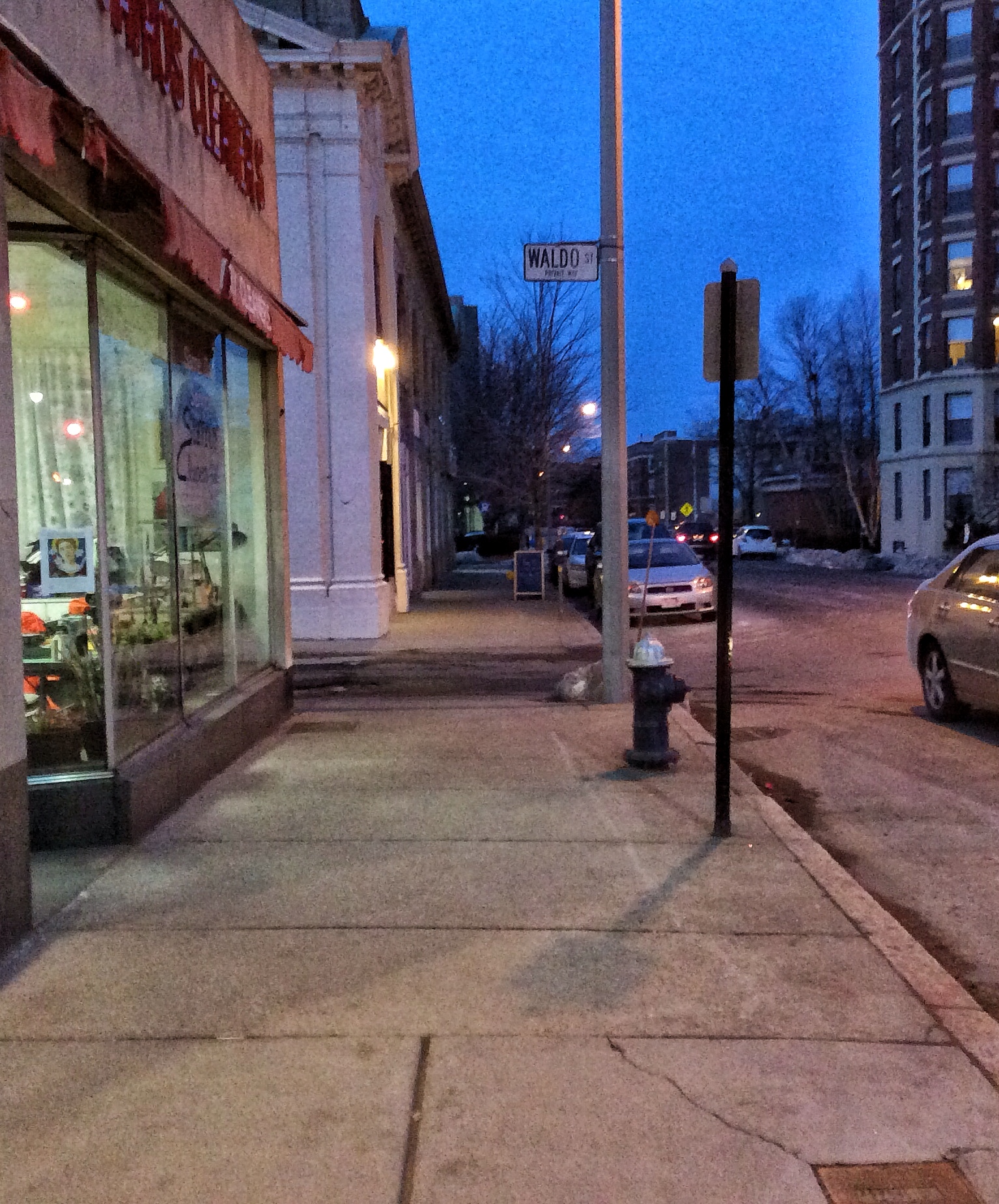
The boundaries of my site contain a wide range of plant life, specifically in the form of trees. There are the trees along Harvard Street which are planted in roughly 3 feet by 4 feet patches of soil. Their trunks are much smaller in diameter when compared to the trees on Beacon Street which are allotted more than twice the amount of space. Some of the Beacon Street trees also have a miniature, decorative wireframe fence as well as a raised curb surrounding the soil plot; whereas, the Harvard Street trees are in soil that is flush with the sidewalk and exposed on all four sides. The Beacon trees are also the only things inhabiting the region of soil, as opposed to the Harvard ones which are very carelessly placed next to street lamps and various signs. Still both of these streets are heavy with foot and car traffic and are centers for commercial activity. Contrastingly, Pleasant Street and Waldo Street, areas that are not typically busy or crowded with shops or people, are left barren. These streets were evidently skipped when planting the homogenous brand of trees in the livelier parts of Coolidge Corner. As explained in The Granite Garden, trees and other plants have become a heavily aesthetic and very expensive inclusion in a city. This is clear in my site where trees were intentionally added to the more popular areas and not to the remote parts. The site also supports The Granite Garden’s explanation that tree species experience trends in styling cities. Still, John Street, home of many residential buildings, is the most successful region regarding plant life. Along with the larger areas set aside for trees, individual apartments also include smaller bushes and plants lining the doorways. These trees by far fair more successful than the trees lining the boulevards of the shops. They reach infinitely greater heights and contain many branches. The trees are not the same species as the others, which leads me to believe they were planted prior to the desire to make a fashionable statement.
Source: Photo taken April 2014 by Baily Zuniga.
March 1, 2014 - Entry 4
As I gaze out the window from a Starbucks in my site, I can already begin to see some natural processes present in the city. The main road of Coolidge Corner exhibits many signs of distress including raveling and cracking as described in Elkins’ “How to look at pavement” chapter of the reading. Most of the cracked layers rest on the bike lane division exposing lose gravel and creating large holes in the asphalt. This road, Harvard Street, is clearly a primary path of travel and a zone for much stop and go traffic due to pedestrian crosswalks. This traffic could be the cause for some of the shoving that is present in the street’s center.
The trees on the boulevard rest in small patches of soil, rectangular strips roughly two by four feet. The west-facing trees on Harvard Street are much smaller than their east-facing counterparts. The bark looks a bit grungier and the tree branches appear to have been chopped off at a much lower height than the ones on the opposite side of the street. Street signs on this side of the street seem to be the reason for the removal of lower branches. Also, their clustering branches are much shorter and thinner whereas the other trees have long, wide-reaching limbs. These trees seem to be the same species with similar color and branching patterns, however, when you cross over Beacon Street, traveling south on Harvard, the bark of the trees become much darker; the trees seem older, taller, and more densely placed. I’ll have to take a closer look at these ones. From where I’m sitting an obvious difference and possible cause might be the size of the surrounding buildings. The darker trees are surrounded by much shorter structures than the lighter trees which could account for more sunlight availability.
So far I've found The Granite Garden to be very interesting. It's pointed out some interesting things that I haven't considered or taken much time to think about, like how the city and nature are viewed as separate spheres when in reality they are one in the same. The intentional "inclusion" of nature in the city (through the addition of trees and other green areas, etc. as seen in Coolidge Corner) is funny when you think about how nature is always there and is actually everywhere.
February 22, 2014 - Entry 3
I found the James Elkins’ How to Use Your Eyes excerpts (especially the preface) mesmerizing and beautiful. I’ve already been one who naturally notices seemingly insignificant details in day to day life, but this makes me want to consciously focus on the world differently and more actively. During my last visit to Coolidge Corner, I tried to question things but primarily focused on bigger ideas like why there is no uniformity in any of the buildings or why every corner business is angled to face the center of the intersection. I do remember seeing distressed parts of some store fronts, places where the colorful paint had long chipped off. One of these places in particular looked completely abandoned, but incongruously had a store sign which made me wonder otherwise. For a Saturday night, the site was rather vacant, considering the amount of commercial businesses that line the streets. The hours for the area were also a surprising ten or eleven for Starbucks and Dunkin Donuts, compared to the Cambridge and Boston equivalents which close at nine or eight. I spoke to one of the workers at Starbucks who said that it doesn’t get too busy and they typically only have two employees staffed. Thus far it seems like Coolidge Corner is trying to have a night life or at least a “happening scene” but is not quite succeeding. When I return, I reckon new features will come into view.
The reading also focused specifically on a culvert in Tarrant County, Texas which is the county where I reside. When I took the written part of the road test to get my license, I remember missing a “identify this street sign” question; the sign was a vertically oriented skinny rectangle with black and yellow diagonal lines. I remember passing the test still entirely unaware of that signs existence in real life. Once I began driving, however, I saw that sign everywhere and realized that it always denoted a bridge or rather, a culvert. The signs are found in front of the mini rails that Elkins mentioned in the reading and immediately came to mind. After passing so many of these structures, it’s weirdly satisfying to finally know what they are called.
February 15, 2014 - Entry 2
When asked to pick a site for further study in the Boston area, I had the trouble of narrowing down all the places I have enjoyed visiting to a single location. I knew for certain that wherever the place it had to be accessible by the T Subway system. I find the idea of mass public transportation really intriguing, probably because the concept and practice is foreign to me, a native Texas suburbanite. Still for this particular assignment I wanted to explore how a suburb was integrated into the major city of Boston through means of transit services, to see how the development of a town in greater Boston responded to the introduction of the T rails. The Green Line is particularly interesting because it primarily connects the western suburbs to the main city (as opposed to connecting smaller neighborhoods of the city itself).
With this in mind, I knew I wanted to delve further into the city of Brookline. There are some nice commercial areas of this city, but I reckon that they weren’t always as developed. Coolidge Corner in particular caught my eye because it had been a place I visited prior to applying to MIT. My parents and I ate a hibachi restaurant in the area in the summer of 2012, but upon returning to the same restaurant in the fall of 2013, the area felt like an entirely different place. During my first visit I had learned that the place had only recently opened, and our chef was a man from Texas no less. The food was delicious and was a very memorable experience that reminds me of my first trip to the northeast (as well as MIT). My boundaries for Coolidge Corner therefore had to include not only the T-stop but also this restaurant. There is also a movie theatre nearby which catches my interest, as well as a set of residential streets that form a very acute angled intersection—all of which must be included. From these rules I have formed my boundaries and as I finish writing this I am setting off to the Hynes stop in the Back Bay to take the T to my site.
February 8, 2014 - Entry 1
Source:Photos taken and arranged by Baily Zuniga.
Spending the last six months in the Boston area has been amazing, and I think I finally realize why it has been so different. I know that I’m from the Southwest and that the Northeast is about as far as one can travel on the spectrum of American culture, but the cities themselves are drastically dissimilar. I grew up in two different suburbs in the DFW area, one directly north of Dallas and the other north of Fort Worth. Most traveling is done by means of personal automobiles and expansive highways, and there is very few mass transit systems in the whole metroplex (they exist but they are more of an attraction rather than part of one’s daily commute). Anyone living or passing through cities in Texas can see that they are geared for cars. Street signs are big and easily spotted from far away and are almost always located above the traffic lights; there are often “next intersection” signs posted prior to busy, popular intersections to give drivers extra time to merge into the correct lanes. This is completely different from Boston, which either has the tiny street signs that are staked into the ground or just no signage at all, making it nearly impossible to know where one is at any given time. Everything is also spread out in the DFW metroplex and locations are typically referred to by individual city names as opposed to general areas like the Back Bay or Copley Square/Harvard Square/Central Square/Kendall Square/Inman Square—as you can see this idea of “squares” is completely foreign to me. One could say Fort Worth and Dallas have some of those areas, for instance there’s Victory Park and the Stockyards, but those are closer to being specific places and not districts. When my family came to Boston, we were baffled by the shear number of people out on the streets. They were biking, walking dogs, running, sailing, rowing, strolling, getting on and off of buses, coming out of the subways, and it was just really bizarre. I later read something that deemed Boston as America’s walking city which is a perfect description especially compared to Southern cities. I have continually questioned why I had never walked around (to the same extent that I have walked around Boston) cities back home. In other words, whenever I went exploring in Texas, it was always via car. So when this week’s reading included how Victor Gruen in 1956 had tailored Fort Worth to have a “pedestrian-free core” everything began to make sense. It shows how dramatic a role that past city planning plays in one’s experience in cities today which sounds very “duh” but is still crazy to think about.