Growing up in Washington DC, where Chinatown consisted of just a small number of restaurants, when I came to Boston, I assumed its Chinatown must be similar. My friends and I would get off the Chinatown T, hustle down Beach Street with its bustling restaurants and famous Chinatown gate, grab bubble tea and pastries, and head back to MIT. But I could not be more wrong. One day, while browsing around Chinatown using Google Maps, I saw homes, schools, churches, parks, and even Tufts University buildings. I began to wonder: What made Boston’s Chinatown a bustling Chinese community such a small area? Who settled there before the Chinese? And when did Tufts University’s buildings integrate themselves inside? Suddenly curious about its immigration history and its role as an epitome district, its diversity of land uses, and its juxtapositions between the old and the new, I decided to study Chinatown.
My site begins at the intersection of Essex Street and Surface Road, at the north edge of Chinatown Park. Traveling south along Surface Road and the park, we pass the Chinatown gate and main street (Beach Street), the site of most of its restaurants and tourist sites. Keep heading south and cross Kneeland Street, and the park becomes a formerly grassy area that is now ridden with construction. West of the construction site is a residential area of old, brick homes and narrow alleys. As we continue south on Surface, we reach Curve Street and Marginal Road, the south border of my site and home to a Chinese school, a childcare center, and a church. Then, heading back north on Harrison Avenue, the west border of my site, towards Essex Street, the north border, we pass an eclectic mix of homes, scattered restaurants, doctor offices, Tufts University buildings, and parking lots. I chose these borders to encompass the varied land uses and depict the contrast between the busy tourist district and the quiet residential neighborhoods.
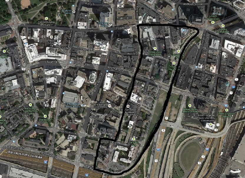 Figure 1: Map of my site, which is outlined in black. Google Maps (2014). Retrieved February 16, 2014 from: https://maps.google.com/
My site stands out to me as one of Boston’s epitome districts, areas where, according to Clay (1980), “one may observe formal and informal rituals, symbolic activities” and serves as “[t]he beginning point” that offers clues to the site’s current nature and history (p. 39). Naturally, such a beginning point is Chinatown Park and the famous Chinatown gate, where residents congregate for chess, gossip, and other recreational activities. Yet this gate not only marks the entrance to Chinatown, but as an epitome district, also guides us to the eclectic land uses that encompass almost every resource a community needs: homes, churches, schools, restaurants and shops, office buildings, research buildings, and green space. I plan to investigate how the community formed and fit so many land uses into a mere ten blocks. Moreover, the classic gate of Chinese architectural style is juxtaposed with old Western-style brick homes and new glass buildings, such as an office of State Street Corporation, reminding us that this area was not always Chinatown, and continues to be changed by outside development. Thus, I am also interested in Chinatown’s immigration history: who settled here before, and how the Chinese community has changed or not changed the area.
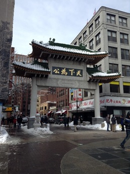 Figure 2: Chinatown’s Gate and Beach Street. Image by Author, 2-16-2014
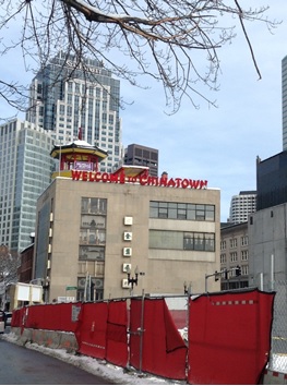 Figure 3: Contrast between an old, symbolic building of Chinatown and the new offices such as that of State Street Corporation. Image by Author, 2-16-2014
Finally, the site is thriving with breaks, “abrupt visible switch[es] in the direction and/or design of streets” and anomalies that, according to Clay (1980), may offer “clues to history as well as to current events” (p. 42). One break occurs at Beach Street, where diagonal streets merge with straight grid patterns. Beach Street is the liveliest street, home to the restaurants and tourist areas, leading me to wonder if Beach Street also has a historical significance, perhaps a place where different communities intersect into one busy town center. Another anomaly that I am curious about is the contrast between formerly barren land that is now a construction site and the residential area that it borders. Why was the formerly barren land not settled by Chinese residents, and why is it a site of construction now? I also want to investigate the contrast between building materials - brick buildings next to concrete buildings - which may suggest that the buildings were created during different periods by different groups of settlers. Finally, the contrast between old buildings with cracking walls and new, larger buildings of glass makes me wonder how new development has changed the area, and the direction of future development.
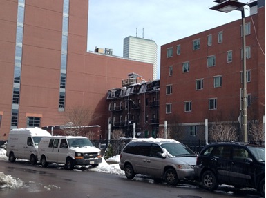 Figure 4: An old brick building sandwiched by two newer buildings. The new building to the left is Tufts University’s Center for Biomedical and Nutrition Sciences. Image by Author, 2-16-2014
Chinatown is an eclectic and thriving clash of old and new and Chinese and Western cultures. It is currently home for a bustling Chinese community, but also embeds centuries of immigration history of different settlers. Today, it faces the influences of new development from corporations, construction, and universities both in and around the community. By studying the site this semester, I hope to uncover more about its past and its direction of change going forward.
Bibliography:
Clay, Grady. (1980). Close-Up: How to Read the American City. Chicago, IL: The University of Chicago Press.