Over a period of time, a site can accumulate layers of changes, such as those pertaining to politics, economy, society, and culture. In addition to these layers, studying the various scales between locality and internationality can give a more holistic reading of the area. In the case of my site, it would seem that early industrialization led to a rather well-defined development of land usage, which in turn encouraged expansion of economy to the international scale. Yet, when these industrial processes were rendered fairly obsolete, the site shifted inwards to generate a more community-oriented scheme. Ultimately, the placement of infrastructure guided land use, economic development, and international communications through transportation and exportation of goods and technology. However, the mid-20th century presented a pivotal shift, prioritizing locality and a strong social community.
Infrastructure: The Frame of Connectivity
The first historical layer takes shape through the establishment of infrastructure on and around the site, and the implications associated with it. Specifically, the Broad Canal extends into my site, ending at the modern-day Cardinal Medieros Street. Here, the presence of the “Boston Rolling Mill” can be seen.
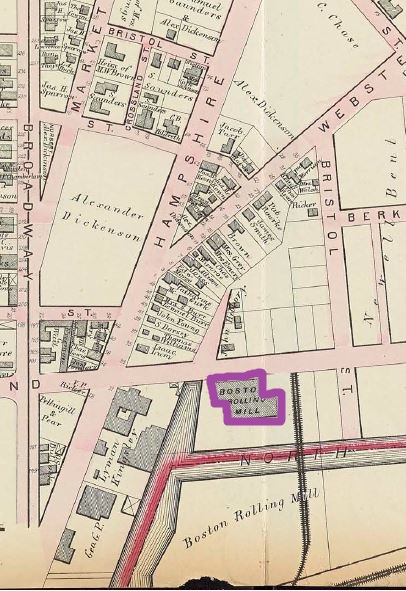
Figure 1: Hopkins, Griffeth Morgan. Atlas of the city of Cambridge, Middlesex Co. Boston Rolling Mill outlined in purple. The proximity of the site to the “North Canal” and the Boston/Albany Railroad suggests the potential to form an industrialized zone. For the remainder of the maps, unless otherwise noted, Broadway Street is at the bottom of the map.
Streetcar lines along Broadway, a fairly new development compared to the rest of the streets in the area, indicate a need for public transportation. Broadway connected East Cambridge with Harvard, so it’s no great surprise that a major road would develop a more efficient mode of transportation first. The implication of the streetcar most likely is associated with real estate development. A line that leads into a reasonably undeveloped and partially unclaimed site can be explained by Kenneth Jackson’s Crabgrass Frontier, “The cable car was cleaner…quieter…and more powerful. It was also swifter than animal-powered locomotion…Because of these advantages, the cable car encouraged real-estate development” (104). With the presence of the streetcar, more people may be guided into the site for prospective investment. With this in mind, the appeal of the streetcar resulted in heavy investment into what would become the site’s dense residential zone, rendering it crucial to the site’s land usage development.
Social Divisions and Land Usage
Layered on the early composition of infrastructure are the division of land and the social structure embedded within that division. As hypothesized by the infrastructure conditions, the foundation of industry is prominent with the establishment of the Iron Foundry, Woven Rubber Hose, and the neighboring soap manufacturers. This heavy industry designation will remain throughout the years for a number of possible reasons. Firstly, the necessity of industrial sites was needed in conjunction with the development of Cambridge. For example, the growth of streetcar lines and railroad tracks require high quantities of iron, for which the iron foundry would be able to provide. Some buildings off of my site were industrialized in this area, such as Bridge Works, coal yard, lumber yard, and iron works support this idea of construction development. Secondly, Boston may have exported some of its industrial processes as the residential area of the Back Bay developed. This phenomenon is described in Crabgrass Frontier as the following: “Industry…began moving from urban cores even at the height of the age of steam power. The high price and scarcity of land in central areas, coupled with municipal regulations and taxes were important encouragements to disperse” (Jackson, 183). The presence of companies that identify with the Boston side of the river such as the Boston Rubber Company and Boston Bridge Works support this idea. The proximity that these companies have to the Broad Canal would facilitate the transportation of goods across the Charles River, effectively completing the outsourcing scheme.
In terms of female land ownership, two names in particular stand out. Alex Dickenson owned mostly undeveloped land which would become the Boston Rubber Company. Slightly outside of my site lies Dickinson Street, which could’ve been named for the same family name. Mrs. Alex Dickenson, held a claim to the small plot of land between Broadway and Hampshire, of which was already fully developed as a machine shop. It seems that the Dickenson’s had a considerable amount of influence, so perhaps it is not so surprising that a female constituent of the family should also own land. A similar case can be said for the Sanders family. However, in this case, the female landowning name appears more than its male counterpart. It seems that the Sanders name is one that carries a lot of weight, but perhaps the land simply flows from female owners to male inheritors.
There is certainly diversity amongst the family names on the site. There are no governmental claims to land, so it would seem that the industry was perpetuated mostly by private investors. In terms of residential areas, the presence of female landowners and single-family estates could have set a precedence of private, relatively wealthy landowners who passed down land to ensure the strength of the family name. We will see that the presence of the wealthy estates was maintained throughout the rest of the 19th century, and half of the 20th century.
Between the industrial buildings surrounding the Broad Canal and Boston/Albany Railroad, and the residential buildings predominantly structured as single-family homes, there is no clear sort of intermediate zone between the two areas, by way of either small commercial buildings or even tenant buildings. Most of these kinds of buildings are found within a neat boundary in the residential blocks and industrial blocks, respectively. In the latter case, perhaps the factories have subsidized housing for the workers, allowing the residential area to develop around it. The clear distinction between the residential and industrial blocks could potentially form a sort of social barrier between factory workers and the private estates, or perhaps is simply in a stage of early development that doesn’t require small businesses.
Economic Extensions
In terms of economic advancements, the main theme of the early 20th century seems to be centered on movement and external connections. The foundation set in the infrastructural scheme and land divisions will help to establish an economy that can truly expand beyond the limits of the site. As mentioned before, the presence of the main industrial blocks containing the rubber company and the foundry will create an opportunity for both the surrounding areas and the larger international economy. Just on the other side of the Boston/Albany Railroad is the American Rubber Company. Taken in conjunction with the Boston Rubber Company, the Broad Canal, and the railroad itself, the potential of this product to reach an international scale is quite high. The iron foundry could serve a similar purpose. However, instead of an intercontinental enterprise, the foundry was most likely used for development of local transportation, through streetcar and railroad lines.
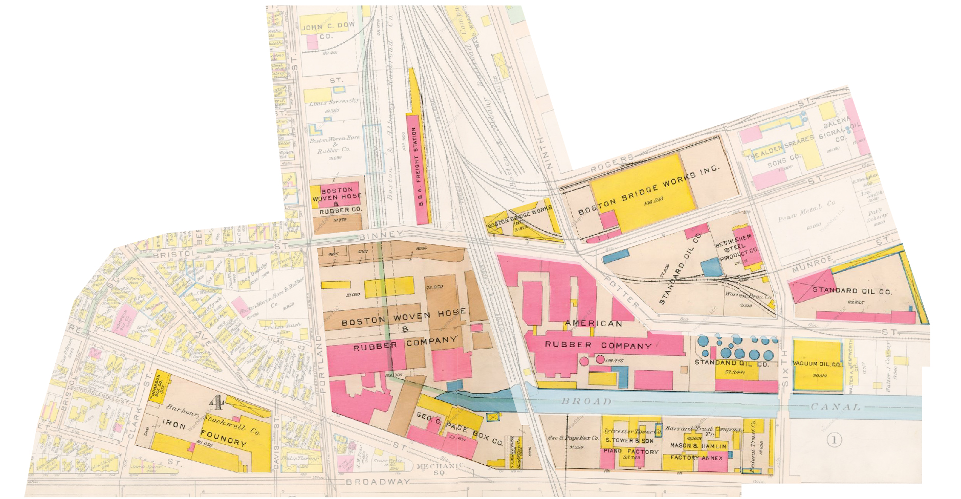 Figure 2: G.W. Bromley and Co. Atlas of the City of Cambridge, Massachusetts. 1916.
The expansion of industry beyond my site shows the proliferation of economy-driven programs along the Broad Canal. Highlighted are companies that were possibly using the railroad as a means of international transportation, which include the Iron Foundry, Boston Woven Hose and Rubber Company, Standard Oil Company, and American Rubber Company.
Figure 2: G.W. Bromley and Co. Atlas of the City of Cambridge, Massachusetts. 1916.
The expansion of industry beyond my site shows the proliferation of economy-driven programs along the Broad Canal. Highlighted are companies that were possibly using the railroad as a means of international transportation, which include the Iron Foundry, Boston Woven Hose and Rubber Company, Standard Oil Company, and American Rubber Company.
Moving into the 1930s brought about an expansion and consolidation of the industrial sector on the site. The rubber company grew to the other side of Portland Street, and the tenant housing was erased from the east Portland/Hampshire block. However, the most significant change to the site was the presence of auto repair shops and filling stations, which have begun to infiltrate the residential zone. This seems to coincide with the availability of the automobile to an ever-increasing percentage of consumers.
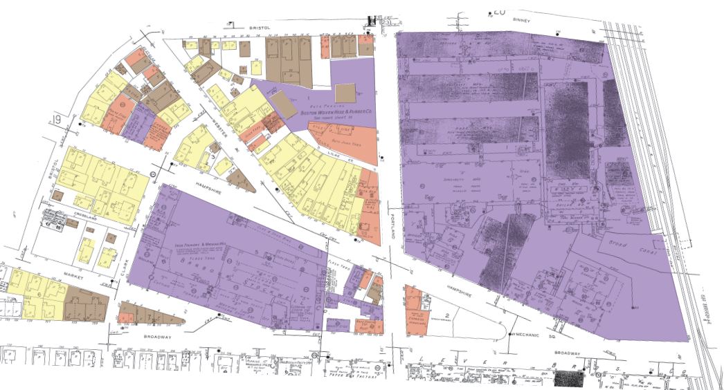 Figure 3: Sanborn Map Co. Insurance Maps of Cambridge, Mass. 1934
Retail begins to form an intermediate zone between the industrial and residential areas. Single family homes begin to convert to auto stores in order to meet the demand of repairs and fuel.
Figure 3: Sanborn Map Co. Insurance Maps of Cambridge, Mass. 1934
Retail begins to form an intermediate zone between the industrial and residential areas. Single family homes begin to convert to auto stores in order to meet the demand of repairs and fuel.
The placement of the shops also seems to begin a division of the industrial and residential areas, becoming a sort of intermediate zone between the two. What seems even more significant is the establishment of both auto junkyards and a garage. This seems to signify two things in addition to the growing usage of the automobile; firstly, people are consuming vehicles at a rate that requires replacement. Secondly, the garage implies transportation from beyond the local area. As noted in Crabgrass Frontier, “They [trucks] were not generally available until 1909, but their impact was quick. K.H. Schaeffer and Elliott D. Sclar have calculated that manufacturing employment in Boston’s inner ring (defined as communities from two to six mile from the Boston Common) grew much faster than those either closer in or farther out between 1909 and 1919” (Jackson, 184). This suggests that the trucking industry has a major impact on the development of the site. The map also states that the garage was capable of holding 10 trucks, most likely suggesting that the movement of goods in and out of the industrial sector now included vehicles.
The transition to the 1970s brought a fairly large development in retail and industrial buildings. While the automobile services remained largely relevant, one of the most intriguing developments was the conversion of the single-family homes to retail buildings. Perhaps this was the beginning of the urban renewal in Cambridge. The residential buildings that were left remained mostly single-family homes, so the families displaced must have relocated elsewhere, perhaps more inland. As noted by Jackson, “The fact that peripheral neighborhoods had then and usually have now the legal status of separate communities has given them the capacity to zone out the poor, to refuse public housing, and to resist the integrative forces of the modern metropolis” (277). If people were not wealthy enough to keep their homes, it seemed inevitable that the economy would possess the valuable space. Throughout most of the 20th century, the economy seemed to be focused on expansion of goods to other parts of the country, as well as an expansion of industrial holdings on the site.
Social Shifts to Locality and Community
While the early development of the site seemed to include only the necessary tools for expansion such as land designation and the strong foundation of infrastructure, the years following the formation period were marked by significant external events, which initialized a focus on community priorities. The first influential change to the site began in the 1930s with the influx of international immigrants into the site. The amount of foreign property owning names has largely increased (in the early years of settlement, the names were mostly Anglo-Saxon). Names like Herreira, Ferreira, Sousa, and Zimmerman litter the site. This change will in fact have a large impact on the political and social decisions moving into the years surrounding World War II.
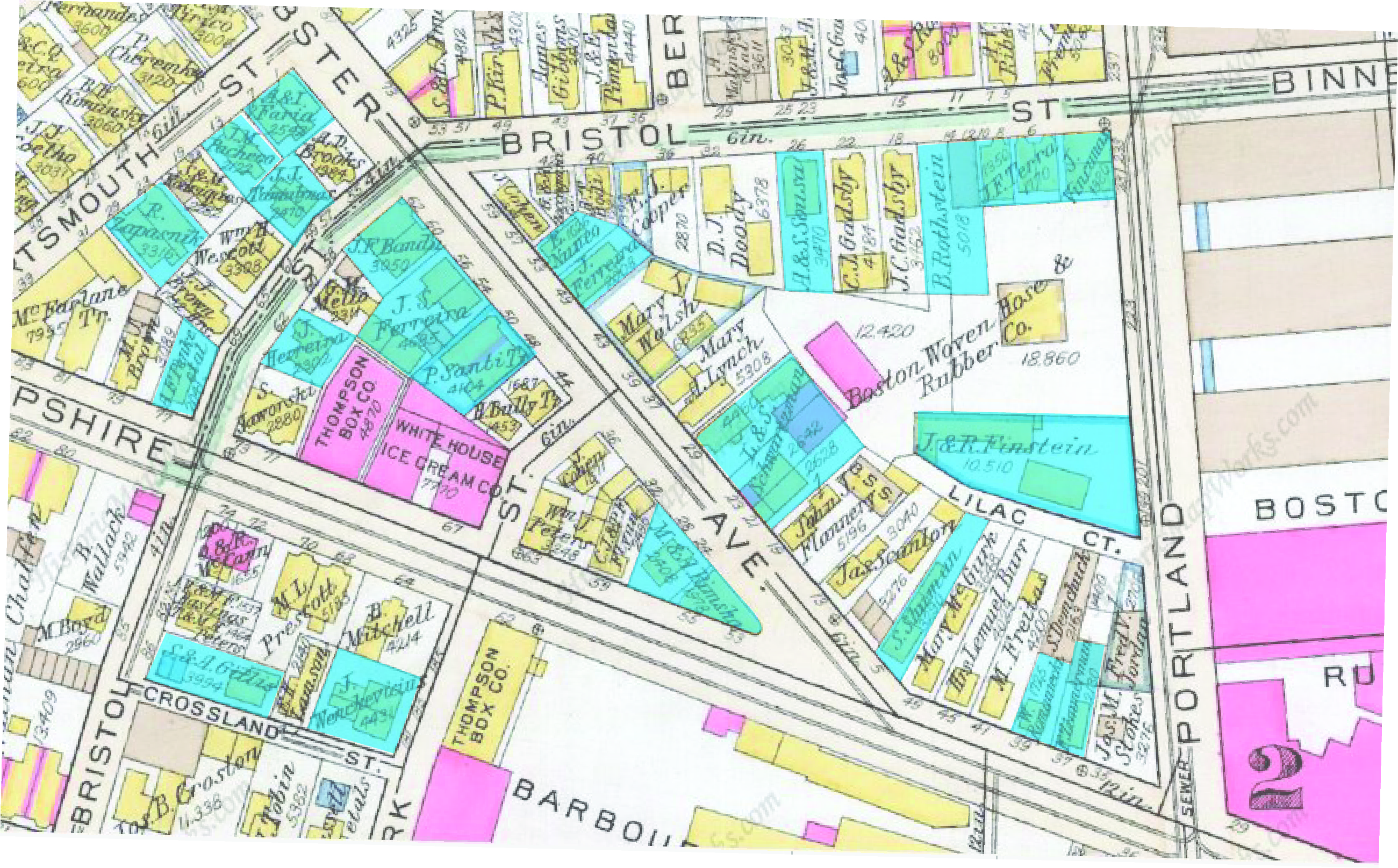 Figure 4: G.W. Bromley & Co. Atlas of the City of Cambridge, Massachusetts. 1934.
The presence of a variety of racial family names proliferates during the 1930s. Names seeming to be of a descent other than Anglo-Saxon are marked in blue. The frame of focus is on the most densely residential area in the site.
Figure 4: G.W. Bromley & Co. Atlas of the City of Cambridge, Massachusetts. 1934.
The presence of a variety of racial family names proliferates during the 1930s. Names seeming to be of a descent other than Anglo-Saxon are marked in blue. The frame of focus is on the most densely residential area in the site.
The history of the Dante Aligheri Cultural Center, formally present on my site since the 1980s, is an example of such a political and societal disruption. The center had an influential presence in Cambridge in 1911, but during the wartime period, international communities, especially those celebrating the culture of the enemy, were forced to disband due to the “un-American” nature of their organization. Even in 1961 the organization was on the subversive list, and removed with the help of Ted Kennedy. The fundraising for construction is perhaps the most intriguing part of the history, in terms of political involvement. The mayor of Cambridge himself, Alfred Vellucci, personally started a fundraiser for the construction of the site, and was integral to the requisition of the current site (1). The cooperation and willingness of the government to construct such a community-oriented building certainly shows the eagerness to begin a new societal era based on local organizations.
The case of the Italian Cultural center is a bit of an anomaly. It remains the only institutional building on the site, as well as the only building that had received some sort of direct political influence. However, the pressures of efficiency, urban renewal and the MIT institution surrounded the site in the 1980s, leading to the disappearance of the Broad Canal and the consolidation of industry on the site.
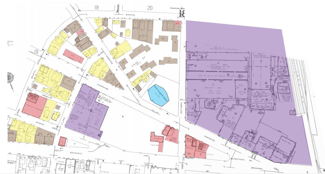 Figure 5: Sanborn Map Co. Insurance Maps of Cambridge, Mass. 1988.
Urban renewal sweeps over the site, eliminating ancient industrial presences and allowing for more consolidation of housing units (note the condominium complex above the Italian Cultural Center). Comparing this map with the 1934 Sanborn map, there is quite a lot of empty white space, suggesting further development.
Figure 5: Sanborn Map Co. Insurance Maps of Cambridge, Mass. 1988.
Urban renewal sweeps over the site, eliminating ancient industrial presences and allowing for more consolidation of housing units (note the condominium complex above the Italian Cultural Center). Comparing this map with the 1934 Sanborn map, there is quite a lot of empty white space, suggesting further development.
Urban renewal swept through Boston in 1960 with the development of Government Center. Conversely, my site was quite slow to develop. The first consequence of land redevelopment in my site was the truncation of the Broad Canal, but there were no immediate consequences.
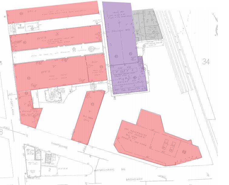 Figure 6: Sanborn Map Co. Insurance Maps of Cambridge, Mass. 1996.
In less than 8 years, the industrial complex has been transformed into a series of office buildings in order to meet the demand of growing companies. The current researching company is Schlumberger-Doll, said to have moved to this site due to the increasing influence and innovations. Frame of the map is around Portland, Hampshire, and the Boston/Albany Railroad.
Figure 6: Sanborn Map Co. Insurance Maps of Cambridge, Mass. 1996.
In less than 8 years, the industrial complex has been transformed into a series of office buildings in order to meet the demand of growing companies. The current researching company is Schlumberger-Doll, said to have moved to this site due to the increasing influence and innovations. Frame of the map is around Portland, Hampshire, and the Boston/Albany Railroad.
However, in more recent years, MIT and urban renewal have taken an enormous toll on my site. The consolidated industrial unit that had been present on my site since its inception has now been filled with offices and laboratories associated with MIT. The building of new types of buildings such as offices and laboratories seems to have ushered in a new age for my site. Instead of mass-produced goods to be shipped across the country, ideas and research are produced for a select few. With the imposing and ever-increasing influence of the institute only a couple of blocks away, the focus of my site has turned to one that looks at the future, one that considers the needs of its community and how it can begin to help those that surround it.
To conclude, my site displays a fascinating series of changes that have built upon each other as time progresses. Starting with the infrastructural foundation of railroad, canal, and streetcar, the site was consequently divided into industrial and residential zones. The industrial zone proved to be a host to significant constituents of both the local and international economy in conjunction with the extension of the railroad. This focus on externalization comes to an end, however, in the mid-20th century due to an influx of immigration and pressure from local governments and institutions. These external factors play a pivotal role in shifting the usage of my site into one that supports the community and local endeavors.
References
Jackson, Kenneth T. Crabgrass Frontier: The Suburbanization of the United States. New York: Oxford UP, 1985. Print.
(Fig. 1) Hopkins, Griffeth Morgan. Part of the Second Ward of Cambridge [map]. 1:200. In: G.M. Hopkins Co. Atlas of the City of Cambridge, Massachusetts. Philadelphia, PA: G.M. Hopkins and Co., 1873. Page 42.
(Fig. 2) Bromley, Walter S. Part of Wards 2, 3, and 4 [map]. 1:100. In: G.W. Bromley and Co. Atlas of the City of Cambridge, Massachusetts. Philadelphia, PA: G.W. Bromley and Co., 1916. Page 13.
(Fig. 3) Sanborn-Perris Map Co. 1:50. In: Sanborn-Perris Map Co. Insurance maps of Cambridge, Mass. New York, NY: Sanborn-Perris Map Company, 1934. Page 21, Page 24. MIT Map Collection (04 April 2015).
(Fig. 4) Bromley, Walter S. Part of Wards 1 and 2 [map]. 1:100. In: G.W. Bromley and Co. Atlas of the City of Cambridge, Massachusetts. Philadelphia, PA: G.W. Bromley and Co., 1930. Page 13.
(Fig. 5) Sanborn-Perris Map Co. 1:50. In: Sanborn-Perris Map Co. Insurance maps of Cambridge, Mass [scan]. New York, NY: Sanborn-Perris Map Company, 1988. Page 21, Page 24. MIT Rotch Library.
(Fig. 6) Sanborn-Perris Map Co. 1:50. In: Sanborn-Perris Map Co. Insurance maps of Cambridge, Mass [scan]. New York, NY: Sanborn-Perris Map Company, 1996. Page 21, Page 24. MIT Rotch Library.