I
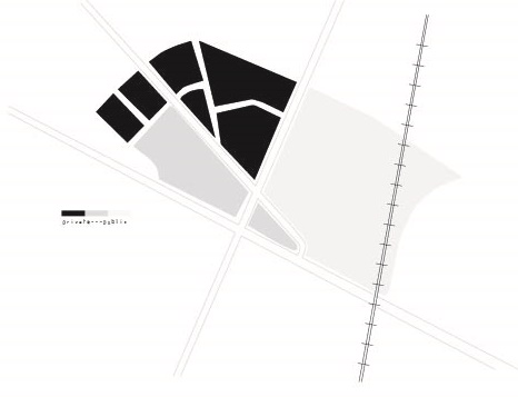 Diagram of public and private blocks in the site
In terms of the reading, something that stood out the most to me was the idea of individual perception. As the city is physically rebuilt and transformed, Grady Clay (quoting from George A. Kelly’s A Theory of Personality: The Psychology of Personal Constructs) says; “each person builds a mental picture of the world, and then proceeds to continually modify, rebuild, and reconstruct it. We do not merely react and respond to the environment; we actively represent it and construe it – and thus build alternative constructions on it” (Close-Up: How to Read the American City, 13). Similar to what I was discussing earlier, it is the obligation of the inhabitants to perceive the world and reconstruct it as it suits their specific needs. The idea of personal interaction and involvement in the development of the city is incredibly powerful, in my opinion.
II
The site that I have chosen is on the periphery of Kendall Square, and is bounded by Galileo Galilei Way, Broadway, and Bristol/Binney Street. Hampshire Street bisects the site as well, ending in an intersection with Broadway. The site is therefore intriguing due partly to the radial composition of the two major roads; Broadway and Hampshire. There doesn’t seem to be anything of obvious importance in terms of a building on the site, so there is the possibility that the road exists to divide Area 4 from Mid-Cambridge, if those neighborhoods were established with different intentions. From the map that I’ve posted below, we see that Hampshire Street existed at an odd angle since at least 1930, which could support this claim. Yet, as Clay says, “Original grids were hardly big enough for growth…At that point, the old railroad grid was abandoned, and beyond the one-mile roads, new streets shifted to follow the national grid…” (47). This would make sense, as the grid of the site is certainly orthogonal to the railroad track, except there doesn’t seem to be any discontinuity beyond the break that is Hampshire Street. The roads beyond are continuously linear. So, I’m not exactly sure what’s going on here.
According to Google Maps, the site technically lies in between Area 4 and Mid-Cambridge, split, as I mentioned before, by Hampshire Street. In the basest of descriptions, Area 4 is a densely populated residential neighborhood, while Mid-Cambridge is a mix of “innovation buildings,” commercial centers, institutional centers, and residential neighborhoods. From my initial site visit, I can deduce that the site has absorbed the culture of both districts, and has utilized them to seemingly beneficial effect.
 .
. Map of grid layout surrounding Broadway and Hampshire streets.
The main structure of my site seems to be focused on a public, community periphery space, while residential blocks are located at the center. Of course, the expanding influence of Kendall square is also at work, as technological influences are imminent in the surrounding community. This is especially present in “Technology Park,” a series of Draper Laboratories that have begun to proliferate along the railroad tracks: a seemingly appropriate juxtaposition of new and old. With this boundary on the south side of the site in place, the western side bounded by Broadway is dominated by small, locally owned restaurants, businesses, and small community parks. Of course, scattered within are mixed-use office/residential buildings, although not particularly prominent. I look forward to studying this relationship between public periphery, and the effect that it has on the community.
III
The main structure of my site seems to be focused on a public, community periphery space, while residential blocks are located at the center. Of course, the expanding influence of Kendall square is also at work, as technological influences are imminent in the surrounding community. This is especially present in “Technology Park,” a series of Draper Laboratories that have begun to proliferate along the railroad tracks: a seemingly appropriate juxtaposition of new and old. With this boundary on the south side of the site in place, the western side bounded by Broadway is dominated by small, locally owned restaurants, businesses, and small community parks. Of course, scattered within are mixed-use office/residential buildings, although not particularly prominent. I look forward to studying this relationship between public periphery, and the effect that it has on the community.
Now that there is a sort of guide to reading detail, it is not sufficient to just consider general patterns. The details are to be used as a specific moment, from which general assumptions can be made, in addition to regarding general patterns such as land use and infrastructure. Relating to my site, I think the only place to start would be a study of tree varieties, considering everything is covered in snow.
IV
The site that I chose not only is interesting for the infrastructural merits, but for the interaction between built and natural processes. An obvious first observation is the implications of the accumulation of snow and ice on the site. In the residential roads such as Lilac Court and Market Street, two lane roads have been reduced to one lane roads due to the accumulation of snow on the sides of the roads. This could be troubling, as these streets often relieve the heavier traffic on Broadway and Hampshire. In addition to snow on the ground, there were a few interesting icicle formations on both the houses and the plants. There was a common pattern that hosted icicles, as seen in the following picture. The low roofs, with insubstantial drainage systems, were not enough to prevent icicles from forming. The houses in this picture are facing south, off of Bristol Street.
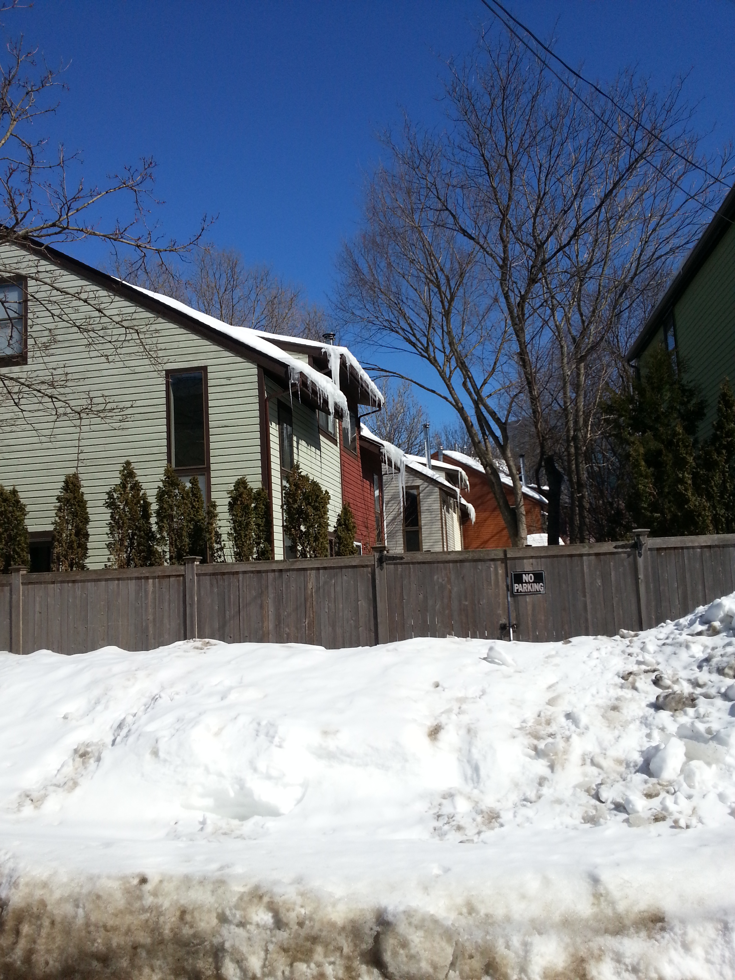 .
. Icicle formation on south-facing, low-pitched roofs.
Similarly, at around 1pm, the sun aligned with Cardinal Medeiros Ave, melting the snow on the rooftops, and forming icicles when the sun moves. One of the most interesting instances on this street was the water dripping off of the roof of the Italian cultural center onto the plants below. Icicles then formed on these plants, bending the twig vertically. This area showcases the path of the sun, as the rhododendrons’ leaves are furled on the right, and open on the left.
The snow also shows interesting sedimentation of pollutants. Around the laboratories on Cardinal Medeiros, there is about a foot of dirty, black snow on the side of the road. On the residential streets, the snow remains relatively clean. I believe this is due to the large amount of trucks bringing supplies. Since there are not many trees to reduce the amount of particulates in the air, as suggested by the Granite Garden, "Trees remove some of the carbon monoxide and particulates emitted by vehicular traffic..." (pg 72), the exhaust is trapped in the snow.
Lastly, the pavement and hard surfaces show signs of wear due to both natural and machine causes. In One Kendall Square, the brick plaza is set in sand, allowing for extreme deformation from tree roots. However, one element of the plaza that seems contradictory is the brick outside of a restaurant. There are no trees around, and it would seem that the sewer runs through the middle of the plaza (the manholes are in the middle of the square). Yet, the ground in front of this restaurant bulges. Perhaps there is some unstable ground, but I'm not sure.
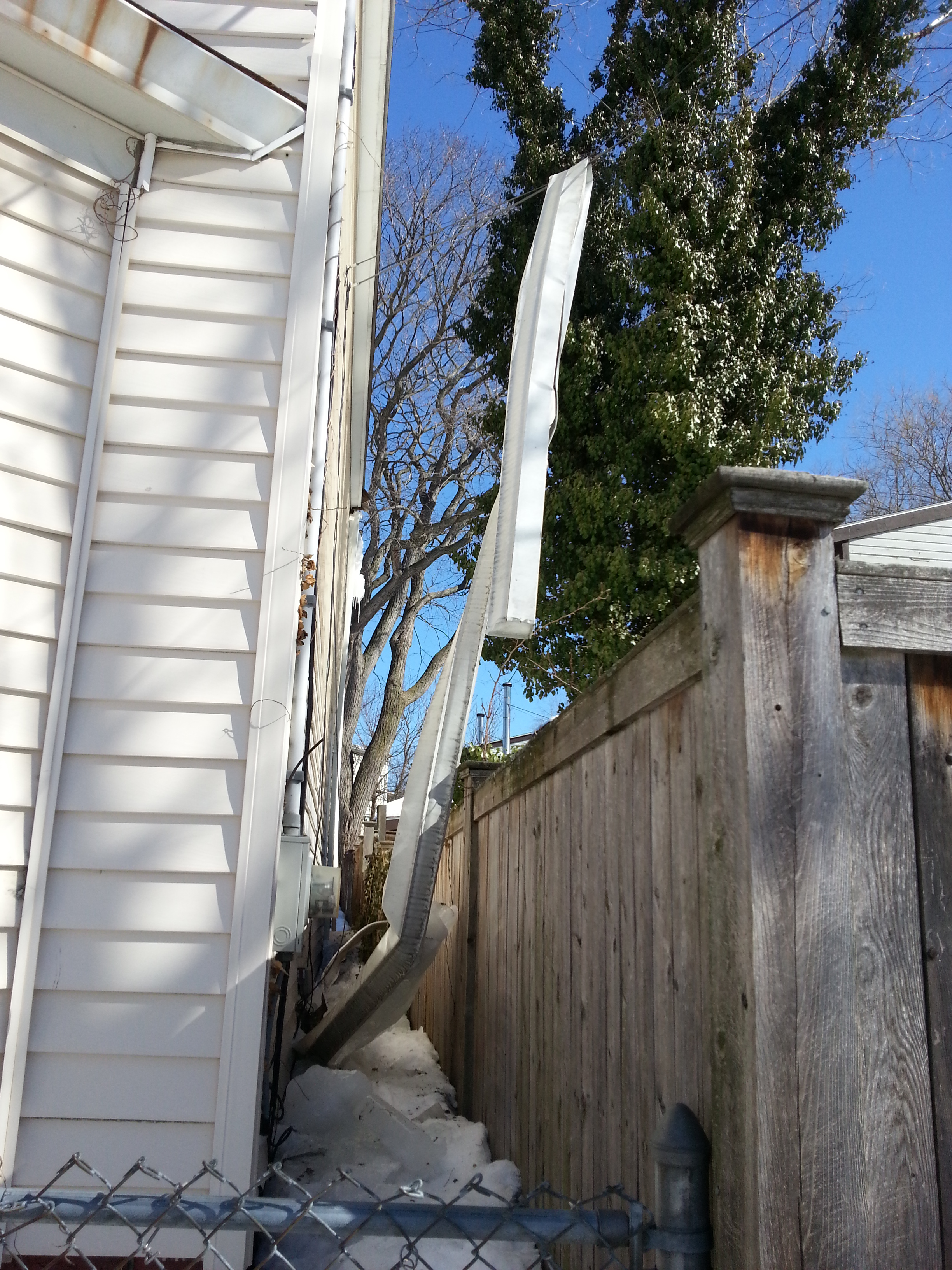
Gutter frozen with ice collapses off of a building and hangs suspended on a telephone wire. There's a metaphor for nature outsmarting humans there somewhere...
V
After writing the natural processes essay, I realize that visiting the site at different hours of the day made a tremendous difference in my observations. With special respect to Cardinal Medeiros, despite the apparent windiness in the afternoon, the chill was mitigated by the heat from the sun. However, returning in the evening, there was nothing to prevent or alleviate the wind chill. I hope to study the site in warmer months to know if wind in the corner conditions and along Cardinal Medeiros is strong enough to divert pedestrian traffic, or welcomed as a breeze. The importance of visiting the site multiple times was something I wish I had realized sooner. I felt like I didn’t gather enough information to bolster my arguments.
Something I would’ve liked to elaborate on was the presence of certain species of trees on my site. What was strange to me was that the majority of trees were not “volunteer species,” such as White Ash and Pear. Most of these trees actually looked relatively young, meaning that native trees were being planted regularly, despite their inadequate adaptability to the streets. On Broadway, the street was lined with Red Maples, which makes more sense.
Another thing I wanted to work into my essay (but didn’t really have a valid argument for that tied in with the thesis) was the strange ground conditions in the brick plaza. The bricks were set in sand, which means tree roots definitely had a warping effect. However, even in places where there were no trees (doorways of buildings) the bricks bulged upwards. Perhaps it’s nothing more than an aesthetic choice, but I wonder if it was caused by shifting ground.
The historical precedents of natural processes on my site could’ve been better explained if I had found an adequate topographical map. While I stand by my belief in that the site is immediately located on a marshland, it would’ve been nice to know the immediate surroundings, or the larger context of the site. Knowing elevations would’ve been especially useful with respect to the circulation of water and air.