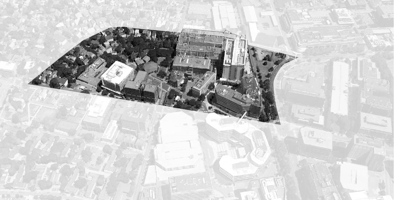
 Source: “Bird’s Eye of Site.” 42deg21’58.77” N 71deg05’30.38”W. Google Earth. August 24, 2013. March 6, 2015
Natural processes are regarded as cyclical events that run without disruption. While it is nearly impossible for humans to destroy natural patterns, it is often the case that the built environment and the natural environment clash in a variety of ways. Despite these conflicts, they also share a complex relationship of integration: while the natural environment shapes how humans build, the consequent development also shapes how natural processes are experienced. Indeed, circulation patterns of humans, air, heat, and water are unmistakably integrated through a series of complex causal relationships.
The development of this site begins with the Boston landfill project of 1630, which had a mirroring occurrence in Cambridge. From the landfill development map, it is clear to see that the completion of the Cambridge landfill occurred before 1795, indicating an early historical precedent of artificial ground (see Figure 1). From this map, one can also see that the landfill extended up into what seems to be a channel. With respect to the modern era, this could indicate an instability in that ground or a concentration of sewer systems. Unlike Boston’s intention to create more residential blocks, the Cambridge project was a means of filling in a delta to erect a railroad junction that would host the Boston-Albany railroad line. This is massively significant to the development of modern infrastructure, for the roads and smaller rail lines that stem from this junction would begin on filled land, which may or may not be as stable as undeveloped land, and/or may have made the development easier.
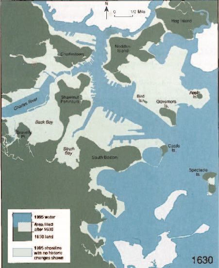
Figure 1: Map from Mapping Boston (Cambridge: MIT Press, 1999), showing artificial landfill around Cambridge in 1630 (site indicated by dotted red circle)
While the site wasn’t necessarily built on this filled land, it is situated on the periphery, which might imply a few things. Firstly, it would probably become a community dedicated to supporting the early railroad station. Secondly, the undeveloped land beside the developed land might conflict in terms of shifting stability. The validity of these claims is unclear, but it would seem that the site is situated mostly on marshland. The marshland would be an excellent way to dispose of sewage, or drain storm water. In addition, there is little to offer in terms of elevation change, which may play a part in the drainage system. Regardless, the decision to settle along the marshland was due probably to the wildlife that the marsh offered, and for the proximity to the Charles River.
The circulation of water on the site is probably closely related with the attributes of the marshland drainage system. While it is difficult to make a definite statement about the specific drainage on the site, the presence of leafy residential areas is a perhaps a clue as to how the water drains from the site. Since the apartment blocks are oftentimes surrounded by trees and lawn, the ground is relatively permeable, allowing for excess water to be removed “naturally.” On a city scale, the presence of wetlands as a method of flood prevention is demonstrated by the effectiveness of the wetland system of Boston: “In 1968 a large storm hit Boston, and urban runoff in the lower basin crested at the old Charles River Dam within hours. The upstream peak took four days to reach the dam. The wetlands in the headwaters filled with water, gradually releasing it over the course of a month” (Spirn, 155). Frederick Olmstead’s famous Emerald Necklace proposal serves to accumulate and drain water, while also providing natural beauty. While the lawns surrounding the townhouses are not nearly as well developed, they might be able to drain water to a similar effect.
On the other hand, in the industrial and commercial areas of the site, hard surface in the form of pavement and concrete is prominent. The relative impenetrability of this kind of ground means that water cannot drain so easily, leading to stagnant water. While an immediate effect is oftentimes pedestrian inconvenience, long-term effects of stationary water include accumulation of dirt and pollutants, as well as destruction of pavement. In the case of the site, drains seem adequate, although the major parking lot exhibited signs of extreme degradation, due to either disrepair or inadequate sloping for drainage.
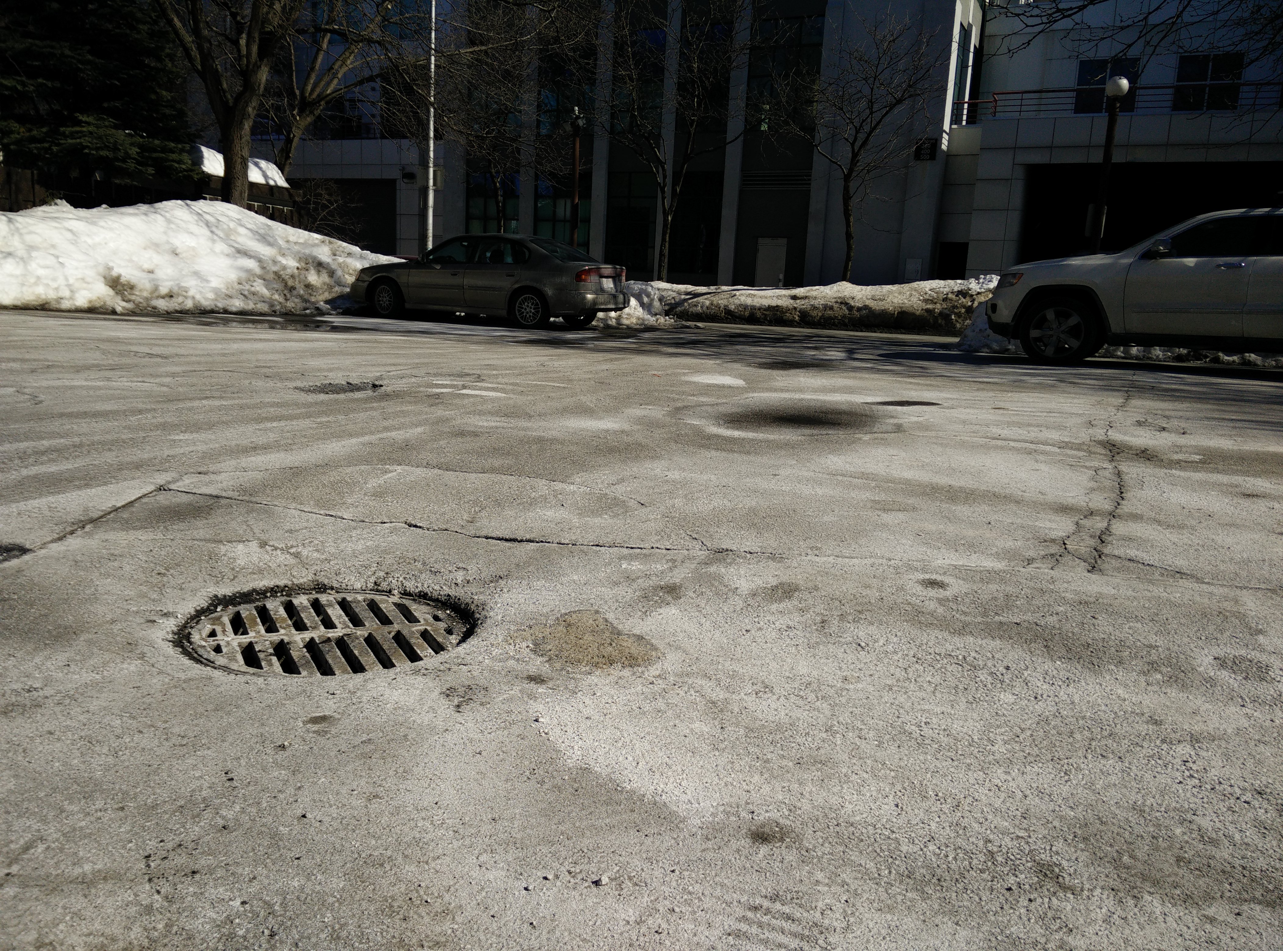
The pavement in this major parking lot on the site is beyond disrepair. The drain pictured here is not enough to remove all of the water pooling on the site. The pavement around the drain slopes towards the camera. The lines in the pavement indicate construction work, perhaps maintenance of the drain.
The disturbance of pavement also comes from the people themselves. At the busiest intersection on the site (Hampshire and Broadway), the traffic at the traffic light has consistently worn down the pavement under the stopped tires, forming two distinct grooves. Since the intersection occurs immediately after a turn, the angled tires probably help to wear down the pavement as well. These grooves can accumulate water, and consequently disturb other pavement pieces as it drains and freezes.
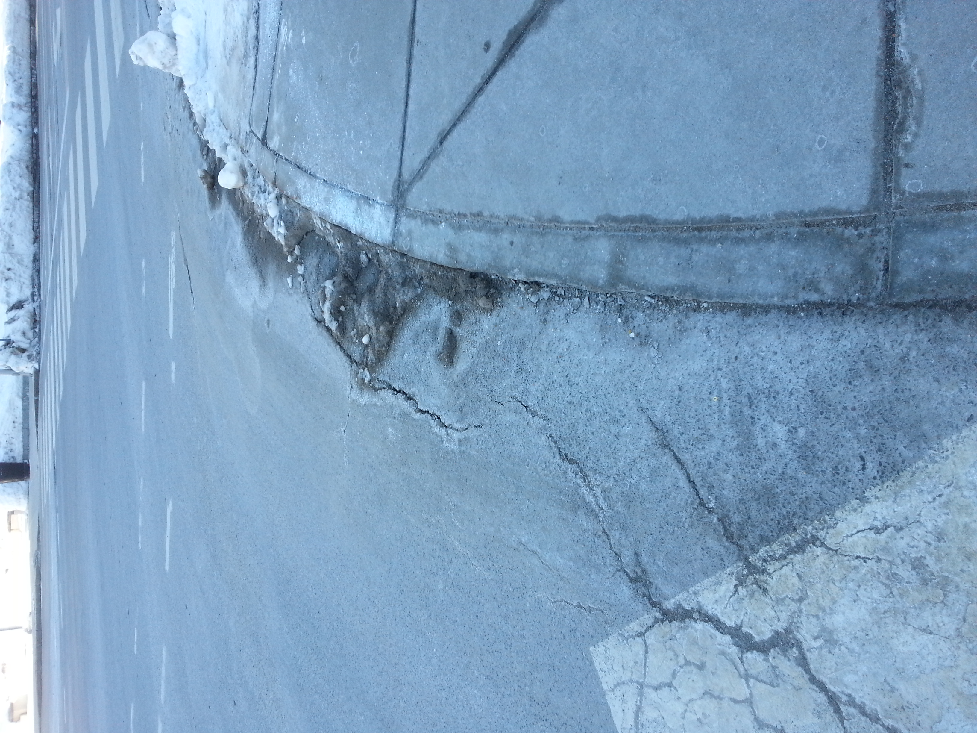
The edges of the road at the intersection of Hampshire and Broadway are also affected, due to accumulation of water from the sloping road.
Accumulation of water on the site is also exhibited through snow and ice. What is interesting is the effect that the snow and ice have on human structures. For example, the icicles that form on the south-facing side of residential buildings are due to insulation failures in the eaves, allowing heat to escape, melting the snow. When these icicles melt due to the sun, they drip and freeze on steps and sidewalks, rendering them nearly impassable, such as in the case of the picture below. While this phenomenon is completely preventable, it seems to be the case for most of the apartment blocks.
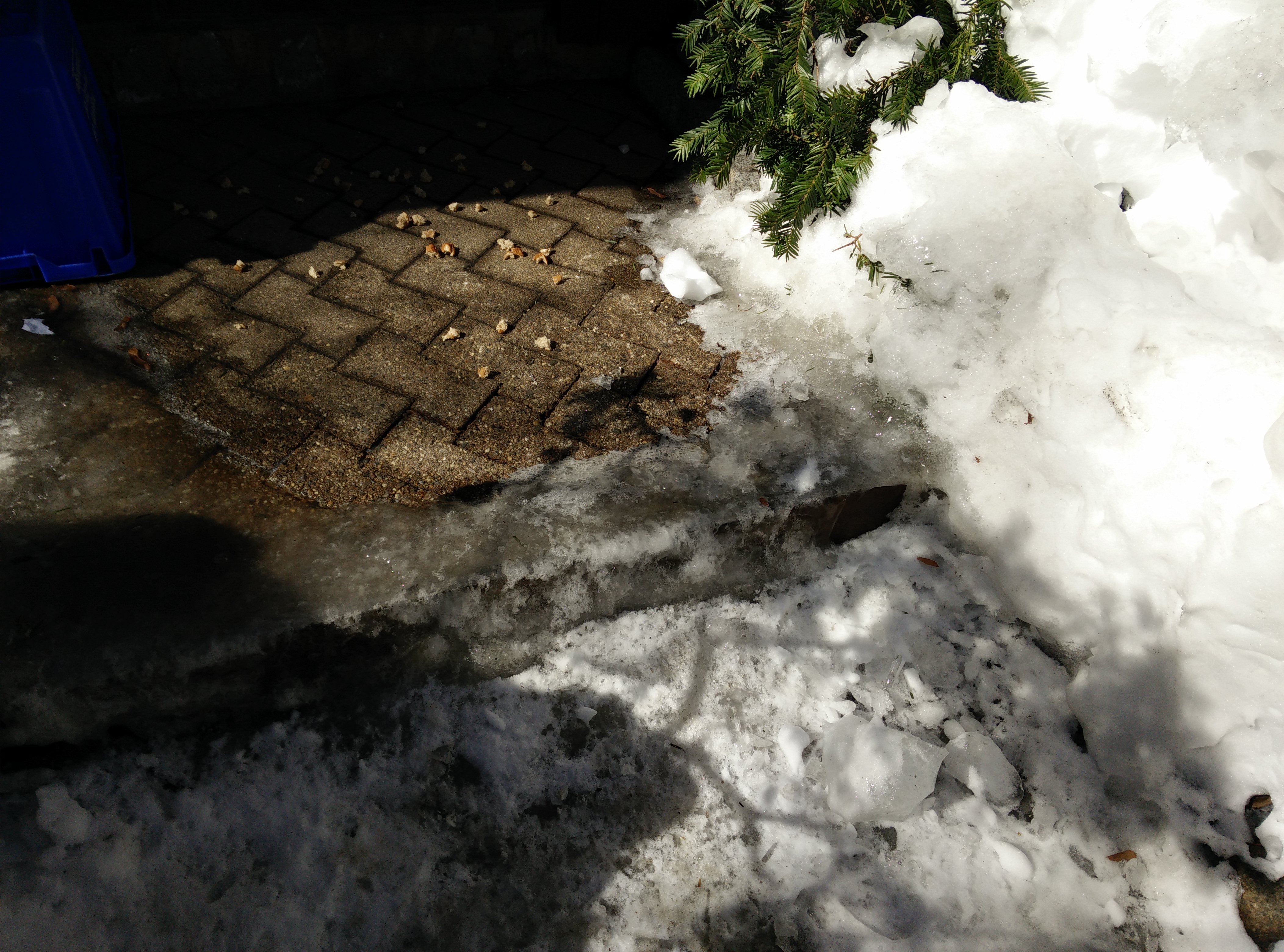
Melting water from the icicles formed on the eaves of the roof above the sidewalk freezes over on the sidewalk, causing slippery surfaces, and perhaps in the long-term, cracking.
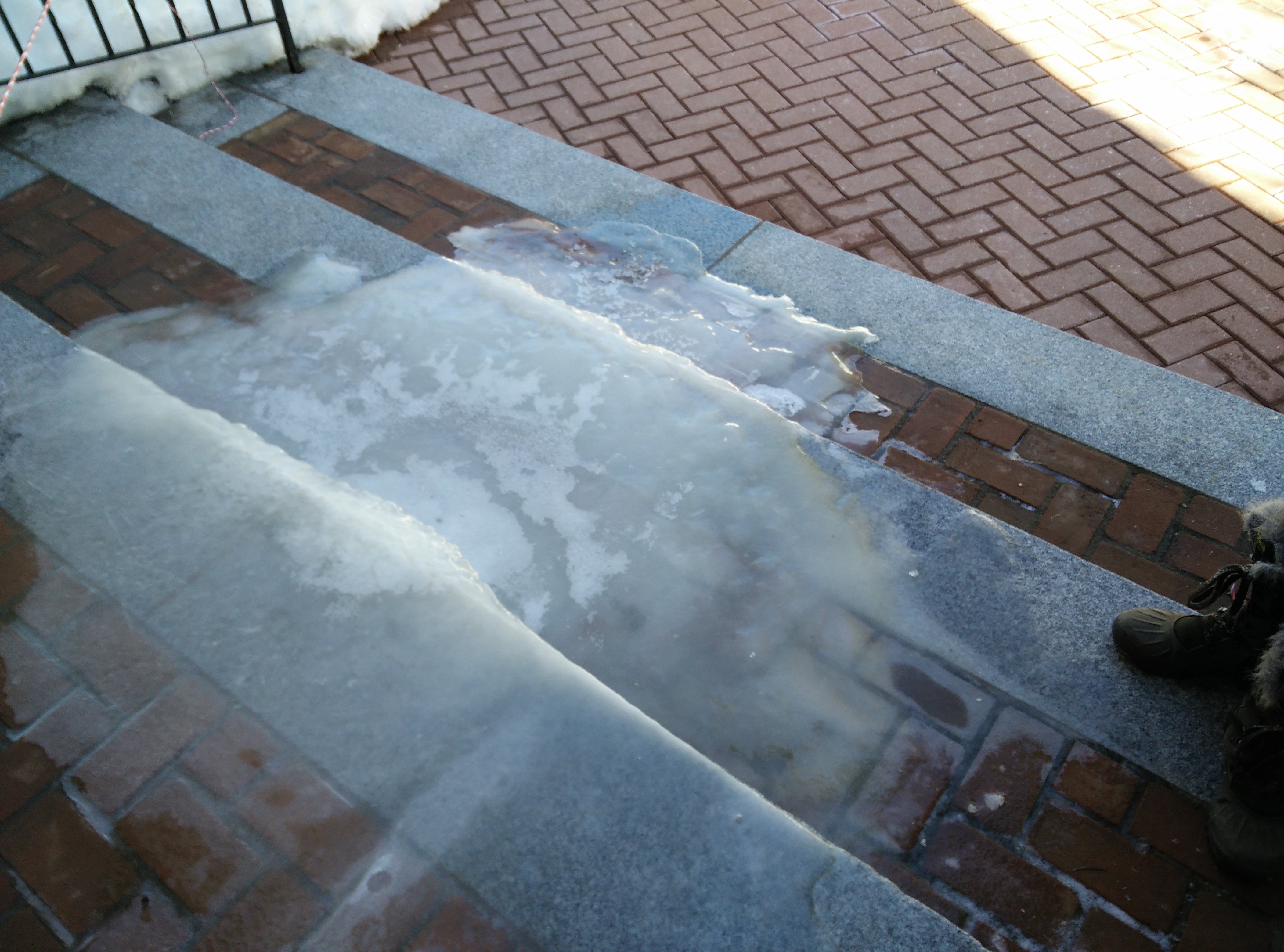
Melting water from the icicles formed on the eaves of the Italian Cultural Center (above the photo frame) freezes over on the set of stairs, causing a dangerously slippery surface. Photo credit to Daniel Lizardo.
Circulation of air in the site is seemingly credited to winds from the Charles River. However, the industrial buildings that frame the site perhaps serve to block the residential streets from the gusts. Due to their adequate tree coverage, the permeable surfaces mentioned earlier also serve to slow winds approaching these areas. For north/south prevailing winds, however, the story radically changes. Cardinal Medeiros Avenue, which hosts many commercial and industrial buildings, lines up with the cardinal south, making it an interesting case of an urban canyon. This problem is further augmented by the lack of street trees along the avenue. Winds such as those directed at the ground by the John Hancock tower are not present on the site, because the height of the buildings is not as high.
The layout of some buildings also allows for uncomfortable gusts. Corner conditions are instances in which winds are pulled through the space between the buildings and into the empty brick plaza. Were it not for this inconvenient channel, the plaza would serve as a quiet, intimate gathering space. Open, unprotected gathering spaces, such as the one outside Boston’s Government Center could use trees to improve the quality of the space from a pedestrian or inhabitant perspective.

The corner condition that exists between these two buildings leads to acceleration of gusts into the brick plaza. The space should be used for gathering and resting, but it remains vacant due to these miserable conditions.
The circulation of the air also implies the circulation of pollutants. The city system “dissipates, deflects, intensifies, and generates air movement that can, if guided, disperse pollution” (Spirn, 64). However, along streets with a lot of traffic such as Cardinal Medeiros, Broadway, and Hampshire, it seems that here the pollutants are concentrated. In fact, pollutants are far more concentrated along Cardinal Medeiros, for three reasons. Firstly, truck loading for the laboratories occurs along Cardinal Medeiros. Secondly, there is a distinct lack of street trees to dilute the air of pollutants, and lastly, the snow on the sides of the road shows much darker sediment than those in residential streets as well as along Broadway and Hampshire. While the wind is strong along Cardinal Medeiros, it does not seem adequate enough to dilute the air of pollutants.
The circulation of natural processes in the site is sometimes in conflict with the movement of people and vehicles. Unlike in the case of circulating water, circulation of people on the site is allowed mostly by the presence of the hard surfaces mentioned earlier, and reduced with the presence of soft surfaces such as grass and tree base. This is not problematic in terms of the backyards of the apartment complexes, which host most of the soft surface on the site, but it suggests an emphasis of human circulation. For example, the biggest park on the site is about 2500 square feet, about half of which is dominated by wide asphalt paths and a playground. In this case, the quality of the park, in terms of tree coverage and lawn surface, is perhaps compromised because hard surface is more attractive to movement.
Circulation of people is also hindered by water on the site. Even the hard surfaces, which allow for movement, are compromised due to ice formations from the melting icicles. Stagnant water in parking lots and sidewalks also provide a hurdle for pedestrians. However, what seems to be the most significant problem on the site is the way in which plowed snow on the sides of the streets provide a barrier to passing vehicles. On Webster Street, the two-way road has become barely negotiable by one. In order to avoid congestion, the cars must be diverted elsewhere. On streets such as Webster, which both serve as residential and connection paths, the problem of diverting becomes more serious. In this way, the accumulation of water profoundly affects the movement of people.
To conclude, the site demonstrates a complex relationship between humans and nature. It’s difficult to say whether the site is successful in its relationship with natural processes. It would seem that Cardinal Medeiros poses a large problem to pedestrians, but the elegant use of permeable surfaces for draining in residential areas is quite effective. Through the interaction between heat, air, water, and human circulation, we see both conflict and symbiosis. The water that drains from the site is both aided by the built permeable surface, and hindered by the built impermeable surfaces. The water that collects in hard surfaces hinders human movement, but helps to create cooler microclimates through evaporative cooling. The air that disperses pollutants from the streets also creates miserable conditions under other circumstances. So, while nature and humans benefit each other, the circulation of each are sometimes hindered.
--------------------------------
References
All photos by author unless otherwise noted.
Spirn, Anne Whiston. "The Granite Garden: Urban Nature and Human Design." New York: Basic Books, 1984. Print. “Fema Flood Plain Map.” The Works. Cambridge Department of Public Works, 2015. Web. 01 Mar. 2015.