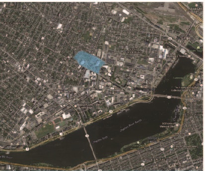
 Plan of site in city context. Photo courtesy of Google Maps
Located at the periphery of two major Cambridge districts, the site chosen for research and discussion shows a variety of unique relationships. It is the combination of such relationships, along with their development over time, that have ultimately created the community known today. While the initial research is focused on the system of infrastructure and land use, later studies will show how this specifically affects the development of the community, and perhaps what other relationships could affect such development.
The site is primarily bounded by two major pieces of infrastructure in Cambridge: Broadway and the Grand Junction Railroad. At the city scale, both are significant due to their ability to connect the site to other towns such as Somerville and Boston. Hampshire Street, which runs through the middle of the site, profoundly affects the area in a similar way, for Hampshire Street divides the Area 4 district from Mid-Cambridge. While Hampshire Street could be described as a break between the two districts as Clay says, “Original grids were hardly big enough for growth…At that point, the old railroad grid was abandoned, and beyond the one-mile roads, new streets shifted to follow the national grid…” (47), the paths the other roads follow are similarly explained. The final boundary of the site, Binney/Bristol Street, is such a case. There is not much to suggest a particular significance about the curve of the road, except to resolve the changing grade between the Mid-Cambridge grid and that of Area 4. Through the lens of infrastructure, it is then clear to see that the site lies at the intersection of different district and town cultures, creating an interesting foundation for studying development.
To give an idea of the extent to which the site is able to combine these two district cultures, first the cultures should be established. Common in both districts is the structure of densely populated residential blocks. However, Mid-Cambridge offers more diversity in its land use, as it serves as an institutional center, a hub of transportation, and includes major commercial centers. It is also important to note the proximity of Kendall Square and MIT campus; considering the increasing amount of technological influence these two areas impart on surrounding areas, the area in question will prove to succumb to the expansion as well. With the combination of culture in mind, a discussion of the extent to which the site exhibits such a combination can be properly evaluated.
To give a general idea of the land usage of the site, it would be beneficial to note that the majority of buildings on the site are for residential purposes. Interestingly, they form a sort of central core in the site, with community and public areas scattered within and around the site boundary. In fact, the major infrastructure components of the site could be considered as an axis for the commercial and institutional structures of the site. With this in mind, bordering the Grand Junction Railroad is a series of biology laboratory buildings such as Draper and Amgen, additionally providing some sort of depressing humor in its juxtaposition with the rarely used technology of a bygone era. Likewise, Broadway hosts some of the locally owned businesses and restaurants, in addition to public parks. However, within the confines of publicly accessible buildings lies a community that seems to be thriving under the pressure of its corporate neighbors. This could be attributed partly to the presence of young families, who probably have business in the laboratories, the offices in Kendall Square, or MIT campus. The site visit yielded no encounters with elderly people, yet many (relative to blizzard conditions) young couples walking, and sounds of children laughing from backyards. Walking north on Hampshire street yields a quiet looking Italian cultural center, surrounded by trees and residential blocks. Turning onto Cardinal Medeiros Avenue reveals the Kendall Square Cinema, a theater locally known for marketing and exhibiting independent films. At the intersections of residential streets such as Bristol and Hampshire, corners are named for residents who have shown outstanding performance in the community. George P. Blair Square, named for the man who was formerly a Cambridge police officer, shows such a level of closeness and respect. While the residential area is dominant on the site, the presence of public and community spaces seems to play a huge factor in the community’s development and how the people have adapted to their space.
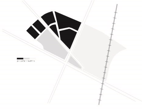 Diagram of public and private blocks in the site
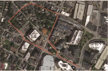 Initial route taken through the site. Photo courtesy of Google Maps
Initially, the approach to studying the site was to analyze the relationship between infrastructure and community development according to the infrastructure. After site visits and more thought, the relationship between the public and private sphere in the site is quite obvious, but still incomplete in terms of the effect on the inhabitants. While land use and infrastructure have been discussed, the relationships yet to be explored, such as natural processes, societal shifts, and historical development are still required to understand the site holistically.