Over the last three centuries, like many American cities, Cambridge transformed from a rural landscape in the 18th century, to an early suburban landscape in the 19th century, and an increasingly more urban landscape in the 20th and 21st century. Such a tale, of American urban development is closely explored in Kenneth Jackson’s Crabgrass Frontier. Suburbs, although once thought of as “socially and economically inferior to cities,” (Jackson, 19) soon rose to prominence in the 19th century as cities became increasingly over crowded and industrialized. Throughout this period of rapid growth, many neighborhoods, which were once developed as suburbs of urban metropolises, were absorbed by swift urban growth. Through a close look at the development of the Cambridgeport neighborhood and Central Square, from 1700 to the present, we begin to gain insight in the process of suburban and later more urban patterns of densification and commercialization in the American city. Through a close study of maps, we begin to understand that role that social, cultural, economic and technological factors played in the rise and fall of the American suburban and urban experience.
In 1700, Cambridge, a rural area, with marshland along the river, was a largely under developed. The Plan Showing Cambridge Highways as Existing in the Year 1700, focus on the natural features found in the area such as marshes, creeks, rivers, ponds, Islands, and hills. Infrastructural development in the region is minimal, with the map representing only a small number of roads. The greatest density of roads is in the Harvard College area, and shows a small 3x3 street grid. From this grid, small highways extend out toward the surrounding areas. The highways are named for where they lead e.g. Highway to Pelham’s Island, Highway to Captains Island. This map was created to indicate the highways as they existed in 1700, and therefore perhaps intentionally, does not indicate the built structures that existed at the time. All the same, there are very few built roads, suggesting low levels of development in the surrounding region.
 Figure 1 : The Plan Showing Cambridge Highways as Existing in the Year 1700. Area of study is marked by red circle.
Between the early and the later part of the 18th century, little development occurred in the region. The 1777 Cambridge & Vicinity in Revolutionary Times Compiled to show the parole limits of the Burgoyne’s Officers (Figure 2) shows a region at a similarly low level of development to that show in the map from 1700. While this map also focuses on the natural and physical features of the area, it begins to indicate the existence of taverns, churches, and burying places. The placement of these social and cultural centers may have been of particular importance to the map users at the time.
 Figure 2 : Cambridge & Vicinity in Revolutionary Times Compiled to show the parole limits of the Burgoyne’s Officers, 1777.
The highway to Pelham’s Island, (Figure 2) which extends eastward along straightest trajectory toward Pelham’s Island, connected users to some of the surrounding islands and natural features such as marshland, Great Neck, and Captain’s Island. As we follow the development of the region over time, we will come back to the Highway to Pelham’s Island. The highway to Pelham’s Island, (Figure 2) which extends eastward along straightest trajectory toward Pelham’s Island, connected users to some of the surrounding islands and natural features such as marshland, Great Neck, and Captain’s Island. As we follow the development of the region over time, we will come back to the Highway to Pelham’s Island.
Despite the connection to these surrounding islands and other natural features, Cambridge remained relatively isolated from the Boston area. In 1662, the Great Bridge, which connected Cambridge and Allston, was constructed. Located near the Harvard College campus, the Great Bridge remained the only bridge across the river until the West Boston Bridge construction in 1830. Perhaps it was a result of this limited access and connectivity that Cambridge remained relatively rural until the early 19th century.
In 1793, construction of the West Boston Bridge, (today called the Long Fellow Bridge), connecting East Cambridge to Boston, was completed. As Cambridge became increasingly more connected to the Boston downtown, development and construction progressed. By the early 1800s, Cambridgeport was on route to becoming a major manufacturing port. In 1804, the first soap factory was established in the area, prompting other manufacturers to follow. The New England Glass Company, Cambridge’s first major industry, soon followed in 1814. Shortly after these developments, Cambridgeport was established as a Cambridge neighborhood (1808). By 1830, the neighborhood was in the early stages of development. Plan of Cambridge From Survey Taken in June 1830 by John G. Hales, (Figure 3, Figure 4) shows these early stages in the development of this new suburban landscape. The layout of these large street streets is similar to the layout we see today, with a main street traversing out from Harvard Square, eastward, and extending across the river toward Boston.
 Figure 3: Plan of Cambridge From Survey Taken in June 1830 by John G. Hales. Area of study encircled in red.
 Figure 4: Plan of Cambridge From Survey Taken in June 1830 by John G. Hales. Detail
Main Street is an important feature to examine, because it later becomes the main commercial street in Central Square, Massachusetts Avenue, and we must examine how Main Street became what it did. In the 1777 map of Cambridge, the Highway to Pelham’s Island was the main eastward moving road. The road followed the straightest mainland trajectory from Harvard College toward Pelham’s island, and branched out to the surrounding Captain’s Island and Little Neck. As you follow the development of the region over time, there are two main points that suggest that Main Street and the Highway to Pelham’s Island are the same. The first point being that each road sits between two small rivers or creeks, in the lower left corner of Goffe’s Cove. The second is the directional alignment of the road between the creeks. In both the 1777 map of Cambridge and the 1830 map, the Highway to Pelham’s Island and Main Street each follow the same directional trajectory (Figure 5). Main Street in the 1830s maps runs through the center of what will later develop into Central Square.
Main Street is not the only developed street, the 1830 Plan of Cambridge, also shows the extension of streets moving southwest, toward the river. Six streets extend down toward the river, however only two are named on the map: Watertown Road (Current day Western Avenue) and Brighton Road (Current day River Street).
As I continue to explore Central Square, and the surrounding Cambridgeport neighborhood, I will also look at the different architectural styles, and how those styles have worked to create particular zones within the neighborhood. Cambridgeport, is a far quieter, more residential area outside of Central Square. Architecturally, it is a mixture of wood construction triple-deckers, brownstones, and stand alone wood construction, Victorian homes. Toward Central Square, buildings become a taller, eclectic mix of old and new, brick, stone, and wood. How do these physical elements, create particular zones for users? How do the streets change as you walk through the site?
At this point many people were using horse and carriages as main modes of transportation. Development remained rather compact. Buildings, on the 1830 Plan are indicated by small black dots. The density of buildings is greatest along Main Street, suggesting that much of the development in this area began along this Main Street, and extended northeast toward Charlestown or southwest toward the river. Streets south of Main Street are developed, but with far less density than that represented on Main Street. Development extends only as far down as Auburn Street and as far north as Harvard Street.
However, with the increase of industry in the area and the construction of connecting bridges to Boston, Cambridge continued to grow at a steady pace. By 1832, the Cambridge Town hall moved from Harvard Square to Central Square, as a result of the rising concentration of commercial activity in the Central Square/Cambridgeport neighborhood.
Over the next 70 years, the area of Cambridgeport established itself further as a mixed residential and commercial neighborhood. Massachusetts Avenue, which ran from Harvard Square developed as the commercial zone, while the areas just north and south, developed as residential zones (Figure 5). Commercial shops were, for the most part, located directly along Massachusetts Avenue, and Prospect Street. Small-scale industrial shops, like a tin shop, upholstering shop, and print shop, could be found intermixed along, and tucked in with the Main Street shops (Figure 5). Some of these industrial shops overlapped in terms of what they sold and the products they produced. For example, three print shops were all within walking distance of the bookbindery (Figure 5). Along Prospect Street, on the block just off of Massachusetts Avenue, one could find wallpaper shops, upholstery shops, and picture frame shops, all of which pertained to the décor of the home (Figure 5).
 Figure 5:Plan of Cambridge From Survey Taken in June 1830 by John G. Hales with detail - Red line indicates Main Street. Red circle indicates the penisula by the flats. Right - 1777 Cambridge & Vicinity in Revolutionary Times Compiled to show the parole limits of the Burgoyne’s Officers. Red line indicates Main Street. Red circle indicates the penisula by the flats.
Throughout the later half of the 19th century, Cambridge was experiencing a sharp increase in population growth. With a population of approximately 20,000 people in 1856, Cambridge’s population more than doubled to 48,000 people by 1872. The increasing in population growth influenced the design and development of home types, and in 1880, the first triple-deckers were built in Cambridge.
However, in Cambridgeport in 1900, the majority of homes types were defined as single-family dwellings (Figure 5). In the area between Auburn Street and Harvard Street, Norfolk and Essex Street, and Inman and River Street, there were approximately 250 homes. Just twenty-nine of these were defined as flats or apartment style homes. The prevailing single-family identity of the homes in the area, speaks to the development of the region as a predominantly wealthy upper-middle class suburb. Those who lived here sought more space and fresh air.
Religious institutions were scattered throughout the neighborhood, many of them just one or two blocks away from the other. Within the borders of Harvard Street, Norfolk Street, Pearl Street, and Auburn Street, there were five churches. These churches included, the First Baptist Church, The First Universalist Church, Prospect Street Congressional Church, and Saint Mary’s R.C. Church. The variation in church types, speaks to the mainly Christian, Protestant, or Catholic religious affiliation of residents in the surrounding neighborhood.
Throughout the early part of the 20th century, the commercial and residential spaces in the area continued to grow and prosper. Throughout the early part of the 20th century, Central Square remained the commercial center of Cambridge, but in 1912 with the opening of the MBTA line, Central Square “lost its significance as a commercial center.”
By 1934, we see a substantial shift in the home types, and the number of commercial spaces throughout the site. By 1934, many of the homes in Camrbidgeport had been converted into Flats. In the area between Auburn Street and Harvard Street, Norfolk and Essex Street, and Inman and River Street, there were approximately 80 flats. The stock market crash just five years earlier, in 1929 may have been a contributing factor to the division of homes, into smaller apartment style dwellings.
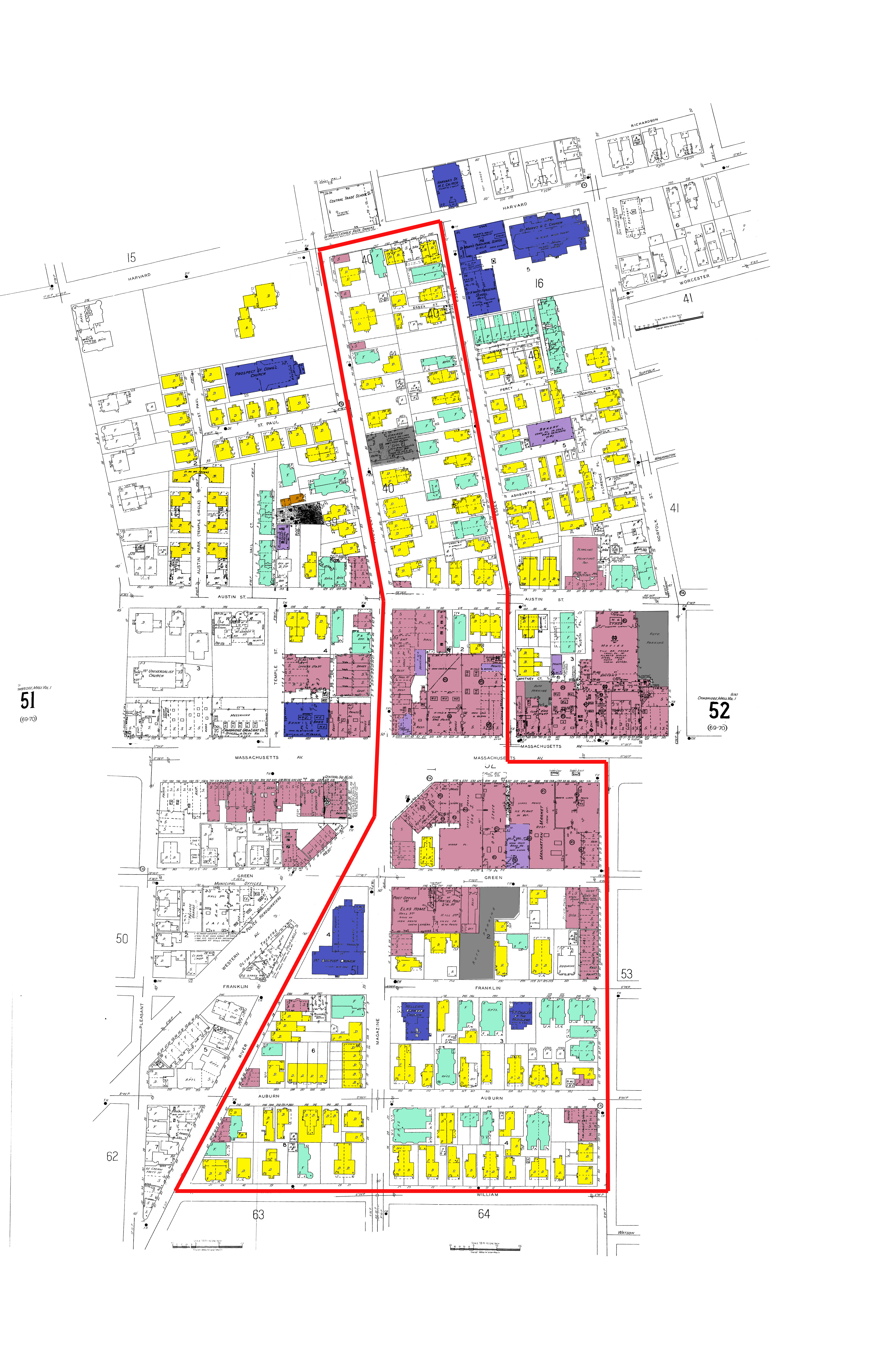 Figure 6: Cambridge, Massachusetts [map]. 1900. "Sanborn Fire Insurance Maps, 1900". Digital Sanborn Maps 1867-1970. (1 Apr 2015). Red: Retail Space; Yellow: Single Family Dwelling; Turquoise: Flats/Apartments; Purple: Industrial; Blue: Institutional; Grey: Parking lots.
Despite the economic instability brought by the Great Depression, the 1934 map shows expanded commercial areas along Massachusetts Avenue (Figure 6). Commercial spaces took over entire city blocks. However, it is unknown how many of these commercial spaces remain occupied during this period. Some of the commercial and residential spaces, have been knocked down, and converted into parking lots, the first of which we see on the block between Green Street and Franklin Street (Figure 6). The reasoning behind this action could have been economic, but it also could have been greatly influenced by the increasing popularity of the automobile.
The automobile had come to the forefront nearly two decades earlier, and by 1934, as seen in the maps, it had established itself as a basic necessity in the middle-class household In these 1934 maps we begin to see the structural influences of the car on the urban fabric. Garages appear on many of the back yards of homes. Approximately 30 homes indicated the presence of a garage on their property (Figure 6).
Religious institutions throughout the site also reflect a changing makeup of residents. Within the borders of Harvard Street, Norfolk Street, Pearl Street, and Auburn Street, remain the First Baptist Church, The First Universalist Church, Prospect Street Congressional Church, and Saint Mary’s R.C. Church (Figure 6). However, along Franklin Street, two new churches have appeared. On the corner of Magazine Street and Franklin Street, the Greek Orthodox Church and School appear on the map, suggesting perhaps a substantial influx of Greek residents to the neighborhood. Further down on Franklin Street is the Christian Church of Nazarene. The increased variation in church types, speaks to the increased diversity in the neighborhood. Once predominantly a Christian and Protestant community, the presence of new church types reveals a changing user group.
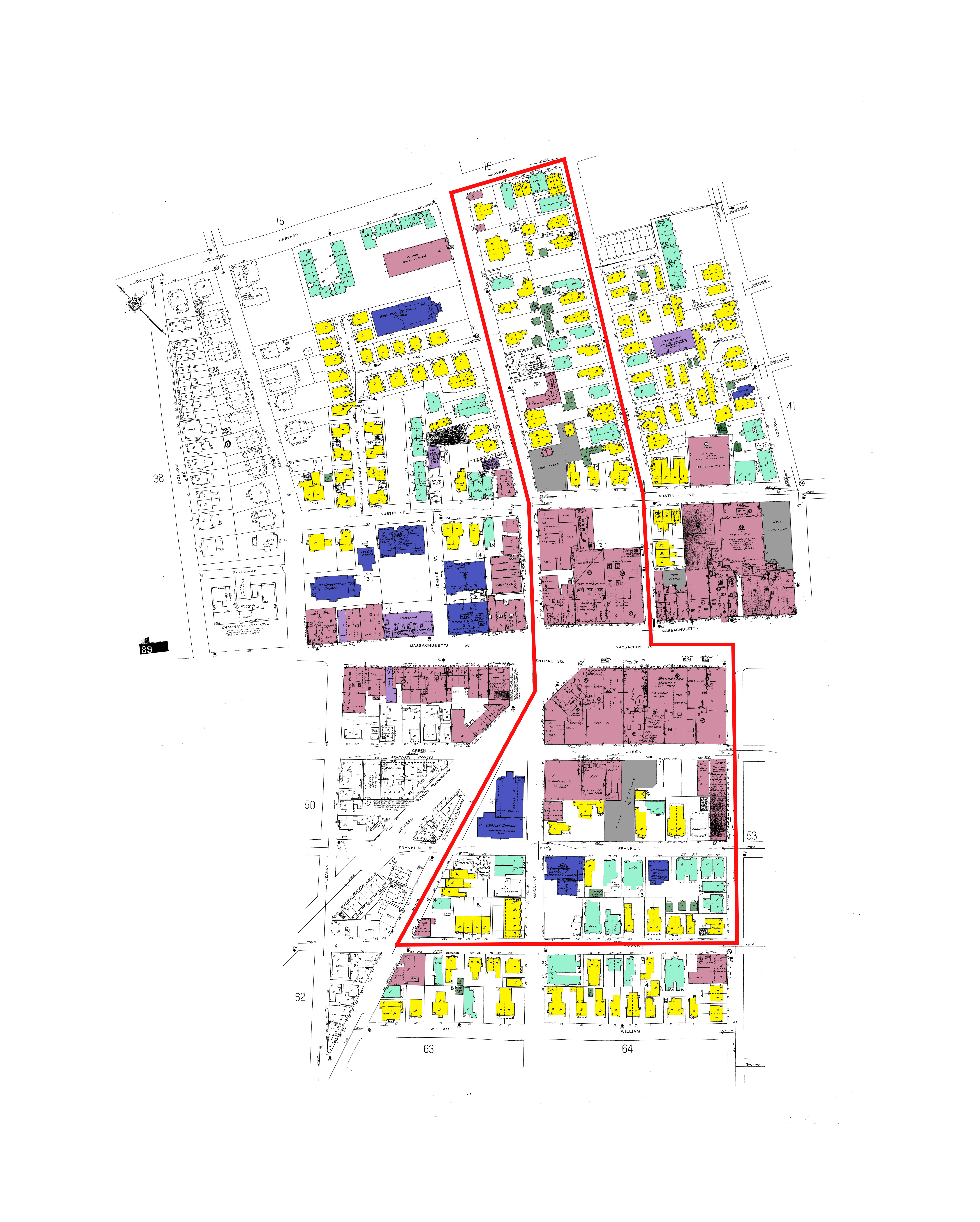 Figure 7: Cambridge, Massachusetts [map]. 1934. "Sanborn Fire Insurance Maps, 1934". Digital Sanborn Maps 1867-1970. (1 Apr 2015). Red: Retail Space; Yellow: Single Family Dwelling; Turquoise: Flats/Apartments; Purple: Industrial; Blue: Institutional. Grey: Parking lots.
The post war period of the 1950s saw a dramatic rise in consumer driven culture. The automobile was taking over American cities, and large central arteries were appearing in cities across the United States. By 1950, construction of I-93 in Boston had begun.
By 1950, Cambridgeport/Central Square had become an increasingly more urban center. The single family home was no longer the prevailing home type. In fact, the number of dwellings and flats was almost equal. Many of the homes that had once been single-family houses, had been converted into multifamily flats. However, the site also reveals the economic depreciation of the site, through the rise of vacant lots (Figure 7). Some of the lots were converted into parking lots, while others remain blank plots on the site.
![]() Figure 8: Cambridge, Massachusetts [map]. 1950. "Sanborn Fire Insurance Maps, 1934".
Digital Sanborn Maps 1867-1970. (1 Apr 2015). Red: Retail Space; Yellow: Single Family Dwelling; Turquoise: Flats/Apartments; Purple: Industrial; Blue: Institutional; Grey: Parking lots. Empty lots indicated by green outlines.
Figure 8: Cambridge, Massachusetts [map]. 1950. "Sanborn Fire Insurance Maps, 1934".
Digital Sanborn Maps 1867-1970. (1 Apr 2015). Red: Retail Space; Yellow: Single Family Dwelling; Turquoise: Flats/Apartments; Purple: Industrial; Blue: Institutional; Grey: Parking lots. Empty lots indicated by green outlines.
By 1950, more homes indicated the existence of garage structures. We continue to the see the affects of the automobile on the urban fabric, as garages, parking lots, car dealerships, and car repair shops appear throughout both north and south of Massachusetts Avenue.
Smaller religious institutions continue to appear throughout the site, reflecting varying religious affiliation of residents. By 1950, the site is home to seven religious institutions including the First Baptist Church, The First Universalist Church, Prospect Street Congressional Church, the Greek Orthodox Church, and the Church of Nazarene. The increased variation in church types, speaks to the increased diversity in the neighborhood, once predominantly mainly Christian, Protestant community, by 1934 represent the Greek Orthodox Church as well.
In the years that followed, Central Square settled into a period of depreciation. The increasingly car oriented American culture drove many consumers to commercial centers outside of the city, where they could drive up and park their cars comfortably. The increased dependence on public transportation, made it easier for those who used to shop in Central Square, to reach the center of the city, therefore bypassing the commercial center. In recent decades, Central Square has experienced a substantial economic revival, as people move back into the city in search of a denser, more walkable urban experience.
By tracing this neighborhood’s past we start to gain insight in the cycles of urbanization, and the patterns of densification and commercialization in the American city. As people continue to shift toward denser and more urban settings, it is important to take into consideration the social and economic effects that result from changes in modes of transportation. Changing modes of transportation played a large role in the design and development of Central Square and Cambridgeport. The filling of marshlands, and development of roads and bridges, allowed for greater ease in travel from Cambridgeport to the city center. Such ease in transportation contributed to the neighborhood’s success as an early suburb. The increase in the number of bridges connecting Cambridge to the greater Boston area, as well as increased industrialization and manufacturing, lead to increased development and urbanization in the region. The introduction of public transportation, however, made it easier for consumers to cross over to Boston, and subsequently lead to neighborhoods economic demise. With a post war push for a more car-oriented society, central Square and Cambridgeport became increasingly inconvenient places for people to live and shop. Homeowners sought the vast open spaces of the suburbs, and consumers sought the convenience of a park-and-go shopping experience. In essence, transportation, and the subsequent changes that occurred throughout the course of the 20th century, altered our experiences of the urban fabric. Todays, as we return to more human scale modes of transportation, such as bikes, it is important for us to think about the ways that this change may affect our social and economic urban experiences; as it becomes increasingly more valuable to live in urban settings, we must take into consideration the ways that demographics shift both inside and outside the city limits. How will we promote the continued survival of these rural and suburban settings? In this age of technologicl advancement, are such settings worth saving?
Bibliogrpahy
Book Jackson, Kenneth. Crabgrass Frontier. New York: Oxford UP, 1985. 161. Print.
Website
Spirn, Anne. "Timeline." Once and Future City. Massachusetts Institute of Technology School of Architecture and Planning, 1 Jan. 2012. Web. 1 Apr. 2015.
Maps
Cambridge, Massachusetts [map]. 1900. "Sanborn Fire Insurance Maps, 1900". Digital Sanborn Maps 1867-1970. (1 Apr 2015).
Cambridge, Massachusetts [map]. 1934. "Sanborn Fire Insurance Maps, 1934". Digital Sanborn Maps 1867-1970. (1 Apr 2015).
Cambridge, Massachusetts [map]. 1950. "Sanborn Fire Insurance Maps, 1950". Digital Sanborn Maps 1867-1970. (1 Apr 2015).
Cambridge & Vicinity in Revolutionary Times Compiled to show the parole limits of the Burgoyne’s Officers, 1777
Plan of Cambridge From Survey Taken in June 1830 by John G. Hales
Plan Showing Cambridge Highways as existing in the Year, 1700