Justin Carrus
4.211: The Once and Future City
Assignment 4: Traces and Trends
If walls could speak...
The story of a site is one to be read by the careful eye. When one examines a location, time shows its face in the details. The present state is simply a manifestation of the past, frozen for but a moment. Through careful observation, one can unpack the stories from the past to reveal how the past has left its mark, quite literally, on the walls, the pavement, and the people.
In her book, The Power of Place, Dolores Hayden argues that the urban landscape is a product of design, social history, and cultural identity (Hayden 1995). This could not be more true in the context of the Lafayette Square site. While this site finds influence throughout its history and from all fronts, the most prominent actors would have to be the design decisions during the early years of the site, the societal trend of suburbanization, and the identity of the individuals that have called this location home. Evidence of each of these three forces can be found today in the details of the site, and analysis of the past, through the evidence found in the present, hints at what the future may hold.
Trends of Design: Early Decisions
The exposition to the story of my site establishes location, which has dramatic ramifications for the ensuing development. The earliest maps available show the present site existing on Pelham's island, a body of firm land surrounded by marsh. While the island itself is long gone, a trace of the "Highway to Pelham's Island" still exists in present day Massachusetts Avenue. The road itself may not exactly follow the original path of the highway, but all roads lead to somewhere, and it is not difficult to attribute the path of such a major through way to the existence of a destination, the island.
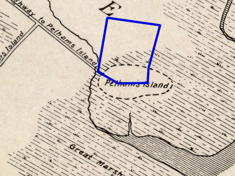 Figure 1: This maps shows a road named
"Highway to Pelham's Island" as early as the year 1700. This
road follows a similar path to Massachusetts
Avenue. (Hastings 1919)
Figure 1: This maps shows a road named
"Highway to Pelham's Island" as early as the year 1700. This
road follows a similar path to Massachusetts
Avenue. (Hastings 1919)
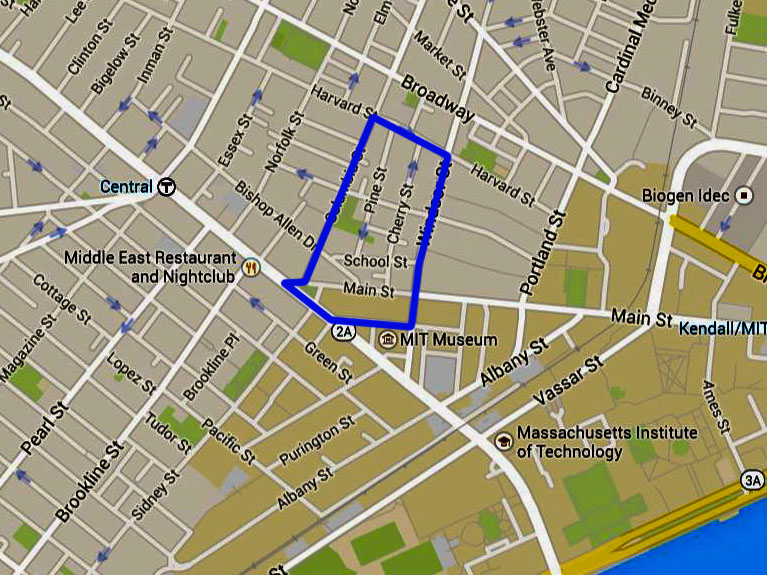 Figure 2: This current map shows the
routing of Massachusetts Avenue today. Note the similarity to
the "Highway to Pelham's Island". (Google 2015)
Figure 2: This current map shows the
routing of Massachusetts Avenue today. Note the similarity to
the "Highway to Pelham's Island". (Google 2015)
The existence of this island, and the original highway may also be seen today in the intersection of Main Street and Massachusetts Avenue. For much of the site's history, these two streets were combined as Main simply bent from Central Square to continue over the West Boston Bridge to the center of the city. The old configuration of Main Street can be seen not only in historical maps (Hopkins 1873), but also the traces that still exist in the location (Figures 3 and 4).
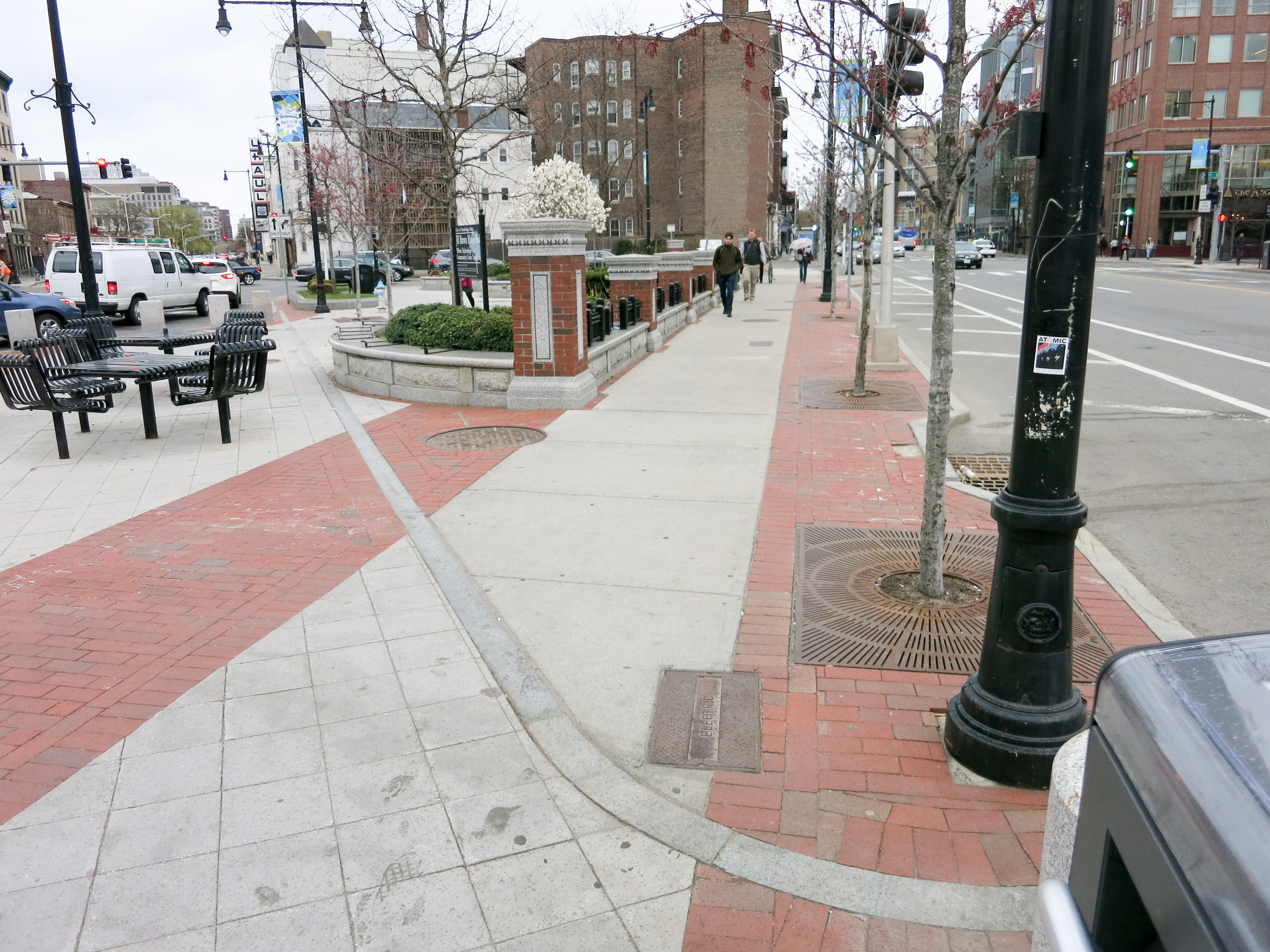 Figure 3: Notice the path that the gray
blocks follow. It appears as though the bricks want to follow
the original path of Main Street. (Photo by author)
Figure 3: Notice the path that the gray
blocks follow. It appears as though the bricks want to follow
the original path of Main Street. (Photo by author)
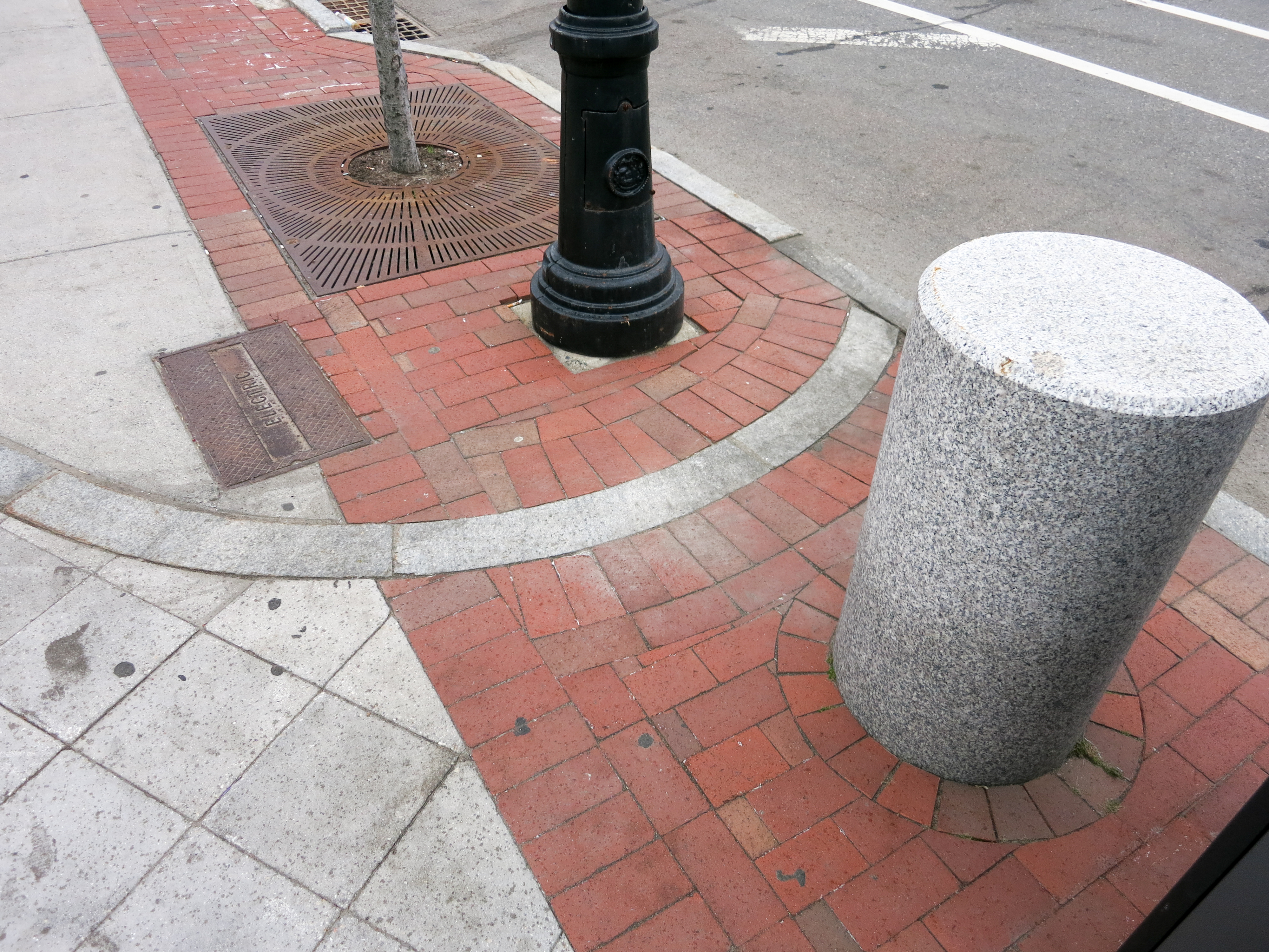 Figure 4: A close-up of the brickwork at
the same location as Figure 3. Notice the curve that the gray
bricks follow. The break in the pattern of bricks is a trace
of the old configuration of Main Street. (Photo by author)
Figure 4: A close-up of the brickwork at
the same location as Figure 3. Notice the curve that the gray
bricks follow. The break in the pattern of bricks is a trace
of the old configuration of Main Street. (Photo by author)
The physical routing of Main Street also had an influence on the paths followed by street cars. The journey between Central or Harvard Square and Boston seemed to be a popular one and very quickly, street cars rolled through Main Street to connect these two hubs. The street cars have left their mark in both the history books through maps (Mason 1861) and in the current routing of the MBTA subway. On ground level, both the rumblings beneath the surface and the vents pictured in Figures 5 and 6 remind visitors that the Red line rolls beneath the street. This of course is a continuation of the street car lines that predate the underground subway, and in turn, shows influence from the original highway to Pelham's Island, albeit less directly.
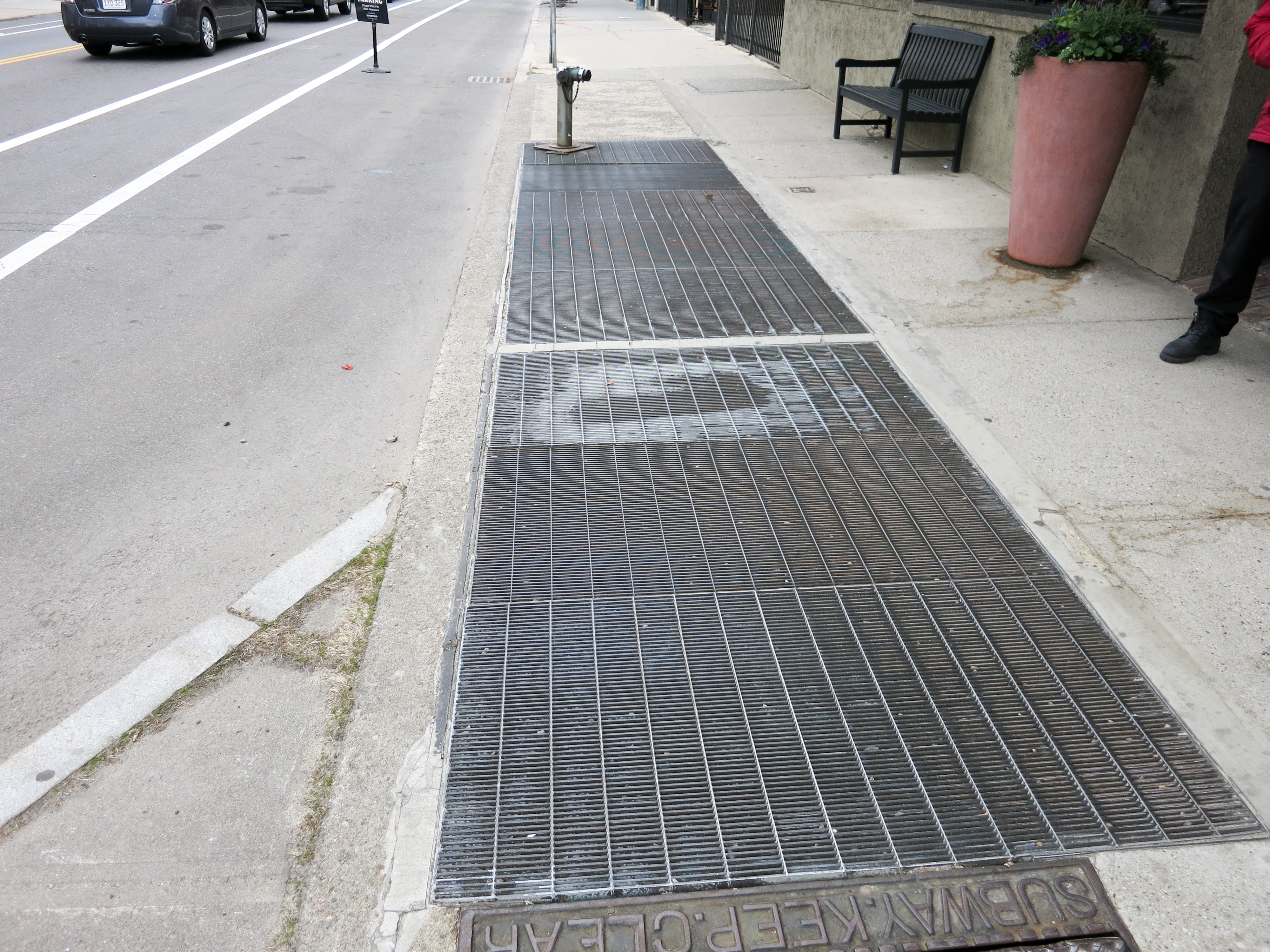 Figure 5: A grate on the sidewalk
reminds visitors of the Red line that runs beneath. The subway
follows the path of the original street cars, a trace of the
past. (Photo by author)
Figure 5: A grate on the sidewalk
reminds visitors of the Red line that runs beneath. The subway
follows the path of the original street cars, a trace of the
past. (Photo by author)
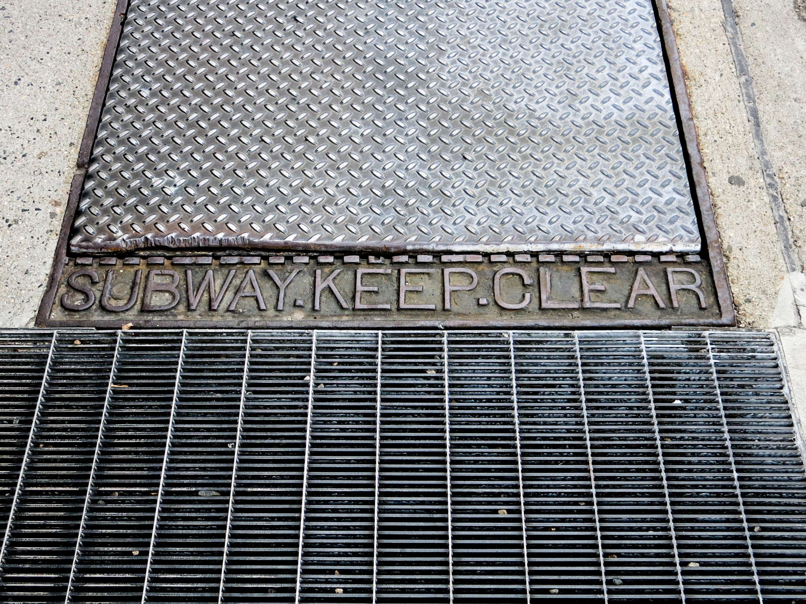 Figure 6: A close up of the grating that
directly point out the purpose of the grating: the
subway. (Photo by author)
Figure 6: A close up of the grating that
directly point out the purpose of the grating: the
subway. (Photo by author)
The initial location and design decisions surrounding the site clearly influenced the routing of Main Street and eventually also the subway. Furthermore, the traffic and settlement served by this through way necessitated a fire station. In 1852, a City of Cambridge fire station opened at 789 Main Street (Figure 7) and remained in operation until 1894, at which point the location was abandoned for the nearby location at what is now 378 Massachusetts Avenue (Firefighters 2009). This point in time is significant because it comes just a few years after the completion of the Harvard Bridge in 1891 which probably increased the relative importance and desirability of Massachusetts Avenue when compared to Main Street (HAER 1968).
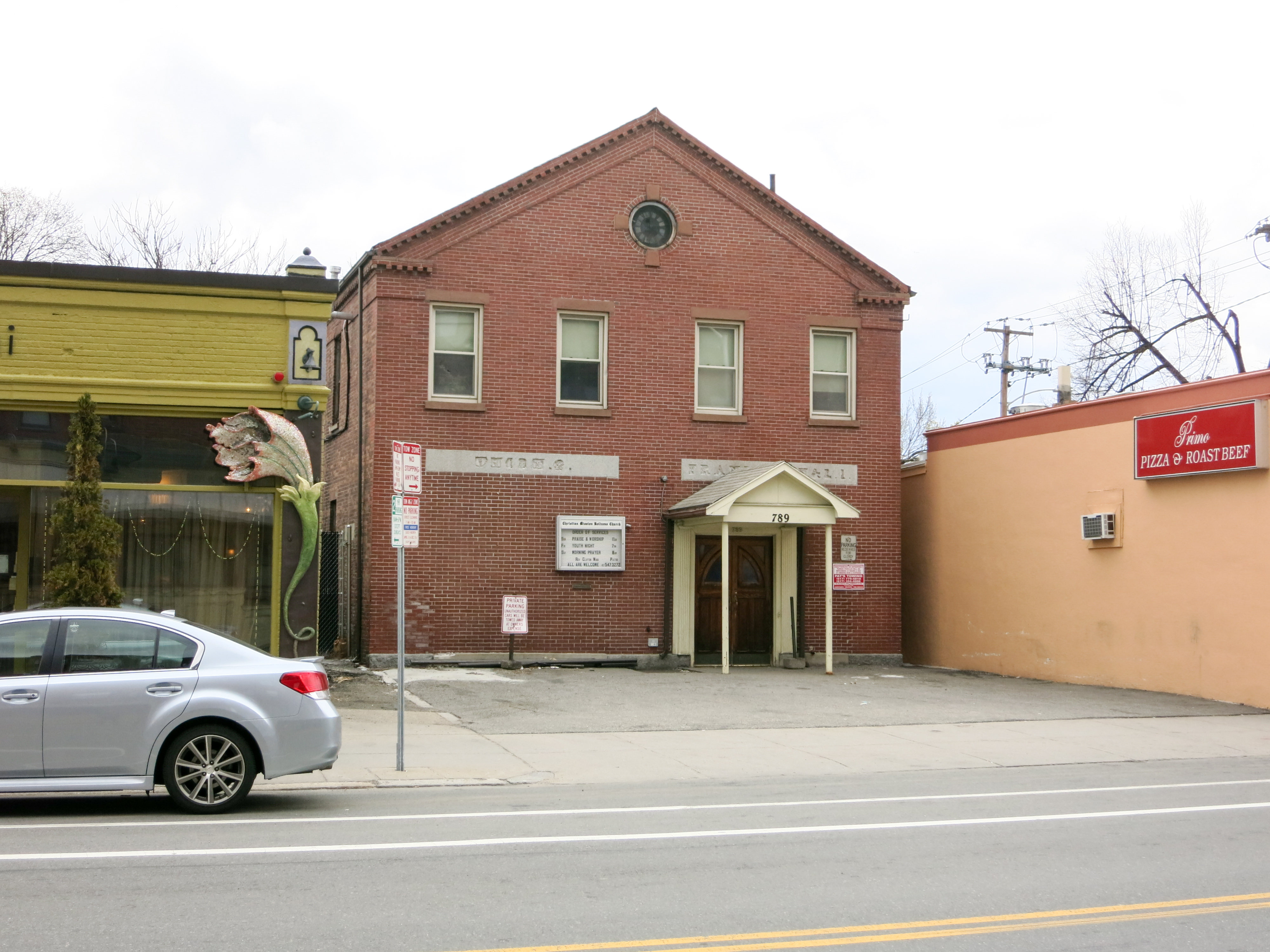 Figure 7: The facade of the old fire
station. The stone work reads "Union 2" and "Franklin H & L
1", indicating the home of fire engine 2 as well as the
Franklin hook and ladder truck. (Photo by author)
Figure 7: The facade of the old fire
station. The stone work reads "Union 2" and "Franklin H & L
1", indicating the home of fire engine 2 as well as the
Franklin hook and ladder truck. (Photo by author)
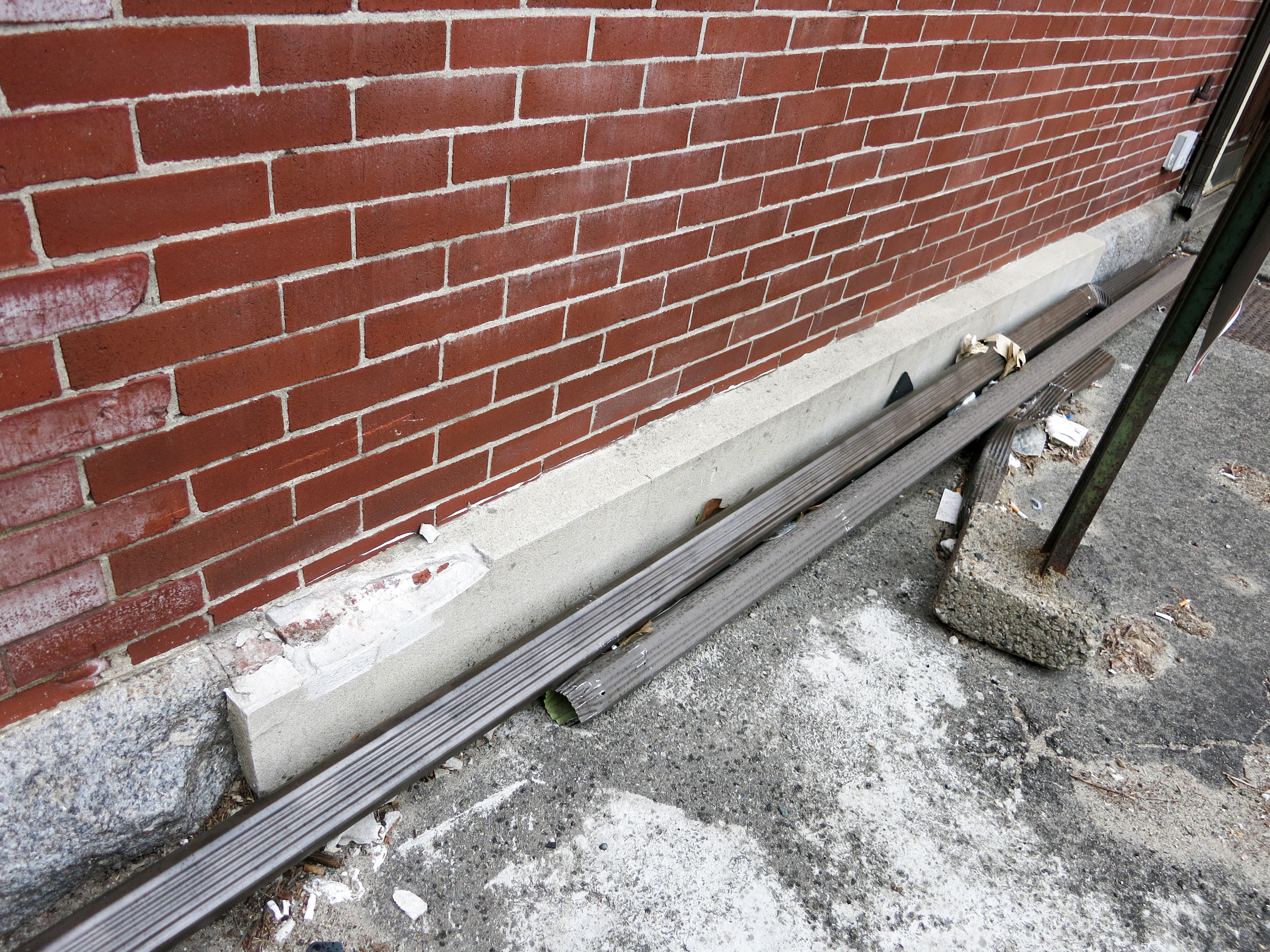 Figure 8: At ground level, one can see
the break in the stone work that came about when the fire
station was converted to a church. The newer stone was put in
to seal the door originally used for the fire engines. (Photo
by author)
Figure 8: At ground level, one can see
the break in the stone work that came about when the fire
station was converted to a church. The newer stone was put in
to seal the door originally used for the fire engines. (Photo
by author)
The fire station building is an artifact of the early years of development of the site. This area, the immediate surroundings of Main Street near Lafayette Square, was settled very early relative to the surrounding land, a fact that presents itself in both the historical maps (Hopkins 1873) and the present structures on the site (Figures 7 and 8).
The original design of Main Street, a consequence of the location of Pelham's Island, has persisted through time in the urban landscape. The current form of Lafayette Square, the routing of the subway, and the physical structure of the old fire station are traces of the design decisions during the early years of development on the site.
Trends of Society: The Rise and Fall as a Suburb
Central to the plot of the site's story is the influence of societal factors. Political and economic trends guide the wants and needs of people, and in turn, push the urban landscape to provide. Most prominent on this site is the effect of suburbanization, a trend that initially brought people to this location, though eventually pushed them out.
As described in Assignment 3: Site Through Time, this location experienced rapid early development due to its status as a crossroads between Central Square and Boston. This initial boom led to a healthy patch of industry and commerce along Main Street as indicated by Figure 9. The site provided a good location for people to exist outside of the city proper, but still have access to the benefits of city life such as work and entertainment.
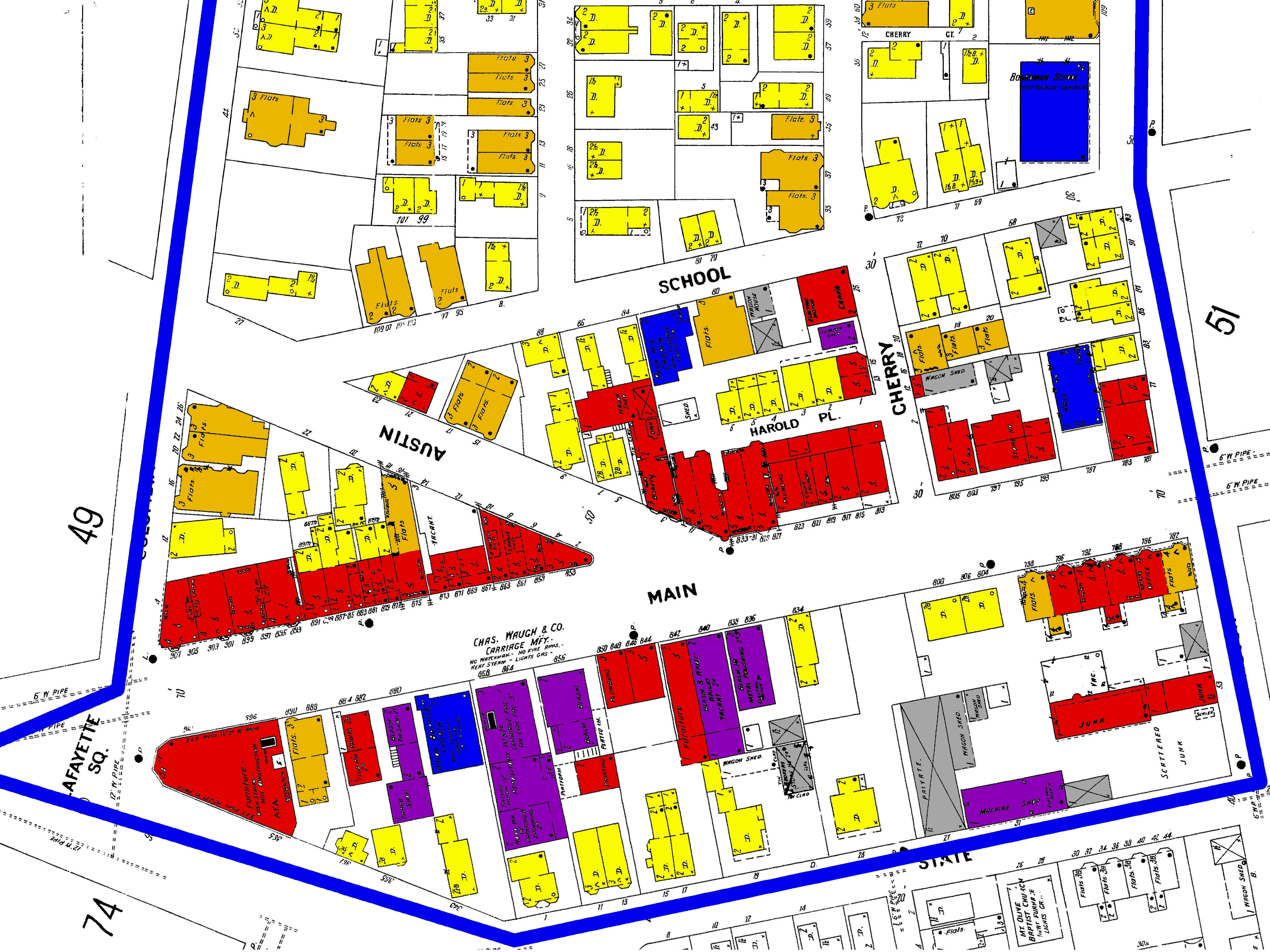 Figure 9: The 1900 Sanborn fire
insurance atlas. Note the large cluster of commercial (red)
and industrial (purple) land uses near Main Street. (Sanborn 1900)
Figure 9: The 1900 Sanborn fire
insurance atlas. Note the large cluster of commercial (red)
and industrial (purple) land uses near Main Street. (Sanborn 1900)
 Figure 10: The 1996 Sanborn fire
insurance atlas. Note the decreased number of shops and
industrial buildings. Much of the land is now being used for
parking. (Sanborn 1996)
Figure 10: The 1996 Sanborn fire
insurance atlas. Note the decreased number of shops and
industrial buildings. Much of the land is now being used for
parking. (Sanborn 1996)
With the passing of time, suburbanization would continue to push the suburbs outwards from the city, fueled by developments in transportation such as the Red line and the automobile. This in turn led to disinvestment in the area as indicated by historical maps (Figure 10).
This rise and fall can also be seen in the artifacts that still exist on this site. Most visible is the towering stone structure that still houses Cambridge Brands (Figures 11 and 12). The company is the last of a chain of food-related industry beginning before 1873 with the Teele, Howe, and Co. Bacon Works, and continuing through both the Boston Confectory and the Potter Confectory (Hopkins 1873, Bromley 1916, Bromley 1930).
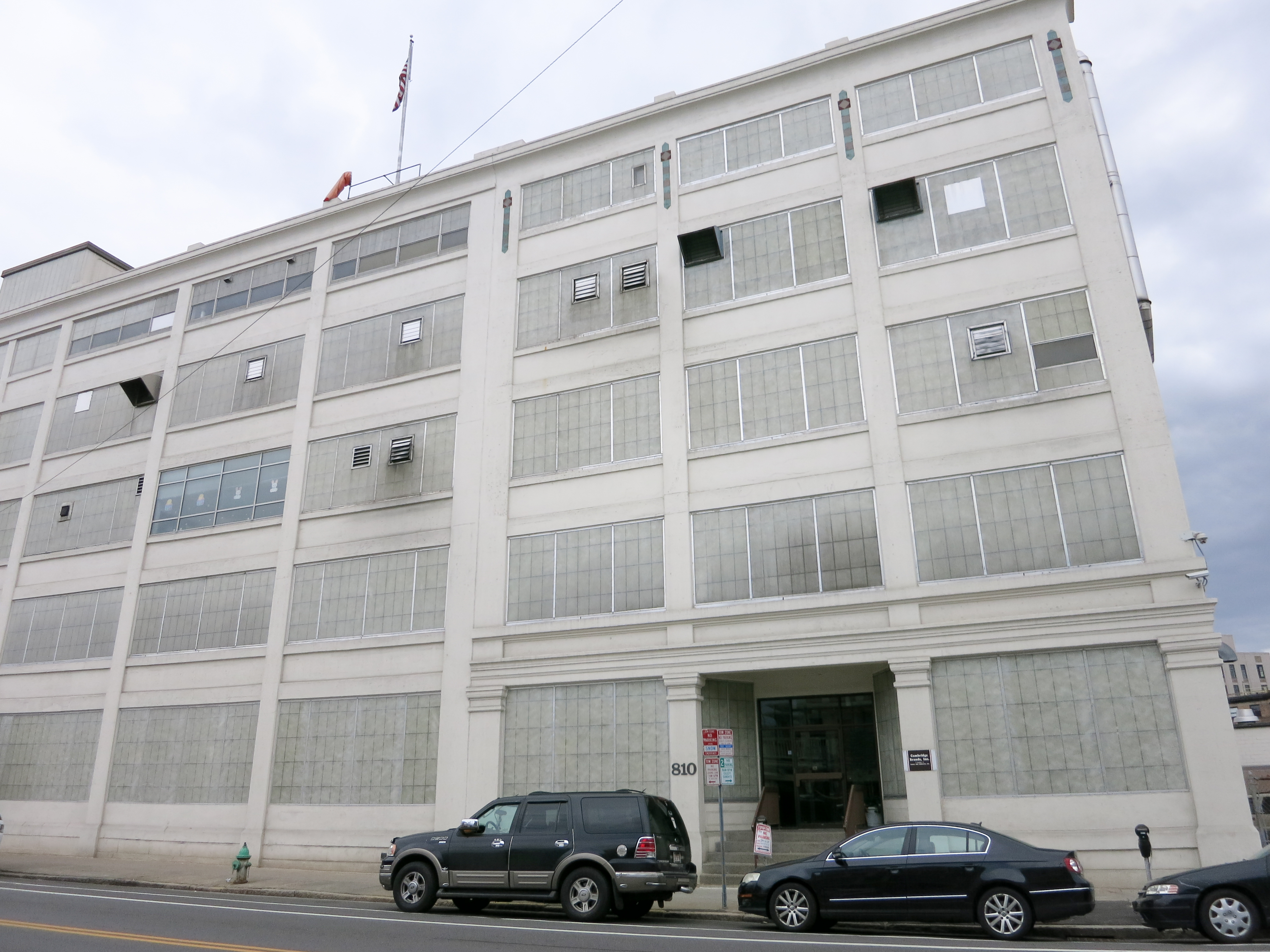 Figure 11: The facade of Cambridge
Brands is towering and repetitive. This structure stands on
the site of many previous industrial ventures such as the
Bacon Works and previous candy producers. (Photo by author)
Figure 11: The facade of Cambridge
Brands is towering and repetitive. This structure stands on
the site of many previous industrial ventures such as the
Bacon Works and previous candy producers. (Photo by author)
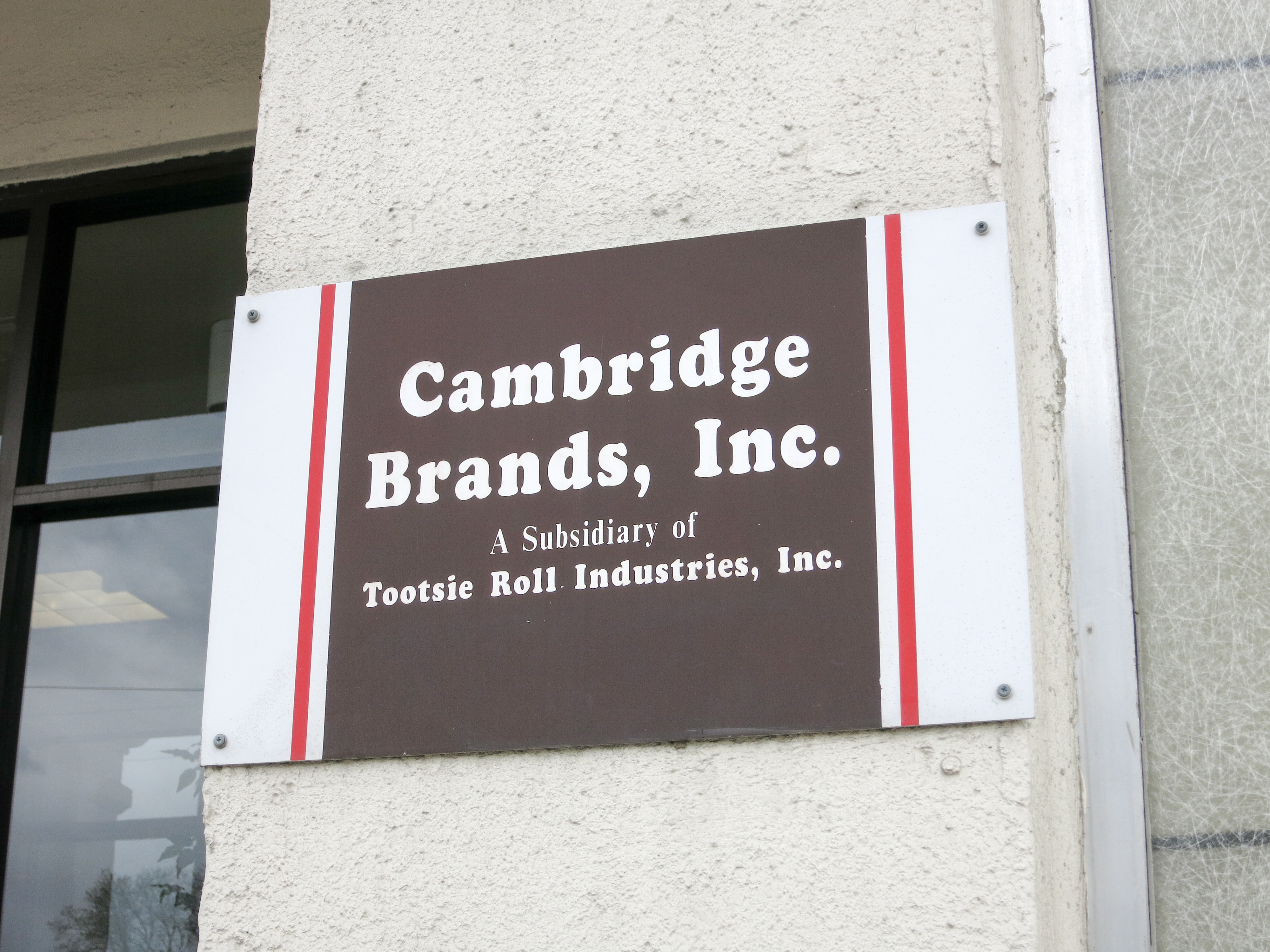 Figure 12: This sign is one of the few
indications of what may occur inside this building. (Photo by
author)
Figure 12: This sign is one of the few
indications of what may occur inside this building. (Photo by
author)
More subtle evidence exists for the once bustling Main Street. Uneven weathering on the sides of buildings such as the one pictured in Figure 13 is a trace of the buildings that previously lined this road. When the wave of suburbanization struck, the street was packed, but as time passed, many building were demolished and their old lots converted to parking.
 Figure 13: The bricks on the side of
this building have experienced uneven weathering due to the
previous existence of a neighboring building. This
discoloration is a trace of the past. (Photo by author)
Figure 13: The bricks on the side of
this building have experienced uneven weathering due to the
previous existence of a neighboring building. This
discoloration is a trace of the past. (Photo by author)
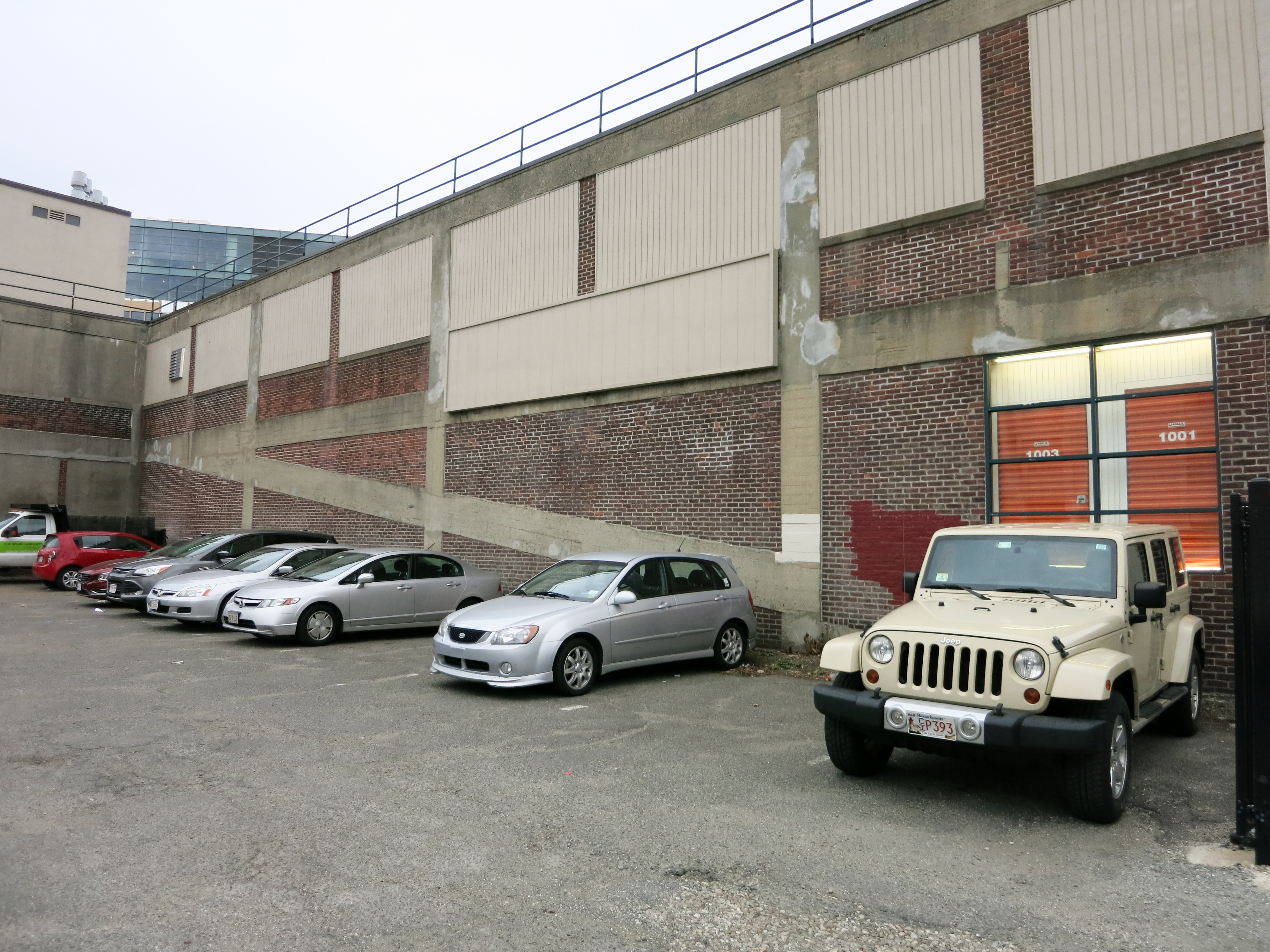 Figure 14: The side of the current
U-Haul building shows its previous purpose as a garage in that
one can see the slope of the concrete that connects the floors
of the structure. (Photo by author)
Figure 14: The side of the current
U-Haul building shows its previous purpose as a garage in that
one can see the slope of the concrete that connects the floors
of the structure. (Photo by author)
Correlated to the trend of suburbanization is the proliferation of the automobile. Historical maps show the rise of garages and other automobile servicing centers during the 1920s and '30s. As society was transformed by the personal people mover, so was the urban form. Garages, filling stations, and auto repair shops opened their doors to satisfy this new market. Evidence of this hey day is written on the walls of the site in that some of the structures of garages and filling stations still exist. Some time between 1916 and 1930, the Lafayette Square Garage opened for business, though the structure now houses a U-Haul (Bromley 1916, Bromley 1930). Visible on the side of the building is the concrete profile of the garage as the floor sloped upward from the ground to the upper levels of parking (Figure 14). The original use of this structure was a product of the social trends, and the current site holds visible traces of the past.
Trends of Culture: Residents and Identity
Whereas the initial design and societal forces provided broad direction for the development of the site, the residents have dramatically influenced the specific execution of development. These people are the characters to fill the story. They provide the action, the interpretation, and the personality that dictates the specific realization of the site. The choices they make, and the implications for the urban form are directed very simply by who they are. Their cultural identity leaves its mark on the landscape in ways that can be seen even today.
When leafing through historical maps for this area or even just walking around the site, one quickly realizes the prevalence and persistence of churches. Some of the oldest institutions on the site are churches, and many remain to this day. These institutions reveal characteristics of cultural identity within the population. Large amount of support are needed to create and sustain a church due to the high cost of initial construction and operating costs. These institutions have lasted for many years, and so, are good indicators as to what was, and continues to be, valued by the residents.
The oldest church still in existence today on the site is the Union Baptist Church, built in 1882 (Figures 15 and 16). As seen in the images, the church was not only maintained, but has been remodeled three times during its lifetime. This sign serves as an artifact of both the population of the site at the time of its founding, but also during the times of remodeling and continued support for the church. As verified by the church's website, this congregation has throughout time been largely composed of African Americans, and from this artifact, one can reasonably assume that throughout time, the residents of this site have been of this ethnic group.
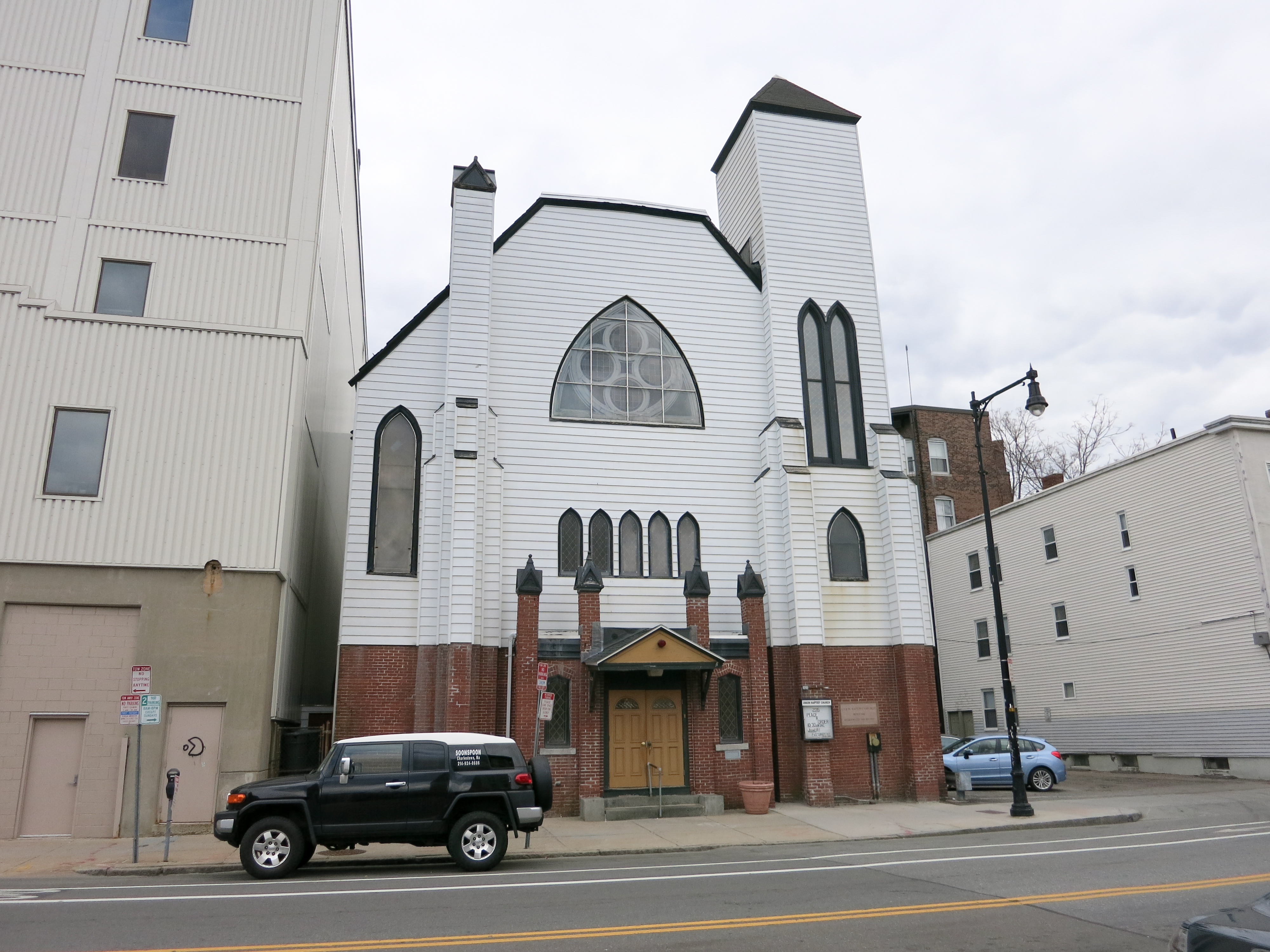 Figure 15: The facade of Union Baptist
Church. This building was erected in 1882 to serve a
congregation of largely African American residents. (Photo by author)
Figure 15: The facade of Union Baptist
Church. This building was erected in 1882 to serve a
congregation of largely African American residents. (Photo by author)
 Figure 16: Stone work on the front of
the Union Baptist Church indicates continual care and
community involvement in the church through the initial
construction and three remodelings. (Photo by author)
Figure 16: Stone work on the front of
the Union Baptist Church indicates continual care and
community involvement in the church through the initial
construction and three remodelings. (Photo by author)
This trend is also visible in other churches. Take for example the Rush AME Zion church on School Street. This church was founded in 1888, and continues to hold services to this day (Figure 17). This congregation is also mostly African American, and because of this, one can assume there to be a fairly substantial African American population in this area from the very early days of settlement.
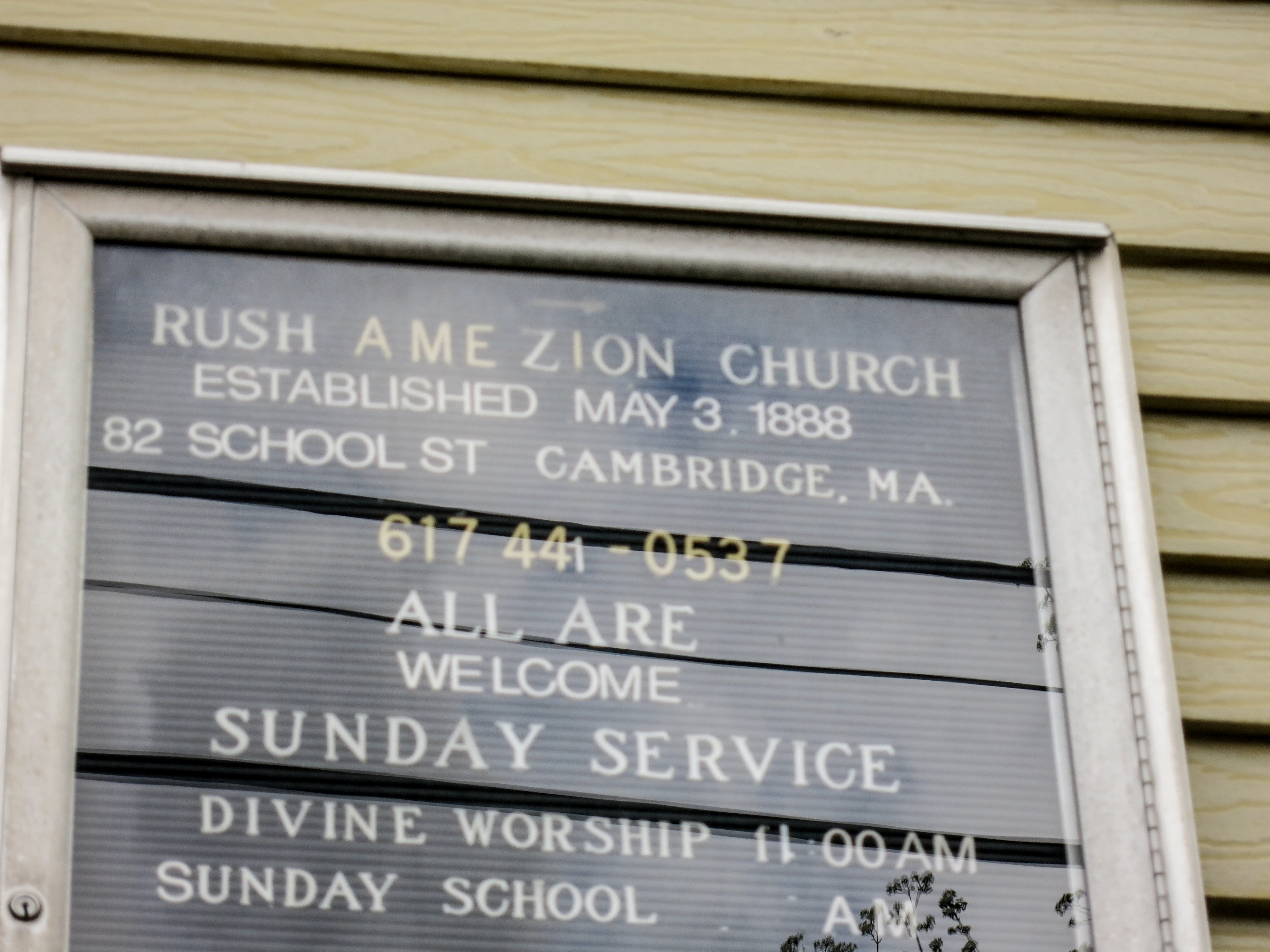 Figure 17: The informational sign
outside of the Rush AME Zion Church. The sign proudly states
that the church was established in 1888 and still continues to
hold services. (Photo by author)
Figure 17: The informational sign
outside of the Rush AME Zion Church. The sign proudly states
that the church was established in 1888 and still continues to
hold services. (Photo by author)
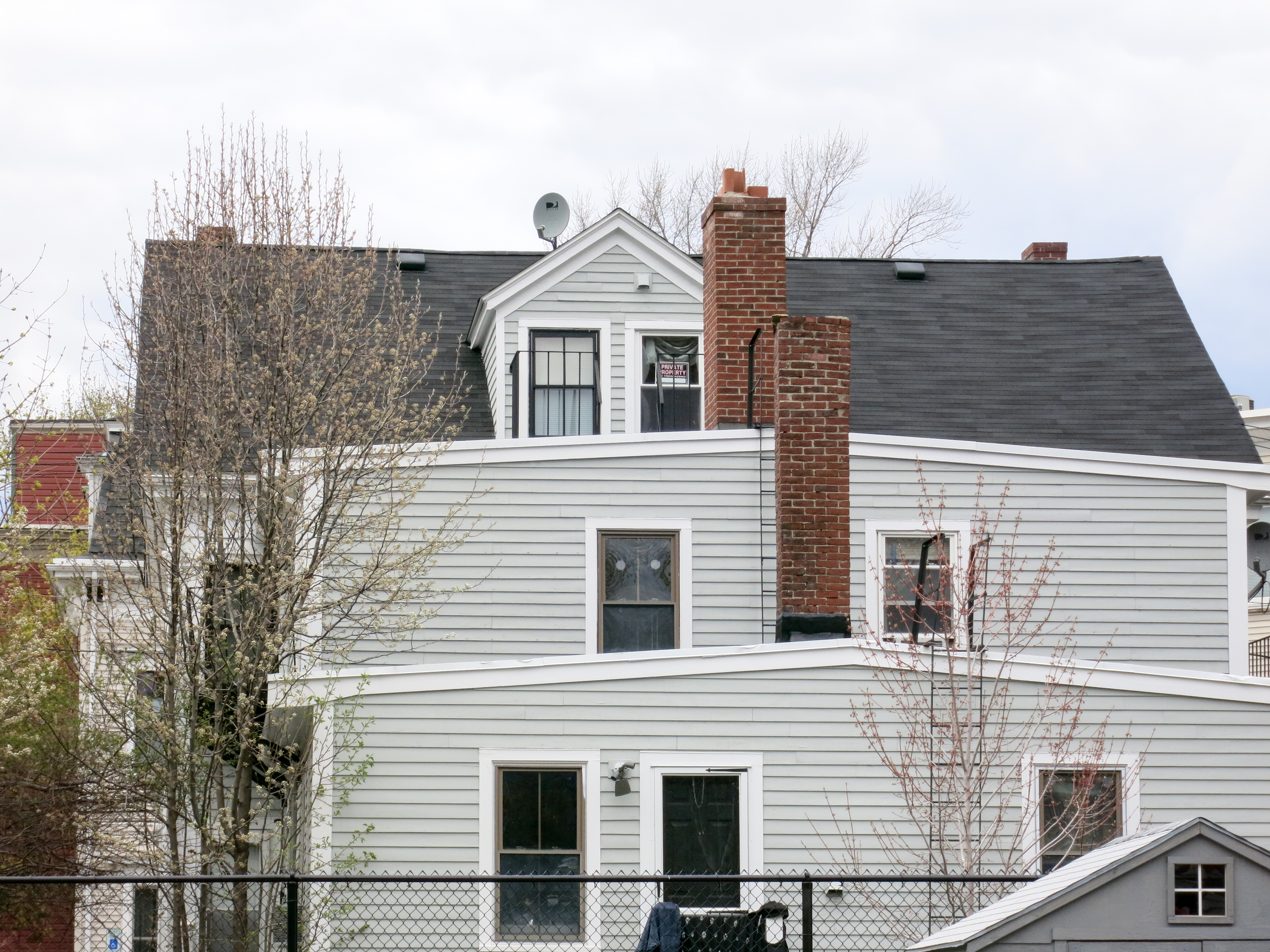 Figure 18: The back of this house
clearly shows that this is a multifamily house. This detail is
backed up by historical map evidence, and it indicative of the
socioeconomic status of the early residents of this area. The
duplex indicates that these people were not upper class or
very wealthy, a detail that further supports the initial
settlement of this area by largely African American
populations. (Photo by author)
Figure 18: The back of this house
clearly shows that this is a multifamily house. This detail is
backed up by historical map evidence, and it indicative of the
socioeconomic status of the early residents of this area. The
duplex indicates that these people were not upper class or
very wealthy, a detail that further supports the initial
settlement of this area by largely African American
populations. (Photo by author)
The ethnic makeup of the site also played an important role in what types of residences were built over time. During the early years, the plots were divided up and many duplex houses were constructed. These houses are distinct in their symmetry, a trait that can be seen in Figure 18. This structure seems to sit on the same building footprint that was originally located on this plot of land (Hopkins 1886). The building was also marked as a multi-family home on the 1886 Hopkins map, like many others on the site as a whole. The socioeconomic position that characterized many African American families during the time of initial development of the site seems to fit in line with both the founding of the churches as well as the size and layout of many of the homes in the area. In this way, most of the buildings on this site serve as artifacts to the trends of cultural identity within its residents throughout time.
Furthering this trend of cultural identity, the Clement G. Morgan Park serves as an artifact of past and present residents. As described by a plaque near an entrance to the park, Clement G. Morgan was a civil rights activist who lived in this area during the late 19th century (Figure 19). The dedication of a place is very telling to the cultural identity of the location. In this case, the existence of a sizable African American population is supported by the naming of the park.
 Figure 19: This plaque at the entrance
to the Clement G. Morgan Park honors the civil rights leader
and provides general information about his life. The decision
of the population to dedicate this specific area to a civil
rights leader is indicative of the interests of the residents
of this area. This provides further evidence for a large
African American population in this site. (Photo by author)
Figure 19: This plaque at the entrance
to the Clement G. Morgan Park honors the civil rights leader
and provides general information about his life. The decision
of the population to dedicate this specific area to a civil
rights leader is indicative of the interests of the residents
of this area. This provides further evidence for a large
African American population in this site. (Photo by author)
Layers: The Ongoing Story
Setting characterized by design decisions of the early years, plot shaped by economic forces on a societal scale, and characters that add identity and personality to the site combine to write the story of this site. Traces and artifacts of the past melt with the present day to create the essence of the site, the feeling of place. Hayden remarks that the term "place" is often far too simplistically described and that the countless factors from the past that shape a location are overlooked. The intertwining of the past and present create layers within the site that often juxtapose periods of history. A prime example of these layers can be seen in Lafayette Square.
In Figures 20 and 21, one can see two views of Lafayette Square with details, artifacts, and traces that span several different historical periods. The earliest traces can be seen in the roads themselves as Massachusetts Avenue and Main Street largely defined the earliest history of the site. Also visible at this location is the previously mentioned Union Baptist Church, one of the oldest in this area, and the U-Haul with visible evidence of its earlier role as a garage during the mid 20th century. The more recent layers visible on this site range from the benches and landscaping completed in 2008 to the plastic, ice cream-covered spoons that litter the ground from earlier that day.
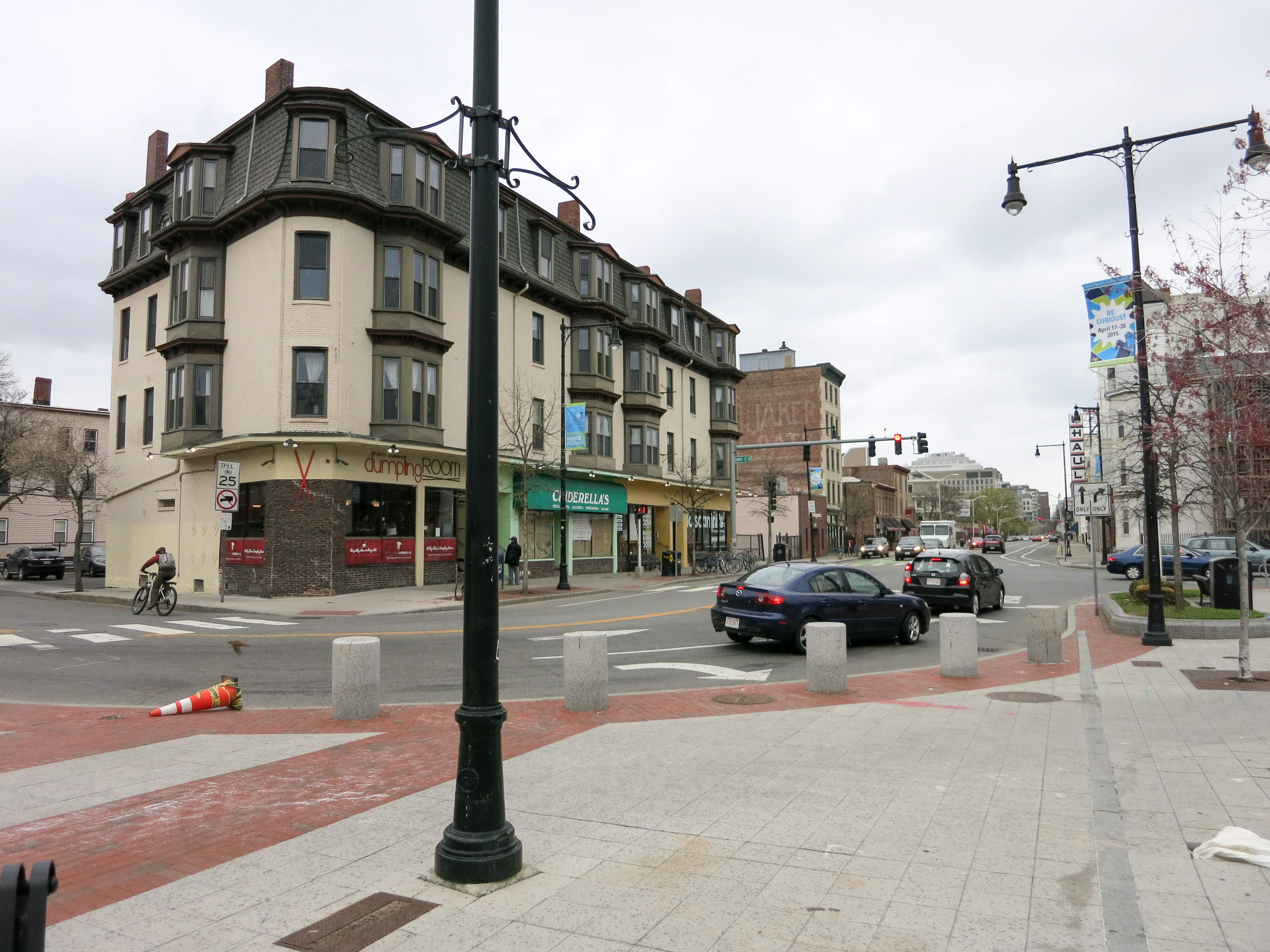 Figure 20: The view down Main Street
shows the Union Baptist Church and the U-Haul in the
distance. Additionally, a relatively new ice cream shop has
taken root on this street corner. The current site is directly
composed and influenced by the past. (Photo by author)
Figure 20: The view down Main Street
shows the Union Baptist Church and the U-Haul in the
distance. Additionally, a relatively new ice cream shop has
taken root on this street corner. The current site is directly
composed and influenced by the past. (Photo by author)
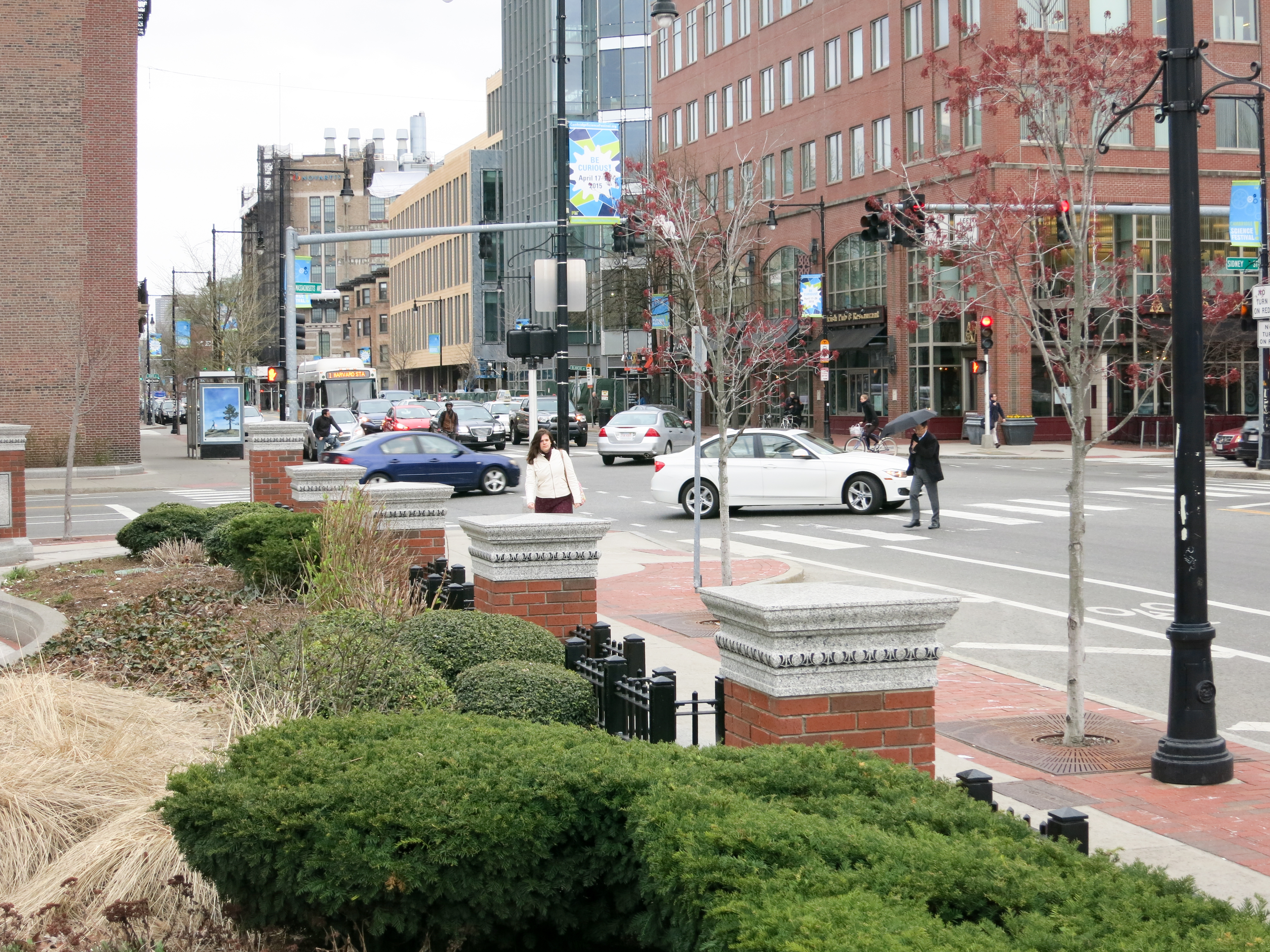 Figure 21: The view looking down
Massachusetts Avenue shows both the road itself, one of the
oldest traces on the site, and the landscaping found within
Lafayette Square, one of the newest additions to this
location. (Photo by author)
Figure 21: The view looking down
Massachusetts Avenue shows both the road itself, one of the
oldest traces on the site, and the landscaping found within
Lafayette Square, one of the newest additions to this
location. (Photo by author)
Each of these layers contributes to the current state. The location is truly a sum of the past, and the story of this site is ongoing. By examining the trends that have shaped the site into the current urban form, it is not unreasonable to speculate about the future of this location. The initial design decisions had great influence on the site, but their effects are now largely known. However, the societal forces that shaped the site's rise and fall as a suburb and the cultural identity of the residents are still at work. These trends hold the key to what the future of this site will be.
Looking for evidence of changes in these trends reveals a dynamic future. Figure 22 shows the Rush AME Zion Church, though looming in the background are the behemoth structures that house the biotechnology firms growing in this area. This industry has yet to make the leap onto the site, but the societal trend towards high tech industry may soon bring a very different feeling to the site. With reference to the residents themselves, both the artwork in Lafayette Square and the existence of the the Concilio Hispano (Figure 23) note the increasing numbers of other ethnic groups in this area. The diversification of the population may lend itself to a change in the trends brought about by the cultural identity of the site.
 Figure 22: Beyond the Rush AME Zion
Church, one can see the tops of biotechnology giants who have
moved into locations along Massachusetts Avenue. In the next
several years, will expansion drive new industry into the
site? (Photo by author)
Figure 22: Beyond the Rush AME Zion
Church, one can see the tops of biotechnology giants who have
moved into locations along Massachusetts Avenue. In the next
several years, will expansion drive new industry into the
site? (Photo by author)
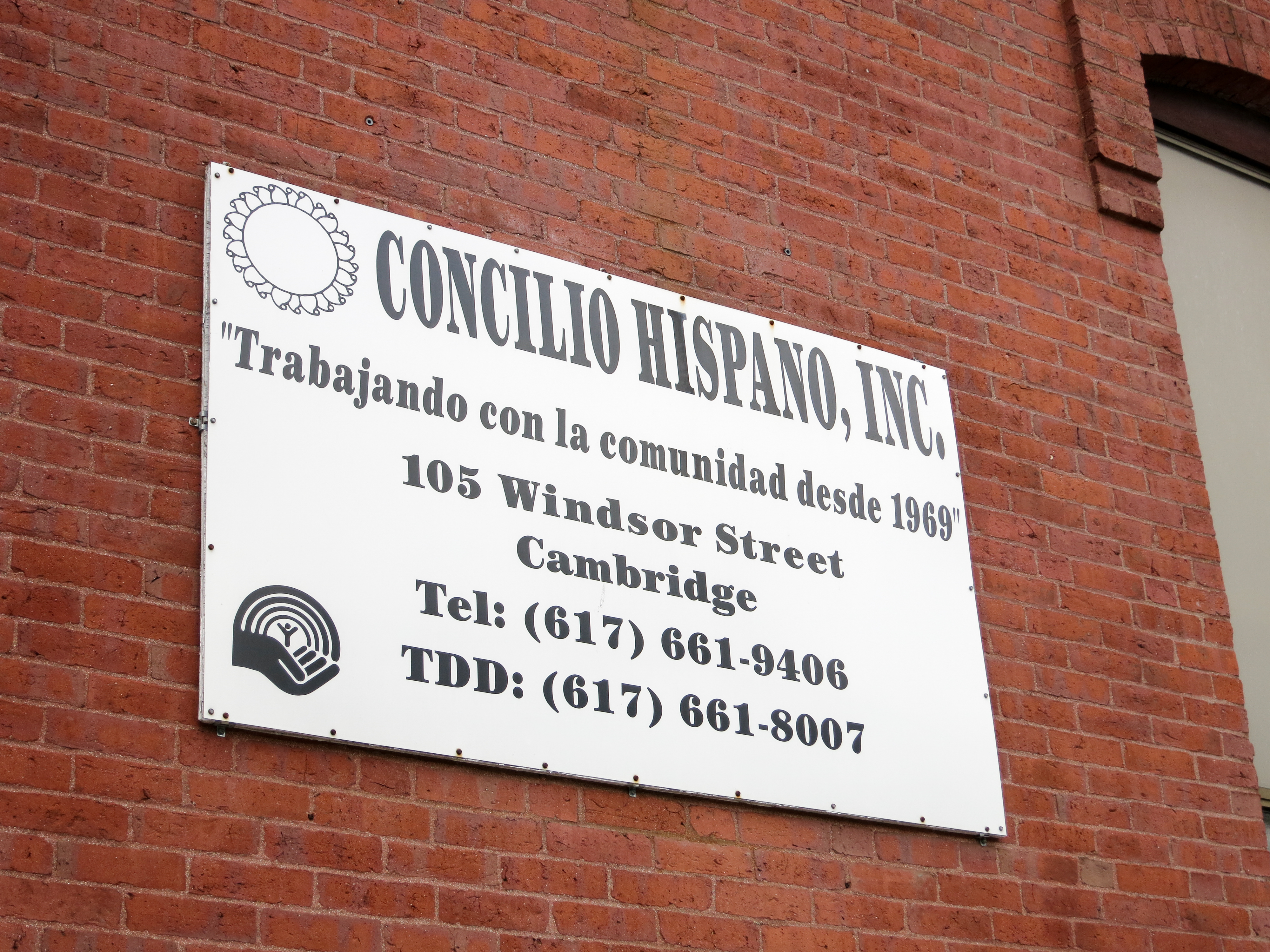 Figure 23: This organization has been
working within the community since 1969. This indicates a
shift in the cultural makeup and identity of the residents of
the site. Will this create dramatic change in the future?
(Photo by author)
Figure 23: This organization has been
working within the community since 1969. This indicates a
shift in the cultural makeup and identity of the residents of
the site. Will this create dramatic change in the future?
(Photo by author)
In her book, The Language of Landscape, Anne Spirn writes of a practical value to understanding the manner in which a site can speak (Spirn 1998). To the untrained eye, the city can seem one dimensional, a collection of materials at a particular place in time. Yet, examination of these artifacts, in the context of the natural processes that persist and influence the location, can reveal a rich story of what a place was, is, and will be. In the context of this site, the culmination of location, society, and individuals creates a multilayered and intertwined story of place. This story is one to be appreciated for its history and enjoyed in the present, but also to very practically be consulted when planning for the future.
Anne Spirn (1998). The Language of Landscape. Thomson-Shore, Inc.
Bromley, G. (1916). Atlas of the city of Cambridge. Harvard University Library Archive.
Bromley, G. (1930). Atlas of the city of Cambridge. Ward Maps LLC.
Firefighters, C. (2009). Cambridge Firefighters Local 30. Retrieved from http://www.cambridgelocal30.org/ on April 25, 2015.
Hastings, L. M. (1919). Cambridge Highways. Ward Maps LLC.
Hayden, D. (1995). The Power of Place: Urban Landscapes as Public History. The MIT Press.
Historic American Engineering Record (1968). Harvard Bridge, Spanning Charles River at Massachusetts Avenue, Boston, Suffolk County, MA. Library of Congress Engineering Records.
Hopkins, G. (1873). Atlas of the city of Cambridge, Massachusetts. Harvard University Library Archive.
Hopkins, G. (1886). Atlas of the city of Cambridge, Massachusetts. Harvard University Library Archive.
Mason, W. (1861). Map of Cambridge, Mass. Boston Public Library.