Introduction
There are only a number of characteristics left from the Boston of the beginning of the nineteenth century. In the last two hundred years, several factors have led to significant changes in land use, architecture, road patterns, and demographic composition of the Boston area. As a historical landmark, the area of Beacon Hill stands as one of the few locations in Boston that have survived the trends and processes set by industrialization and urban renewal. Even though neighboring areas to Beacon Hill like the West End or the downtown have underwent important changes in the last century, the area around Louisburg Square remain mostly unchanged: small single-family rowhouses and narrow streets and alleys. As a result, by exploring the settling patterns, changes in land use, and demographics of the area we can understand how different events in the history of Beacon Hill and surroundings have led to such divergent change patterns over time.
Settling of Beacon Hill and Demographics
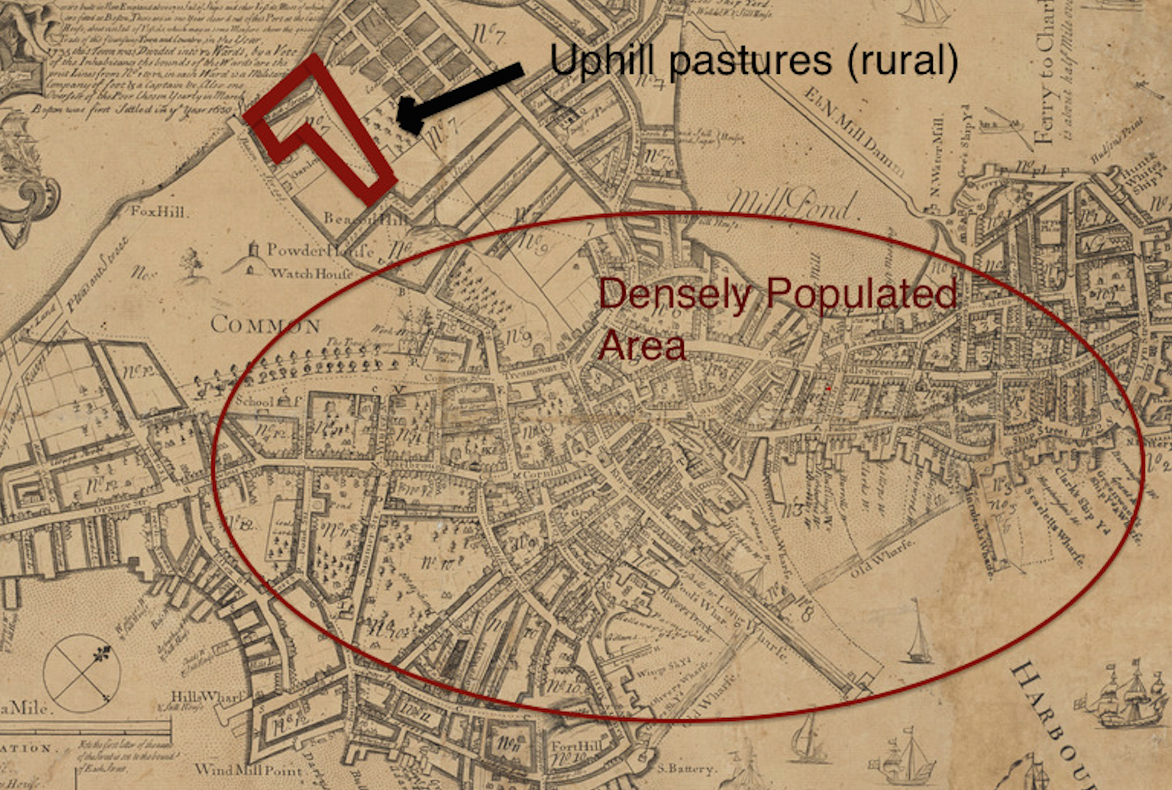 Figure 1: Map from the Norman B. Leventhal Map Center: Plan of Boston to the year
 1769. Boston’s population centroid was initially located on the harbor side, while Beacon
Hill was considered a rural area. By the 19th century, wealthy families settle in this
pleasant hill-side area with Greek revival architecture row houses.
Initially, Boston’s settling occurred mostly around the harbor shore, while the area facing the Charles River was mainly composed rural pastures and green areas (including the Common). As seen in Figure 1, the area originally composed of the Tri Mountain (Beacon Hill, Mount Vernon, and Pemberton Hill) wasn’t formally settled, partly due to the mountainous geography and distance from the harbor itself (which back then must have been the center of economic activity). However, the reduction of the Tri Mountain and construction of the State House set the trend to future settling of Beacon Hill in the nineteenth century. As described by Warner in Mapping Boston, “the new mercantile wealth transformed the city in a rush of public works […] everywhere the city pushed outward”[2]. Hence, the initial settling of Beacon Hill occurred as a result of the growing economic activity, leading the wealthy to move out to the outskirts of the city while the lower and middle class remained in the industrialized and crowded downtown area [1]. Indeed, the economic spring of Boston in the early nineteenth century characterizes an important phenomenon of ethnical division and settling. Solely in Beacon Hill, the South slope, composed mainly of mansions and rowhouses developed by Charles Bulfinch, attracted the wealthy upper class Bostonians, while African Americans principally settled the North Slope.
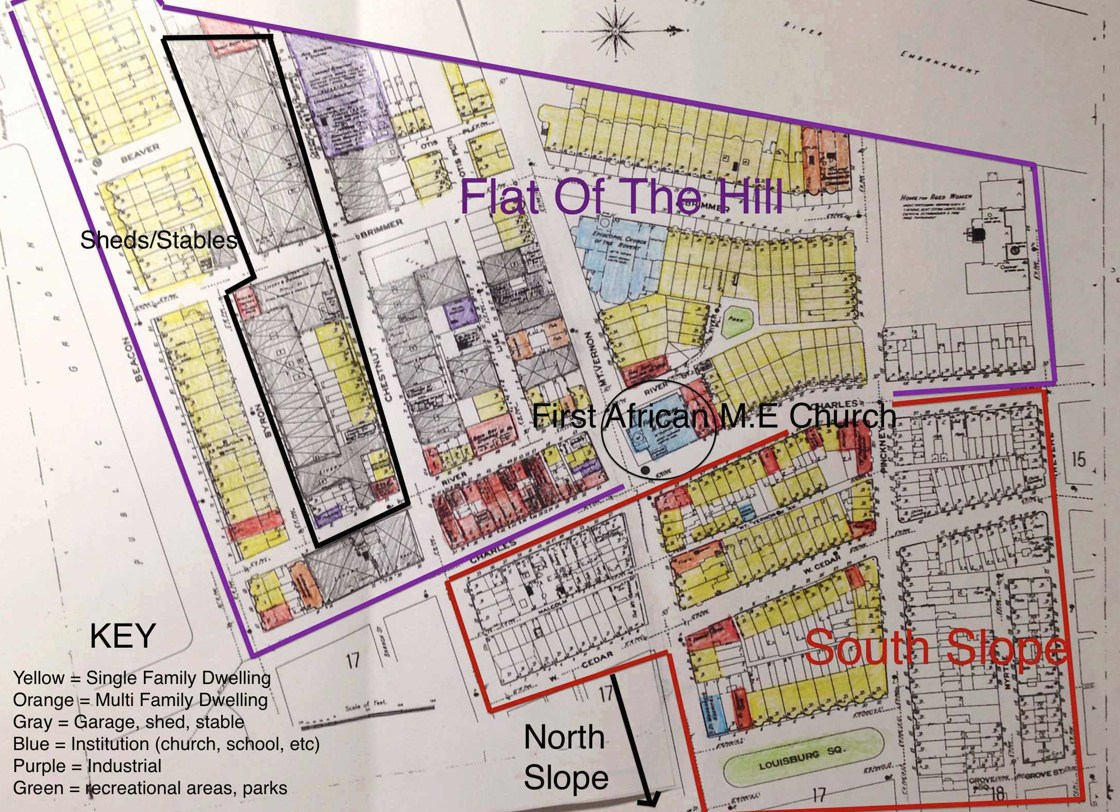 Figure 2: Sanborn Fire Insurance Map from 1909, Plate 14. The presence of the First
African Methodist Episcopal Church Suggests the importance of African American
population in Beacon Hill (particularly the North Slope). Initially, we see residential
predominance in the South Slope while the Flat of the Hill already has many sheds,
stables and commercial lots replacing residences.
The African American presence becomes significant if we look at some clues that several maps give us. For example, as seen in Figure 2, by 1909 you see the First African Methodist Episcopal Church in the corner of Mt. Vernon and Charles Street. However, by 1951 this church is replaced by the Charles Street Universalist Meeting House. This change confirms Warner’s argument: “the African American community, first settled on the north slope of Beacon Hill in modest wooden houses, was displaced by speculators who built five story brick tenements for the new immigrants pushing up from the West End flats” [2]. This displacement process furthermore augments the development of Beacon Hill as an exclusive neighborhood. By the turn of the twentieth century, the original settlers of the North Slope were being displaced to construct multi-family dwellings for immigrants. In fact, this speculative process of replacing single-family homes with commercial stores and apartments became a trend in Boston in the early twentieth century as a result of the rise of the upper middle class [1].
Single Family Row Houses
By looking at an 1867 map (Figure 3) of Beacon Hill we can observe the predominance of single-family dwellings (yellow) throughout the area. The south slope in particular was planned and built with small single-family row houses after the reduction of the Tri Mountain. As described by Jackson, row houses became the preferred house choice for wealthy Americans in the nineteenth century due to the “hostile view of nature and because public transit was either lacking entirely or uncomfortable and slow” [1]. Furthermore, Jackson describes their view of nature as caused by Puritan beliefs which thought of wilderness and dark as devil related. Therefore, this tight knit community of row houses became a characteristic element of Beacon Hill’s south slope, while areas surrounding the area (like the flat of the hill or the West end) developed different architectonic trends and land uses.
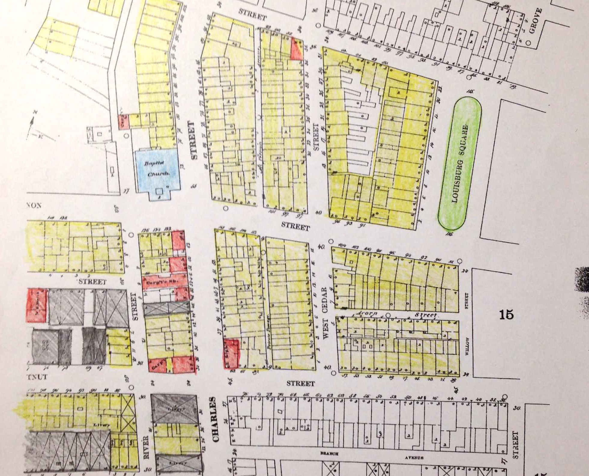 Figure 3: Sanborn Fire Insurance Map from from 1867, plate 14. By the later half of the
nineteenth century, small row houses were predominant in the area of Louisburg Square,
reflecting the Puritan beliefs of having houses immediately next to each other.
Regardless of the time frame selected, the maps of Beacon Hill depict clear contrasts between the land uses of the area of the south slope and surrounding blocks. For example, by looking at the map of 1909 in Figure 2, the contrast between section 1 and section 3 are notorious. The first impression is the amount of gray in section 3, representing sheds and stables. Even though most of the families living in section 1 had horses or some sort of transportation, the Puritan philosophy described previously avoided the sheds and stables from being located in this area. Also, the presence of workshops, factories, and shops in section 3 might lead to lower land costs in this area, making it affordable to have sheds and stables. Furthermore, the size of the lots and blocks in sections 2 and 3 are considerably greater compared to those in section 1. Thus, this suggests the importance of the initial structure of the south slope and how its initial resistance to change has helped it maintain its historical essence in the last one hundred years.
The Car and the Commercialization of Charles Street
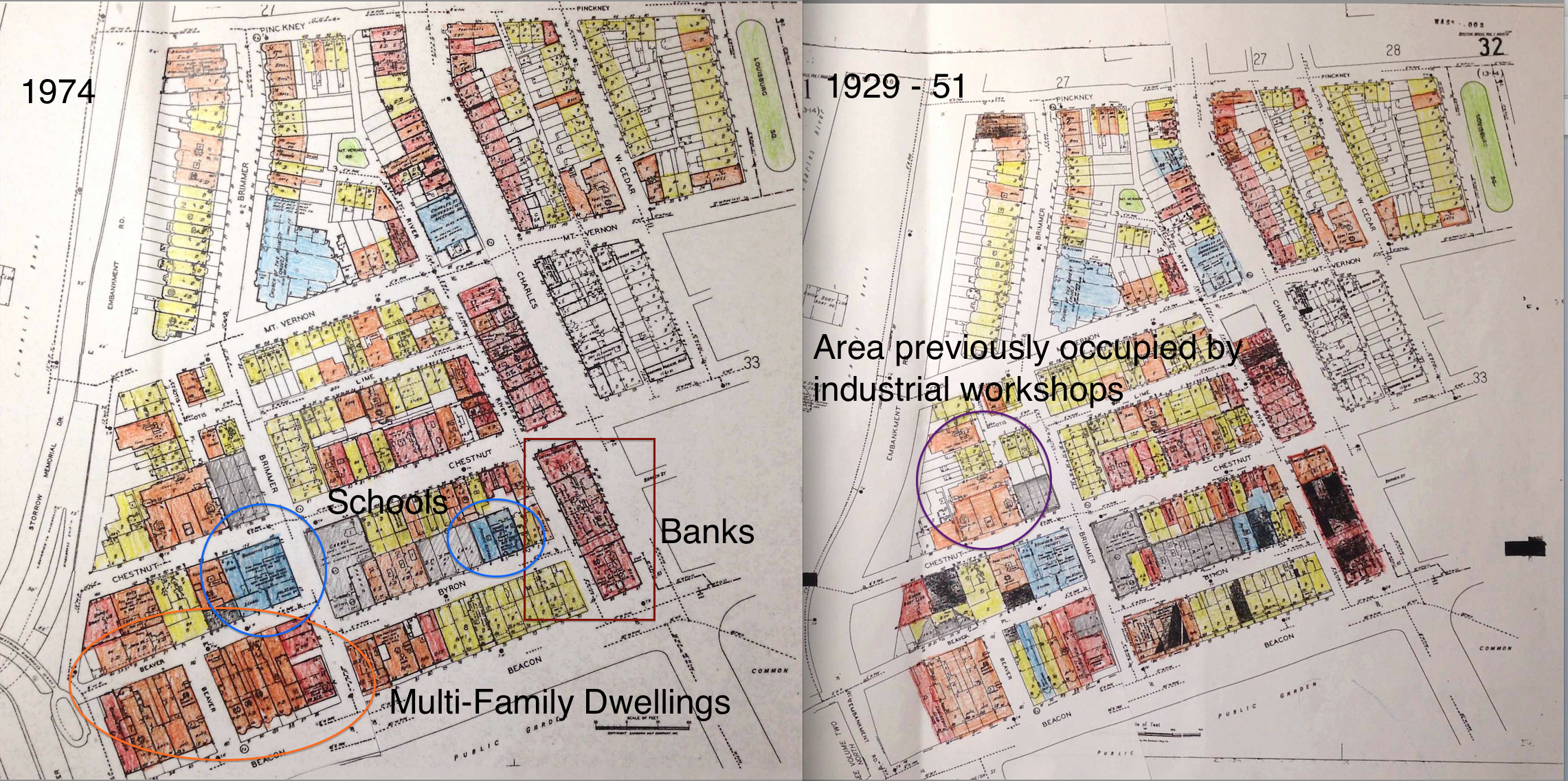
 Figure 4: Sanborn Fire Insurance Map from 1929 – 1951, plates 32 and 33. During this
period of time the flat of the hill faces several changes due to the appearance of the car.
The displacement of industry to the suburbs leads to the construction of apartment
buildings and commercial stores in the area. Also, garages replace the lots previously
occupied by sheds and stables.
By the twentieth century, several historical events like the appearance of the car, the Great Depression, and urban renewal trends challenge the historical essence of Beacon Hill. By looking at the 1929 – 1951 map in Figure 4 one can notice several significant changes due to some of this events: displacement of industrial units, replacement of sheds and stables with garages and parking lots, construction of flats and apartment buildings, and the development of Charles Street as a commercial area.
Structurally, the car didn’t have much effect in Beacon Hill besides the fact that parking lots and garages replaced stables. However, the car initiated a critical suburbanization pattern in the Boston area, which led to several residential units in central Boston to be replaced by commercial units. In fact, looking at Charles Street in the map of 1909 and 1929 – 1951 depicts this pattern. Also, the development of large roads to suit the car leads to the appearance of the Embankment Road in the shore of the Charles River. The appearance of this road, providing fast access to the houses in the Flat of the Hill, increases the land value and population of this area, resulting in the development of apartment buildings in the area. Furthermore, the car leads to the displacement of the industrial units seen in the 1909 map to the suburbs. As described by Jackson, “as early as 1963 […] about two thirds of all manufacturing activity took place in the “industrial parks” and new physical plants of the suburbs” [1]. Thus, by displacing industrial activity, these lots were replaced by offices, restaurants, clubs, schools, and flats. Specifically, by comparing the 1909 and 1929 – 1951, we can see how the purple area previously occupied by automobile workshops, repositories, and factories was replaced with immense apartment buildings and garages. Therefore, even though the car didn’t have any direct effect in the shaping of Beacon Hill in the early twentieth century, it provoked several trends that ultimately left several changes in the land composition of this area.
Flats and Apartment Buildings
As explained in previous sections, multi family dwellings start to replace single family towards the end of the nineteenth century as a speculative economical incentive of those who aimed for the rise in real state costs in Beacon Hill. However, the Great Depression and post-World War II baby boom enhanced this process in the first half of the twentieth century. As described by Warner, during the Great Depression “the well-to-do abandoned their houses in the Back Bay, the Fenway, and Beacon Hill, some moving into old summer homes in nearby suburbs. Their places in the city were taken by physicians offices, small efficiency apartments, and student digs” [2]. By looking at the 1929 – 1951 and 1974 maps (Figure 5) we can see how orange multi family dwellings substantially replace yellow single-family lots. Particularly in the area of the flat of the hill and the blocks facing Beacon Street, we see a high density of apartment buildings and offices (represented by some of the red lots). Furthermore, as factories in the central cities were replaced with banks, hospitals, clubs, and offices, the higher middle class working in these settled in the multi family dwellings in the Flat of the Hill. As seen in the 1974 map from Figure 5, schools, college buildings, and banks (as noted in the map) start appearing in the blocks in the Flat of the Hill bordering Beacon Street. Thus, the Great Depression and post World War II time frames enhance an economical change in the Flat of the Hill as the wealthy move to the suburbs and upper middle class populated the apartment buildings. However, regardless of these multiple factors of social and economical changes happening in Boston, the area of the south slope (Louisburg Square) remained unchanged.
Urban Renewal vs. Historical Preservation
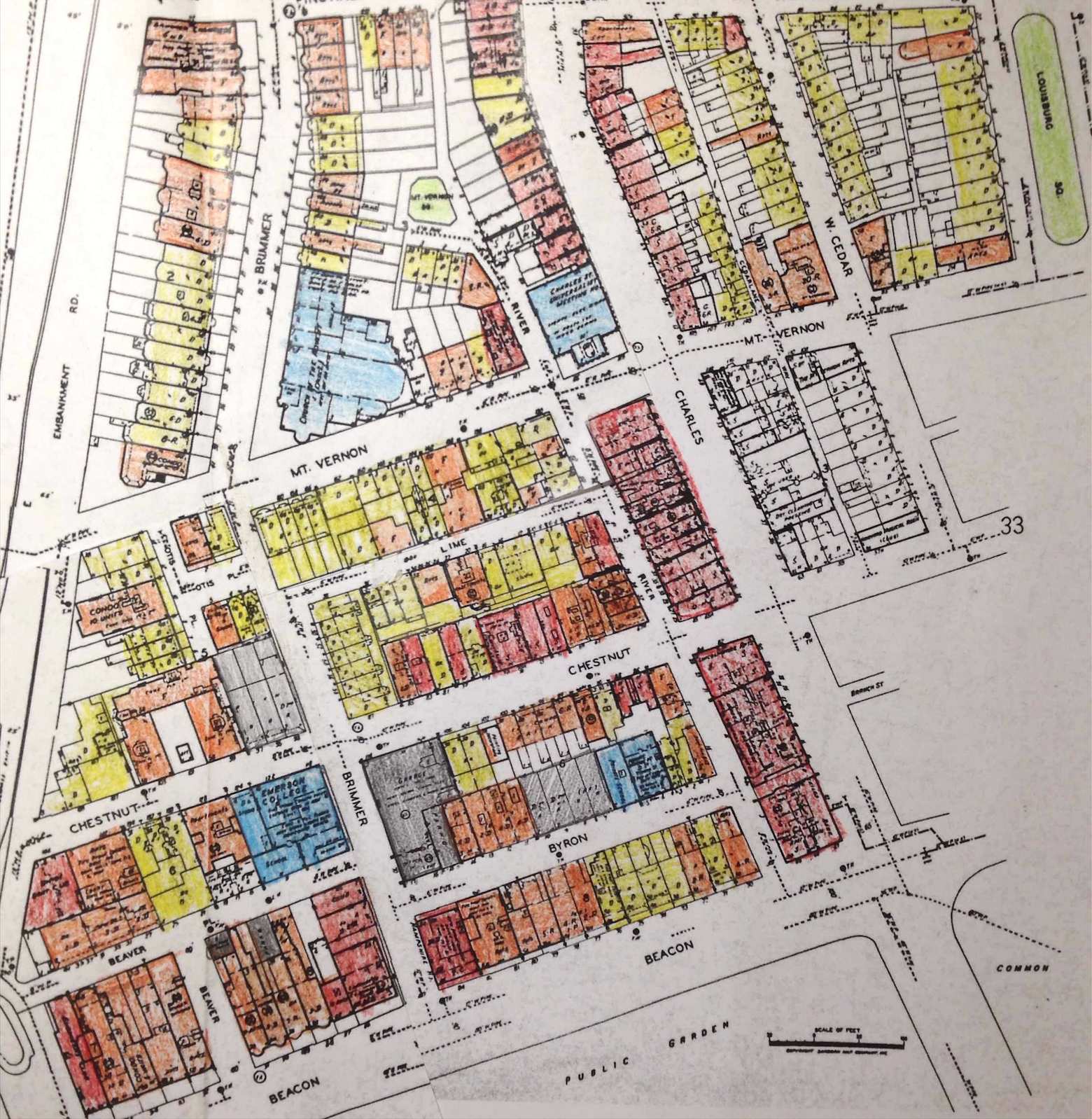 Figure 6: Sanborn Fire Insurance Map from 1992, plates 31 and 32. While the flat of the
 hill underwent substantial changes between 1867 and 1992, the area around Louisburg
Square remained almost unchanged.
One of the most significant insights of looking at the maps of Beacon Hill between 1867 and 1992 is the diverging changing processes occurring in different areas. As noted previously, the area of Louisburg Square remained as a tight knit neighborhood of joint row houses due to the underlying Puritan culture present in its settling. By the twentieth century, one must expect the high renewal forces to take over this little historic district, especially if adjoining areas are being completely transformed by the urban renewal processes. Still, Louisburg Square remained the same: the yellow-colored single-family dwellings are predominant in this area in the maps of 1929 – 1951, 1972, and 1992 (Figure 6). Why is this happening? Initially, the geography of the hill and the narrow streets in the area form a natural barrier from the forces of urban renewal. Furthermore, the population profile of the people in the south slope hadn’t changed much since the nineteenth century (they were still the wealthy Bostonians), and thus exerting no need for structural alteration. On the other hand, we find a common driving factor in the areas that underwent urban renewal: changes in demographic composition, population profile, and immigrants. As seen in the Flat of the Hill, the construction of the Embankment Road, the development of Charles Street as a commercial line, and the replacement of factories by offices impulse this change in population profile from wealthy single-family home owners to upper middle class workers and students. Similarly, the North Slope sees this renewal change when the immigrant population from the West End displaces the African American population. Thus, urban renewal forces appear in areas that have already been affected by historical events (the appearance of the car, the Great Depression, or the baby boom). On the other hand, Louisburg Square, completely alienated from all these phenomena, preserves it historical essence despite the urge for renewal and modernization in Boston.
Conversely, the urban renewal trend also spawned a preservation movement. Just as it happened with industrialization and environmentalism, the rapid urban changes happening in Boston ignited the sentiment of preservation of historical landmarks. As a result of this, the area of Beacon Hill (observed in Figure 7) was designated a Historic District by 1955, in the midst of post World War II renewal movements [3]. Taking this into account, by exploring the maps we can observe a halt in the renewal trend happening in the Flat of the Hill by 1955. As seen in the maps between 1909 and 1951, most of the single-family dwellings and factories became apartment buildings, offices, stores, banks, and schools. However, in 1972 and 1992 the land composition of the area remains unchanged. While urban renewal projects in the second half of the twentieth century completely re-shaped areas like the West End, Beacon Hill remained unchanged to its denomination as a historic district. As a result of this, we can observe a clear dichotomy between these two areas: West End as the embodiment of a district reformed by urban renewal, and Beacon Hill as an epitome district, symbolizing the historical essence of Boston.
Conclusion and Connecting the Dots
Observing the Flat of the Hill and the South Slope of Beacon Hill change over time provides insight to drawing mayor conclusions about several changing patterns and forces that have driven this change. Besides the rather explicit events that have shaped the form of the city in the last two hundred years, there is a primordial factor that characterizes the core of these patterns: demographics. As seen in Beacon Hill and its surroundings, the change in population profile caused by displacement and immigration initiated the process of urban renewal. In fact, by renewing the type of people who populate a specific block we are renewing its culture, and as a result, its structure and architecture. We are taking off churches and African meeting houses and building synagogues; we are taking off factories and small wood homes and building offices, apartment buildings, and clubs. In other words: we are changing the essence of this area. This is what happened in my site, and in a greater extent in the West End: the city renews to accommodate the predominant demography, be it students, low class workers, businessmen, or wealthy homeowners. Meanwhile, in Louisburg Square, the essence remained the same. The once Puritan-oriented row house neighborhood survived the twentieth century because the people living in these houses were always the same people: the wealthy Bostonians who at the beginning were able to afford a Greek revival row house. Looking at the big picture, population is the biggest changing force in a city. The population adapts to the changes posed by historical events and further shapes the environment it settles in by instilling its culture. In the end, the city becomes a composition of these districts shaped by their demographic composition and population profiles. And that’s why, in 2014, Louisburg Square is still the same as in 1867.
References
[1] Jackson, Kenneth. Crabgrass Frontier: The Suburbanization of the United States. Oxford, 1985.
[2] Warner, Sam B. Mapping Boston, edited by Alex Krieger. Cambridge, MA: MIT Press.
[3] “Beacon Hill,” City of Boston, accessed April 3, 2014, https://www.cityofboston.gov/landmarks/historic/beaconhill.asp