Looking at the marshlands that completely covered my site in 1854, one could hardly have imagined that this same site would grow to be the biotechnology hub that it is on the verge of becoming today. At $66.63 per square foot in the southern part of my site, Kendall Square is currently one of the most costly pieces of office land in the US. Office rents are poised to increase as office space is quickly snapped up and demand for more office space grows. Changes across maps of my site from 1854 to 2015 trace the development of this site from marshlands, to an industrial area, and finally to a strategic location for biotechnology companies. The paper looks at the catalysts for this process over the period of 160 years, from 1854 to 2015.
1854: Marshlands and Suburb
The earliest developments in East Cambridge were a residential area and a train station. To the immediate south of the residential area were tidal marshes, and to the north, a creek and a train station. The tidal marshes were bordered by Broad Canal, which was dug in 1810 . The residential area was largely separated from the rest of Cambridge, and relied on major streets for transport to and from more developed areas. Figure 1 shows one of the major streets in question: Court Street for transport to Cambridgeport. To the north, Cambridge Street connected my site to Harvard and Central Cambridge. To the east, Craigie’s Bridge provided road transport to Boston. The proximity of the train station to the residential area is significant, because the presence of the station likely catalyzed the development of the residential area on this site. The site could otherwise be said to be undesirable for habitation, by measure of its distance away from shops, factories and other more developed sites. The residential area grew as marshlands were filled in and an industrial zone developed south of the site, in the vicinity of what would later become Kendall Square.
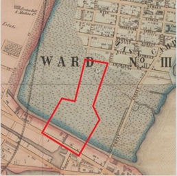 Figure 1: Map of East Cambridge in 1854. Red Polygon delineates the boundaries of my site. Broad Canal cuts across my site, which at this time is still largely tidal marshes. Kendall Square is the area south of Broad Canal to approximately Main Street. Map by H.F. Walling, Civil Engineer for the City of Cambridge.
 The East Cambridge residential area likely developed as a kind of suburb to Boston. The same cannot be said of the rest of Cambridge, particularly Old Cambridge, where the town was centered on Harvard University. The mansions of Tory Row, among other prominent buildings, are located in Old Cambridge. However, East Cambridge is sufficiently displaced from Old Cambridge that it is closer to Boston, with easy commute between Boston and East Cambridge via Craigie’s Bridge. It is therefore very likely that the residential area that came to be in East Cambridge developed to house people who needed to travel to Boston for work. This later changed as the area south of East Cambridge developed and attracted various factories and industries. The industrial development of the southern part of my site, around Broad Canal, would have driven up demand for manual labour and workforce around my site. The proximity of the residential area to the growing industrial zone made it lucrative for developers to further expand the residential area.
Broad Canal drives Industrialization
Broad Canal used to cut through my site, as illustrated in Figure 1. It had a significant effect in shaping the industrial nature of my site, so it doesn’t come as a surprise that its eventual destruction consequently moved the industries away. While the Broad Canal was dug before 1810, the industrialization of the area neighbouring the Canal took a little longer to evolve. The marshlands first had to be converted into usable land. This was done between 1854 and 1903. By 1903, the land on either side of Broad Canal had been fully developed and was completely occupied by lumberyards, rubber companies and coal yards. Broad Canal likely provided cooling, fire safety and transport for these industries. Figure 2 shows a 1903 map of the industries neighbouring Broad Canal. The industrial nature of the land around Broad Canal remained largely unchanged until the 1910s, although the individual factories around the canal did change.
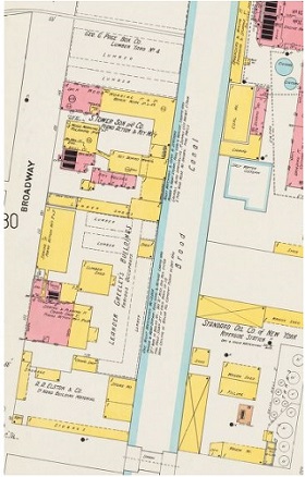 Figure 2: 1903 Map of area bordering Broad Canal. A lumber yard, a coal company and the American Rubber company straddled Broad Canal. Map from Sanborn Fire Insurance Maps, 1903.
 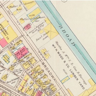 Figure 3: 1913 Map of area bordering Broad Canal. Nature of factories remained largely unchanged, although some factories have been replaced. Lumber yards and coal companies still present. Map from Bromley Atlases. G.W. Bromley and Co.
 Between 1913 and the 1960s, several big changes happened around my site, leading to a change in the type of industries that were located on my site. Industries that relied more heavily on water transportation moved away and were replaced by industries that were ostensibly more concerned with easy access to water. On closer look, the nuanced change of the type of industries that bordered Broad Canal provides some insight onto the infrastructure developments in the greater Cambridge and Boston areas. In 1906, the Charles River Dam, officially named Craigie Dam, was completed upstream of the Charles River . The Charles River Dam Drawbridge, officially Craigie Bridge, was subsequently completed in 1912. A lock was placed on the Charles River Dam Bridge to allow for the different levels in water across the bridge. Smaller ships could utilize the lock mechanism to traverse across the bridge, but bigger ships required the opening of the drawbridge .
The dam and the bridge effectively bottlenecked water lanes leading into Broad Canal, at a time where water transport accounted for a large portion of cargo transport. The age of the automobile was in its infancy in 1910, and mass manufacturing of automobiles was just beginning. (Jackson, 1985). The industries that relied more heavily on cargo transport such as the aforementioned lumber and coal yards, as well as rubber factories, no longer benefitted from being located right beside the canal. Other industries that prioritized cooling and fire safety and did not rely as much on water transport, such as manufacturing companies and foundries, took the places of these industries. However, in a 1930 map (Figure 4), the number of factories around Broad Canal was noted to have decreased and there were areas of undeveloped land. The decline in the number of factories could possibly be attributed to the Great Depression . Oil companies continued to reside north of Broad Canal, but the number of factories south of Broad Canal on my site has dwindled.
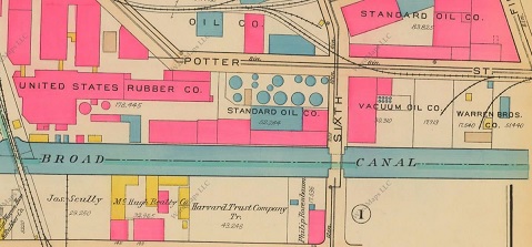 Figure 4: 1930 Map of area around Broad Canal in East Cambridge, between Broadway and Potter. Number of factories south of Broad Canal has declined. Oil and rubber companies still largely present north of Broad Canal. Map from Bromley Atlases, 1930.
 By 1950, the oil companies had also moved away. Manufacturing companies took their places, but not for long. Figure 5 shows a map of the industries around Broad Canal in 1950. The previous lumber and coal factories have been replaced by manufacturing factories. The change in the type of industry occupying the land beside Broad Canal was likely due to the water transport limitation imposed on Broad Canal by the Charles River Dam. Manufacturing factories did not prioritize cargo transport as heavily as did the lumber and coal factories. By the 1960s, the truncation of Broad Canal had been initiated. Figure 6 shows partial filling of Broad Canal on my site in 1970. Broad Canal was gradually filled in, part by part, until it lay just short of Third Street in 1996. Heavy industries started to migrate away from my site. The filling of Broad Canal, which was most likely the primary pulling factor for heavy industries, gave those same industries no reason to stay. The southern part of East Cambridge was largely industrial up to this point. The sudden emigration of the heavy industries left East Cambridge with large vacant lots and abandoned factory buildings. The influx of vacant lots likely presented an opportunity for research laboratories to move into East Cambridge, post-1960s.
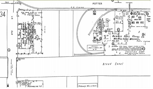 Figure 5: 1950 Map of area around Broad Canal. The previous lumber yards and coal companies of 1913 have been replaced by a road-paving factory, an electric & neon signage factory and a photoswitch manufacturing company. Map from Sanborn Fire Insurance Atlases, 1950.
 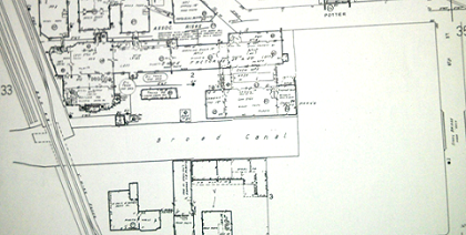 Figure 6: 1970 Map of my site around Broad Canal. Broad Canal has been partially filled. Large vacant lots are seen as factories migrate away. Map from Sanborn Fire Insurance Atlases, 1970.
MIT as a Research Hub
The Massachusetts Institute of Technology (MIT) moved into Cambridge in 1916, about half a mile south of my site. MIT’s presence probably contributed to the rapid industrial development on my site. The truncation of Broad Canal post 1970 and the resulting gap left from factories leaving allowed for research laboratories to take up the space. Various laboratories moved onto my site between 1970 and 2000, presumably to be closer to MIT’s research, and possibly to facilitate collaboration with MIT.
In the 1960s, the National Aeronautics and Space Administration (NASA) attempted to base some of its operations in East Cambridge, purchasing at least 5 plots of land to build on. Several NASA buildings can be seen in a 1970 Sanborn Map in Figure 7. NASA opened the Electronics Research Center (ERC) in 1964, amidst political controversy over its funding. The ERC was eventually shut down after multiple NASA funding cuts, and was relocated to Houston, Texas. NASA’s presence on my site was thus cut short, and created vacant lots that largely remained on my site until 1996. Figure 8 shows an increase in vacant lots from 1970 to 1996. The Department of Transportation later took over a few of the largest sites, one of which remains the United States Department of Transportation's John A. Volpe National Transportation Systems Center. The Volpe National Transportation Systems Center is located on the southeast quadrant of my site.
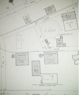 Figure 7: 1970 Map of site centered on previous location of Broad Canal. The circular building on Munroe Street, as well as the neighbouring buildings south of Potter Street are owned by NASA. NASA’s Electronics Research Center (ERC) building is the southernmost building. Map from Sanborn Fire Insurance Atlases, 1970.
 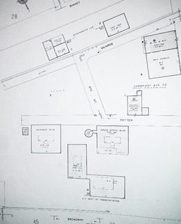 Figure 8: 1996 Map of site centered on previous location of Broad Canal. The circular building seen in Figure 7 has disappeared, along with several nearby buildings. The ERC building has been replaced by a US Department of Transportation building. Map from Sanborn Fire Insurance Atlases, 1996.
Between 2000 and 2015, the biotechnology industry grew tremendously in East Cambridge. East Cambridge has effectively become a hub for biotechnology companies, comparable to what Silicon Valley is for technology companies. The close location of Kendall Square to MIT, in addition to its relative vacancy in the 1990s, has likely enabled startups by MIT graduates and professors to be based here. As these startups mature, bigger pharmaceutical and biotechnology companies buy them, and then, rather than move away, continue to establish a base in East Cambridge. Novartis, a European pharmaceutical company, has a prominent presence in Central and Kendall Square, and is in the process of constructing more buildings in the area. Other notable biotechnology companies in the area include Biogen Idec, Genzyme and Broad Institute. Moreover, the proximity to MIT enables these biotechnology companies to be closer to the research done at MIT, and dip into the hiring pool of fresh graduates from Harvard, MIT and other nearby universities. Figure 9 shows the current industries around MIT, grouped categorically.
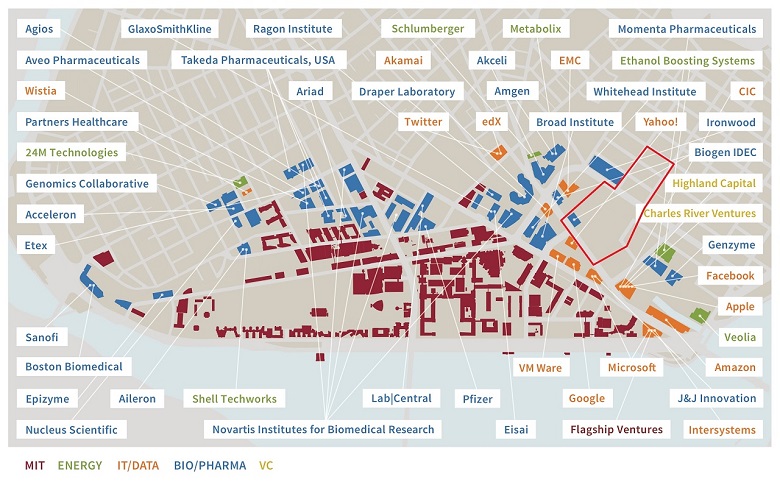 Figure 9: Illustration of types of industries and companies near MIT. My site is delineated by the red polygon. A new Biogen Idec building as well as a Broad Institute building have been built directly on my site since. Illustration taken from Kendall Square Association. Kendallsq.org.
 My site has come a long way from its marshland roots to its current attractive position for biotechnology companies. The construction and eventual truncation of Broad Canal has played an important role in shaping the industrial nature of my site. MIT’s relocation to Cambridge has also made land in Cambridge more attractive to certain industries, as illustrated in Figure 9. Kendall Square and its vicinity are poised to be a biotechnological hub, given the nature of clusters to attract more of their kind. There is still space to develop, particularly on my site, where large lots of land still belong to the government from the NASA days. However, as space is limited and companies are limited by zoning plans, the prices of land in Kendall Square will most likely only continue to increase in the near future.
Bibliography:• Public Documents of Massachusetts: Being the Annual Reports of ..., Volume 12, State Printers, Massachusetts, 1896.
• Jackson, Kenneth T. (1985). Crabgrass Frontier: The Suburbanization of the United States. New York: Oxford University Press. ISBN 0-19-504983-7.
• Sanborn-Perris Map Co. Insurance maps of Cambridge, Mass. New York : Sanborn-Perris Map Company, c1900-1970 v.1-2 [v. 2 lacks sheet 67.]
• Sanborn-Perris Map Co. Insurance maps of Cambridge, Mass. New York : Sanborn-Perris Map Company, c1996. v.1-2
• G.W. Bromley & Co. Atlas of the city of Cambridge, Massachusetts. Philadelphia : G.W. Bromley and Co., [1894-1930].
• Meeting Minutes, Craigie Dam Bridge, Massachusetts Department of Transportation, accessed on www.mass.gov/massdot/charlesriverbridges.
• Massachusetts Committee on Charles River Dam, Henry Smith Pritchett, chairman, Evidence and Arguments Before the Committee on Charles River Dam, Wright & Potter Printing Co., State Printers, 1903. Pages 459-461.
• Paige, Lucius Robinson. History of Cambridge, Massachusetts. 1630-1877. Boston: B.O. Houghton and Company. p. 183-185.