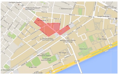
 Site Overview – This figure shows the location of my site in the greater MIT- Cambridge area. Image from Google Maps, February 2015.
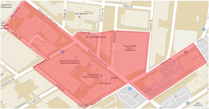 Site- This figure shows a more detailed view of the site under study. Image from Google Maps, February 2015.
 Any city, in its most basic form, is a large collection of flat-faced, non permeable, static, solid blocks set on a malleable surface through which dynamic liquids and gasses flow. This juxtaposition of fixed objects in a dynamic environment result in conflicts, but also leaves room for innovative design. In some cases, individual buildings or even whole cities are built to accommodate the flow of natural processes, but in many cases they are built in conflict with them. These conflicts directly affect the ways cities age and develop, and in turn they alter the way human beings interact with the built environment.
My site, located around Massachusetts Ave, just north of the railroad tracks, is a transition zone located at the intersection of MIT and the surrounding area. This transition from a campus to a consumer world is not abrupt, rather is spans the spectrum of labs to residential pockets, industrial areas to consumer stores. This transition zone is not at some ambiguous location; rather it has ties back to an old borderline that resulted from natural features in the area. Throughout weeks of observation of my site I was left with one central question in my mind, one idea that kept coming back, one theme I could not keep from noticing. This theme is flow. Whether it is the flow of air, heat, water, or even people, the greatest interaction the built environment has with natural processes is the ways in which it alters their flow.
In this paper I will unearth the environmental history of my site and shed light on how this history affects why my site is built in the location it is. I will explore the way nature interacts with my site now and how it is continuing to shape it and affect how we as human beings interact with it. Specifically, I will explore the flow of several natural processes through my site and examine how these flows in turn alter human flow. Lastly I will connect the site-specific observation and analysis I introduce and liken them to similar processes in the city as a whole. I propose that many of the small specific phenomena I will bring up stand for a larger issue of how cities and nature can coexist.
One of the initially most surprising attributes about my site is that prior to 1630, it did not exist, and was part of the bed of the Charles River. In fact, much of the Cambridge area, including my site, was created as filled land between the 1600s and 1800’s, and a great deal of my site was not filled until the 1880s (Fig.1). Since it is filled land, this area of Cambridge is very flat and has little to no elevation change. My site is located in the position of the small inlet near the location of Main Street that is visible in the map in Fig.2. Also visible on this map, is the rail line that cuts along the shore of the Charles. Note how is cuts directly across the inlet that is in the location of my site. This rail line is the same rail line that exists today and forms the southern border of my site: the border of MIT and Cambridge. This rail line was built around the natural shoreline of the Charles because it facilitated transportation of goods from shipping ports to inland areas. When the area was filled in the 1880’s the rail line remained in its position and became the border of the old city of Cambridge and the newer campus of MIT.
 Fig 1: Map of filled land after 1630 - Image from Alex Kreiger's Mapping Boston (see bibliography for full citation)
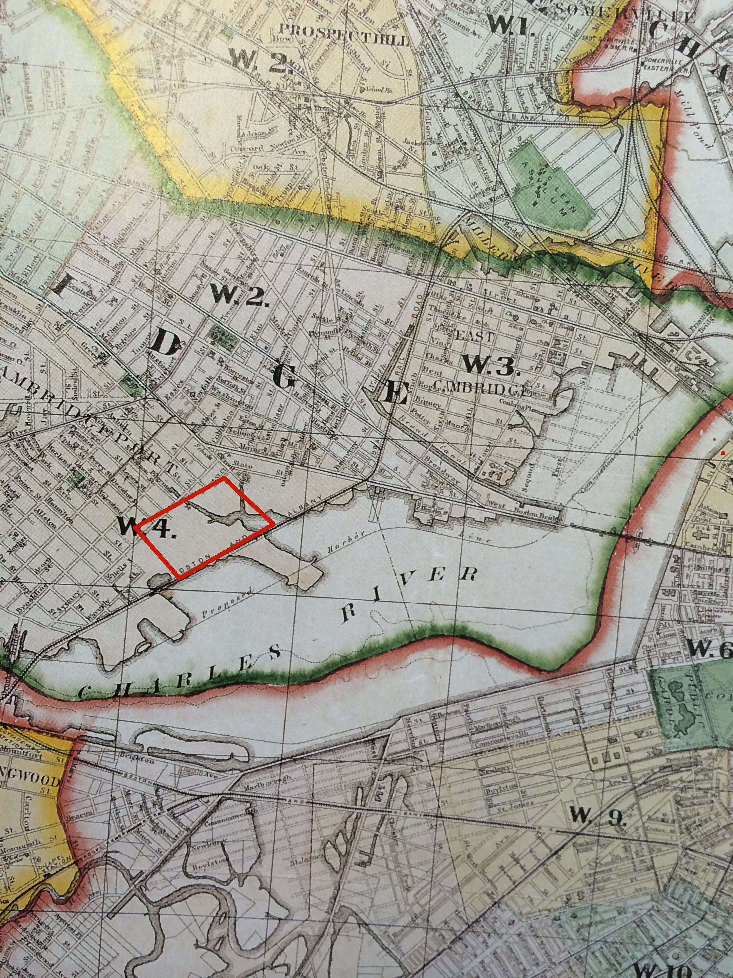 Fig 2: District map of Cambridge 1874 - Image from Alex Kreiger's mapping Boston (see bibliography for full citation)
If the crust of the Earth were a static and hard surface on which to build, cities would be unrecognizably different to how they exist today. The earth is in constant flux. Not only does it shift on a large scale, but on a smaller scale it is prone to constant or random settling, swelling, or sinking. The earth’s tendency to sink is particularly influential on my site, considering it is built largely on filled land. As Anne Spirn writes in her book The Granite Garden, cities like Boston (including Cambridge) that are largely built on filled land are especially prone to settling and sinking. The level of this settling depends on how the land was filled, what the composition of the material used as fill is, and how long it has been since the area was filled (Spirn 100).
Although my site did not exhibit any large instances of settling, upon closer observation I discovered several telltale signs of non-compact soil. As James Elkins writes in How to Use your Eyes, pavement can tell us a great deal about human traffic, as well as activity underground. I noticed that in many locations, it appeared that the manhole covers had sunk below the surface of the roadway, and that the asphalt was cracking around their rims (Fig.3). At first this seemed counterintuitive to me. I thought that since the pipe system was rigid in comparison with the roadway, the roadway would sink and the sewer system would protrude. After thinking about this phenomenon I realized that it actually made sense in my case and developed a hypothesis. My site is largely built on fill, which can be compressed. Since the roadway has a huge surface area in comparison with the pipelines and sewers, it almost floats on top of the soil, while the denser and more concentrated masses of pipes start to sink into the porous soil. Not only did this happen with sewers and manholes, but also with some stone curbs (Fig.4).
 Fig. 3: Sinking manhole - Image by author
  Fig. 4: Cracked and sunken curb - Image by author
 Human activities exacerbate the problem of settling soils under cities. My site is home to the construction site of the new Novartis headquarters, and sees a constant stream of construction vehicles, heavy equipment and construction workers every day. On Windsor St., which has become an access route to the construction site, the asphalt is cracked in two places longitudinally down the street. The distance between the cracks is the same size as the wheelbase of a construction vehicle and the region between the cracks is depressed about two inches (Fig.5). Again this demonstrates that when concentrated loads are applied to the soft soil it gives and in turn, the rigid structure on top of it cracks. These instances of settling may not be particularly threatening to the city in comparison to earthquakes and other such disasters, however they can compound and add up to expensive structural and infrastructural damage. Spirn writes that every building, street, or other human construct in a city should be “designed to prevent/mitigate hazards and to conserve and restore resources” (Spirn 125). In designing a city or in a smaller community it is necessary to take into account its geological situation. Maybe non-rigid building materials should be used for roadways if the ground beneath is prone to settling. Maybe the very fact that a site is on less dense soil can be advantageous in designing green spaces where large tree root systems help to solidify the soil. A fluid base does not have to result in a failing rigid structure if the structure is designed to accommodate for it in the first place.
 Fig 5: Cracked and sunken road due to construction equipment - Image by author
 Designing buildings and cities to accommodate for natural processes is vital for longevity of design. One of the simplest and most affective efforts towards this goal can be made by designing to accommodate for storm water. My site has very little exposed porous soil. Viewed from above, it is comprised of almost entirely asphalt roads, concrete sidewalks and tar roofs. There is a massive amount of water that collects on the roofs every time it rains, and since some roofs are almost ten stories tall, this water is under considerable pressure by the time it is brought to the ground. I noticed that the most common method of accomplishing this on large commercial or industrial buildings on my site is through gutter downspouts that are built into the walls of the buildings that elbow out at the bottom of the wall and spew out water. I observed one such downspout that had a stainless steel rectangular bollard about one foot in front of it set into the sidewalk (Fig.6). I was puzzled by this at first, but soon realized that it was placed there as an afterthought once the planners realized that all the water that flowed through the downspout shot out with such velocity that it would spray clear across the sidewalk and drench any pedestrians. This to me is symbolic of the constant struggle between the fluid qualities of nature and the impermeable immobile qualities of cities. It stands as a metaphor for how when we try to curb nature, we create additional problems further down the line that need to be fixed. If a city or building is not built in consideration of natural processes such as storm water accumulation, measures have to be taken as afterthoughts to deal with the consequences.
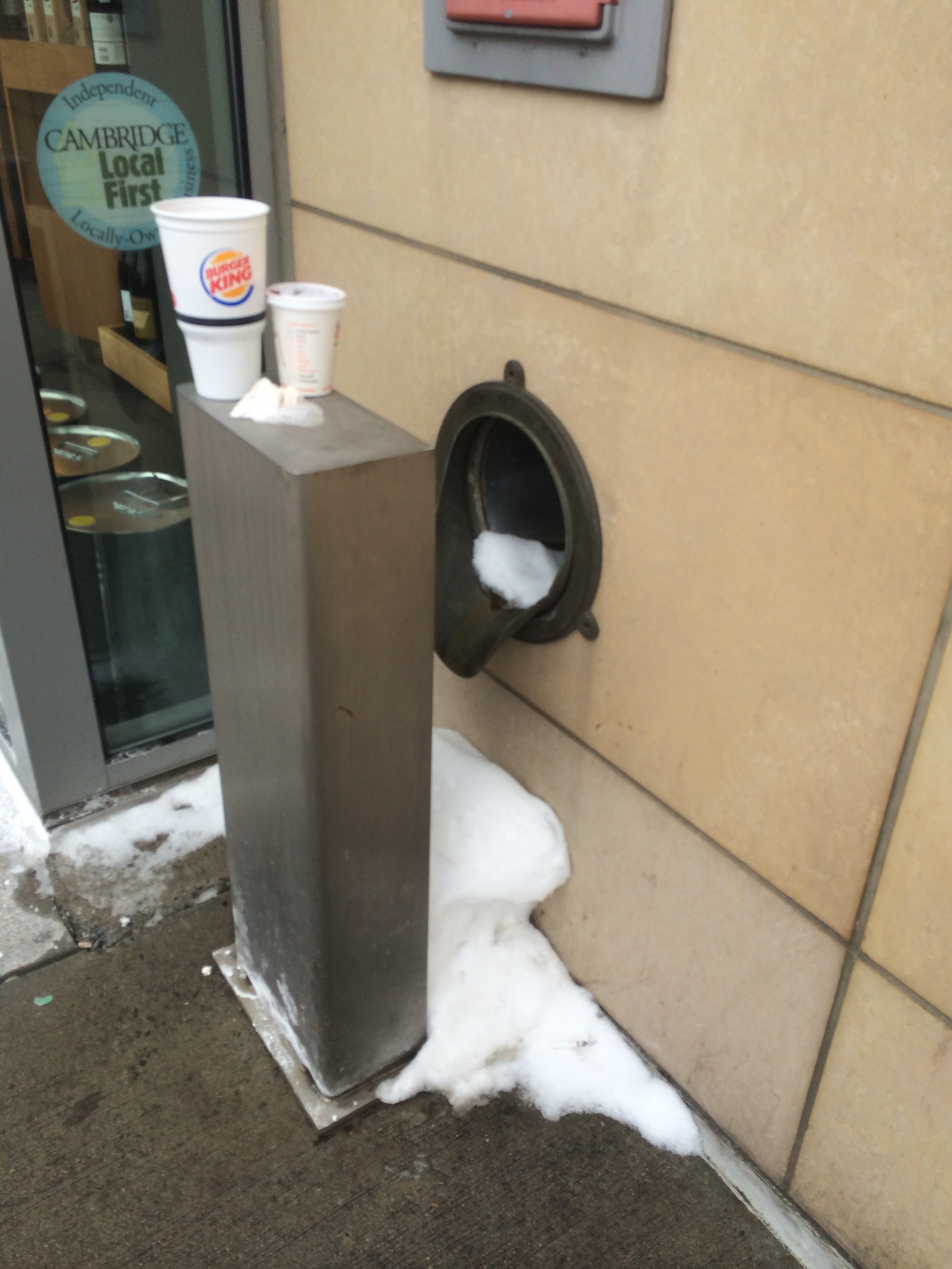 Fig 6: Gutter downspout on Novartis Building with spray blocking bollard - Image by author
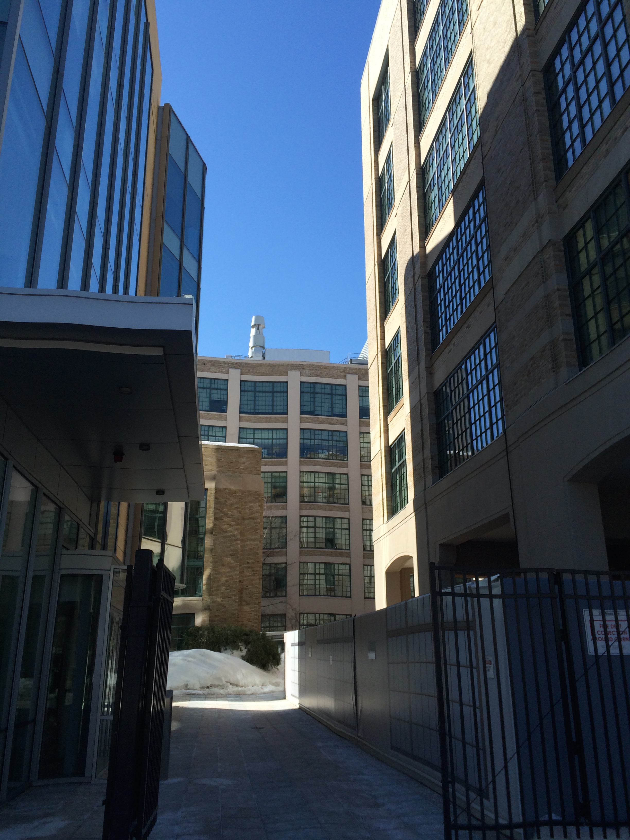 Fig 7: Novartis building courtyard - Image by author
 How do we accommodate for the flow of water through a city? Spirn addresses this in her chapter on water, saying that instead of diverting storm water, it can be stored. Rooftops, parking lots, and parks can be designed to store rainwater and gradually allow it to percolate into the ground without adding an additional volume of water to the natural storage capacity of the ground in surrounding areas (Spirn 145). The aforementioned downspout with the bollard is on the Novartis Institutes for Biomedical Research building on Massachusetts Ave. This building actually has a central courtyard that, although it only has a few trees arranged in a minimalist fashion, can be considered a green space (Fig.7). I see this courtyard as a potential solution to the large amount of rainwater that accumulates on the building’s roof. The courtyard could be turned into a system for storing storm water in an aesthetic manner by incorporating slow-draining paving systems, more absorbent plants, water features, and creating a rain-fed irrigation system for the plants. Fresh water distribution and storm water management pose a significant challenge to large cities, but through innovative, environmentally conscious design, buildings and cities can use storm water management as an effective way to steer towards sustainability.
Although the flow of water seemed to be the most obvious display of the force of nature on my site, the one that had the largest effect on the sensory experience was wind. Wind also accounts for the largest natural variation from place to place on my site. There are a few distinct areas of interest where the effects of the flow of air were profound. The first of these is on Cross St., which is surrounded by a row of tall buildings on each side. As soon as I turned left onto Cross St. from Landsdowne St. for the first time, I felt a considerable difference in wind speed. In fact, at one point it was so harsh, that it was quite uncomfortable. As I continued to walk down Cross St. I came to the end where it meets Albany St. At that corner there is a parking garage, and, as the parking garage diffused the wind, it became pleasant again. The corner of Cross St. and Landsdowne St. contains a sharp corner of the Novartis building, subtending an angle of about seventy degrees. At this point the wind was particularly strong (Fig.8). Directly across the street, however, the wind was almost nonexistent. Upon looking up I noticed that on the face of the building was fastened a complex system of ductwork that acted as a wind baffle and diffused the downdraft that would result from a building of that height (Fig 9). This phenomenon that I had experienced Spirn describes aptly in The Granite Garden when she writes, “The complex pattern of winds around an isolated building creates conditions where a person may sit in comfort in one spot and be knocked over by the force of the wind in a spot only twenty feet away”(Spirn 66). Indeed, at the corner of the Novartis building, standing was considerably unpleasant, however thirty feet across the street, I could barely feel any wind.
 Fig 9: Ductwork along wall, reduceding wind speeds at base - Image by author
 On the opposite side of my site, there is another interesting interaction between wind flow and the built environment. The train tracks on the southern border of my site thread through the power generation plant under a boxy underpass. While walking towards this underpass the wind speeds seem normal, but as soon as I got under it, the speed of the wind increased at least four-fold (Fig.10). This is a classic example of a tunnel effect. Since the tracks run east-west, the tunnel effect is amplified due to the prevailing west winds.
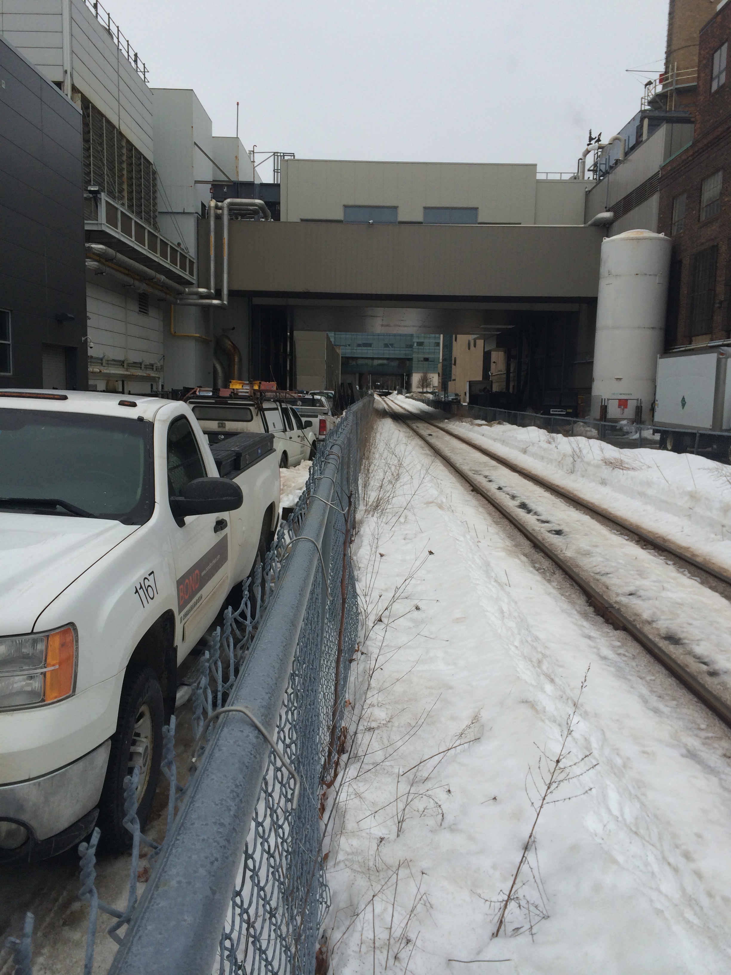 Fig 10: Railroad tracks threading through powerplant under overpass- Image by author
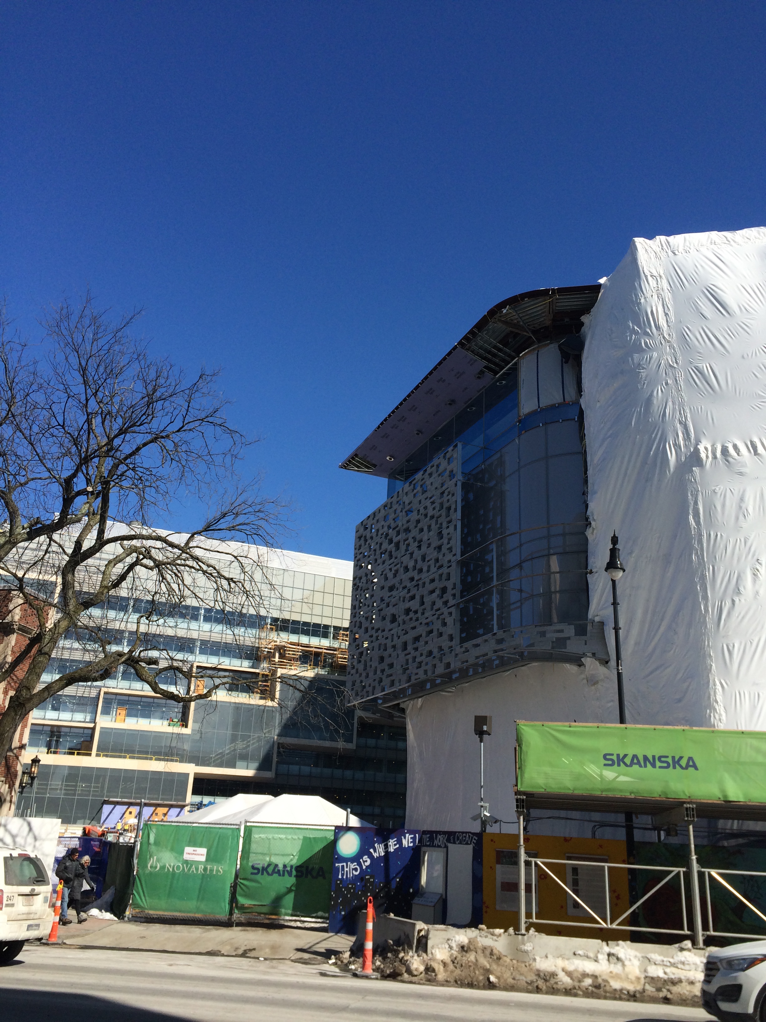 Fig 11: Semi-permeable stone facade on new Novartis headquarters, reduces wind speed - Image by author
 Wind can be a serious issue for city planners because of the drastic effect it can have on the comfort level of people moving through the city. I experienced the discomfort of walking around corner facing a blisteringly cold wind first hand. However, I also experienced something that could prove to be a solution to some of the problems winds cause. When I stood next to the building that had the exterior ductwork, I did not experience excessive winds. If architects can design buildings with facades that help diffuse the winds, then the down draft of large towers will be less of a problem. This can be accomplished through green walls, which have additional environmental benefits, or with semi-permeable facades as utilized in the construction of the new Novartis Headquarters on my site (Fig.11).
It is easy to understand that people would rather walk on a calm street than a street with raging winds, but wind speeds and physical comfort are not the only natural factors that influence how human beings interact and flow through a city. Cities are built in natural environments and therefore interact with nature, sometimes in harmony, and sometimes in discord. Tracing back to my site’s environmental history can help draw a full circle about how nature influences construction, which then gets influenced by natural processes, which in turn affect how human beings interact with the built environment. The oldest backbone of my site is the rail line that traces its southern border. This rail line was originally built to follow the natural coastline of Cambridge to facilitate easy access to shipping ports. As a result, industrial buildings were built around the tracks. These buildings became very dense and restricted wind flow so much that it became uncomfortable to walk along some of them. Consequently, people avoid them and keep to the wider streets like Massachusetts Ave. Since the railroad tracks cannot be traversed by every street, only certain streets like Massachusetts Ave. cut across them and thereby concentrated channels where people funnel through. This funneling of people is a result of the built environment that was constructed the way it was due to the natural geography of the area centuries ago.
Every city starts out the same way: an area of land, one with nature. Throughout the course of its existence its relationship with nature fluctuates from adverse to harmonious, and eventually every city will die and once again become one with nature. What many architects and planners fail to realize is that through its life, cities are always part of nature, and must be built accordingly. They are rained upon just as much as a porous fields, they are windswept just as much as bald mountaintops, and they are shone upon just as much as deserts. In retrospect, when thought of as such organic objects, it seems only natural to design cities in such a way that they can adapt to these natural processes readily, and not be destroyed by them. However, human nature often shadows the clarity of hind-site and makes us try to assert our power by building things bigger, taller, stronger, faster than ever before. We throw down our gauntlet when faced with nature and challenge her to destroy what we have made. It may appear like we have been victorious when our landscapes of paved lots and stiff concrete walls cover the horizon, but in a few months, years, even decades, nature reasserts her presence by filling these paved lots with potholes, and these concrete walls with cracks. We are living at during a time of transition however, in the past decade designers are beginning to realize how pivotal it is to design for sustainability and in the next decades I believe that this trend shall continue. Not only will this make cities more resilient, it will also make them more beautiful and enjoyable places to live with cooler temperatures, more shade, green spaces, and softer materials. Urban form will shift from following the ebb and flow of the struggle between nature and the built environment, and shall become more like an intertidal zone where the two mix and innovation is born.
Spirn, A. The Granite Garden. Basic Books: New York, NY. 1984.
Kreiger, Alex. Mapping Boston. MIT Press: Cambridge MA.
- Fig. 1: Original Kreiger map
- Fig. 2: From Griffith M. Hopkins and Co. Map of the City of Boston, and its Environs. Philadelphia, 1874. Engraving. 125 x 146 cm.
Clay, Grady. Close-Up: How to Read the American City. The University Of Chicago Press: Chicago, IL. 1980: pp. 11-12, 38-65.
James Elkins, How to Use Your Eyes (Routledge, 2000): "Preface," "How to Look at a Culvert," "How to Look at Pavement," "How to Look at a Twig."