 Industry looms over a neighborhood game of flag football
The traces of the past that are present on my site are remnants of a neighborhood and an environment that have now completely disappeared. Although we can only see the artifacts and clues to this past, their creation has shaped how the neighborhood and the different parts of the plot exist today. The historical maps and the natural processes that explain this site offer an idea of how this seven block section of Cambridge came to exist, but they also provide an important framework with which we can gain perspective of the trends that will continue to shape this site in the future. By unpacking these traces and clues in a broad way, we will see that because this plot developed at different times it has adopted different personalities that are in tension with one another. Ultimately this will provide evidence of an impending clash between the strong community oriented northern part of the plot and the powerful industrial foothold in the southern part of the plot, a clash that can represent a broader societal trend that has been a partial result of growing technological institutions such as MIT. On the eve the institute’s 100th anniversary of moving to Cambridge, and the eve of a new technological age, the contrasting characters of the two parts of this plot come to represent a small fraction of an influential trend that is expanding in cities across the world.
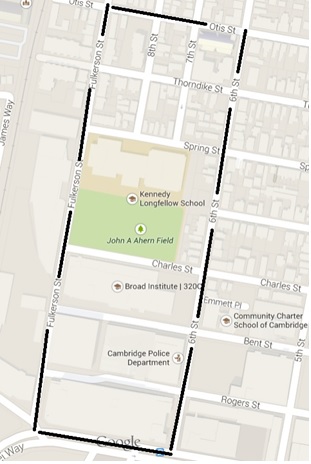 This shows a Google Maps view of the site with the boundaries indicated by the black lines
As discussed previously in a study of historical forces, the southern part of my plot differs from the northern half mainly due to the lag in development that occurred around the turn of the 20th century while other parts of Cambridge were developing more rapidly. This lag provided time for a growing industry to move into the plot which preserved its original layout with broad streets and large plots of land. The conservation of this street pattern is an artifact of both the original design and of the social forces that entered and utilized this original design with expansive industrial buildings. Figures 1 and 2 below illustrate this preservation of street pattern in the southern part of the plot that resulted from a pause in its development.
 Figure 1 shows a zoomed in version of the Google Maps view to show the street pattern of the southern part of the plot
.jpg) Figure 2 shows a zoomed in version of a figure from the previous paper to show the near exact street pattern even in 1873 with the exception of the changes to Potter and Binney Streets.
Figure 2 shows a zoomed in version of a figure from the previous paper to show the near exact street pattern even in 1873 with the exception of the changes to Potter and Binney Streets.
The following periods of fast and relentless development of these three blocks around 1950 have erased any artifacts of the previous buildings. Figure 3 is reproduced below from the previous paper to show the relative lack of development in this part of the plot in the late 20th century compared to how much it has changed today in an incredibly short span of time.
This lack of artifact from the pre 1988 period is not a complete lack of trace of these buildings. In a broad sense these buildings are traced with the fact that they boxed out residences from entering the blocks, even though the buildings in most cases did not take up all of the space of the blocks. The land was on some level tarnished however by the industrial presence which kept any housing out of the area. This led to the turn of the 21st century which brought the large brick buildings used for scientific and industrial research that we see today into the aligned and open blocks of the southern part of the plot. In The Power of Place Dolores Hayden addresses this reality in industrial areas, noting that “As the productive landscape is more densely inhabited, the economic and social forces are more complex, change is rapid, layers proliferate, and often abrupt spatial discontinuities result that cultural landscape studies seem unable to address adequately” (Hayden 17). This quote captures the tight industrial layout that seems to have suffocated any residential areas that could have had seedlings in my site in the early 1900’s. In many ways the reality that these blocks are dominated by factories in an otherwise residential neighborhood is a firm trace of the history that maps have revealed for the area, giving insight into the potential that industries have to take over land and devalue it to homeowners and neighborhoods. We will see some differences and similarities in how the traces and artifacts of the northern part of the site are expressed and what they reveal about the vastly different character of this neighborhood.
The northern part of my plot is starkly different from the southern part, and the presence of certain traces and physical artifacts of the past contributes to a distinct community that has formed there. This part of the plot was rapidly developed as residential during the mid-1800s, and the layout of the street has only undergone some minor changes since that time. Figures 4 and 5 below are photos taken between John Ahern Field and the Kennedy School, facing west.
.jpg) Figure 3 shows the complete lack of development in the southern half of the plot, again reproduced from the previous paper
Figure 3 shows the complete lack of development in the southern half of the plot, again reproduced from the previous paper
 Figure 4 shows a view from where Spring street was chopped off in order to connect the elementary school with the adjacent park
 Figure 5 gives another view from further away of what is seen in figure 4
Shown is the original path of Spring Street, which followed the pattern of the previous grid but was cut off in order to connect the two smaller plots in order to create one large one. This space, now used for parking and a community garden (figure 6), is a trace of the previous street path that was changed in order to accommodate a school building that would connect to a field behind it.
 Figure 6 is a photo taken in the same spot as the one in figure 5, but instead showing the community garden that was planted by students in the site of what was previously a road
The persistent land use of this area and the importance that an open field had for the community had some role in the trimming of Spring Street and that fact that it remains a public field even today. Moving one block to the north of this school we begin to see the residential neighborhood take shape, and figures 7 and 8a give a general view of what is found here.
 Figure 7 shows what is typically found in between houses on the plot if there is enough space. The houses are close together and the space is often not used for parking but instead for communal areas with grills, tables, firepits, etc.
 Figure 8a shows another example of this with houses placed in asymmetric patterns that leads to a lack of street access for many homes but an increased sense of community with close proximitiy and the sharing of yard space
The setup of these houses represents a trace of the construction of the neighborhood prior to the present day. The spacing between the houses is small as will be demonstrated with other figures. In addition, the house towards the back of figure 7 does not have any street access, along with many of the central houses in the northern section. Looking back to the old maps such as figure 8b, we see this setup of houses at the center of many of the blocks due to the reduced need for street access before the broad use of the personal automobile in the city.
These houses are a trace of what was once there, and begins to prepare this part of the plot for a strong inheritance and expression of its past, contrary to the southern part of the plot. Figures 9 and 10 show more examples of the incredibly close spacing of houses that is a trace of the setup from historical periods where driveways were mostly unnecessary in a city suburb, and where lower income workers in nearby factories were housed.
These traces of the past also meld together with the layers that are visible in the site, and it is here that we begin to see the source of the community and togetherness of this neighborhood.
The Sacred Heart Church is one of the major focal points of my site, and even within it we see the layers of the past and present coming together in a culturally important way for this community. Expanding to take up an entire block over the turn of the 20th century, this church has thrived and grown in this residential location. Shown below are figures 11 and 12 which are photos of two stain glass windows from the inside of this church in the same hallway.
These photos combine traces of the past along with the new layers that create what we see today standing inside of the church, which is characteristic of this northern part of the plot. The church grows and adds new windows like any building would, but what makes this different from the industrial buildings of the southern part of the plot is the fact that the antique artifact of the old window remains and hasn’t been removed or destroyed to make space for a new window, and there is no clash between them. We see more examples of this looking at figure 13 which shows two side by side houses on Fulkerson Street.
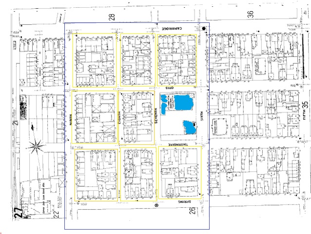 Figure 8b displays the situation in the northern part of the plot that had houses locked at the center of other houses with no street access, a remnant of the history of this plot which was used to house low income factory workers. Today, although it does not house factory workers, the layout has been preserved and fosters a community and proximity between the houses
 Figure 9 shows an example of two houses on the plot that have almost no space between them, which is relatively frequent throughout
 Figure 10 is a close up shot of the small house spacing, a trace of the original way that houses were constructed in a period of rapid development. Trash and leaves tend to buildup in these spaces and is difficult to remove
 Figure 11 is taken inside Sacred Heart Church in the main hallway looking north, showing one of the antique stained glass windows.
 Figure 12 is taken in the same spot facing south, showing a more modern stained glass window, representing an additional layer just within this church hallway on the site
 Figure 13 is taken of two houses on Fulkerson Street showing the differences in the three layers of houses including the effort taken to keep the house on the right looking antique.
In this photo we see three different layers of the past between the three buildings. The older house on the right has been restored and taken care of, but is most certainly a trace of the older house and its style that stood there previously. To the left is a more modernly designed house, but one that appears to holds the same number of residents as the one adjacent to it. In the background is a long apartment building that does not appear on the maps dating even to 1988. Although these three buildings came along at different times, they coexist in a layered neighborhood where the antique qualities of the past are preserved even while the necessities of the modern day have been moving in. The neighborhood environment lends itself to layering these buildings together. Below in figure 14 is another example of these layers coming together, as a yard at the corner of Thorndike and 6th street is shown.
 Figure 14 shows three stone pillars that at one point made up some of the foundation of a building. They have been (mysteriously) left in the yard for some reason, and are a trace of the pre-existing building that once stood here
In this photo we see three of a set of eight stone pillars that at some point held up metal rungs forming a fence around the property. They have been left in the yard and serve as an artifact of the property’s fence that was once there. Historical maps indicate that this property was residential at all points in time, and that along the way someone decided to keep the previous owners fence posts for remembrance or beauty. A representative of the Sacred Heart Church spoke with me about the church’s history and impact on the area as this house was directly next to it. She mentioned that the church has been so successful over the years because it was situated at the center of relatively low cost housing that provided places for workers to live, and they then were able to have a religious tie to the neighborhood as well. Figure 14 shows the front yard of the same house shown in figure 15, and figure 16 shows a placard that is found across the street.
 Figure 15 shows a small religious statue wedged between two bushes at the center of what was the old building marked by the pillars in figure 14.
 Figure 16 shows a small war memorial near the entrance to a brick building that has been purposed as a religious building on Thorndike Street
This small statuette represents an artifact of the heavy influence that the nearby church has on this neighborhood. The past has fused with the present in these ways and formed a neighborhood that is tightly wound (both physically as in figure 9 and metaphorically here). The placard also gives an idea of the importance of history in this area, and more specifically in honoring those who came before us and risked something that made this community better, unlike the southern plot where no such plaques are found. Figure 17 shows how one resident in this area has converted a one car garage into a local business.
 Figure 17 shows a car garage that has been repurposed as a small daycare center run by one women who I spoke with. She told me that her clients are nearly all from withing a few blocks of her house and that she knows most of them on a personal basis.
I spoke with the owner of this converted children’s daycare who said that the majority of her clients live within the boundaries of my site or slightly beyond. The use of the small amount of land in this site does give an indication of what this community values. We do not see the broad streets and open, unused space that is found in the southern part and instead we find a neighborhood that is built on a landscape that is a trace of the past and that also layers the existence of the past within it. An emphatic example of this is found below in figure 18 which shows the area surrounding a tall apartment complex on 7th street.
 Figure 18 is the site of the horse livery that dissapeared in the mid 1900s making way for an apartment building that uses the land as an outdoor place to sit or walk around for the public use
This photo in the mid 1900’s would have shown a large horse livery stable which was taken over by this apartment building by 1970. While adding a more modern layer to this block with the building itself, the complex has preserved a trace of the past land by converting the exact bounds of the livery stable into a small outdoor sitting and picnic area for the public. At the cost of land in this area, it is unlikely that in the southern part of the plot where there are few connections between land plots via owners or users that this valuable land would have been used as a sitting area as opposed to a space for another building. The layers on the northern part of the plot enhance the traces of the past in a way that fosters a sense of community and care for this area by the people who live there, contrary to the southern part of the plot which feels cold and empty in comparison.
The traces, artifacts, and layers that are found throughout my entire site differ in ways that emphasize how they came to be and where the overall site is heading. It is inevitable that cities will face great changes over time, and my site provides a fascinating example of how this change is handled differently by areas with different traits. In the southern part of the plot we see virtually no traces or artifacts of the past aside from the street pattern itself which only changed slightly. In the northern part however we find a great deal of integration and preservation of these parts of the past, and they mix together in a way that seems distinctive to the neighborhood setting. The layers of time in the Sacred Heart Church were previously discussed, and figure 19 provides a view of another layer that involves this church.
 Figure 19 is taken from Fulkerson Street. Near the left is the top of the Sacred Heart Church, and a little bit to the right is a smokestack from a nearby factory that at one point produced certain types of candy.
This skyline as viewed from Fulkerson Street shows the third layer that is found containing the central figure of the church. This photo hints at how the past and the present are being brought together and used in this community space, and the result is a community that is discernibly close with members that know each other and interact on a personal level. Figures 20 and 21 contribute to this sense, showing the area in and around John Ahern Field joining the northern and southern parts of the plot.
Figure 20 shows the John Ahern Field being used on a Saturday by men and women in the community. One of the people there said that most people consider it a meeting place for outdoor activities including sports and recreation. Weekdays it is used by the elementary school. The contrast with the industrial part of the site behind is apparent.
 Figure 21 shows a sign on the fence of a street hockey rink where people were participating in a game. Some of the players had not heard of Jimmy Johnson, and others said that he was a local player who loved the game. The court is named in his honor and is another place where the community comes together. There were more than twice the number of people in the game as there were watching.
These areas are heavily used community spaces that are traces of the pause in development that allowed for their protection from industry over one hundred years ago. On a given Saturday in the site people of all ages and ethnicities are found in these areas talking, and people are out in the neighborhood interacting and spending time with one another. In the southern part of the plot on the same day the streets are empty, the buildings abandoned for the weekend. Hayden notes that “people make attachments to places that are critical to their well-being”, and describes how “humans come to know places through engaging all five senses, sight as well as sound, smell, taste, and touch” (Hayden 16). The northern part of the plot is made into more of a place for living by this association that it has with peace and more natural feelings, and it shapes the feel of the city environment even with a dense population. The effect that this has on the plot is immense, and it is attributed at least in part to the way in which history and the past have affected the site. In some ways it seems that neighborhoods create a more suitable environment for the preservation of the past and its integration into new layers of the city, but one of the major questions raised by the diversity of my site is whether or not it would be possible to expand this ability to the industrial space.
Looking at the overall trends within my site, it is clear that the way in which land is used has an effect on what happens to it. The land uses that move most rapidly into these areas and that have the foothold that they need to stay there have dominated throughout the history of this site. This entrenchment raises critical questions for the future of this site. While the southern part of the plot builds up its infrastructure and use of its land, the northern part continues to generate a strong community setting where the past is layered into the future as time goes on. It is unlikely that any sweeping change will occur throughout the site in the near future, but the slow trend towards industrial development will exert a stress on the community, beginning with the place where the two sectors meet: John Ahern Field. This community sanctuary, along with its adjacent school, will be tested by the forces that create change in cities, and as this continues there will be a persistent tension in this area. The situation does not have any obvious resolution, though the question will be raised: Can industrial areas adapt to protect areas that are cherished and valued as places of living? The choice between adaptation and refusal towards change will either define the generation of the new city and its layered history, or the elimination of this idea.
Works Cited:
Figures 3-21 in this text were taken by and belong to the author.
Figure 1: "Google Maps." Google Maps. Google, 2015. Web. 07 Mar. 2015.
Figures 2 and 3: "Sequence 20: Hopkins, Griffith Morgan." Atlas of the City of Cambridge. Harvard University Library, n.d. Web. 10 Apr. 2015.
Hayden, Dolores. The Power of Place: Urban Landscapes as Public History. Cambridge, MA: MIT, 1995. Print.