ArcView GIS
Background
Parts
-
Menu Bar
Button Bar
Tool Bar
Document Window
Document Types
-
Projects - a basket of pointers to parts
Views - Legend, Table of Contents, Themes, Shapefiles, Images, CAD, Arc/Info coverages
Tables
Charts
Layouts
Scripts
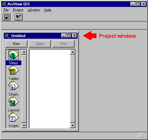
Projects
Project Window Project menus, buttons Extensions Open a Sample Project |
|
-
Open a View
Themes - points, lines, polygons, images
Table of contents - checkbox, active themes
Zoom In Tool
Zoom Out Tool
Zoom In Button

Zoom Out Button

Pan Tool

Other Zoom buttons


Theme Properties

Legends - the Legend Editor and Symbol Editor
Add Themes

View Properties
Projections - Units, Coordinate Systems, Projections, Spheroids
-
UTM
Latitude/Longitude (decimal degrees)
State Plane - South Pennsylvania
Measuring Tool
Selection
Help
Related Websites
-
Environmental Systems Research Institute(ESRI)
ESRI's What is GIS page
ESRI Virtual Campus
Environmental Systems Research Institute. ArcView GIS. ESRI(On Reserve)
Bruce Davis. GIS: A Visual Approach. OnWord Press.
Scott Hutchinson & Larry Daniel. Inside ArcView GIS 2nd Edition. OnWord Press.
ArcView Exercise Book. OnWord Press.
ASSIGNMENT
You may do this week's assignment in pairs. It should be turned in on paper.
- What is the east-west length in feet of the large grassy space north of Sulzberger Middle School (measure along Wyalusing Av from 48th to Creighton). The space is bounded by 48th Street, Wyalusing Avenue, Creighton Street, Girard Avenue, and Lancaster Ave.
- Using the Building Footprints layer and either the Measure tool or a Graphic Shape, what is the area in square feet of Sulzberger Middle School?
- Using the 'TOPO_1ft' theme and the Identify Tool, what is the elevation of the northeast street corner at 49th and Aspen? What is the elevation in feet of the southwest street corner at 48th and Brown?
- Make a printout of a View of the Mill Creek neighborhood at 1:4000 scale. The view should have at least the following layers: Topography, Building Footprints, Preurban Hydrology, Sewer and the aerial photograph.
last update: 7 Oct 1997