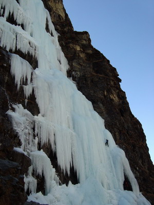
 Dave Custer leading 'Sultans of Swing' (Photo by Susan Ruff)
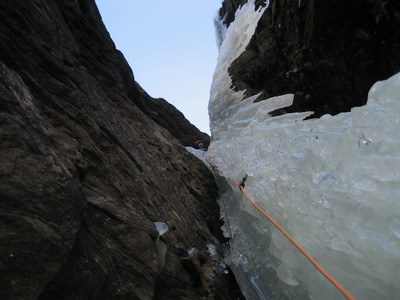 and looking down the 'X-chimney'.
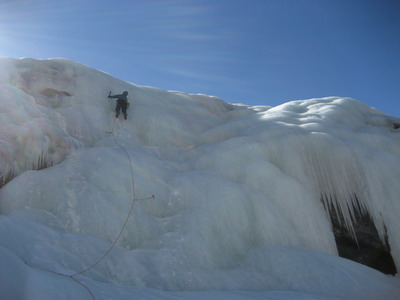 Susan Ruff on the White Tide. Photo by Dave Custer.
The Kusum Kunguru basecamp is located at ~4300m; to reach it from Monjo (2800m) whith packs will require a full day even for an acclimatized party.
The trail does not start at the bridge across the Kyashar Khola in Monjo and does not follow the river contrary to what is shown on the map. The best way to find the trail is the following: entering the village of Monjo from the south, follow the main trail to an upscale hotel complex on your right (called Everest Summit Lodges or something like that, a few hundred meters from the entrance to the village). Immediately after the hotel complex, turn right into a narrow stone path leading uphill. The path leads you to the edge of the village where the trail starts. The trail is fairly good until the makeshift bridge over a subsudiary of Kyashar Khola at about half-way (or perhaps a bit less) which offers a convenient sunny lunch spot.
After the bridge comes a somewhat precarious section of the trail that crosses a frozen water flow (can start ice climbing right there:) and a landslide. This section can be bypassed on easy slopes above the trail. Further on, the trail becomes quite faint and might be in places hard to follow, especially after a snowfall. Closer to the basecamp area it merges with a better trail used by yak herders (be warned, however, that that better trail wouldn't lead you back to the village). Finally you will come to a vast flat area of the basecamp. We set camp at the eastern edge of this area, near the terminal moraine of the Kyashar glacier.
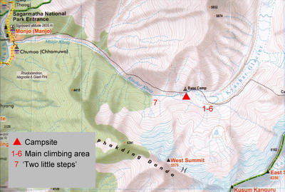
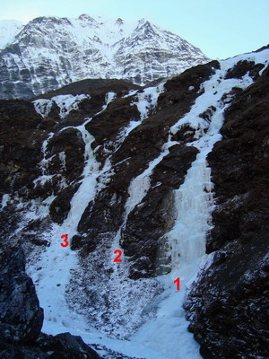
1. Vegetable Dreams, WI4, ~400m. Two pitches of good steep climbing are followed by low-angle ice separated by some WI3 steps. 8 pitches with a 50m rope.
2. Unclimbed
3. Moebius Strip, WI3, ~400m After a steep start, this flow splits in two branches; the left one, wending and winding its way in a long low-angle romp up the hillside, has been climbed.
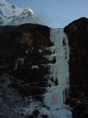
4. Sultans of Swing, WI5, 120m. One of the most beautiful frozen waterfalls in the world! Steep climbing throughout.
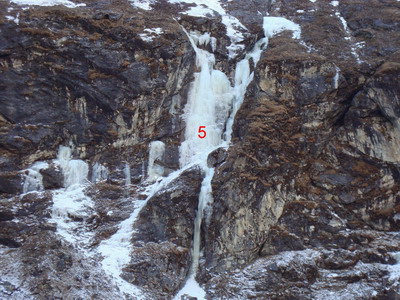
5. X, WI5 or 4+, ~120m. The X-shaped ice-flow can be climbed in 4 possible ways: the left start is WI2, the scary-looking 'X-chimney' on the right is WI5. Both upper branches are WI4+, with the left one being more sustained.
6. White Tide, WI3, 180m. The massive left-most flow, mostly low-angle, with a short, wide steeper section. If you need to acclimatize before tackling the harder routes, this flow is nicely situated: it provides low-key climbing, the approach takes you past the bases of the rest of the routes, and the top of the climb introduces you to the trickiest part of the descent for the rest of the routes (the descent trail crosses the eroded White Tide gulley just above the top of the flow).
Descent from all climbs can be done on foot. From the White Tide the descent is obvious. From all other climbs, continue up on grassy slopes (trending left to make the way shorter) until you intersect a faint yak trail. Follow the path East (climbers left). After passing over the left-most ice flow (the White Tide), follow moderate grassy slopes straight down.
 Dave Custer leading 'Sultans of Swing' (Photo by Susan Ruff)
|
 and looking down the 'X-chimney'.
|
 Susan Ruff on the White Tide. Photo by Dave Custer.
|
Some shorter climbs are found below the basecamp; you will see them from the approach trail on the opposite side of the valley. From the camp, descent keeping to the northern side of the valley and follow moraine ridges to reach the climbs (~30 min. from the camp). Only one route has been done here so far.
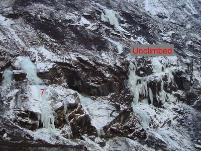
7. Two Little Steps, WI4, 80m. Steep climbing at the start, the second pitch is WI3. Descent on foot (obvious).
 back to the main page