Landing Site
Targeting Diacria
Selection Process
Step-by-Step Results
Top Six Sites
Previous Landings
Site Terminology
Sources
Landing Site
Lists of Sites Remaining after Each Step
The links below will jump your browser to the part of this page that corresponds to the given step.
Step OneStep Two
Step Three
Step Four
Step Five
Step Six
Note: The site numbers are from the NASA Center for Mars Exploration.
The qualitative exclusion of 94 sites was accomplished with this original, generalized rubric:
Any site that showed one or more of the following would be crossed off our list:
![]() -Surface at site is largely hardened lava, making anything fluvial difficult to get to.
-Surface at site is largely hardened lava, making anything fluvial difficult to get to.
![]() -Terrain is unusually rocky or relieved, making landing or exploration dangerous.
-Terrain is unusually rocky or relieved, making landing or exploration dangerous.
Any site worth investigating would show evidence of ancient hydrological activity.
Any site that showed hydrological activity AND showed one or more of the following would be kept on the list:
![]() -A surface albedo indicating that water-deposited sediments are present.
-A surface albedo indicating that water-deposited sediments are present.
![]() -Curved flow channels are present.
-Curved flow channels are present.
![]() -Ejecta from nearby craters are visible.
-Ejecta from nearby craters are visible.
![]() -Sediment layers are exposed in nearby cliffs or canyon walls.
-Sediment layers are exposed in nearby cliffs or canyon walls.
![]() -Flat terrain appears safe to land on.
-Flat terrain appears safe to land on.
![]() -Ancient rocks there date from the Hesperian or Noachian ages.
-Ancient rocks there date from the Hesperian or Noachian ages.
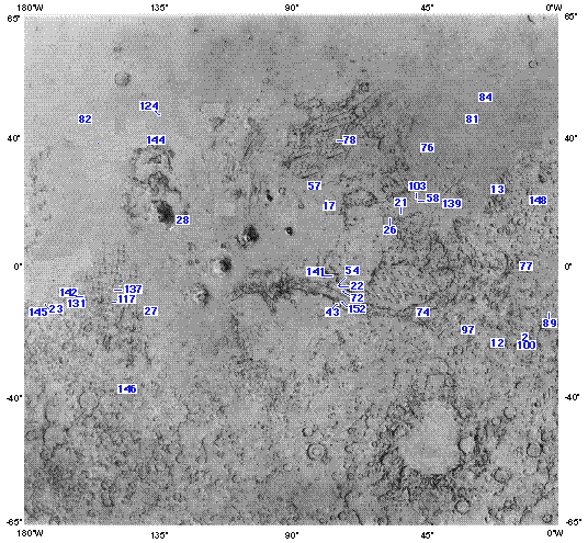
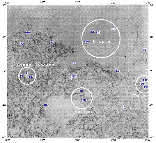
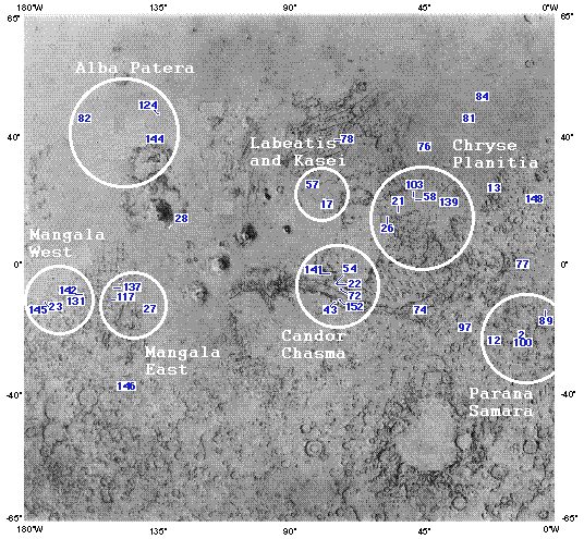
Mapping the remaining sites on the surface gave the following two pictures. Images courtesy of the Center for Mars Exploration Landing Site Catalog, modified to show only the sites remaining after Step One.

After circling sites that appeared to be close, we had 11 clusters of sites that offered good potential. This was before the rover range was shortened.
Steps Three and Four:
At this point, we made a large chart listing the characteristics that each site had. We worked using our cluster method, but when we had to abandon the cluster idea, our chart was still useful.
Step Five was to take our diversity chart and eliminate all sites that did not have four or more diversity checks. We kept Gusev because we knew how much information was available about that site. Although Gusev may not be as diverse as other sites, it began to look like a safe back-up at this point.
The "Pro-vs.-Con" charts that we used to order our thoughts about the six best sites appear below.
|
Gusev |
|
|
Pro |
Con |
|
A curved flood channel indicating rapid sedimentation - rapid sedimentation indicates possible fossilization |
Cliff wall and fluvial sediment may not be accessible simultaneously (it is uncertain whether or not an LMR can get to the top of the crater rim from the floor) |
|
1000km cliff wall for cliffhanger |
Large crater diameter - too extensive for rover range |
|
Crater ejecta present |
Apparent lack of geothermal activity |
|
Fluvial sediment inside crater |
Instability of ground ice due to low latitude |
|
Kasei |
|
|
Pro |
Con |
|
Safe landing |
Instability of ground ice due to low latitude |
|
Curved flood channel |
Less crater ejecta - reducing sampling possibilities |
| Likely presence of ground ice |
Cliff wall and fluvial sediment are not both accessible |
| Rover must be capable of climbing a 30% slope | |
|
Ares |
|
|
Pro |
Con |
|
Good cratering - increasing sampling possibilities |
Most flood channels are straight - indicating a short duration of fluvial-lacustrine environment |
|
Several curved flood channels |
Presence of sand dunes suggests a very windy site; may be difficult to land here |
| Crater bank is likely packed with fluvial sediment |
Instability of ground ice due to low latitude |
| Low likelihood of finding fossils | |
|
Diacria |
|
|
Pro |
Con |
|
High northern latitude, low elevation |
Flood channels are straight |
|
Potential for geothermal structures |
Potentially steep crater side might make it difficult to access the crater rim from the floor |
| Southern half of crater may contain rough terrain | |
|
Crater ejecta present in area |
|
|
Delta is extensive, indicating prolonged hydrologic activity |
|
|
Phaethontis |
|
|
Pro |
Con |
|
Heavily eroded crater indicates long-duration water activity |
High southern latitude |
| Some areas consist of very rough terrain | |
|
Smooth, safe landing site |
Very high elevation |
|
Good potential for geothermal activity |
|
|
Maja |
|
|
Pro |
Con |
|
Detailed deltas indicate long period of hydrologic activity here |
Middle northern latitude |
|
Smooth landing site |
|
|
Low elevation |
|
|
Readily available fluvial sediment |
|